2. 河北省地球物理勘查院, 廊坊 065000;
3. 中石化江汉石油管理局地球物理勘探公司, 湖北潜江 433124;
4. 江苏省地震局, 南京 210014
2. Hebei Province Institute of Geophysical Exploration, Langfang 065000, China;
3. Jianghan Oilfield Geophysical Exploration Company of SINOPEC, Qianjiang 433124, China;
4. Jiangsu Province Earthquake Administration, Nanjing 210014, China
青藏高原的隆起是印度大陆和亚欧大陆碰撞的产物,是晚第三纪以来大陆岩石圈变形最为强烈的地区之一[1].青藏高原东边缘的大凉山地块呈现明显的过渡带特征,在东西宽度不到100km范围内,地壳厚度变化巨大,西侧厚约63km,东侧仅约40km左右[2, 3],地壳变形严重,断裂发育,西侧山地海拔为3500m左右,而东侧仅为500m左右,存在约3000m的落差[4].
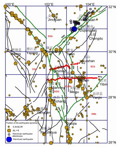
大凉山地块西边界安宁河-则木河断裂左旋滑动速率为6.5 mm/a[5~7],地震活动较强烈,曾发生3次7级以上强震.东边界峨边断裂附近也是地震活动区,曾发生两次7级以上强震[8~10].而大凉山断裂带以及大凉山地块内部的地震活动,中强震发生的频次明显小于大凉山地块的东、西两个边界带地区(见图 1).

|
图 1 区域构造、地震震中分布及MT测点布置图地块:SGb-松潘-甘孜地块,CDb-川滇地块,DLSb-大凉山地块,SCb-四川盆地,HNb-华南地块,小金河断裂(XJHf)和大凉山断裂之间的区域又称为康滇地轴(KDG); 断裂:YXf-玉树-鲜水河断裂,LMSf-龙门山断裂,ANHf-安宁河断裂,ZMHf-则木河断裂,XJf-小江断裂,EBf-峨边断裂,HYSf-华蓥山断裂,DLSf-大凉山断裂;WMf-汶川-茂县断裂,YBf-映秀-北川断裂,GJf-灌县-江油断裂;MT剖面:冕宁-宜宾(MYP); 石棉-乐山(SLP); 震中分布数据基于全国地震目录(史前-2009)[20]. Fig. 1 The location of MT profile?the earthquake epicenter and the tectonics in the surrounding area Blocks:SGb-Songpan-Ganti block, CDb-Chuandian block, DLSb-Daliangshan block, SCb-Sichuan basin block, HNb-Huanan block, The area between Xiaojinghe fault and Daliangshan fault also named KangDian Geo-axis (KDG):Faults:YXf-Y ushu-Xianshuihe fault, LMSf-Longmenshan fault, ANHf-Anninghe fault, ZMHf-Zemuhe fault, XJf-Xiaojiang fault, EBf-Ebian fault, HYSf-Huayingshan fault, DLSf-Daliangshan fault; WM--Wenchuan-Maoxian fault, YB--Yingxiu-Beichuan fault, GJf-Guanxian-Jiangyou fault; MT profile:Mianning-Yibin profile (MYp), Shimian-Leshan profile (SLp). Position of earthquake epicenter distribution from China Earthquake Catalog ((rom prehistory to 2009)[20] |
为了解释青藏高原地壳增厚和隆升机制,人们提出了不同的模型[11~15],如中、下地壳存在管流层的模型,青藏高原或四川盆地岩石圈的向下俯冲模型等.本文研究的冕宁-宜宾剖面在青藏高原东边缘大凉山地块的中部穿过,比前期研究的穿过大凉山地块北部的石棉-乐山剖面[16]更长,其研究结果对于青藏高原东边缘带更有代表性,不仅对该区的构造变形和地震活动性研究,而且对青藏高原地壳运动模式的研究都具有意义.
2 区域构造和地球物理背景大凉山地块位于青藏高原东边缘区(图 1),近南北走向,西侧由安宁河断裂、则木河断裂与川滇地块相隔,东侧经峨边断裂与四川盆地相邻.在北边界,由龙门山断裂把它与松潘-甘孜地块分隔,南边界的华蓥山断裂以南为华南地块[1, 4].
近南北走向的安宁河断裂倾向西,倾角在60°~80°以上,具有明显的挤压和走滑特征[8, 17].断裂带最宽处达数公里,沿断裂带挤压破碎及糜棱岩化现象普遍,属多期活动的大断裂.峨边断裂带由纵向排列的叠瓦式逆冲断裂系组成,逆冲强度南强北弱[10].大凉山地块内部大凉山断裂走向在N30°W至近南北向之间,宽约数十米至百余米不等,具明显的压性特征,晚新生代以来,表现出左旋走滑运动,总位移量最大为13.5~15.3km[18].大凉山地块西侧约15km深度存在约8~10km厚的低速层,而东侧却不存在.西侧地壳的平均速度为6.25km/s,上地幔速度为7.75km/s,均明显低于东侧的速度(地壳平均速度为6.45~6.50km/s,上地幔速度为8.00~8.20km/s)[3].近南北走向的布格重力异常强梯度带穿过大凉山地块,东部为-200×105 m/s2,西部为-400×105 m/s2 [19].
地质上把大凉山断裂以西至川滇地块东部,包括安宁河断裂带在内的区域称为康滇地轴,出露岩石主要为早元古代的花岗岩和变质岩.大凉山断裂和峨边断裂之间(以下称为大凉山地块)主要为古生代和中生代厚层碳酸岩和蒸发岩,峨边断裂带以东即四川盆地主要发育中生代陆相砂砾岩及泥岩[21].
3 大地电磁数据和电性结构冕宁-宜宾MT剖面(图 1)长约240km,近东西向展布,与区域构造走向基本垂直.剖面西起康滇地轴西部(川滇地块东部),向东穿过大凉山地块,止于四川盆地,并穿过安宁河断裂、大凉山断裂和峨边断裂等.沿剖面测点数86个,平均点距约3km.野外测量使用V5-2000仪器,采用远参考技术进行观测.每个测点测量2个相互正交的水平电场分量(Ex,Ey)和3个相互正交的磁场分量(Hx,Hy,Hz),下标x、y、z分别代表向北、向东和向下方向,每个测点观测一天时间.数据处理采用了Robust技术[22],获得资料的频率范围一般为320~0.0005Hz,用可视化二维分析、解释软件进行了分析[23].
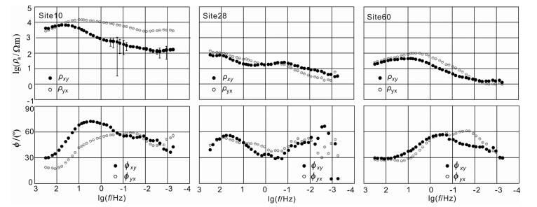
图 2为三个区段即康滇地轴(测点1~17)、大凉山地块(测点18~51)和四川盆地(测点52~86)具有代表性的3个测点(测点10,28和60)的视电阻率和相位曲线.康滇地轴的测点10的曲线显示,TE、TM两种极化模式的视电阻率曲线形态相似,主体电阻率变化趋势表现为由高频到低频,即由浅层到深层为低阻-高阻-低阻-高阻形式.与上地壳深度范围对应的视电阻率的极大值可达几千到几万欧姆米,大于其他区段,厚度也较大.高阻层下面为低阻层,随深度增加,电阻率增大.大凉山地块的测点28的曲线显示,电阻率随深度的变化形式为高阻-低阻-高阻-低阻形态,其中深部(大体与中地壳深度范围对应)的电阻率较小,且厚度较大.四川盆地的测点60的曲线形态呈现低阻-高阻-低阻的形态,即表层电阻率较低,之下为高电阻率层,然后随深度增大,电阻率减小.

|
图 2 三个地块的(康滇地轴(1~17测点),大凉山地块(18~51),四川盆地(52~86))典型测点10、28、60的视电阻率、相位曲线,其中xy代表TE模式,yx代表TM模式,上图为视电阻率曲线,纵坐标为视电阻率对数形式,下图为阻抗相位曲线,纵坐标为度,横坐标为频率的对数形式 Fig. 2 Apparent resistivity and phase curves at three sites numbered 10, 28 and 60 in three sections corresponding to tectonic unitsKDG (sites 1~17), DLSb (sites 18~51) and SCb (sites 52~86) The subscript xy denote TE model, yx denote TM model. First row for each site is apparent resistivity, where ordinates are logarithms of resistivity; second row is impedance phase, ordinates are degrees. Abscissas denote logarithms of frequencies (Hz) |
通过阻抗张量分解计算[24]发现,绝大部分测点的视电阻率、阻抗相位曲线形态在分解前后变化不大,说明它们受局部畸变影响较小.本文主要用Swift[25]技术对资料进行分析.大多数测点主体频段范围的电性走向为NNW-NNE (图 3),和区域构造方向相近.二维偏离度在大部分测点的主要频段小于0.3~0.4,符合二维电性结构的要求,适于进行二维反演解释.

|
图 3 冕宁-宜宾MT剖面频率0.01172 Hz分三段电性走向极化图其中方位N指向正北, 黑色阴影代表测点走向的角度, 长度代表测点个数. Fig. 3 Optimum Swift rotation angles at frequency 0.01172 Hz for sites laying three sections are shown in rose schemes N denote the north the black shadow denote the sites' strike angle, the length denotes the number of the sites. |
我们对沿剖面86个测点的TE和TM模式的视电阻率、阻抗相位数据进行了联合反演,在反演中使用RRI[26]和NLCG[27]等二维反演方法进行了对比试验,结果表明,两种反演方法得到的电性结构的主要特征一致,最后选用了NLCG方法反演的结果.在使用NLCG方法反演中,初始模型电阻率为100Ωm的均匀半空间,横向网格间距基本相等,网格数236个.纵向网格数为158个,考虑到沿剖面测点高差较大,浅部适当加密.采用的模型光滑参数为20,最后拟合均方差为6.8,分析主要原因为使用二维反演方法对TE模式进行反演时,由于TE模式数据加权小,数据拟合程度低,而TM模式数据拟合较好.
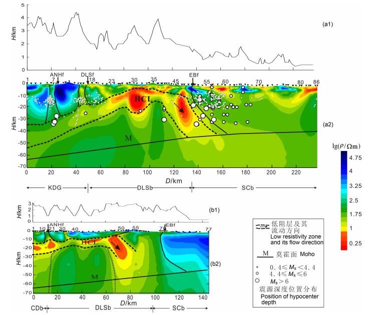
沿剖面的二维电性结构(图 4)与定性分析视电阻率曲线的认识一致.沿剖面电性结构可分为3个区段,自西向东分别与康滇地轴(第一区段)、大凉山地块(第二区段)和四川盆地(第三区段)对应,它们之间的边界分别与大凉山断裂和峨边断裂对应.

|
图 4 (al)沿冕宁一宜宾剖面的地形高度(H)示意图; (a2)冕宁一宜宾剖面的2D电性结构及地质解释图, 图中色标为电阻率值的对数形式, 2D模型上的三角为测点号; (bl)沿石棉一乐山剖面的地形高度(H)示意图; (b2)石棉一乐山剖面2D电性结构.KDG为康滇地轴, CDb为川滇地块, DLSb代表大凉山地块, SCb为四川盆地, ANHf为安宁河断裂, DLSf为大凉山断裂, EBf为峨边断裂, HCL为壳内高导层, 由于布置测点常位于地势较低处, 实际高差或许更大, D代表距离; (ρ代表电阻率, 红色区域电阻率 < 10Ωm, 0.4≤Ms < 4.4 (28.5°N~29°N)(l992~2002)基于朱艾斓[28]重新定位后的地震数据, 其他地震数据基于文献[20].图中莫霍面的深度参考崔作舟[2]及王春镛[3]的地震资料. Fig. 4 (al) The topography elevation (H) sketch along Mianning-Yibin profile; (a2)2D electrical structure along Mianning-Yibin profile (MYp) and geology interpretation map. The reversed triangles on the 2D electrical structure denote sites; (bl) The topography elevation (H) sketch along Shimian-Leshan profile; (b2)2D electrical structure along Shimian-Leshan profile (MYp). KDG:Kangdian Geo-axis, CDb-Chuandian block, DLSb-Daliangshan block, SCb-Sichuan basin block; ANHf-Anninghe fault; DLSf-Daliangshan fault, EBf-Ebian fault; HCL: High conductivity layer in the crust. Although elevation is from the MT sites which usually lie in the gully to reduce the geographic effect, or big the truth. D denote the distance, ρ denote the resistivity, the resistivity below l0 Ωm in the red area. The earthquake data (0.4≤Ms < 4.4) from relocation of the Httle earthquake (the projection between 28.5°N~29°N along the MTprofile) by Zhu Ailan[28] (from l992 to 2002). The other earthquake data from Ref.[20]. The depth of Moho refered to the seismic exploration data from Cuo Z Z[2] and Wang C Y[3] |
第一区段,上地壳为电阻率大于几千欧姆米的高阻层,最大厚度约30km,并自西向东逐渐减薄,至大凉山断裂处为20km左右,它可能反映了该区上地壳古老变质岩以及火成岩的高阻特征.高阻层之下为厚度20~25km的低阻层,它穿过安宁河断裂和大凉山断裂与第二区段的壳内高导层相连.低阻层之下,电阻率有所增大.与石棉-乐山剖面的电性结构相比,本区段上地壳的高阻层的厚度和电阻率都较大(图 4).
第二区段,是三个区段中总体电阻率最小的区段,可能反映了该区发育较厚的古生代和中生代碳酸岩和蒸发岩.浅层电阻率横向变化较大,反映该区段近地表断裂较发育,岩性变化较大.其下为一上拱的低阻层或高导层(HCL),在西部高导层顶面埋深约20km,到大凉山地块中部达到最浅,约5km (30号测点附近).再向东其深度呈现逐渐增大的趋势,最深处30km左右,并显示向四川盆地倾俯的现象.高导层的厚度一般约25km.高导层以下电阻率又增大,一般为几十至几百欧姆米.
第三区段,电性结构总体分为3层.第一层可分为上、下2个亚层,上亚层表现为高、低阻体横向相间排列的形式,下亚层为相对低阻层.第一层的底界深度由西部的约8km增加到东部的约15km.第二层表现为较厚的高阻层,其深度和厚度都显示向东逐渐增大的趋势,与中下地壳对应,其内部不存在高导层.在高阻层之下,电阻率又减小,与上地幔顶部对应.本区段的电性结构反映,四川盆地在浅部沉积岩层之下存在厚度较大、较坚硬的地壳.与石棉-乐山剖面相比,在浅层出现了厚度较大的相对低阻层(第一层),可能是因为本剖面进入四川盆地的长度比石棉-乐山剖面更长,更能反映四川盆地内浅部相对低阻的沉积层特征.
与剖面相交的主要断裂带电性结构特点与石棉-乐山剖面相似(图 4).安宁河断裂带(在剖面的20km坐标附近)被中地壳低阻层(高导层)切割成上、下两部分,上部为宽度约5km的垂向低阻带,电阻率小于东、西两侧的电阻率,其底界尖灭于中地壳低阻层顶部.低阻层以下为近垂直的电性边界,且东侧电阻率值高于西侧.大凉山断裂带(在剖面的45km坐标附近)为近垂向的低阻带,宽约几公里,断裂带底界与壳内低阻层相连.峨边断裂(在剖面的135km坐标附近)对应两侧有较大电阻率差异的边界,其深部有向东倾俯的趋势.
对比冕宁-宜宾剖面和石棉-乐山剖面的电性结构表明(图 4),康滇地轴的上地壳为高阻层,它覆盖在低阻层之上,以下电阻率又升高.大凉山地块内,以上拱的地壳高导层(低阻层)为主要标志.四川盆地的中下地壳整体为高阻体,不存在低阻层.
4 青藏高原东边缘地壳内流动低阻层的分析INDEPTH项目在藏南的探测发现了15~20km深度的高导层,电阻率小于10Ωm,推测它是含有部分熔融的淡色花岗岩,具有较低的黏滞度,易于流动和变形,称为地壳内的“管流”(channelflow)层[11, 12].研究认为,由于青藏高原地块遭受挤压、隆升、地壳增厚和变形等作用,以及地壳内部的岩石放射性热产生,使得青藏高原东部地区地壳内增温,导致地壳中下部岩石发生部分熔融,形成易于流动和变形的高导层(或管流层)[29~33].
地质研究认为,青藏高原东边缘广泛发育地壳滑脱构造[34~36],说明这里具有地壳内低黏滞层存在的条件.在本研究区的西北约50km的贡嘎山地区,发育有约12.8 Ma的花岗岩岩盖,Royden等[11]认为其是由大陆地壳部分熔融所形成的,并在地表有多处热泉.地热研究表明本区地壳内15~20km深度范围的温度约为500~600℃左右或更高[32].不同方法的地震波研究均揭示了川西高原的中下地壳存在低速层,结合中下地壳的S波速剧烈下降,高泊松比、低介质品质因子,可以认为中下地壳存在能够发生流动的强度弱软层;刘树文等[37]等从地球化学方面也得到同样的认识,所以,青藏高原东边缘中下地壳不仅存在部分熔融的条件,贡嘎山花岗岩本身也是地壳部分熔融的直接证据.对比分析青藏高原东边缘和南边缘地质和地球物理条件,推测在本研究区的地壳内低阻层(最小电阻率小于10Ωm)是由部分熔融的岩石组成的.根据岩石电阻率的实验数据,推测熔融含量可达10%左右,并可能含有百分之几的含盐流体[6].在地壳低阻层内,电阻率的分布也是不均匀的,电阻率较小的部分,岩石熔融含量可能较大,或可能含较多的含盐流体,且连通性较好,在含盐流体的参与下更容易发生部分熔融,促使中下地壳发生层流作用[38].
试验表明[32, 33],地壳物质的黏滞度随着熔融含量的增加急剧降低.青藏高原中部地壳内流动层(管流层)的黏滞度为1016Pa·s,高原东边缘向外侧地形高度缓慢降低的边缘带(四川盆地南、北部)管流层的黏滞度约为1018Pa·s,地形陡变的边界带(四川盆地边缘)黏滞度为1021Pa·s[12, 13].大凉山地块东西向宽仅百公里左右,而地壳厚度变化了近三分之一,地势高程变化剧烈,属于陡变边缘,推测黏滞度约为1021 Pa·s[32, 33].而在该区域沿着南东方向(川滇地块和大凉山地块的运动方向)地形高度和地壳厚度变化缓慢,黏滞度约为1018Pa·s.因此,推测本区壳内高导层的黏滞度应在1018~1021Pa·s之间.
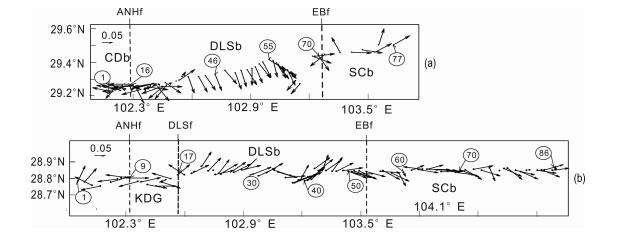
5 壳内高导层的几何学特征及构造意义磁感应矢量实部反映地下介质导电性分布的横向不均匀性,矢量大小反映横向导电性差异的大小,矢量方向指向高电导一侧.沿两个剖面的0.01~0.03Hz频率范围的实感应矢量(大约反映壳内高导层的深度)分布(图 5)表明,在大凉山地块范围,石棉-乐山剖面的实感应矢量指向剖面东南侧,而冕宁-宜宾剖面指向北东侧,说明高导层在石棉-乐山剖面和冕宁-宜宾剖面之间聚集,内部是连通的,并在冕宁-宜宾剖面附近导电性更强.考虑到二条剖面之间有60~70km的距离,以及每条剖面反演得到的结构反映剖面侧翼一定范围的电阻率,推测地壳内的高导层在南北向的分布范围至少有100km左右,且高导体的南北向展布和大凉山地块的走向基本一致.沿着东西方向,大凉山地块和川滇地块的下部存在连续的高导层,且在大凉山地块下部更导电.在东部,高导层终止于大凉山地块的东边界峨边断裂附近,且向四川盆地下倾俯.

|
图 5 石棉-乐山MT剖面(a)和冕宁-宜宾MT剖面(b)的磁感应矢量图 0.05代表磁感应矢量的缩放比例. Fig. 5 The real reduction vectors map of the MT profiles along Shimian-Leshan (a) and Mianning-Yibin (b) The 0.05 upper of the arrow denote the scale of the vector. |
青藏高原东部各地块的地壳向东或东南方向的运动,以及高原东边缘带巨大的高差产生的重力势能的联合作用,使地壳内易流动的高导层被挤出,它或者通过对上地壳的拖曳作用使上地壳发生运动[15],或者通过解耦作用使上地壳和下地壳发生拆离[3],这些运动与先存的或新生的逆冲断裂和走滑断裂的共同作用,使上地壳由西向东逐渐减薄,地表抬升.同时,地壳内的易流动层在向东或南东方向的运动中,受到东侧稳定、坚硬的四川盆地的阻挡,一方面转向南或南南东方向运动,另一方面向四川盆地下方发生倾俯.
在青藏高原东部和北部的其他大地电磁探测剖面也发现地壳内高导层的存在,并显示向东至南东方向的运动[39~43].大地电磁剖面揭示的地壳内高导层的分布与GPS速度分布显示的浅层地壳的运动形态[6]是一致的.
在大凉山地块的西边界即安宁河-则木河断裂带和大凉山断裂带的两侧,地壳内低阻层是连通的,尽管西侧的电阻率大于东侧的电阻率.GPS速度分布显示位移速度的方向在该断裂两侧具有连续性,尽管东侧的速度小于西侧[6].在大凉山地块的东部,即靠近四川盆地的边界附近,GPS显示的运动方向发生了由南南东方向转向正南或南南西方向的“转弯”现象,与推测的地壳内低阻层的运动方向一致.而在大凉山地块内部,GPS速度分布显示运动方向较一致地指向近似向南的方向.
地壳内低阻层的导电性和运动形态出现横向差异的地区往往对应地震较活跃的地区.例如,安宁河断裂带的浅部为近直立的低阻带,电阻率明显地小于两侧的电阻率,深部是两侧具有不同电阻率的电性边界.而安宁河断裂带显示具有较大的左旋运动速率,并且是强地震分部带(图 1),同时小震密集分布.峨边断裂带对应两侧电性结构明显不同的边界,这里也是地震较强活动的地区,中强震较多,小震频发.而在大凉山地块内部,地壳内低阻层分布及其运动形式变化不大,历史纪录的中强地震少,小震活动也比两侧边界带弱.
6 结论和讨论通过对冕宁-宜宾大地电磁剖面(MT)电性结构的探测研究,取得如下认识:
(1)沿剖面的电性结构可分成3个区段,分别对应康滇地轴、大凉山地块和四川盆地.在康滇地轴和大凉山地块存在向上拱起的地壳内的高导层,它切穿了安宁河断裂带和大凉山断裂带.而在四川盆地不存在地壳内的高导层.
(2)大凉山地块的壳内高导层一方面可能存在向南南东或向南方向的运动,另一方面由于东侧四川盆地的阻挡,发生向东的深部倾俯现象.壳内高导层的存在可能影响到青藏高原东边缘带的地壳抬升.
(3)在地壳内低阻层发生横向变异的地区,如断裂带地区,往往是地震活动较强的地区.
| [1] | 徐锡伟, 张培震, 闻学泽, 等. 川西及其邻近地区活动构造基本特征与强震复发模型. 地震地质 , 2005, 27(3): 446–461. Xu X W, Zhang P Z, Wen X Z, et al. Features of active tectonics and recurrence behaviors of strong earthquakes in the western Sichuan province and its adjacent regions. Seismology and Geology (in Chinese) , 2005, 27(3): 446-461. |
| [2] | 崔作舟, 卢德源, 陈纪平, 等. 攀西地区的深部地壳结构与构造. 地球物理学报 , 1987, 30(6): 566–580. Cui Z Z, Lu D Y, Chen J P, et al. The structure and the tectonic of the deep crust in Panxi Area. Chinese.J.Geophys (in Chinese) , 1987, 30(6): 566-580. |
| [3] | Wang C Y, Han W B, Wu J P, et al. Crustal structure beneath the eastern margin of the Tibetan Plateau and its tectonic implications. J.Geophys.Res. , 2007, 112(B07307). DOI:10.1029/2005JB003873 |
| [4] | 马杏垣. 中国岩石圈动力学图集. 北京: 中国地图出版社, 1989 . Ma X Y. Lithospheric Dynamics Atlas of China (in Chinese). Beijing: China Cartographic Publishing House, 1989 . |
| [5] | 张培震, 沈正康, 王敏, 等. 青藏高原及周边现今构造变形的运动学. 地震地质 , 2004, 26(3): 367–377. Zhang P Z, Shen Z K, Wang M, et al. Kinematics of present-day tectonic deformation of the Tibetan plateau and its vicinities. Seismology and Geology (in Chinese) , 2004, 26(3): 367-377. |
| [6] | 王阎昭, 王恩宁, 沈正康, 等. 基于GPS资料约束反演川滇地区主要断裂现今活动速率. 中国科学D辑 , 2008, 51(9): 1267–1283. Wang Y Z, Wang E N, Shen Z K, et al. GPS-constrained inversion of present-day slip rates along major faults of the Sichuan-Yunnan region, China. Science in China (D) (in Chinese) , 2008, 51(9): 1267-1283. DOI:10.1007/s11430-008-0106-4 |
| [7] | 张培震, 徐锡伟, 闻学泽, 等. 2008年汶川8.0级地震发震断裂的滑动速率、复发周期和构造成因. 地球物理学报 , 2008, 51(4): 1066–1073. Zhang P Z, Xu X W, Wen X Z, et al. Slip rates and recurrence intervals of the Longmen Shan active fault zone, and teetonic implications for the mechanism of the May 12 Wenchuan earthquake, 2008, Sichuan, China. Chinese.J.Geophys (in Chinese) , 2008, 51(4): 1066-1073. |
| [8] | 苏有锦, 秦嘉政. 川滇地区强地震活动与区域新构造运动的关系. 中国地震 , 2001, 27(3): 24–34. Su Y J, Qin J Z. Strong earthquake activity and relation to regional neotectonic movement in Sichuan-Yunnan region China. Earthquake Research in China (in Chinese) , 2001, 27(3): 24-34. |
| [9] | 韩渭宾, 蒋国芳. 川滇地区强震活动分布特征及其与地壳块体构造背景关系的研究. 地震学报 , 2004, 26(3): 211–222. Han W B, Jiang G F. Study on distribution characteristics of strong earthquakes in Sichuan-Yunnan area and their geological tectonic background. Acta Seismlogica Sinica (in Chinese) , 2004, 26(3): 211-222. |
| [10] | 彭云金, 吕加蓉. 荥经一马边一盐津断裂带新活动特征分析. 四川地震 , 2004(3): 34–36. Peng Y J, Lu J R. Consideration about the neo-active feature of Yingjing-Mabian-Yanjin fault zone. Earthquake Research in Sichuan (in Chinese) , 2004(3): 34-36. |
| [11] | Royden L H, Clark B, King R W, et al. Surface deformation and lower crustal flow in eastern Tibet. Science , 1997, 276(5313): 788-790. DOI:10.1126/science.276.5313.788 |
| [12] | Clark M K, Royden L H. Topographic ooze:Building the Eastern margin of Tibet by lower crustal flow. Geology , 2000, 28(8): 703-706. DOI:10.1130/0091-7613(2000)28<703:TOBTEM>2.0.CO;2 |
| [13] | Clark M, Royden L, Burchfiel B C, et al. Late Cenozoic uplift of southeastern Tibet:Implication for lower crustal flow. Geophys.Res.Abs , 2003, 5: 12969. |
| [14] | Schoenbohm L M, Burchfiel B C, Chen L. Propagation of surface uplift, lower crustal flow, and Cenozoic tectonics of the southeast margin of the Tibetan Plateau. Geology , 2006, 34(10): 813-816. DOI:10.1130/G22679.1 |
| [15] | Tapponnier P G, Peltzer A Y, Dain I E, et al. Propagating extrusion tectonics in Asia:new insight from simple experiments with plasticine. Geology , 1982, 10: 611-616. DOI:10.1130/0091-7613(1982)10<611:PETIAN>2.0.CO;2 |
| [16] | 赵国泽, 陈小斌, 王立凤, 等. 青藏高原东边缘地壳"管流"层的电磁探测证据. 科学通报 , 2008, 52(12): 1887–1893. Zhao G Z, Chen X B, Wang L F, et al. Evidence of crustal 'channel flow' in eastern margin of Tibet plateau from MT measurements. Chinese Science Bulletin (in Chinese) , 2008, 52(12): 1887-1893. |
| [17] | Zhao G, Wang L, Chen X, et al. The active fault belts in eastern Tibet margin inferred using magnetotellurics. Geologica Acta , 2010, 8(1): 103-114. |
| [18] | 申旭辉, 陈正位, 许任德, 等. 凉山活动构造带晚新生代变形与位移规模. 地震地质 , 2000, 22(3): 232–238. Shen X H, Chen Z W, Xu R D, et al. Deformation characteristics and displacement amount of the Liangshan active fault zone in Late Cenozoic era. Seismology and Geology (in Chinese) , 2000, 22(3): 232-238. |
| [19] | 楼海, 王春镛. 川滇地区重力异常的小波分解与解释. 地震学报 , 2005, 27(5): 515–523. Lou H, Wang C Y. Wavelet analysis and interpretation of gravity data in Sichuan-Yunnan region, China. Acta Seimologica Sinica (in Chinese) , 2005, 27(5): 515-523. |
| [20] | 中国地震台网地震目录, http://www.csndmc.ac.cn/newweb/data/2009-04-08. China Seismic Network Earthquake Catalog, http://www.csndmc.ac.cn/newweb/data/2009-04-08. |
| [21] | 四川省地质矿产局. 四川区域地质志. 北京: 地质出版社, 1991 . Bureau of Geology and Mineral Resources of Sichuan Province. Regional Geology of Sichuan Province (in Chinese). Beijing: Geological Publishing House, 1991 . |
| [22] | 江钊, 刘国栋, 孙洁, 等. Robust估计及其在大地电磁资料处理中的应用.见刘国栋等编电磁方法研究与勘探. 北京: 地震出版社, 1993 : 60 -69. Jiang Z, Liu G D, Sun J, et al. Robust estimation and its application in the MT data processing.In:Liu G D, et al.eds.Investigation and Application of Electromagnetic Methods (in Chinese). Beijing: Seismological Press, 1993 : 60 -69. |
| [23] | 陈小斌, 赵国泽, 詹艳. MT资料处理与解释的Windows可视化集成系统. 石油地球物理勘探 , 2004, 39(sup): 11–16. Chen X B, Zhao G Z, Zhan Y. Visual window system for MT data processing and interpretation. Geophys Prosp Petrol (in Chinese) , 2004, 39(sup): 11-16. |
| [24] | Groom R W, Bailey R C. Decomposition of the magnetotelluric impedance tensor in the presence of local three-dimensional galvanic distortion. J.Geophys.Res , 1989, 94: 1913-1925. DOI:10.1029/JB094iB02p01913 |
| [25] | Swift C M.A magnetotelluric investigation of electrical conductivity anomaly in the southwestern united States.Doctoral thesis.Cambridge, Massachusetts Institute of Technology, Massachusetts USA, 1967 |
| [26] | Smith J T, Booker J R. Rapid inversion of two-and three-dimensional magnetotelluric data. J.Geophys.Res. , 1991, 96(B3): 3905-3922. DOI:10.1029/90JB02416 |
| [27] | Rodi W, Mackie R L. Nonlinear conjugate gradients algorithm for 2-D magnetotelluric inversion. Geophysics , 2001, 66(1): 174-187. DOI:10.1190/1.1444893 |
| [28] | 朱艾斓, 徐锡伟, 周永胜, 等. 川西地区小震重新定位及其活动构造意义. 地球物理学报 , 2005, 48(3): 629–636. Zhu A L, Xu X W, Zhou Y S, et al. Relocation of small earthquakes in west Sichuan, China and its implications for active tectonic. Chinese.J.Geophy (in Chinese) , 2005, 48(3): 629-636. |
| [29] | Pham V N, Boyer D, Therme P, et al. Partial melting zones in the crust in Southern Tibet from magnetotelluric results. Nature , 1986, 319: 310-314. DOI:10.1038/319310a0 |
| [30] | Chen L S, Booker J R, Jones A G, et al. Electrically conductive crust in southern Tibet from INDEPTH magnetotelluric surveying. Science , 1996, 274: 1694-1696. DOI:10.1126/science.274.5293.1694 |
| [31] | Nelson K D, Zhao W J, Brown L D, et al. Partially molten middle crust beneath southern Tibet:synthesis of project INDEPTH results. Science , 1996, 274: 1684-1687. DOI:10.1126/science.274.5293.1684 |
| [32] | Rosenberg C, Handy M R. Experimental deformation of partially melted granite revisited:implications for the continental crust. J.Metamorph.Geol , 2005, 23: 19-28. DOI:10.1111/jmg.2005.23.issue-1 |
| [33] | Rutter E, Neumann K. Experimental deformation of partially molten Westerly granite under fluid absent conditions with implications for the extraction of granite magmas. J.G.R , 1995, 100: 15697-15715. DOI:10.1029/94JB03388 |
| [34] | 王宗秀, 许志琴, 杨天南, 等. 川西鲜水河断裂带变形机制研究-一个浅层次的高温韧性平移剪切带. 中国区域地质 , 1996(3): 245–251. Wang Z X, Xu Z Q, Yang T N, et al. Study of the deformation mechanism of the Xianshui river fault zone:a shallow level, high temperature ductile shear zone. Reg.Geol China (in Chinese) , 1996(3): 245-251. |
| [35] | 孙圣思, 贾东, 胡潜伟, 等. 新生代贡嘎山花岗岩中的流体包裹体面测试及其应力场分析. 高校地质学报 , 2007, 13(2): 344–352. Sun S C, Jia D, Hu Q W, et al. Fluid inclusion planes measurement and paleostress field analysis for Cenozoic Gonggashan granite. Geol.J.China.Univ (in Chinese) , 2007, 13(2): 344-352. |
| [36] | 张岳桥, 陈文, 杨农. 川西鲜水河断裂带新生代剪切变形~(40) Ar/~(39) Ar测年及其构造意义. 中国科学(D辑:地球科学) , 2004, 47(4): 794–803. Zhang Y Q, Chen W, Yang N. ~(40) Ar/~(39) Ar dating of shear deformation of the Xianshuihe fault zone in west Sichuan and its tectonic significance. Sci.China.Ser D-Earth Sci (in Chinese) , 2004, 47(4): 794-803. |
| [37] | 刘树文, 张进江, 舒桂明, 等. 藏南定结铁镁质麻粒岩矿物化学、PTt轨迹和折返过程. 中国科学(D辑:地球科学) , 2005, 35(9): 810–820. Liu S W, Zhang J J, Shu G M, et al. ZangNan consolidated cafemic-granulite rocks and minerals, chemical, PTt turn-back process. Science in China (D) (in Chinese) , 2005, 35(9): 810-820. |
| [38] | 张培震. 青藏高原东缘川西地区的现今构造变形、应变分配与深部动力过程. 中国科学(D辑:地球科学) , 2008, 38(9): 1041–1056. Zhang P Z. ChuanXi areas' tectonic deformation, strain distribution now with deep dynamic process in The eastern Tibet margin. Science in China (D) (in Chinese) , 2008, 38(9): 1041-1056. |
| [39] | Unsworth M, Wei W, Jones A G, et al. Crustal and upper mantle structure of northern Tibet imaged with magn-etotelluric data. J.Geophys.Res , 2004, 109(B02403). DOI:10.1029/2002JB002305 |
| [40] | 孙洁, 晋光文, 白登海, 等. 青藏高原东缘地壳、上地幔电性结构探测及其构造意义. 中国科学(D辑:地球科学) , 2003, 33(sup): 173–180. Sun J, Jin G, Bai D H, et al. Sounding of electrical structure of the crust and upper mantle along the eastern border of Qinghai-Tibet Plateau and its tectonic significance. Science in China (D) (in Chinese) , 2003, 33(sup): 173-180. |
| [41] | 赵国泽, 汤吉, 詹艳, 等. 青藏高原东北缘地壳电性结构和地块变形关系的研究. 中国科学(D:地球科学) , 2005, 48(10): 1613–1626. Zhao G, Tang J, Zhan Y, et al. Relation between electricity structure of the crust and deformation of crustal blocks on the northeastern margin of Qinghai-Tibet plateau. Science in China (D) (in Chinese) , 2005, 48(10): 1613-1626. DOI:10.1360/02YD0047 |
| [42] | 马晓冰, 孔祥儒, 刘宏兵, 等. 青藏高原东北部地区地壳电性结构特征. 地球物理学报 , 2005, 48(3): 689–697. Ma X B, Kong X R, Liu H B, et al. The electrical structure of northeastern Qinghai-Tibet Plateau. Chinese J.Geophys (in Chinese) , 2005, 48(3): 689-697. |
| [43] | 赵国泽, 陈小斌, 肖骑彬, 等. 汶川M_s8.0级地震成因三"层次"分析-基于深部电性结构. 地球物理学报 , 2009, 52(2): 553–563. Zhao Guo Z, Chen X B, Xiao Q B, et al. Generation mechanism of Wenchuan strong earthquake of M_s=8.0 inferred from EM measurements in three levers. Chinese.J.Geophys (in Chinese) , 2009, 52(2): 553-563. |
 2010, Vol. 53


