 2020, Vol. 19


2) Innovation Academy of South China Sea Ecology and Environmental Engineering, Chinese Academy of Sciences, Guangzhou 510301, China;
3) University of Chinese Academy of Sciences, Beijing 100049, China;
4) Fourth Institute of Oceanography, Ministry of Natural Resources, Beihai 536007, China;
5) South China Sea Institute of Planning and Environmental Research, Ministry of Natural Resources, Guangzhou 510310, China
Volcanoes are a basic tectonic element that has a great impact on the shape of the Earth's surface. No matter if the volcanoes are alive or dead, they reveal fundamental process of magma flux from Earth's interior to its surface, and show how the material and energy circulate inside the Earth at present days or in the past. Among them, large volcanoes with anomalously thick crust record super lithospheric accretion of the continent and ocean. Compared to the well-studied mid-ocean ridge and arc magmatism, the formation of large volcanoes remains poorly understood. Scientists work on large volcanoes starting with continental flood basalts owing to the high accessibility of researching on land (e.g., Macdougall, 1988). As advanced development of marine science and technology a lot of massive volcanic features have subsequently been discovered in the oceans, such as volcanic passive margins and oceanic plateaus (e.g., Mahoney and Coffin, 1997). People consider continental flood basalts, volcanic passive margins and oceanic plateaus as a catalog of immense volcanic architectures, named large igneous provinces (Fig. 1). Large igneous provinces illuminate surface volcanism, mantle dynamics, and environmental impact.

|
Fig. 1 Global view of large igneous provinces, highlighting oceanic plateaus. The global seafloor bathymetry is provided by Sandwell et al. (2014). Large igneous provinces on Earth consist of continental flood basalts (red), volcanic passive margins (purple) and oceanic plateaus (orange). Large igneous provinces are surface expressions of the material and energy circulation of Earth's interior. These features formed by super crustal accretions on lands and in the oceans record the flux of magma from the mantle to the lithosphere in the past hundreds of million years and nowadays. OJP, Ontong Java Plateau; SR, Shatsky Rise; CAMP, central Atlantic magmatic province. |
Large igneous provinces, representing large-scale mafic magmatism, have been increasingly surveyed on multidisciplinary subjects, like high-precision geochronology, detailed geochemistry, and sophisticated geophysics. Continental flood basalts have the most data because abundant samples are available on the continents for transdisciplinary studies. Successful examples contain the Siberian traps (Renne and Basu, 1991), the Columbia River flood basalt province (Carlson, 1984), and the Madagascar Cretaceous basalts (Mahoney et al., 1991). On the contrary, sampling is difficult for either volcanic passive margins or oceanic plateaus. Nevertheless, geophysical mapping and seismic imaging are relatively effective in the oceans. Growing data, therefore, have been collected on oceanic large igneous provinces. Paradigms include the Red Sea volcanic margin (Wolfenden et al., 2005), the eastern India volcanic rifted margin (Subrahmanyam and Chand, 2006), the North Atlantic igneous province (Saunders et al., 2013), the Ontong Java Plateau (Korenaga, 2005; Taylor, 2006), the Kerguelen Plateau (Rotstein et al., 1990; Gladczenko and Coffin, 2001) and the Shatsky Rise (Sager et al., 2013, 2019).
Main findings in recent years include the followings (Mahoney and Coffin, 1997; Anderson, 2005; Neal et al., 2015). These massive igneous events are long-lived in the last several hundred million years, and play a significant role in the Earth's Wilson Cycle, even on other terrestrial planets. The origin of many large igneous provinces is related to hot diapirs rising from deep mantle onto the Earth's surface, i.e., Mantle Plume hypothesis (Richards et al., 1989; Mahoney and Spencer, 1991; Coffin and Eodlholm, 1994). Oceanic plateaus and volcanic passive margins are the ocean counterparts of continental flood basalts.
There is however not a one-fit-all application to the origin of large igneous provinces. For instance, in spite of the realization of plume involvement during the magmatic process, scientists inferred the plume geodynamics in a different way. Some claimed the plume is the main source of magma or a thermal anomaly driving the lithospheric melting (Coffin and Eldholm, 1994). Others thought it is similar to melts entrained by the plume to feed the asthenosphere and erupt at plate boundaries or cracks (Androvandi et al., 2011). Moreover, a few studies challenged the plume hypothesis. For example, Iceland was widely thought to be formed overlying a mantle plume, but geophysical observations do not match the deep mantle plume predictions. Seismic tomography shows a low-wave-speed anomaly terminated in the transition zone, not extend deeper into the lower mantle (Foulger et al., 2001). Their implication herein is that the melt anomalies of Iceland volcanism do not root deep into the mantle but at shallow depth, i.e., is an upper mantle plume.
2 Origin of Oceanic PlateausOceanic plateaus are a key member of large igneous provinces. They are extensive undersea volcanoes generally in a dome-like shape. Their summit appears nearly flat and the slopes of mountain flanks usually go as low as 1° or less. Nonetheless, the debate about the origin of oceanic plateaus is alive for years regarding whether melting anomalies arise from hot diapirs from the deep mantle, the Mantle Plume hypothesis, or are fuelled by shallow mantle processes associated with plate tectonics, the Plate Boundary hypothesis (Fig. 2; Anderson, 2005; Foulger, 2007, 2010). This debate contains rich crossdisciplinary subjects in Earth science and seems to be an extraordinary challenge for scientists to reach an agreement due to lacking substantial evidencing.

|
Fig. 2 Two competing formation hypotheses of oceanic plateaus, the mantle plume (left) versus plate boundary models (right), modified from Sager et al. (2016). Double lines on the seafloor represent spreading ridges with arrows showing relative plate motions. A spreading ridge triple junction is inferred here because Shatsky Rise and Kerguelen Plateau were formed at or near the triple junction of mid-ocean ridges (Nakanishi et al., 1999; Frey et al., 2000; Sager et al., 2019). Ontong Java Plateau is unclear whether it was formed at a triple junction, but at least in near-ridge setting (Taylor, 2006). Pink areas in the mantle denote upwelling. Sketches are not to scale. The plume model, which predicts a hot plume rises from lower mantle to the bottom of lithosphere, carrying a large amount of magma erupted near spreading ridges. The plate model indicates the melts anomaly comes from the upper mantle, where fertile magma occurs due to decompression melting at the spreading ridges. |
The mantle plume and plate boundary hypotheses basically can be strongly evidenced by seismic imaging of the crust and mantle, vertical motions of Earth's surface, the physical origins of surface erupted magma and the melt source, the spatial and temporal pattern of volcanism, magma volumes, and temperature of the mantle source rocks (Foulger, 2010). Other evidence may come from the effect of pre-existing lithospheric structure on localizing volcanism and planetary volcanism, which are still premature.
Another explanation is related to meteorite impact or bolide impact (Rogers, 1982; Ingle and Coffin, 2004). They suggest the formation of oceanic plateaus results from a large cosmic impact. However, the lack of evidence in meteorite samples and colliding imprints leads to the very limited acceptance of this hypothesis.
This paper aims to describe the three largest oceanic plateaus on our planet in great details based on observations of marine geology, geophysics, and geochemistry. Comparison of these three oceanic plateaus can provide insights in commonality and discrepancy in oceanic plateau formation. This cross-disciplinary study of marine geosciences is useful for testing the formation hypotheses of oceanic plateaus as proposed above and is important for better understanding the tectonic and geodynamic processes of extraordinary magma fluxes from mantle to lithosphere.
3 Three Largest Oceanic Plateaus on Earth 3.1 Ontong Java PlateauThe Ontong Java Plateau, the largest oceanic plateau on the Earth, is located near the Equator in the western Pacific Ocean (Fig. 3), 2000 km northeast of Australia. On the southwest of the plateau are the Solomon Islands and the New Britain Trench. Several abyssal basins surround the plateau with regional seafloor of 4000–5000 m water depth, the Layra Basin to the west, the east Mariana Basin to the north, the Nauru Basin to the east and the Stewart Basin to the southeast. The plateau summits reach 1000–3000 m water depth and 2500 m elevated from ambient basins.

|
Fig. 3 Topography of the three largest oceanic plateaus on the Earth, Ontong Java Plateau (OJP), Kerguelen Plateau (KP) and Shatsky Rise (SR). The seafloor bathymetry is provided by Sandwell et al. (2014). Black lines denote magnetic lineations and fracture zones, and numbers show relevant ages (Müller et al., 2008). NKP, CKP, SKP, north, central, south Kergulen Plateau. |
The dimension of the Ontong Java Plateau is the world's largest among all oceanic plateaus, with an area of 1.9× 10⁶ km2, a volume of 5.7×10⁷ km3 and an average crustal thickness of 30 km (a maximum of 38 km, from seismic imaging of Ridley and Richards (2010)). It consists of two bathymetric highs, the Main Plateau and the Eastern Salient. Scientists propose the plateau used to be even larger because a complex of the Ontong Java PlateauManihiki Plateau-Hikurangi Plateau was broken up by seafloor spreading after the complex was formed at a close time (Taylor, 2006).
Ocean drilling programs recovered a bunch of basaltic rock samples, which are critical to study the igneous basement of the Ontong Java Plateau. Radiometric dates of the igneous basement show that the Ontong Java Plateau was created from 122–90 Myr (Mahoney and Spencer, 1991). It took 32 million years to build up this immense construct, which implies a fast volcanic emplacement. After 90 Myr, late-stage volcanism occurred over the plateau with a small and random distribution.
For the origin of the Ontong Java Plateau, it is widely accepted due to cataclysmic melting in the inflated heads of risen mantle plumes or a single mantle superplume (Richards et al., 1989). However, some controversies arise from the following arguments. Mantle plume hypothesis predicts a plume tail comes after the plume head, but no observations of a subsequent island chain mismatch the prediction. The plateau no longer sits above the mantle plume, making it impossible to obtain direct observations to prove the existence and properties of the plume(s). Submarine eruptions and anomalous subsidence during the entire plateau formation also do not fit the dynamic uplift from the mantle predictions (Fig. 4; Korenaga, 2005).

|
Fig. 4 Residual bathymetry (up) and free-air gravity anomaly (bottom, Sandwell et al., 2014) of Ontong Java Plateau (OJP), Kerguelen Plateau (KP) and Shatsky Rise (SR). In the residual bathymetry maps, blanks denote subaerial areas. Seafloor bathymetry, sediment thickness, and crustal age were used to calculate residual bathymetry (Divins, 2003; Müller et al., 2008; Sandwell et al., 2014). To reveal bathymetry at formation time of the oceanic plateaus, the residual bathymetry is obtained after sediment and thermal corrections. |
The Ontong Java Plateau was unfortunately formed during the Cretaceous quiet zone (118–84 Myr), it is not feasible to reconstruct its tectonic evolution by magnetic anomaly data. From numerical modeling, workers indicate the plateau may have been near fast-spreading midocean ridges (Mohoney and Spencer, 1991; Ito and Clift, 1998). From samples of igneous rocks over the plateau, their geochemical and isotopic signatures (Fig. 5) lie in between the ranges of mid-ocean ridge basalts (MORB) and ocean island basalts (OIB). Former is related to the plate boundary model, whereas the latter is associated with the mantle plume model. To explain this discrepancy, people suggest a hybrid hypothesis, which claims that a perisphere containing melting anomaly (OIB-like) exists close to mid-ocean ridges, and the perisphere can either draws the ridges to jump onto the top of the perisphere then produce massive magmatism (Anderson et al., 1992; Smith and Lewis, 1999; Hamilton, 2002), or the perisphere can pump extraordinary melts into the asthenosphere and erupt along the mid-ocean ridges during seafloor spreading (Androvandi et al., 2011).

|
Fig. 5 Isotopic signatures of basaltic basement rocks from Ontong Java Plateau, Kerguelen Plateau and Shatsky Rise. Isotope ratio plots of Pb versus Nd (a) and Nd versus Hf (b) isotopic compositions are modified from Sager et al. (2016) and Heydolph et al. (2014), and see these references for additional data information. EPR, east Pacific Rise; N-MORB, normal mid-ocean ridge basalt; OIB, ocean island basalt. |
As the second biggest oceanic plateau in the world, the Kerguelen Plateau sits in the south Indian Ocean, 500 km of Antarctica (Fig. 3). Its summit water depth is 1000–3000 m, and 2000–3000 m higher than that of the surrounding seafloor. Unlike the Ontong Java Plateau, this plateau has three subaerial islands, the Kerguelen, Heard and McDonald Islands. Compared to the rounded shape of the Ontong Java Plateau, the Kerguelen Plateau is elongated in NW–SE orientation, 2300 km long and 500 km wide and with an area of 1.25×10⁶ km2. Bathymetry of the plateau appears to be progressively shallower towards NW, while crustal thickness thinnings along the plateau axis (south 22 km, central 19–21 km, and north 14–19 km, from 2D seismic profiles in Schaming and Rotstein, 1990; Gladczenko and Coffin, 2001). The plateau is composed of four bathymetric highs, the South Kerguelen Plateau, the Central Kerguelen Plateau (including the Heard and McDonald Islands), the north Kerguelen Plateau and the Elan Bank in the west. The Kerguelen Plateau must have been bigger because plate reconstruction results indicate that the central Kerguelen Plateau was formed together with the Broken Ridge, which is now separated to the northeast by the Southeast Indian Ridge (Frey et al., 2000). In addition, two deep-sea basins embrace the plateau, the Enderby Basin in the west and the Labuan Basin in the east. The basin water depth reaches 4000–5000 m.
The Kerguelen Plateau was built up initially in Cretaceous (120 Myr) and it lives long until present days. Igneous basement rocks cored at places over the plateau show the age progression along the NW–SE elongated morphology (Coffin et al., 2002; Kinman et al., 2009). The South Kerguelen Plateau was the beginning of volcanic production, at a time of 120 Myr. The Elan Bank and central Kerguelen Plateau was constructed subsequently 105 and 100 Myr, respectively. And then the Broken Ridge was formed around 95 Myr. The North Kerguelen Plateau began to form afterward 40 Myr. The Heard and McDonald islands on the North Kerguelen Plateau are present-day volcanism (active from 40 Myr to present).
The initiation of Kerguelen magmatism was in small dimension, which is different from continental flood basalts and the Shatsky Rise below that they started with massive eruptions. Relationship with the Antarctica continent and the continental breakup of Gondwana could be the reason why the Kerguelen Plateau began with small eruptions (Benerd et al., 2010). A few studies imply that the South Kerguelen Plateau and Elan Bank contain continental remnants (Operto and Charvis, 1995). Moreover, the long-lived duration (120 Myr to present) of Kerguelen magmatism clearly differs from those of the Ontong Java Plateau and the Shatsky Rise with rapid emplacement rates (both 30 million years). The subaerial eruption environment of the Kerguelen Plateau (Fig. 4; Frey et al., 2000) also raises another difference from the submarine volcanism of the Ontong Java Plateau and the Shatsky Rise.
Tholeiite basalts from drilling sites atop the Kerguelen Plateau contain OIB geochemical signature from isotope analysis (Fig. 5; Coffin et al., 2002; Kinman et al., 2009). It is apparently unlike MORB in terms of incompatible elements and Sr and Nd contents. The Source of igneous rocks is inferred to originate from deep mantle and preferably be linked to mantle plume. Nevertheless, a plume head prediction is not consistent with the small-scale initial eruption of the Kerguelen Plateau. Furthermore, geochemical characteristics on major, trace elements and isopotic ratios indicate that the Kerguelen basalts seem to be not as homogeneous as typical OIB. The inference herein is that melts entrained by a plume may have been mixed into the asthenosphere when the plume is near ridge spreading centers (Androvandi et al., 2011). The Kerguelen Plateau was formed near the Rodrigues ridge-ridge-ridge triple junction (the southeast Indian Ridge, southwest Indian Ridge, and central Indian Ridge), implying a clear relation to seafloor spreading. If a plume exists, it requires a plumeridge interaction for the Kerguelen Plateau.
3.3 Shatsky RiseRanking after the Ontong Java Plateau and the Kerguelen Plateau in size, the Shatsky Rise has areal and voluminal dimensions of 5.33×10⁵ km2 and 6.9×10⁶ km3, respectively (Sager et al., 1999; Zhang et al., 2015, 2016, 2017; Zhang and Chen, 2017). The rise lies in the northwest Pacific Ocean, 1500 km east of Japan (Fig. 3). It is elevated 4000 m from ambient basins in 6000 m water depth. Within Shatksy Rise, three isolated, large underwater volcanoes (Tamu Massif, Ori Massif, and Shirshov Massif), and a low ridge (Papanin Ridge) are almost linearly arranged in the NE–SW direction. Overall it appears to be elongated in shape like the Kerguelen Plateau. The isolation of volcanic edifices within the Shatsky Rise, however, is distinct from the connection of the south, central and north Kerguelen Plateau, Skiff Bank and Elan Bank.
The Shatsky Rise was formed quickly in late JurassicEarly Cretaceous (147–121 Myr). In contrast to the Ontong Java Plateau and the Kerguelen Plateau formed during the Cretaceous quiet zone, it is fortunate that the formation of the Shatsky Rise occurred in magnetic reversal period, providing it opportunity to trace the magnetic anomaly and decode its tectonic evolution. Magnetic anomaly data reveal that the Shatsky Rise was located at the junction of two magnetic lineation sets (Nakanishi et al., 1999), and drill cores from the igneous basement highs indicate rock ages match those of nearby linear magnetic anomalies (Mahoney et al., 2005; Geldmacher et al., 2014), which imply that the plateau must have been created at a ridge-ridge-ridge triple junction. This triple junction was composed of the divergence of the Pacific, Izanagi, and Farallon Plates. The Izanagi Plate has been completely carried away underneath the Aleutian Trench, while the Farallon Plate has been almost subducted beneath North America. Hence, the original size of the Shatsky Rise could be even larger since parts may have been subducted to the north and the east along the Izanagi and Farallon plates, respectively.
Magmatism of the Shatsky Rise started in the south at the location of the Tamu Massif, which is the oldest and largest edifice within the plateau (Sager et al., 1999). The initial volcanic eruption is vast, then the volume progressively decreases and the smaller Ori and Shirshov massifs and the Papanin Ridge were constructed. The transition from thick sheeted basalts on the Tamu Massif to more pillow lava on the Ori and Shirshov massifs (Sager et al., 2010) fits the progression change in size and age caused by an initial burst of magmatism followed by waning volcanic output. This observation is consistent with the idea that a shift from plume head to plume tail. The biggest Tamu Massif is the plume head and the low Papanin Ridge is the plume tail (Li et al., 2014, 2016), and the Ori and Shirshov massifs are the transition.
Several additional observations match the mantle plume predictions. For example, seismic imaging shows a deep crustal root under the Shatsky Rise with a maximum thickness of 30 km (Korenaga and Sager, 2012). High emplacement rate of 1–3 km3 yr-1 and 23 m thick sheeted basalts cored from the Tamu Massif imply a plume head driven formation (Sager et al., 2013). However, like the Ontong Java Plateau, the Shatsky Rise also seems to result from submarine volcanism (Fig. 4), which is controversial to dynamic uplift suggested by mantle plume hypothesis. On the other hand, rock samples from the igneous basement of the Shatsky Rise indicate MORB characteristic, similar to that of the East Pacific Rise (Fig. 5; Heydolph et al., 2014). Linear magnetic anomalies are found over the Tamu Massif, implying oceanic plateau formation by seafloor spreading (Sager et al., 2019; Ori Massif, Huang et al., 2018). Small free-air gravity anomaly (FAA) implies that the plateau was formed on young, weak lithosphere (Fig. 4). A negative correlation between crustal thickness and velocity indicates a chemical rather than a thermal anomalous origin (Korenaga and Sager, 2012). These findings match the predictions of plate boundary model rather than those of the mantle plume.
3.4 Comparisons of the Three Largest Oceanic PlateausWe summarized a number of observations from these three largest oceanic plateaus in order to compare with each other to find out their commonality and discrepancy (Table 1). Selected observations include seafloor morphology, hotspot chain, gravity anomaly, magnetic anomaly, relationship with spreading ridges, oceanic crustal thickness and velocity structure from seismic imaging, magmatism duration, basaltic rock, eruption environment as well as initial eruptions. These observations are selected because they are key to differentiate the formation styles of oceanic plateaus and to test the mantle plume and plate boundary hypotheses.
|
|
Table 1 Comparison of the Ontong Java Plateau, the Kerguelen Plateau and the Shatsky Rise |
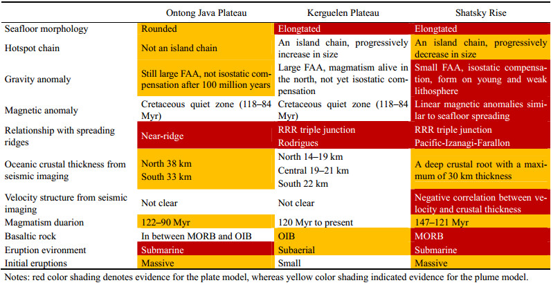
In general, the Ontong Java Plateau, the Kerguelen Plateau and the Shatsky Rise have many differences from each other and only a few are in common. The commonalities incorporate the immense size of volcanoes, rapid eruptions for the main structure and the near-ridge setting during formation. The rest show more or less diversity among the three oceanic plateaus. Statistically, in Table 1, the Ontong Java Plateau and the Shatsky Rise have 4 items in agreement (i.e., > 30 km thick crust, short magmatism duration, submarine eruptions, and massive initial eruptions), which however apparently differ from the Kerguelen Plateau. In contrast, the Kerguelen Plateau and the Shatsky Rise contain 2 items in consent (elongated and island-chain-like morphology), which are clearly different from the Ontong Java Plateau. Additionally, the Ontong Java Plateau and the Kerguelen Plateau demonstrate large gravity anomaly in FAA relative to small on the Shatsky Rise.
4 Implications for Oceanic Plateau FormationMany observations discussed here in the multi-disciplinary subjects of marine geology, geophysics, and geochemistry, show a diverse diagnostication on hypothesized mechanisms (plume or plate) of oceanic plateau formation. Some match the mantle plume predictions, whereas others fit the plate boundary mechanisms (Table 1). Among oceanic plateaus, observations reveal much more discrepancies than commonalities in terms of magmatic and tectonic styles. Even each oceanic plateau itself has contradicting findings in reaching an agreement on either the plume or plate models. Therefore, for the plume or plate hypotheses, neither can provide a 'one-fits-all' solution to incorporate all the observations. It does not nevertheless turn dim in discovering the origin of oceanic plateaus. We can definitely learn further and better from those key observations, and make necessary modification to existing models or propose a hybrid (or even brand new) one to explain the majority of discovery.
It is compelling to begin with the common features found over the three oceanic plateaus. Tremendous dimensions in seafloor morphology and subsurface structure require enormous volcanic output in a short period of geological time, no matter from shallow or deep inside the mantle. Most scientists prefer a mantle plume to produce this anomalous amount of melts (Richards et al., 1989; Mahoney and Spencer, 1991; Coffin and Eodlholm, 1994). In the laboratory, some experiments were successfully conducted to stimulate the diapiric motion of a plume in 3D mantle convection, which includes the unusual flow features of plates and sinking-slabs (Ribe et al., 2007). In addition, people often think that heat flow from Earth's cooling core may be a significant source of energy driving the formation of large deep mantle plumes. From global and regional seismic topography, plumes seem to be visible and broad plumes are rooted at the base of the Earth's mantle beneath major active hotspots at present days, such as Iceland, Hawaii and many other hotspots in the eastern Pacific Ocean (French and Romanowicz, 2015). It is strongly evidenced that hotspots are associated with mantle plumes and result in large volcanic edifices onto the Earth's surface. However, it is not practical now to directly observe the existence of plumes under the Ontong Java Plateau, the Kerguelen Plateau and the Shatsky Rise, because they may have left the plumes for more than a hundred million years.
The Ontong Java Plateau, the Kerguelen Plateau and the Shatsky Rise all appear to be formed at a near-ridge setting, which is increasingly proved to be a common characteristic for oceanic plateaus. Mid-ocean ridges, a triple junction, in particular, are defined as a result of seafloor spreading and plate divergence in the plate boundary theory. A link between ridge process and oceanic plateau formation seems to be inevitable. Several crucial observations are related to ridge process, for example, elongated morphology of the Kerguelen Plateau and the Shatsky Rise, linear magnetic anomalies found across the heart of the Shatsky Rise, and MORB-type basalts drilled from the Shatsky Rise and submarine volcanism on the Ontong Java Plateau and the Shatsky Rise. Implications from these findings are that the formation of oceanic plateaus was controlled by seafloor spreading and surface magma emplacement complied with the mid-ocean ridge pattern.
The plume and plate models are often assumed to work independently. Observations and comparisons of the Ontong Java Plateau, the Kerguelen Plateau and the Shatsky Rise may not allow them to be quite effective solely by themselves. Oceanic plateau usually renders partial support for either model, making it one not be typical of all. Assuming oceanic plateaus sitting on mantle plumes, coincidences with spreading ridges imply a plume-ridge interaction, in which ridge process would have been in a dominating role at least for the surface volcanic expressions. Below the surface, two possible mechanisms may account for the massive melting anomalies. One could be spreading ridges are dragged by a nearby mantle plume and jump to the location of the plume. Subsequently, seafloor spreading occurs atop a mantle plume, outpouring the plume-entrained magma together with the ridge melts. The case of the Shatsky Rise is consistent with this mechanism. Before the Shatsky Rise formation, the Pacific- Izanagi-Farallon ridge-ridge-ridge triple junction is 800 km away. The triple junction then migrated long distance to the location of the Tamu Massif where the initial eruptions of the Shatsky Rise took place. The path of ridge reorganization cannot be explained by plate kinematics, implying something (perhaps mantle plume) drove the triple junction rather than plate motions. Another possibility is that the asthenosphere is fed by mantle plume and cause a local patch of fertile mantle melts. The upper mantle convection pumps this extraordinary magma into the spreading ridges if nearby, making it a swollen ridge. The linear shapes of the Kerguelen Plateau and the Shatsky Rise fit with the idea of swollen ridges.
It is notable that there are significant differences in evolution among the Ontong Java Plateau, the Kerguelen Plateau and the Shatsky Rise. Several odd characteristics need explanations. The Ontong Java Plateau does not have an island chain probably due to the breakup of the Ontong Java-Manihiki-Hikurangi complex by late-stage seafloor spreading (Taylor, 2006), which leaves the Ontong Java Plateau as an isolated volcanic dome. Gravity anomaly signatures in FAA indicate < 30 mGal over the entire Shatsky Rise, implying its formation on a nearly new lithosphere similar to mid-ocean ridges, but the Ontong Java Plateau and the Kerguelen Plateau display obviously large gravity anomaly values. The Kerguelen Plateau is not isostatic compensated owing to its northern portion still has ongoing volcanic activity. The Ontong Java Plateau was created almost a hundred million years ago and it, however, is not yet isostatic compensated. Anomalously thick crust, local dense material inside the plateau body and inadequate subsidence are perhaps responsible for it. Furthermore, the negative correlation of crustal thickness and velocity at Shatsky Rise is interesting (Korenaga and Sager, 2012). A chemical anomalous origin can be inferred from this correlation, not as often assumed a thermal anomaly. Chemical anomaly is theoretically associated with a cold source, recycled crust and passive upwelling (Korenaga et al., 2002; Sallares et al., 2005). Recycled crust from subduction contains eclogite that could lower the solidus of source rock and generate more melts. Moreover, eclogite is considered to be a cause of underwater eruptions and unusual subsidence of Ontong Java Plateau (Korenaga, 2005). The relationship with subduction zones is however unclear according to the so-far knowledge of both the Ontong Java Plateau and the Shatsky Rise. Magmatism is long-lived for the Kerguelen Plateau probably because hotspots (the Kerguelen and Amsterdam-St. Paul hotspots) and mid-ocean ridges (three Indian Ocean ridges) are nearby from then to now, keeping the vitality of the Kerguelen magmatism. Lastly, OIBtype basalts from the Kerguelen Plateau seemingly match with its subaerial volcanism, while MORB-type basalts from the Ontong Java Plateau and the Shatsky Rise are comfortable with their submarine magmatism. The former likely results from melting anomalies at high pressure and temperature and eruptions on pre-existing crust whereas the latter is possibly attributed to relatively low pressure and temperature melting under mid-ocean ridges. The Kerguelen Plateau initiated with small eruptions, unlike the Ontong Java Plateau and the Shatsky Rise, which is likely because the Kerguelen volcanoes were initially formed on a broken continental margin and the pre-existing continental lithosphere may constrain the scale of volcanism. After that, the Kerguelen Plateau became completely oceanic soon and the magmatic output increased to the dimension equivalent to the Ontong Java Plateau and the Shatsky Rise.
5 ConclusionsAs core components of large igneous provinces, the three world's largest oceanic plateaus, the Ontong Java Plateau, the Kerguelen Plateau and the Shatsky Rise, are important indications of extraordinary fluxes of magma from mantle to lithosphere. Detailed description incorporating cross-disciplinary observations on marine geology, geophysics, and geochemistry provide opportunities to test the two popular oceanic plateau formation hypotheses (mantle plume and plate boundary models). Some observations match the plume predictions whereas others fit the plate hypothesis. Hence, it is not a clear differentiation between the plume and plate models. Careful comparisons of the three oceanic plateaus show many commonalities and even more discrepancies in their formation and evolution. This diversity cannot offer a one-fit-all application for oceanic plateau formation. However, several key common features, like massive and rapid eruption and near-ridge formation setting, imply that the lithospheric volcanic emplacement of oceanic plateaus may have been controlled by seafloor spreading in spite of the existence of mantle plume. If a plume exists, it requires a plume-ridge interaction. One proposed mechanism is that a plume draws the neighboring ridge to migrate to the plume location and seafloor subsequently spreads on top of the plume. Another proposal is that the asthenosphere under the spreading ridge is fed by a plume peripherally and produces melting anomalies.
AcknowledgementsThis research was supported by the National Key R & D Program of China (No. 2018YFC0309800), the National Natural Science Foundation of China (Nos. 91628301, U1606401, 41606069, 41776058, 41890813), the Natural Science Foundation of Guangdong Province in China (No. 2017A030313243), the Chinese Academy of Sciences (Nos. Y4SL021001, QYZDY-SSW-DQC005, 133244KY SB20180029), the China Association of Marine Affairs (No. CAMAZD201714), and the Asia-Pacific Economic Cooperation (No. 12119016).
Anderson, D. L., 2005. Large igneous provinces, delamination, and fertile mantle. Elements, 1: 271-275. DOI:10.2113/gselements.1.5.271 (  0) 0) |
Anderson, D. L., Tanimoto, T. and Zhang, Y. S., 1992. Plate tectonics and hotspots: The third dimension. Science, 256: 1645-1651. DOI:10.1126/science.256.5064.1645 ( 0) |
Androvandi, S., Davaille, A., Limare, A., Foucquier, A. and Marais, C., 2011. At least three scales of convection in a mantle with strongly temperature-dependent viscosity. Physics of the Earth and Planetary Interiors, 188: 132-141. DOI:10.1016/j.pepi.2011.07.004 ( 0) |
Benard, F., Callot, J. P., Vially, R., Schmitz, J., Roest, W., Patriat, M., Loubrieu, B. and the ExtraPlac Team,, 2010. The Kerguelen Plateau: Records from a long-living/composite microcontinent. Marine and Petroleum Geology, 27: 633-649. DOI:10.1016/j.marpetgeo.2009.08.011 ( 0) |
Carlson, R. W., 1984. Isotopic constraints on Columbia River flood basalt genesis and the nature of the subcontinental mantle. Geochimica et Cosmochimica Acta, 48(11): 2357-2372. DOI:10.1016/0016-7037(84)90231-X ( 0) |
Coffin, M. F. and Eldholm, O., 1994. Large igneous provinces: Crustal structure, dimensions, and external consequences. Reviews of Geophysics, 321: 1-36. ( 0) |
Coffin, M. F., Pringle, M. S., Duncan, R. A., Gladczenko, T. P., Storey, M., Muller, R. D. and Gahagan, L. A., 2002. Kerguelen hotspot magma output since 130 Ma. Journal of Petrology, 43(7): 1121-1139. DOI:10.1093/petrology/43.7.1121 ( 0) |
Divins, D. L., 2003. NGDC total sediment thickness of the World's oceans and marginal seas. http://www.ngdc.noaa.gov/mgg/sedthick/sedthick.html.
( 0) |
Foulger, G. R., 2007. The 'plate' model for the genesis of melting anomalies. Special Paper of the Geological Society of America, 430: 1. ( 0) |
Fougler, G. R., 2010. Plates vs. Plumes: A Geological Controversy. Wiley-Blackwell Publication, West Sussex, 1-36.
( 0) |
Foulger, G. R., Pritchard, M. J. and Julian, B. R., 2001. The seismic anomaly beneath Iceland extends down to the mantle transition zone and no deeper. Geophysics Journal International, 142: 1-5. ( 0) |
French, S. W. and Romanowicz, B., 2015. Broad plumes rooted at the base of the Earth's mantle beneath major hotspots. Nature, 525: 95-99. DOI:10.1038/nature14876 ( 0) |
Frey, F. A., Coffin, M. F., Wallace, P. J., Weis, D., Zhao, X., Wise Jr, S. W., Wahnert, V., Teagle, D. A. H., Saccocia, P. J., Reusch, D. N., Pringle, M. S., Nicolaysen, K. E., Neal, C. R., Muller, R. D., Moore, C. L., Mahoney, J. J., Keszthelyi, L., Inokuchi, H., Duncan, R. A., Delius, H., Damuth, J. E., Damasceno, D., Coxall, H. K., Borre, M. K., Boehm, F., Barling, J., Arndt, N. T. and Antretter, M., 2000. Origin and evolution of a submarine large igneous province: The Kerguelen Plateau and Broken Ridge, southern Indian Ocean. Earth and Planetary Science Letters, 176(1): 73-89. ( 0) |
Geldmacher, J., Van den Bogaard, P., Heydolph, K. and Hoernle, K., 2014. The age of Earth's largest volcano: Tamu Massif on Shatsky Rise (northwest Pacific Ocean). International Journal of Earth Sciences, 103: 2351-2357. DOI:10.1007/s00531-014-1078-6 ( 0) |
Gladczenko, T. P. and Coffin, M. F., 2001. Kerguelen Plateau crustal structure and basin formation from seismic and gravity data. Journal of Geophysical Research, 106(8): 16583-19601. ( 0) |
Hamilton, W. B., 2013. The closed upper-mantle circulation of plate tectonics. In: Plate Boundary Zones. Stein, S., and Freymueller, J. T., eds., American Geophysical Union, Washington, D. C., 395-410.
( 0) |
Heydolph, K., Murphy, D. T., Geldmacher, J., Romanova, I. V., Greene, A., Hoernle, K., Weis, D. and Mahoney, J., 2014. Plume versus plate origin for the Shatsky Rise oceanic plateau (NW Pacific): Insights from Nd, Pb and Hf isotopes. Lithos, 200-201: 49-63. DOI:10.1016/j.lithos.2014.03.031 ( 0) |
Huang, Y., Sager, W. W., Tominaga, M., Greene, J. A., Zhang, J. and Nakanishi, M., 2018. Magnetic anomaly map of Ori Massif and its implications for oceanic plateau formaion. Earth and Planetary Science Letters, 501: 46-55. DOI:10.1016/j.epsl.2018.08.029 ( 0) |
Ingle, S. and Coffin, M. F., 2004. Impact origin for the greater Ontong Java Plateau?. Earth and Planetary Science Letters, 218(1-2): 123-134. DOI:10.1016/S0012-821X(03)00629-0 ( 0) |
Ito, G. and Clift, P. D., 1998. Subsidence and growth Pacific Cretaceous plateaus. Earth and Planetary Science Letters, 161: 85-100. DOI:10.1016/S0012-821X(98)00139-3 ( 0) |
Kinman, W. S., Neal, C. R., Davidson, J. P. and Font, L., 2009. The dynamics of Kerguelen Plateau magma evolution: New insights from major element, trace element and Sr isotope microanalysis of plagioclase hosted in Elan Bank basalts. Chemical Geology, 264: 247-265. DOI:10.1016/j.chemgeo.2009.03.010 ( 0) |
Korenaga, J., 2005. Why did not the Ontong Java Plateau form subaerially?. Earth and Planetary Science Letters, 234: 385-399. DOI:10.1016/j.epsl.2005.03.011 ( 0) |
Korenaga, J. and Sager, W. W., 2012. Seismic tomography of Shatsky Rise by adaptive importance sampling. Journal of Geophysical Research, 117: 70-83. ( 0) |
Korenaga, J., Kelemen, P. B. and Holbrook, W. S., 2002. Methods for resolving the origin of large igneous provinces from crustal seismology. Journal of Geophysical Research, 107(B9): 1-27. ( 0) |
Li, S. Z., Geldmacher, J., Hauff, F., Garbe-Schönberg, D., Yu, S., Zhao, S. J. and Rausch, S., 2014. Composition and timing of carbonate vein precipitation within the igneous basement of the early Cretaceous Shatsky Rise, NW Pacific. Marine Geology, 357: 321-333. DOI:10.1016/j.margeo.2014.09.046 ( 0) |
Li, S. Z., Yu, S., Suo, Y. H., Wu, T. T., Somerville, I., Sager, W., Li, X. Y., Hui, G. G., Zhang, Y., Zang, Y. B. and Zheng, Q. L., 2016. Orientation of joints and arrangement of solid inclusions in fibrous veins in the Shatsky Rise, NW Pacific: Implications for crack-seal mechanisms and stress fields. Geological Journal, 51(S1): 562-578. ( 0) |
Macdougall, J. D., 1988. Continental Flood Basalts. Springer, Dordrecht, 1-341.
( 0) |
Mahoney, J. J., and Coffin, M. F., 1997. Large Igneous Provinces: Continental, Oceanic, and Planetary Flood Volcanism. American Geophysical Union, Washington, D. C., preface ix.
( 0) |
Mahoney, J. J. and Spencer, K. J., 1991. Isotopic evidence for the origin of the Manihiki and Ontong Java oceanic plateaus. Earth and Planetary Science Letters, 104: 196-210. DOI:10.1016/0012-821X(91)90204-U ( 0) |
Mahoney, J. J., Duncan, R. A., Tejada, M. L. G., Sager, W. W. and Bralower, T. J., 2005. Jurassic–Cretaceous boundary age and mid-ocean-ridge type mantle source for Shatsky Rise. Geology, 33(3): 185-188. ( 0) |
Mahoney, J., Nicollet, C. and Dupuy, C., 1991. Madagascar basalts: Tracking oceanic and continental sources. Earth and Planetary Science Letters, 104(2): 350-363. ( 0) |
Müller, R. D., Sdrolias, M., Gaina, C. and Roest, W. R., 2008. Age, spreading rates, and spreading asymmetry of the world's ocean crust. Geochemistry, Geophysics, Geosystems, 9(4): Q04006. ( 0) |
Nakanishi, M., Sager, W. W. and Klaus, A., 1999. Magnetic lineations within Shatsky Rise, northwest Pacific Ocean: Implications for hot spot-triple junction interaction and oceanic plateau formation. Journal of Geophysical Research: Solid Earth, 104(B4): 7539-7556. DOI:10.1029/1999JB900002 ( 0) |
Neal, C. R., Sager, W. W., Sano, T., and Erba, E., 2015. The Origin, Evolution, and Environmental Impact of Oceanic Large Igneous Provinces. Special Paper 511, Geological Society of America, Boulder, introduction vii.
( 0) |
Operto, S. and Charvis, P., 1995. Kerguelen Plateau: A volcanic passive margin fragment?. Geology, 23(2): 137-140. ( 0) |
Renne, P. R. and Basu, A. R., 1991. Rapid eruption of the siberian traps flood basalts at the Permo-Triassic boundary. Science, 253(5016): 176-179. DOI:10.1126/science.253.5016.176 ( 0) |
Ribe, N., Davaille, A., and Christensen, U. R., 2007. Fluid dynamics of mantle plumes. In: Mantle Plumes: A Multidisciplinary Approach. Ritter, J. R. R., and Christensen, U. R., eds., Springer, Karlsruhe, 1-48.
( 0) |
Richards, M. A., Duncan, R. A. and Courtillot, V. E., 1989. Flood basalts and hot-spot tracks: Plume heads and tails. Science, 246(4926): 103-107. DOI:10.1126/science.246.4926.103 ( 0) |
Ridley, V. A. and Richards, M. A., 2010. Deep crustal structure beneath large igneous provinces and the petrologic evolution of flood basalt. Geochemistry, Geophysics, Geosystems, 11: 35-44. ( 0) |
Rogers, G. C., 1982. Oceanic plateau as meteorite impact signatures. Nature, 299: 341-342. DOI:10.1038/299341a0 ( 0) |
Rotstein, Y., Schaming, M., Schlich, R. and Colwell, J. B., 1990. Basin evolution in oceanic volcanic plateaux: Seismic reflection evidence from the Kerguelen Plateau. Marine and Petroleum Geology, 7: 2-12. DOI:10.1016/0264-8172(90)90051-H ( 0) |
Sager, W. W., Huang, Y., Tominaga, M., Greene, J., Nakanishi, M. and Zhang, J., 2019. Oceanic plateau formation by seafloor spreading implied by Tamu Massif magnetic anomalies. Nature Geoscience, 12: 661-666. DOI:10.1038/s41561-019-0390-y ( 0) |
Sager, W. W., Kim, J., Klaus, A., Nakanishi, M. and Khankishieva, L. M., 1999. Bathymetry of Shatsky Rise, northwest Pacific Ocean: Implications for ocean plateau development at a triple junction. Journal of Geophysical Research: Solid Earth, 104(B4): 7557-7576. DOI:10.1029/1998JB900009 ( 0) |
Sager, W. W., Sano, T. and Geldmacher, J., 2016. Formation and evolution of Shatsky Rise oceanic plateau: Insights from IODP Expedition 324 and recent geophysical cruises. Earth-Science Review, 159: 306-336. DOI:10.1016/j.earscirev.2016.05.011 ( 0) |
Sager, W. W., Sano, T., Geldmacher, J., and the Expedition 324 Scientists, 2010. Proceedings of the Integrated Ocean Drilling Program, Volume 324. Integrated Ocean Drilling Program Management International, Inc., Tokyo, 1-68.
( 0) |
Sager, W. W., Zhang, J., Korenaga, J., Sano, T., Koppers, A. A. P., Mahoney, J. and Widdowson, M., 2013. An immense shield volcano within Shatsky Rise oceanic plateau, northwest Pacific Ocean. Nature Geoscience, 10: 1-6. ( 0) |
Sallares, V., Charvis, P., Flueh, E. R., Bialas, J. and the SALIERI Scientific Party,, 2005. Seismic structure of the Carnegie ridge and the nature of the Galapagos hotspot. Geophysical Journal International, 161: 763-788. DOI:10.1111/j.1365-246X.2005.02592.x ( 0) |
Sandwell, D. T., Müller, R. D., Smith, W. H. F., Garcia, E. and Francis, R., 2014. New global marine gravity model from CryoSat-2 and Jason-1 reveals buried tectonic structure. Science, 346: 65-67. DOI:10.1126/science.1258213 ( 0) |
Saunders, A. D., Fitton, J. G., Kerr, A. C., Norry, M. J., and Kent, R. W., 2013. The North Atlantic igneous province. In: Large Igneous Provinces: Continental, Oceanic, and Planetary Flood Volcanism. Mahoney, J. J., and Coffin, M. F., eds., American Geophysical Union, Washington, D. C., 1-438.
( 0) |
Schaming, M. and Rotstein, Y., 1990. Basement reflectors in the Kerguelen Plateau, south Indian Ocean: Indications for the structure and early history of the plateau. Geological Society of America Bulletin, 102(5): 580-592. DOI:10.1130/0016-7606(1990)102<0580:BRITKP>2.3.CO;2 ( 0) |
Smith, A. D. and Lewis, C., 1999. The planet beyond the plume hypothesis. Earth-Science Reviews, 48(3): 135-182. DOI:10.1016/S0012-8252(99)00049-5 ( 0) |
Subrahmanyam, C. and Chand, S., 2006. Evolution of the passive continental margins of India – A geophysical appraisal. Gondwana Research, 10(1): 167-178. ( 0) |
Taylor, B., 2006. The single largest oceanic plateau: Ontong Java-Manihiki-Hikuangi. Earth and Planetary Science Letters, 241: 372-380. DOI:10.1016/j.epsl.2005.11.049 ( 0) |
Wolfenden, E., Ebinger, C., Yirgu, G., Renne, P. R. and Kelley, S. P., 2005. Evolution of a volcanic rifted margin: Southern Red Sea, Ethiopia. GSA Bulletin, 117(7-8): 846-864. ( 0) |
Zhang, J. and Chen, J., 2017. Geophysical implications for the formation of the Tamu Massif – The Earth's largest single volcano-within the Shatsky Rise in the northwest Pacific Ocean. Science Bulletin, 62: 69-80. DOI:10.1016/j.scib.2016.11.003 ( 0) |
Zhang, J., Sager, W. W. and Durkin, W. J., 2017. Morphology of Shatsky Rise oceanic plateau from high resolution bathymetry. Marine Geophysical Research, 38: 1-17. DOI:10.1007/s11001-017-9308-5 ( 0) |
Zhang, J., Sager, W. W. and Korenaga, J., 2015. The Shatsky Rise oceanic plateau structure from two-dimensional multichannel seismic reflection profiles and implications for oceanic plateau formation. Special Paper of the Geological Society of America, 511: 103-126. ( 0) |
Zhang, J., Sager, W. W. and Korenaga, J., 2016. The seismic Moho structure of Shatsky Rise oceanic plateau, northwest Pacific Ocean. Earth and Planetary Science Letters, 441: 143-154. DOI:10.1016/j.epsl.2016.02.042 ( 0) |