2. 国土资源部古地磁与古构造重建重点实验室, 北京 100081;
3. 首都师范大学资源环境与旅游学院, 北京 100048
2. Key Laboratory of Paleomagnetism and Tectonic Reconstruction of Ministry of Land and Resources, Chinese Academy of Geological Sciences, Beijing 100081, China;
3. College of Resources, Environment and Tourism, Capital Normal University, Beijing 100048, China
0 引言
印度板块与欧亚板块在古近纪时期发生陆陆碰撞以及之后印度板块持续向欧亚板块内部的楔入挤压作用,造成欧亚大陆南缘发生了强烈的构造变形,在青藏高原周缘区域形成了一系列大规模的走滑断裂体系,还形成了现今的世界屋脊青藏高原[1-4]。近30年来,众多地质学家提出印度板块向青藏高原下部的俯冲作用以及欧亚大陆南缘强烈的近南北向地壳挤压变形作用并不是印度大陆与欧亚大陆之间南北向大规模地壳缩短的唯一主导因素[5],青藏高原东南缘众多拼贴地壳块体沿大型左旋走滑断裂带发生的东南侧向旋转挤出逃逸作用同样也可能吸收欧亚大陆南缘巨大的南北向地壳缩短量[3, 5-7]。因此,青藏高原南缘主要拼贴地块新生代时期是否存在大规模侧向挤出逃逸过程是解决青藏高原隆升过程、欧亚大陆地壳构造变形等众多科学问题的关键所在[3, 5, 7-8]
青藏高原东南缘主要由腾冲地体、保山地体、临沧花岗岩带、思茅地体以及川滇地体等多个地质构造单元组成,不同块体间以大型走滑断裂带为界。高黎贡山右旋走滑断裂分割腾冲与保山地体,澜沧江断裂带位于临沧—勐连花岗岩带东侧,形成了保山地体与思茅地体的分界线,而哀牢山—红河走滑断裂带则切开思茅地体与川滇地体 (图 1)。印度板块与欧亚板块碰撞过程和其后二者强烈的南北向挤压作用导致了青藏高原东南缘区域极为发育的褶皱体系及大型走滑断裂体系,并发育了大量的白垩纪和古近纪断陷盆地和陆相红层沉积,是古地磁学研究青藏高原物质是否存在侧向挤出逃逸运动的最佳区域。前人在思茅地体白垩纪和新生代地层中开展了众多古地磁研究[10-16]。这些古地磁研究主要集中于思茅地体北部的兰坪、云龙、永平等地[10-11, 13-14],中部的普洱、景谷[15]以及南部的江城和勐腊等地[17-18]。这些以白垩纪红层为主的结果表明,思茅地体在发生整体性东南侧向顺时针旋转挤出运动的同时,还发生极为强烈的陆内差异性旋转变形作用[8, 10-12, 17, 19-22]。近20年来,在青藏高原南部及东缘区域进行的GPS监测研究也表明,青藏高原内部和周缘地区地壳物质近似以东喜马拉雅构造结为中心,发生明显的顺时针旋转运动[23-24]。
由于东亚地区白垩纪和古近纪红层中赤铁矿携磁矿物可能存在压实作用造成的磁倾角偏低现象[25],且思茅地体古近纪红层还缺少详细的磁倾角可靠性研究,制约了其对东南侧向挤出量的深入分析。Tong等[17]在思茅地体南部孟仑、勐伴和勐腊地区白垩纪和新生代地层中进行了构造古地磁研究,考虑了这些红层可能存在磁倾角偏低现象,并对古近纪古地磁数据进行了E/I校正[26],估算思茅地体可能超过1 000 km的南向位移,远远大于其他位移估算量。因此,E/I磁倾角偏低校正方法是否存在问题值得进一步研究。本次研究在Tong等[17]的采样剖面再次采集样品,利用Hodych等[27]提出的磁倾角校正方法重新研究思茅地体东南部勐腊地区地层的磁倾角偏低现象,并对该剖面的数据重新进行E/I校正[26],以分析E/I磁倾角偏低校正方法[26]的适用范围和可靠性。并由此估算思茅地体古近纪以来受印度板块和欧亚板块碰撞以及持续挤压作用而发生了南向逃逸量。
1 地质背景与采样思茅地体位于青藏高原东南部,属于印度支那地块的北部,其东北侧边界为北西—南东走向的金沙江断裂带和哀牢山-红河走滑断裂带[28],哀牢山-红河走滑断裂带为华南与印支地块的分界线。思茅地体西南侧边界为崇山剪切带和澜沧江断裂带。前人研究表明红河走滑断裂带自渐新世末期开始发生大规模左旋走滑运动[9, 29-32],自上新世开始 (~5 Ma) 红河走滑断裂带走滑性质转变为右旋走滑运动[7]。
思茅地体内部广泛出露白垩纪至古近纪陆相沉积地层。古近纪时期受印度与欧亚板块的碰撞以及两者持续的近北北东向挤压作用,思茅地体内部白垩纪至古近纪时期的陆相沉积地层广泛发育褶皱轴向近北西-南东向的褶皱系和近北西向伸展的逆冲断裂系[33-34]。
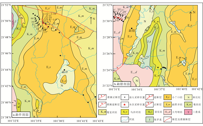
勐腊县位于思茅地体东南缘,距哀牢山-红河走滑断裂西约200 km,其北临普洱县,东、南、西三面与老挝接壤。勐腊地区白垩纪与古新世、始新世陆相红层地层广泛出露[33]。该地区古新世和始新世红层地层普遍发育轴向近南北的褶皱。我们在Tong等[17]的采样剖面中采集了38块以地层层面为参考面的定向手标本。其中,勐伴 (MBD) 剖面 (21.8°N,101.6°E) 位于勐伴镇西北部,为始新世小丫口组,岩性主要为红色中砂岩、细砂岩、粉砂岩,采集定向手表本16块;勐腊 (MAD) 剖面 (21.5°N,101.5°E) 位于勐腊县城的西北 (图 2),主要为始新世大弯塘组,岩性主要为红色中砂岩、细砂岩、粉砂岩,共设置7个采点,采集手表本22块。每个采点采集3~4块定向手标本,所有样品均用GPS进行定位,并经2010年国际参考地磁场[35]对采样区现代地磁场磁偏角进行校正。
在室内从每块定向手标本上钻取两根以上岩心,并加工出多块长2.2 cm、直径2.5 cm的标准岩心样品。每根岩心选取至少一块标准样品进行系统热退磁实验,并与Tong等[17]在同一条采样剖面中得到的原生特征剩磁方向进行比对,其余样品用于Hodych等[27]磁倾角偏低校正实验。少部分样品仅能加工出一块样品,因此优先进行磁倾角偏低校正实验。所有实验工作均在中国地质科学院地质力学研究所国土资源部古地磁与古构造重建重点实验室完成。样品系统热退磁由TD-48大型热退磁仪完成,样品剩磁测量在2G-755超导磁力仪上完成。
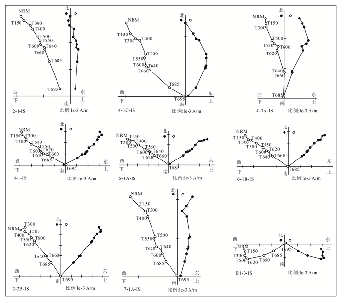
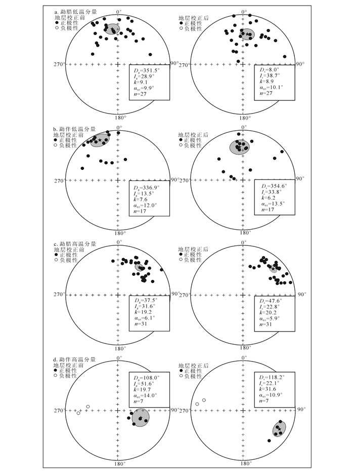
本次磁倾角偏低标本采点与Tong等[17]古地磁采样剖面中的采点位置完全对应,岩性和地层层位基本相同。Tong等[17]岩石磁学实验结果显示地层剖面主要载磁矿物为赤铁矿。因此系统热退磁温度区间在低温段以50~100 ℃为间隔,高温段以10~20 ℃为间隔,最高热退磁温度为695 ℃。样品使用主向量分析法进行剩磁组分分析[36](图 3),最后以样品为单位进行Fisher统计[37] (图 4)。
|
| 空心圆代表磁倾角;实心圆代表磁偏角。 图 3 代表性样品的热退磁Z矢量图 Figure 3 Zijderveld diagrams of thermal demagnetizations results for the representive samples |
|
|
|
| 图 4 各剖面特征剩磁磁化方向的等面积投影图 Figure 4 Equal-area projection of characteristic component from each section |
|
|
中晚始新世的大弯塘组 (E2-3d) 勐腊剖面样品根据热退磁特点分为两类:第一类样品 (如B1-3) 分离出2个剩磁组分,低温分量加热至300 ℃左右可分离出,从27块中得到了低温磁化分量,其平均方向在地层校正前为: Dg=351.5°, Ig=28.9°, k=9.1, α95=9.9°, 与当地现代地磁场方向一致,地层校正后为:Ds=8.0°, Is=38.7°, k=8.9, α95=10.1°, 未通过褶皱检验且与采样剖面现代地磁场方向 (D=358.8°, I=31.4°) 基本一致,因此应该为近代形成的黏滞剩磁 (图 4a)。高温分量加热至695 ℃时分离出来。第二类样品 (如6-1B) 为单磁组分分量,加热至695 ℃时分离出高温磁化分量。
两类样品中共有31块样品获得高温磁化分量 (表 1),由于样品位置相差不远,且时代一致,所以将所有样品一起平均,平均后的方向在地层校正前为:Dg=37.5°, Ig=31.6°, k=19.2, α95=6.1°, 地层校正后为:Ds=47.6°, Is=22.8°, k=20.2, α95=5.9°(图 4c), 该结果与Tong等[17]同一地层的结果基本一致。因此,该高温分量与Tong等[17]的结果一样,可视为原生剩磁。
| 剖面 | 采样点 | 纬度/经度 | 样品数 | Dg(°)/Ig(°) | Ds(°)/Is(°) | α95/(°) | 右手走向 (°)/倾角 (°) |
| 勐腊 | MAD1 | 21°30′7.2″N/101°32′17.7″E | 2 | 72.3/9.1 | 13.6/54.7 | — | 198/82 |
| MAD2 | 21°30′12.1″N/101°32′5.0″E | 7 | 30.3/33.0 | 45.8/18.9 | 25.7 | 15/31 | |
| MAD3 | 21°30′13.8″N/101°31′54.4″E | 2 | 31.1/37.9 | 47.2/25.7 | — | 14/28 | |
| MAD4 | 21°30′13.5″N/101°31′51.8″E | 7 | 38.3/33.5 | 52.1/24.0 | 24.4 | 25/27 | |
| MAD5 | 21°30′13.5″N/101°31′51.8″E | 4 | 35.8/25.6 | 46.6/18.2 | 8.9 | 19/30 | |
| MAD6 | 21°30′19.5″N/101°31′31.8″E | 7 | 44.6/34.0 | 52.7/25.4 | 20.3 | 10/7 | |
| MAD7 | 21°30′23.7″N/101°31′10.8″E | 2 | 31.7/30.0 | 36.4/19.0 | — | 347/15 | |
| 平均值 | 37.5/31.6 | 47.6/22.8 | 5.9 | ||||
| 勐伴 | MBD1-1 | 21°49′15.2″N/101°36′28.9″E | 1 | 266.0/-25.7 | 278.4/-12.4 | — | 72/37 |
| MBD1-2 | 21°49′15.2″N/101°36′28.9″E | 2 | 120.6/54.4 | 133.7/22.8 | — | 64/35 | |
| MBD1-3 | 21°49′15.2″N/101°36′28.9″E | 1 | 110.8/41.7 | 122.2/16.3 | — | 65/32 | |
| MBD1-6 | 21°49′22.2″N/101°36′26.7″E | 2 | 113.5/68.9 | 112.0/26.9 | — | 21/42 | |
| MBD1-9 | 21°49′15.2″N/101°36′28.9″E | 1 | 277.9/-42.2 | 285/-23.5 | — | 44/22 | |
| 平均值 | 108.0/51.6 | 118.2/22.1 | 10.9 | ||||
| 注:为保证数据可靠性,对手标本取出样品数≤2的精度不做统计,所有的样品分两个剖面统一进行平均。 | |||||||
根据热退磁结果将勐伴始新世小丫口组 (E2x) 样品分为两类:第一类为双分量样品 (如2-2B),在20~300 ℃分离出低温磁化分量。共有17块标准样品分离出低温磁化分量,其地层校正前平均方向为: Dg=336.9°, Ig=13.5°, k=7.6, α95=12.0°, 地层校正后为:Ds=354.6°, Is=33.8°, k=6.2, α95=13.5 °, 其平均方向未通过褶皱检验 (图 4b)。第二类样品为单剩磁分量 (如6-1A),系统热退磁温度在达到695 ℃时分离出高温磁化分量。
两类样品中共有7块样品得到了高温磁化分量 (表 1),平均方向在地层校正前为:Dg=108.0°, Ig=51.6°, k=19.7, α95=14.0°, 地层校正后为:Ds=118.2°, Is=22.1°, k=31.6, α95=10.9°(图 4d)。该结果与Tong等[17]始新世小丫口组舍弃的7个采点位置相同,其得出的高温分量地层校正后为:Ds=119.6°,Is=26.8°,k=21.3, α95=13.4°,我们的结果与Tong等[17]结果在误差范围内一致。由于Tong等[17]结果通过了褶皱检验,所以,我们认为该高温分量与Tong等[17]的结果一样同为原生剩磁。
3 磁倾角偏低校正结果 3.1 E/I磁倾角偏低校正近年来,红层沉积后压实作用所导致的磁倾角偏低现象越来越受到地质学家的重视[26, 38-44]。以往思茅地体内部白垩纪和古近纪地层中的古地磁研究大都没有进行任何磁倾角偏低校正分析[10-15],Tong等[17]通过勐腊和勐伴地区白垩纪和古近纪数据的对比,提出思茅地体东南部古近纪红层可能存在磁倾角偏低现象,通过E/I磁倾角偏低校正后[43]实测磁倾角为23.6°,校正倾角为44.1°[38.3°,49.3°],提出沉积压实作用导致古近纪地层发生约20.5°磁倾角浅化作用。选取前人在华南地块同时期的平均古地磁结果为参考极,通过磁倾角校正后的结果计算得出勐腊地区自古近纪以来相对于华南发生1 000 km以上的南向运移,明显大于其他地质学的研究结果[30, 45]。
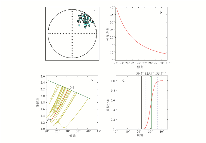
仔细分析Tong等[17]勐腊-勐伴剖面剩磁方向等面积投影图可以看出,其磁偏角分布显示较明显的伸展变化,这种变化可能与沉积压实作用造成的磁倾角变化有关,或者与剖面内局部范围差异性构造旋转变形有关,两者有时难以区别。本研究结果可以看出,两个相邻剖面的平均磁偏角可以有显著差异,我们怀疑剖面内的局部变形可能造成剖面的磁偏角较分散,对Tong等[17]勐腊-勐伴剖面采点进行重新分析,去除地层产状明显不一致的采样点数据,且将地层产状较为一致的古地磁学数据统一为正向极性,再次进行E/I磁倾角偏低校正,以排除局部采点受变形作用对磁偏角的影响,重新开展的E/I磁倾角校正结果见图 5,校正后的磁倾角Is=30.7° [25.4°,35.9°]。
|
| a.古地磁方向;b.伸展方向相对于倾角的变化曲线 (根据每个样品的3个方向轴计算得出);c.伸展率/倾角关于f的函数 (其中绿线为TK03.GAD模型模拟的,红线为本次采点数据;图中同时还列出了20套运用“解靴带”法计算的数据结果,交叉点代表伸展率-磁倾角值与TK03.GAD模型模拟值最吻合的地方);d.校正倾角的累计分布 (1 000套“解靴带”法数据交叉点绘制的累计分布图)。 图 5 勐腊-勐伴剖面古地磁数据的E/I校正结果 Figure 5 Results of E/I (elongation-inclination) correction from Mengla-Mengban section |
|
|
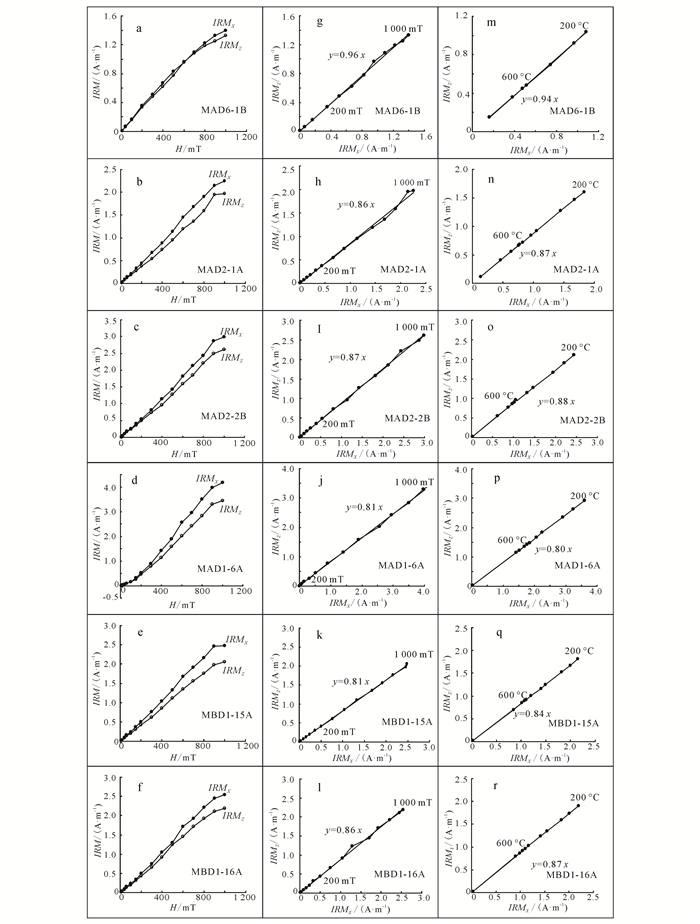
Tong等[17]的岩石磁学实验显示勐腊剖面和勐伴剖面始新世红层的载磁矿物为赤铁矿,因此我们采用Hodych等的磁倾角校正方法[27]对始新世红层磁倾角进行分析。首先在样品X轴和Z轴之间45°方向分步骤施加直流磁场,保证X轴与Z轴能够施加同样大小的直流磁场,直流磁场大小由10,20,40,60,100,200,300,400,600,800,1 000 mT依次递增。在每步施加直流场后使用美制2G-755型超导磁力仪和JR6旋转磁力仪对样品进行剩磁测试。当外加直接场强达到1 000 mT之后,使用美制2G-755型超导磁力仪、JR6旋转磁力仪以及TD48大型热退磁炉对所有样品进行系统热退磁。低温加热温度间隔较大,在热退磁温度达到600~685 ℃时以15~20 ℃为间隔,共计13步开展系统退磁测试。IRMZ及IRMX分别代表垂直层面和平行层面的等温剩磁强度。图 6显示在加正向直流磁场过程中,所有测试样品的IRMX明显大于IRMZ,IRMZ/IRMX=0.88。由于所有样品载磁矿物主要为赤铁矿,因此,IRMZ和IRMX的值分别选取系统热退磁实验中温度在600~685 ℃之间分量,计算IRMZ/IRMX=0.89。结果显示所加外部直流场在200~1 000 mT的IRMZ/IRMX与系统热退磁温度在600~685 ℃的IRMZ/IRMX结果极为接近。由于沉积压实作用与沉积物粒度的大小有关,沉积物粒度越细,越容易产生沉积压实作用[46],为了保证磁倾角偏低校正的准确性,只将红色、砖红色粉砂岩的IRMZ/IRMX结果进行校正分析。
|
| a-f.以45°角逐步递增外加磁场过程;g-l.外加磁场强度10~1 000 mT过程;m-r.热退磁过程中,600~685 ℃过程。 图 6 IRMX和IRMZ对比图 Figure 6 Comparison diagram of IRMX(parallel to bedding) and IRMZ (perpendicular to bedding) |
|
|
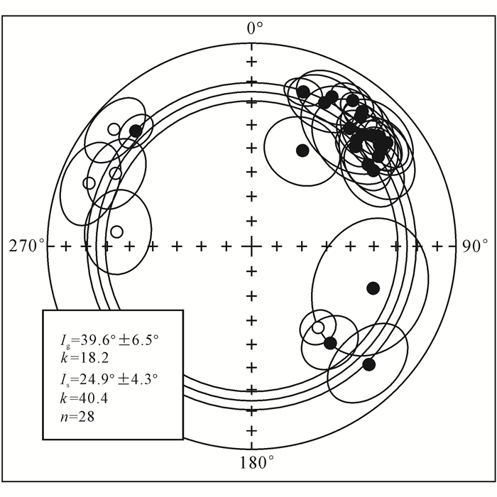
本次采样剖面选自Tong等[17]的采样剖面,采样地层层位明确,虽然Tong等[17]的数据显示勐伴小丫口组发生了局部差异性旋转变形运动,但其剖面平均磁倾角 (Is=26.8°±13.4°) 与本次研究在误差范围内基本一致 (Is=22.1°±10.9°)。因此,为了提高研究区始新世地层磁倾角数据的可靠性,将Tong等[17]受到局部旋转作用影响的勐伴小丫口组数据与勐腊剖面一起进行磁倾角统计平均,得出勐腊-勐伴地区古近纪时期平均磁倾角方向 (图 7)。其地层校正后平均方向为:Is=24.9°±4.3°, k=40.4。磁倾角偏低实验结果获得采样剖面粉砂岩样品系统热退磁高温区间 (600~685 ℃) 的IRMZ/IRMX拟合线平均值为0.859(表 2),通过公式IRMZ/IRMX=tan (实测)/tan (推算结果) 进行校正后得到研究区古近纪时期磁倾角为28.4°,其在系统误差范围内与通过E/I磁倾角校正方法得到的结果基本一致。
|
| 图 7 勐腊-勐伴剖面采样地层磁倾角平均结果 Figure 7 Inclination-mean result of the Mengla-Mengban section |
|
|
| 剖面 | 样品名 | 纬度/经度 | 测量等温剩磁各 向异性的样品数 |
IRMZ/IRMX | 岩性 | |
| 200~1 000 mT | 600~685 ℃ | |||||
| 勐腊 早始新世 (E1) |
MAD2-3A | 21°30′12.1″N/101°32′5.0″E | 1 | 0.900 | 0.885 | 砖红色中砂岩 |
| MAD6-1 | 21°30′19.5″N/101°31′31.8″E | 1 | 0.821 | 0.911 | 砖红色中砂岩 | |
| MAD6-1A | 21°30′19.5″N/101°31′31.8″E | 1 | 0.984 | 1.000 | 砖红色中砂岩 | |
| MAD6-1B | 21°30′19.5″N/101°31′31.8″E | 1 | 0.965 | 0.940 | 砖红色中砂岩 | |
| MAD6-1C | 21°30′19.5″N/101°31′31.8″E | 1 | 0.903 | 0.892 | 砖红色中砂岩 | |
| 平均值 | 0.915 | 0.926 | ||||
| MAD2-1 | 21°30′12.1″N/101°32′5.0″E | 1 | 0.940 | 0.972 | 砖红色细砂岩 | |
| MAD2-1A | 21°30′12.1″N/101°32′5.0″E | 1 | 0.862 | 0.877 | 砖红色细砂岩 | |
| MAD4-1A | 21°30′13.5″N/101°31′51.8″E | 1 | 0.874 | 0.887 | 砖红色细砂岩 | |
| MAD4-1B | 21°30′13.5″N/101°31′51.8″E | 1 | 0.998 | 1.010 | 砖红色细砂岩 | |
| MAD4-1C | 21°30′13.5″N/101°31′51.8″E | 1 | 0.919 | 0.905 | 砖红色细砂岩 | |
| 平均值 | 0.919 | 0.930 | ||||
| MAD1-3B | 21°30′7.2″N/101°32′17.7″E | 1 | 0.870 | 0.841 | 砖红色粉砂岩 | |
| MAD2-2B | 21°30′12.1″N/101°32′5.0″E | 1 | 0.872 | 0.888 | 砖红色粉砂岩 | |
| MAD4-2A | 21°30′13.5″N/101°31′51.8″E | 1 | 0.865 | 0.877 | 砖红色粉砂岩 | |
| MAD4-4A | 21°30′13.5″N/101°31′51.8″E | 1 | 0.891 | 0.891 | 砖红色粉砂岩 | |
| MAD4-3B | 21°30′13.5″N/101°31′51.8″E | 1 | 0.822 | 0.835 | 砖红色粉砂岩 | |
| MAD4-3C | 21°30′13.5″N/101°31′51.8″E | 1 | 0.840 | 0.818 | 砖红色粉砂岩 | |
| 平均值 | 0.860 | 0.858 | ||||
| 平均值 (勐腊样品) | 0.895 | 0.902 | ||||
| 勐伴 中晚始新世 (E2-3) |
MBD1-6A | 21°49′22.2″N/101°36′26.7″E | 1 | 0.813 | 0.814 | 砖红色粉砂岩 |
| MBD1-14A | 21°50′19.3″N/101°35′31.5″E | 1 | 0.900 | 0.890 | 砖红色粉砂岩 | |
| MBD1-14B | 21°50′19.3″N/101°35′31.5″E | 1 | 0.808 | 0.870 | 砖红色粉砂岩 | |
| MBD1-15A | 21°50′19.3″N/101°35′31.5″E | 1 | 0.815 | 0.835 | 砖红色粉砂岩 | |
| MBD1-15B | 21°50′19.3″N/101°35′31.5″E | 1 | 0.863 | 0.825 | 砖红色粉砂岩 | |
| MBD1-16A | 21°50′19.3″N/101°35′31.5″E | 1 | 0.868 | 0.874 | 砖红色粉砂岩 | |
| MBD1-16B | 21°50′19.3″N/101°35′31.5″E | 1 | 0.853 | 0.863 | 砖红色粉砂岩 | |
| MBD1-16C | 21°50′19.3″N/101°35′31.5″E | 1 | 0.911 | 0.903 | 砖红色粉砂岩 | |
| 平均值 (勐伴样品) | 0.854 | 0.859 | ||||
| 注:14件勐腊-勐伴粉砂岩的IRMZ/IRMX平均值,在200~1 000 mT时为0.857, 在600~685 ℃时为0.859。 | ||||||
关于红层地层沉积物粒度大小与磁倾角变化关系目前有3种截然不同的主流观点:1) 黏土沉积物中存在磁倾角偏低现象,但是粗颗粒的沉积物中没有磁倾角偏低现象;2) 粗颗粒沉积物中有磁倾角偏低现象,但是细粒沉积物中没有磁倾角偏低现象;3) 粗颗粒沉积物和细颗粒沉积物中有着相似程度的磁倾角偏低现象。有研究证实黏土质沉积地层中的赤铁矿发生了大角度的磁倾角偏低现象[46]。但是其他研究却发现中细粒磁性矿物较准确地记录了地磁场的方向,而并没有发生磁倾角偏低,而粗颗粒沉积地层中发生了较大的磁倾角偏低现象[47-48]。因此,Tauxe等[49]提出了另外一种观点,含粗粒和细粒赤铁矿沉积地层中都出现了磁倾角偏低,但沉积物的粒度和磁倾角的变化之间没有明显的关联。
本文磁倾角偏低校正结果显示 (图 6),图 6a为中砂岩,图 6b为细砂岩,图 6c-f为粉砂岩,随着沉积粒度由粗变细,IRMX与IRMZ的差值由小增大,即随着沉积物粒度由粗变细,红层的磁倾角偏低更为明显。虽然红层沉积物粒度对磁倾角的影响还存争议,但是利用Hodych等[27]及E/I方法[26]进行磁倾角校正分析表明,勐腊和勐伴剖面古近纪地层的细颗粒样品其磁倾角偏低现象更为明显。
4 思茅地体古近纪侧向旋转挤出运动Tapponnier等[5]提出印-亚碰撞后印度板块持续向北的挤压而导致印支地块发生了侧向挤出,已获得大量构造地质和古地磁研究的支持[10-18, 30],数十年来青藏高原南部及周缘区域GPS监测研究也呈现南移变形特征[23-24, 50]。然而,印支地块发育大量北西—南东走向走滑断裂等变形体系,使不同研究区表现出差异性旋转[17]。前人利用古地磁数据对思茅地体的南向运移量进行过系统的估算,提出白垩纪以来印支地块向南滑移量达500~1 000 km[15, 19, 21, 51],这些估算量绝大多数来自白垩纪数据,地质年代学研究表明哀牢山—红河大型走滑断裂带的活动始于渐新世[30, 45, 52-55],显然该地体古近纪古地磁数据也应反映出其南向运移量,思茅地体内部古近纪古地磁数据是否存在磁倾角偏低至关重要。本文通过不同方法校正古近纪地层的磁倾角偏低问题,对比Cogné等[56]建立的东亚地区始新世的视极移曲线,获得勐腊-勐伴研究区始新世以来的纬向位移量为-2.8°±5.0°。若选取前人[18]在华南地块获得的高质量古地磁学数据,重新计算华南地块始新世的古地磁极 (表 3), 以华南地块始新世古地磁极为参考极,计算获得勐腊-勐伴地区自始新世以来的南向运移量为-4.2°±5.4°。尽管南向位移量仍存在较大误差,但该结果与张海峰等[18]依据白垩纪数据推测地块南向位移量-5.2°±2.8°相比,这些结果均表明思茅地块在始新世之后相对于华南地块应存在南向运移量可达450±600 km,与哀牢山—红河断裂带内推测的左旋走滑位移量基本一致[30, 45, 65]。
| 位置 | 岩性 | 采点数 (样品数) |
采样位置 (N°/E°) |
VGP 极位置 (N°/E°) |
α95/(°) | 褶皱检验 | 参考文献 |
| 广西右江盆地 | 红层 | 1(17) | 23.5/107.2 | 58.6/18.2 | 7.4 | 通过 | [58] |
| 广西青秀山和五象岭 | 淡黄色砂岩 | 5(31) | 22.7/108.3 | 83.8/236.0 | 4.3 | 通过 | [59] |
| 湖南衡阳盆地 | 红层 | 19 | 27.0/112.0 | 73.6/256.4 | 5.6 | 倒转检验 | [60] |
| 湖南衡阳盆地 | 红层 | 22(145) | 26.9/112.6 | 82.6/300.7 | 4.4 | 倒转检验 | [61] |
| 湖南衡阳盆地 | 红层 | 5 | 27.0/ 112.5 | 76.8/243.9 | 7.8 | 通过 | [62] |
| 安徽 | 红层 | (18) | 30.6/116.8 | 80.1/238.5 | 7.7 | 通过 | [63] |
| 江西 | 红层 | 73 | 25.5/114.5 | 72.4/248.3 | 3.5 | 通过 | [64] |
| 平均值 | 78.8/247.5 | 5.9 | |||||
| 注:该平均值为先将每个省份的数据平均,再对4个省份的平均值进行平均。表中数据来源于文献[57]。 | |||||||
1) 思茅地体勐腊-勐伴剖面的磁倾角校正表明,利用E/I法进行校正应充分考虑剖面内局部构造变形的影响,以免造成校正过度现象,在此前提下进行的E/I磁倾角偏低校正可以获得较可靠的结果。
2) 利用Hodych等磁倾角校正方法检验沉积物颗粒大小对磁倾角偏低的影响,结果表明研究区颗粒更细的岩性,磁倾角偏低的现象更加明显,两种方法的相互验证,可以提高磁倾角校正值的可信度。
3) 如果思茅地体在白垩纪与始新世之间没有发生明显的纬向运移,思茅地体始新世后相对于华南地块发生了450±600 km的南向运移量,该推测值与从哀牢山红河断裂带内其他地质证据获得的断裂带左旋走滑位移量基本一致。
| [1] | Molnar P, Tapponnier P. Cenozoic Tectonics of Asia:Effects of a Continental Collision[J]. Science, 1975, 189(4201): 419-426. DOI:10.1126/science.189.4201.419 |
| [2] | Rowley D B. Age of Initiation of Collision Between India and Asia:A Review of Stratigraphic Data[J]. Earth and Planetary Science Letters, 1996, 145(1): 1-13. |
| [3] | Tapponnier P, Zhiqin X, Roger F, et al. Oblique Stepwise Rise and Growth of the Tibet Plateau[J]. Science, 2001, 294(5547): 1671-1677. DOI:10.1126/science.105978 |
| [4] | Tong Y B, Yang Z Y, Zheng L D, et al. Early Paleocene Paleomagnetic Results from Southern Tibet, and Tectonic Implications[J]. International Geology Review, 2008, 50(6): 546-562. DOI:10.2747/0020-6814.50.6.546 |
| [5] | Tapponnier P, Molnar P. Slip-Line Field Theory and Large-Scale Continental Tectonics[J]. Nature, 1976, 264(5584): 319-324. DOI:10.1038/264319a0 |
| [6] | Tapponnier P, Peltzer G, Le Dain A Y, et al. Pro-pagating Extrusion Tectonics in Asia:New Insights from Simple Experiments with Plasticine[J]. Geology, 1982, 10(12): 611-616. DOI:10.1130/0091-7613(1982)10<611:PETIAN>2.0.CO;2 |
| [7] | Replumaz A, Tapponnier P. Reconstruction of the De-formed Collision Zone Between India and Asia by Backward Motion of Lithospheric Blocks[J]. Journal of Geophysical Research, 2003, 108(B6): 2285-2308. |
| [8] | 杨振宇, BesseJ, 孙知明, 等. 印度支那地块第三纪构造滑移与青藏高原岩石圈构造演化[J]. 地质学报, 1998, 72(2): 112-125. Yang Zhenyu, Besse J, Sun Zhiming, et al. Tertiary Squeeze-Out of the Indo-China Block and Lithospheric Evolution of the Qinghai-Tibetan Plateau[J]. Acta Geologica Sinica, 1998, 72(2): 112-125. |
| [9] | Gilley L D, Harrison T M, Leloup P H, et al. Direct Dating of Left-Lateral Deformation Along the Red River Shear Zone, China and Vietnam[J]. Journal of Geophysical Research, 2003, 108(B2): 2127-2140. |
| [10] | Sato K, Liu Y Y, Zhu Z C, et al. Paleomagnetic Study of Middle Cretaceous Rocks from Yunlong, Western Yunnan, China:Evidence of Southward Displacement of Indochina[J]. Earth and Planetary Science Letters, 1999, 165(1): 1-15. DOI:10.1016/S0012-821X(98)00257-X |
| [11] | Funahara S, Nishiwaki N, Murata F, et al. Clock-wise Rotation of the Red River Fault Inferred from Paleomagnetic Study of Cretaceous Rocks in the Shan-Thai-Malay Block of Western Yunnan, China[J]. Earth and Planetary Science Letters, 1993, 117(1): 29-42. |
| [12] | Huang K N, Opdyke N D. Paleomagnetic Results from Cretaceous and Jurassic Rocks of South and Southwest Yunnan:Evidence for Large Clockwise Rotations in the Indochina and Shan-Thai-Malay Terranes[J]. Earth and Planetary Science Letters, 1993, 117(3): 507-524. |
| [13] | Chen H H, Dobson J, Heller F, et al. Paleomagnetic Evidence for Clockwise Rotation of the Simao Region Since the Cretaceous:A Consequence of India-Asia Collision[J]. Earth and Planetary Science Letters, 1995, 134(1): 203-217. |
| [14] | Yang Z Y, Yin J Y, Sun Z M, et al. Discrepant Cretaceous Paleomagnetic Poles Between Eastern China and Indochina:A Consequence of the Extrusion of Indochina[J]. Tectonophysics, 2001, 334(2): 101-113. DOI:10.1016/S0040-1951(01)00061-0 |
| [15] | Sato K, Liu Y Y, Wang Y B, et al. Paleomagnetic Study of Cretaceous Rocks from Pu'er, Western Yunnan, China:Evidence of Internal Deformation of the Indochina Block[J]. Earth and Planetary Science Letters, 2007, 258(1): 1-15. |
| [16] | 杨振宇, 孙知明, 马醒华, 等. 红河断裂两侧早第三纪古地磁研究及其地质意义[J]. 地质学报, 2001, 75(1): 35-44. Yang Zhenyu, Sun Zhiming, Ma Xinghua, et al. Palaeomagnetic Study of the Early Tertiary on both Sides of the Red River Fault and Its Geological Implications[J]. Acta Geologica Sinica, 2001, 75(1): 35-44. |
| [17] | Tong Y B, Yang Z Y, Zheng L D, et al. Internal Crustal Deformation in the Northern Part of Shan-Thai Block:New Evidence from Paleomagnetic Results of Cretaceous and Paleogene Redbeds[J]. Tectonophysics, 2013, 608: 1138-1158. DOI:10.1016/j.tecto.2013.06.031 |
| [18] | 张海峰, 仝亚博, 王恒, 等. 印支地块思茅地区早白垩世古地磁结果及其构造意义[J]. 地质学报, 2012, 86(6): 923-939. Zhang Haifeng, Tong Yabo, Wang Heng, et al. Early Cretaceous Paleomagnetic Results of the Simao Area in the Indochina Block and Its Tectonic Implications[J]. Acta Geologica Sinica, 2012, 86(6): 923-939. |
| [19] | Tanaka K, Mu C, Sato K, et al. Tectonic Defor-mation Around the Eastern Himalayan Syntaxis:Constraints from the Cretaceous Palaeomagnetic Data of the Shan-Thai Block[J]. Geophysical Journal International, 2008, 175(2): 713-728. DOI:10.1111/gji.2008.175.issue-2 |
| [20] | Sato K, Liu Y Y, Zhu Z C, et al. Tertiary Paleo-magnetic Data from Northwestern Yunnan, China:Further Evidence for Large Clockwise Rotation of the Indochina Block and Its Tectonic Implications[J]. Earth and Planetary Science Letters, 2001, 185(1): 185-198. |
| [21] | Yang Z Y, Besse J. Paleomagnetic Study of Permian and Mesozoic Sedimentary Rocks from Northern Thailand Supports the Extrusion Model for Indochina[J]. Earth and Planetary Science Letters, 1993, 117(3): 525-552. |
| [22] | Yang Z Y, Sun Z M, Ma X H, et al. The Extrusion of Indochina During the India/Eurasia Collision:Early Tertiary Paleomagnetic Constraints[J]. Gondwana Research, 2001, 4(4): 843. |
| [23] | Zhang P Z, Shen Z K, Wang M, et al. Continuous Deformation of the Tibetan Plateau from Global Positioning System Data[J]. Geology, 2004, 32(9): 809-812. DOI:10.1130/G20554.1 |
| [24] | Shen Z K, Lü J N, Wang M, et al. Contemporary Crustal Deformation Around the Southeast Borderland of the Tibetan Plateau[J]. Journal of Geophysical Research, 2005, 110(B11): 409-425. |
| [25] | Wang B, Yang Z Y. Late Cretaceous Paleomagnetic Results from Southeastern China, and Their Geological Implication[J]. Earth and Planetary Science Letters, 2007, 258(1): 315-333. |
| [26] | Tauxe L, Kent D V. A Simplified Statistical Model for the Geomagnetic Field and the Detection of Shallow Bias in Paleomagnetic Inclinations:Was the Ancient Magnetic Field Dipolar?[J]. Timescales of the Paleomagnetic Field, 2004, 145: 101-115. |
| [27] | Hodych J P, Buchan K L. Early Silurian Palaeola-titude of the Springdale Group Redbeds of Central Newfoundland:A Palaeomagnetic Determination with a Remanence Anisotropy Test for Inclination Error[J]. Geophysical Journal International, 1994, 117(3): 640-652. DOI:10.1111/gji.1994.117.issue-3 |
| [28] | Wang X F, Metcalfe I, Jian P, et al. The Jinshajiang-Ailaoshan Suture Zone, China:Tectonostratigraphy, Age and Evolution[J]. Journal of Asian Earth Sciences, 2000, 18(6): 675-690. DOI:10.1016/S1367-9120(00)00039-0 |
| [29] | Tapponnier P, Lacassin R, Leloup P H, et al. The Ailao Shan/Red River Metamorphic Belt:Tertiary Left-Lateral Shear Between Indochina and South China[J]. Nature, 1990, 343: 431-437. DOI:10.1038/343431a0 |
| [30] | Leloup P H, Lacassin R, Tapponnier P, et al. The Ailao Shan-Red River Shear Zone (Yunnan, China), Tertiary Transform Boundary of Indochina[J]. Tectonophysics, 1995, 251(1): 3-84. |
| [31] | Leloup P H, Arnaud N, Lacassin R, et al. New Constraints on the Structure, Thermochronology, and Timing of the Ailao Shan-Red River Shear Zone, SE Asia[J]. Journal of Geophysical Research, 2001, 106(B4): 6683-6732. DOI:10.1029/2000JB900322 |
| [32] | Lacassin R, Schärer U, Leloup P H, et al. Tertiary Deformation and Metamorphism SE of Tibet:The Folded Tiger-Leap Décollement of NW Yunnan, China[J]. Tectonics, 1996, 15(3): 605-622. DOI:10.1029/95TC03749 |
| [33] | 云南省地质矿产局. 云南省区域地质志[M]. 北京: 地质出版社, 1990. Bureau of Geology and Mineral Resources of Yunnan Province. Regional Geology of Yunnan Province[M]. Beijing: Geological Publishing House, 1990. |
| [34] | Wang E C, Burchfiel B C. Late Cenozoic to Holocene Deformation in Southwestern Sichuan and Adjacent Yunnan, China, and Its Role in Formation of the Southeastern Part of the Tibetan Plateau[J]. Geological Society of America Bulletin, 2000, 112(3): 413-423. DOI:10.1130/0016-7606(2000)112<413:LCTHDI>2.0.CO;2 |
| [35] | Finlay C C, Maus S, Beggan C D, et al. International Geomagnetic Reference Field:The Eleventh Generation[J]. Geophysical Journal International, 2010, 183(3): 1216-1230. DOI:10.1111/j.1365-246X.2010.04804.x |
| [36] | Kirschvink J L. The Least-Squares Line and Plane and the Analysis of Palaeomagnetic Data[J]. Geophysical Journal International, 1980, 62(3): 699-718. DOI:10.1111/gji.1980.62.issue-3 |
| [37] | Fisher R. Dispersion on a Sphere[C]//Proceedings of the Royal Society of London A:Mathematical, Physical and Engineering Sciences. London:The Royal Society, 1953, 217:295-305. |
| [38] | Gilder S, Zhao X X, Coe R, et al. Paleomagnetism and Tectonics of the Southern Tarim Basin, Northwestern China[J]. Journal of Geophysical Research, 1996, 101(B10): 22015-22031. DOI:10.1029/96JB01647 |
| [39] | Gilder S, Chen Y, Sen S. Oligo-Miocene Magneto-stratigraphy and Rock Magnetism of the Xishuigou Section, Subei (Gansu Province, Western China) and Implications for Shallow Inclinations in Central Asia[J]. Journal of Geophysical Research, 2001, 106(B12): 30505-30521. DOI:10.1029/2001JB000325 |
| [40] | Gilder S, Chen Y, Cogné J P, et al. Paleomagnetism of Upper Jurassic to Lower Cretaceous Volcanic and Sedimentary Rocks from the Western Tarim Basin and Implications for Inclination Shallowing and Absolute Dating of the M-0(ISEA?) Chron[J]. Earth and Planetary Science Letters, 2003, 206(3): 587-600. |
| [41] | Dupont-Nivet G, Guo Z, Butler R F, et al. Discor-dant Paleomagnetic Direction in Miocene Rocks from the Central Tarim Basin:Evidence for Local Deformation and Inclination Shallowing[J]. Earth and Planetary Science Letters, 2002, 199(3): 473-482. |
| [42] | Bazhenov M L, Mikolaichuk A V. Paleomagnetism of Paleogene Basalts from the Tien Shan, Kyrgyzstan:Rigid Eurasia and Dipole Geomagnetic Field[J]. Earth and Planetary Science Letters, 2002, 195(1): 155-166. |
| [43] | Tan X D, Gilder S, Kodama K P, et al. New Palaeo-magnetic Results from the Lhasa Block:Revised Estimation of Latitude Shortening Across Tibet and Implications for Dating the India-Asia Collision[J]. Earth and Planetary Science Letters, 2010, 293: 396-404. DOI:10.1016/j.epsl.2010.03.013 |
| [44] | Tauxe L. Inclination Flattening and the Geocentric Axial Dipole Hypothesis[J]. Earth and Planetary Science Letters, 2005, 233(3): 247-261. |
| [45] | Allen C R, Gillespie A R, Han Y, et al. Red River and Associated Faults, Yunnan Province, China:Quaternary Geology, Slip Rates, and Seismic Hazard[J]. Geological Society of America Bulletin, 1984, 95(6): 686-700. DOI:10.1130/0016-7606(1984)95<686:RRAAFY>2.0.CO;2 |
| [46] | Tan X D, Kodama K P, Fang D J. Laboratory Depo-sitional and Compaction-Caused Inclination Errors Carried by Haematite and Their Implications in Identifying Inclination Error of Natural Remanence in Red Beds[J]. Geophysical Journal International, 2002, 151(2): 475-486. DOI:10.1046/j.1365-246X.2002.01794.x |
| [47] | Tucker P. Selective Post-Depositional Realignment in a Synthetic Sediment[J]. Physics of the Earth and Planetary Interiors, 1979, 20(1): 11-14. DOI:10.1016/0031-9201(79)90098-0 |
| [48] | Tan X D, Kodama K P, Gilder S, et al. Rock Mag-netic Evidence for Inclination Shallowing in the Passaic Formation Red Beds from the Newark Basin and a Systematic Bias of the Late Triassic Apparent Polar Wander Path for North America[J]. Earth and Planetary Science Letters, 2007, 254(3): 345-357. |
| [49] | Tauxe L, Kent D V. Properties of a Detrital Rema-nence Carried by Hematite from Study of Modern River Deposits and Laboratory Rede-Position Experiments, Geophys[J]. Jour Roy Astr Soc, 1984, 77: 543-561. |
| [50] | Maurin T, Masson F, Rangin C, et al. First Global Positioning System Results in Northern Myanmar:Constant and Localized Slip Rate Along the Sagaing Fault[J]. Geology, 2010, 38(7): 591-594. DOI:10.1130/G30872.1 |
| [51] | Kondo K, Mu C L, Yamamoto T, et al. Oroclinal Origin of the Simao Arc in the Shan-Thai Block Inferred from the Cretaceous Palaeomagnetic Data[J]. Geophysical Journal International, 2012, 190(1): 201-216. DOI:10.1111/gji.2012.190.issue-1 |
| [52] | Roger F, Calassou S, Lancelot J, et al. Miocene Emplacement and Deformation of the Konga Shan Granite (Xianshui He Fault Zone, West Sichuan, China):Geodynamic Implications[J]. Earth and Planetary Science Letters, 1995, 130(1): 201-216. |
| [53] | Wang S F, Erchie W, Fang X M, et al. Late Cenozoic Systematic Left-Lateral Stream Deflections Along the Ganzi-Yushu Fault, Xianshuihe Fault System, Eastern Tibet[J]. International Geology Review, 2008, 50(7): 624-635. DOI:10.2747/0020-6814.50.7.624 |
| [54] | Wang S F, Jiang G G, Xu T D, et al. The Jinhe-Qinghe Fault:An Inactive Branch of the Xianshuihe-Xiaojiang Fault Zone, Eastern Tibet[J]. Tectonophysics, 2012, 544: 93-102. |
| [55] | Wang Y J, Fan W M, Zhang Y H, et al. Kinematics and 40Ar/39Ar Geochronology of the Gaoligong and Chongshan Shear Systems, Western Yunnan, China:Implications for Early Oligocene Tectonic Extrusion of SE Asia[J]. Tectonophysics, 2006, 418(3): 235-254. |
| [56] | Cogné J P, Besse J, Chen Y, et al. A New Late Cretaceous to Present APWP for Asia and Its Implications for Paleomagnetic Shallow Inclinations in Central Asia and Cenozoic Eurasian Plate Deformation[J]. Geophysical Journal International, 2013, 192(3): 1000-1024. DOI:10.1093/gji/ggs104 |
| [57] | Wang H, Yang Z Y, Tong Y B, et al. Palaeoma-gnetic Results from Palaeogene Red Beds of the Chuan-Dian Fragment, Southeastern Margin of the Tibetan Plateau:Implications for the Displacement on the Xianshuihe-Xiaojiang Fault Systems[J]. International Geology Review, 2016, 58(11): 1363-1381. DOI:10.1080/00206814.2016.1157710 |
| [58] | Gilder S A, Coe R S, Wu H R, et al. Cretaceous and Tertiary Paleomagnetic Results from Southeast China and Their Tectonic Implications[J]. Earth and Planetary Science Letters, 1993, 117(3): 637-652. |
| [59] | Zhao X X, Robert C, Zhou Y X, et al. Tertiary Paleomagnetism of North and South China and a Reappraisal of Late Mesozoic Paleomagnetic Data from Eurasia:Implications for the Cenozoic Tectonic History of Asia[J]. Tectonophysics, 1994, 235(1): 181-203. |
| [60] | Bowen G J, Clyde W C, Koch P L, et al. Mammalian Dispersal at the Paleocene/Eocene Boundary[J]. Science, 2002, 295(5562): 2062-2065. DOI:10.1126/science.1068700 |
| [61] | Sun Z M, Yang Z Y, Yang T S, et al. New Late Cretaceous and Paleogene Paleomagnetic Results from South China and Their Geodynamic Implications[J]. Journal of Geophysical Research, 2006, 111: 1-19. |
| [62] | Yang Z Y, Besse J. New Mesozoic Apparent Polar Wander Path for South China:Tectonic Consequences[J]. Journal of Geophysical Research, 2001, 106(B5): 8493-8520. DOI:10.1029/2000JB900338 |
| [63] | Gilder S A, Leloup P H, Courtillot V, et al. Tec-tonic Evolution of the Tancheng-Lujiang (Tan-Lu) Fault via Middle Triassic to Early Cenozoic Paleomagnetic Data[J]. Journal of Geophysical Research, 1999, 104(B7): 15365-15390. DOI:10.1029/1999JB900123 |
| [64] | Clyde W C, Tong Y S, Snell K E, et al. An Integ-rated Stratigraphic Record from the Paleocene of the Chijiang Basin, Jiangxi Province (China):Implications for Mammalian Turnover and Asian Block Rotations[J]. Earth and Planetary Science Letters, 2008, 269(3): 554-564. |
| [65] | Harrison T M, Chen W J, Leloup P H, et al. An Early Miocene Transition in Deformation Regime Within the Red River Fault Zone, Yunnan, and Its Significance for Indo-Asian Tectonics[J]. Journal of Geophysical Research, 1992, 97(B5): 7159-7182. DOI:10.1029/92JB00109 |


