 2017, Vol. 60


2 Laboratory for Marine Mineral Resources, Qingdao National Laboratory for Marine Science and Technology, Qingdao 266071, China;
3 State Key Laboratory of Marine Geology, School of Ocean and Earth Science, Tongji University, Shanghai 200092, China;
4 Key Laboratory of Marine Mineral Resources, Ministry of Land and Resources, Guangzhou Marine Geological Survey, Guangzhou 510760, China
A cold seep is regarded as the process of migration and extrusion from the seafloor of fluids which are primarily composed of water, hydrocarbons (e.g., natural gas and oil), hydrogen sulfide, carbon dioxide, and fine-grained sediments. Cold seep fluids have a temperature that closely match that of seawater and are mainly controlled by the pressure gradient. These fluids flow or leak into the seawater column, thereby undergoing a series of physical, chemical and biological changes that lead to the formation of magnificent submarine cold seep systems (Chen et al., 2002; Chen et al., 2007; Judd and Hovland, 2007). Cold seep systems occur in all seas and oceans. Their locations range from coastal waters, continental shelves, slopes and rises, deep oceans including deep oceanic trenches. Cold seep systems are also associated with a variety of oceanographic environments and plate-tectonic settings (Judd, 2003), which are ubiquitous marine geological phenomenon especially in active and passive continental margin (Luan et al., 2010). Considerable attention has been paid toward research on cold seeps because of their potential as a source of energy and environmental implications. Cold seeps are of great significance in ocean safety engineering, gas hydrate exploration, conventional oil and gas exploration, global climate change, carbon cycling, and extreme biological communities.
Structural features such as, gas chimneys, active faults, deep-water channels and submarine slides that are associated with fluid flow provide pathways for deep and shallow fluids (Wu et al., 2010), some of which form gas hydrates under appropriate temperature and pressure conditions. Some of these fluids may seep into the seafloor, producing microtopography related to seabed fluid flow (e.g., pockmarks, mounds, domes and mud volcanoes) (Judd and Hovland, 2007; Shang et al., 2013). Cold seep carbonates, a small amount of sulfide and sulfate form on the seafloor because of biochemical sedimentation (Chen et al., 2002), and it is easier for gas, oil droplets, and water (including some re-suspended fine-grained sediments) to escape, resulting in plumes on the seafloor; thus, plumes are direct evidence of active cold seeps.
Studies have recognized that submarine observation of cold seeps is highly-costly, highly-risky, and inefficient; thus, geophysical exploration is an important alternative method for detecting plumes of active cold seeps. To date, deep-sea video, side-scan sonar, sub-bottom profiling, high-resolution seismic exploration, as well as single-beam and multi-beam echo sounding have been used to detect plumes (Sassen et al., 2001; Kruglyakova et al., 2002; Greinert et al., 2006; Luan et al., 2008, 2010; Gu et al., 2006, 2008). Using these methods, researchers have shown that fluids (e.g., gas and water) escape from the seafloor and form plumes with heights of a few millimeters to a few kilometers and widths of a few millimeters to a few hundred meters. Current methods for detecting cold seeps are mainly based on the acoustic scattering of gas bubbles. In contrast, in this study, we apply a new approach based on seismic oceanography using conventional multichannel seismic reflection to image the water column and study cold seep activity. This new approach is based on the impedance difference between the plume and the surrounding seawater. In this paper, multichannel seismic data from the Dongsha uplift and northern Zhongjiannan basin are divided into two parts and processed separately. The fluid flow characteristics of cold seeps are then discussed and summarized. We also analyzed and discussed the connection of fluid escape features in basins to active cold seeps.
2 REGIONAL GEOLOGIC SETTINGDongsha uplift belongs to a secondary tectonic unit in the eastern part of the central uplift belt of the Pearl river mouth basin (Fig. 1). The Taixi basin and Taixinan basin are located on its eastern side, whereas the Chaoshan sag is located to the south, the Zhu Ⅱ depression to the southwest, while Panyu low uplift is in the west, and finally the Zhu Ⅰ depression in the northern side. The tectonic evolution of DU can be divided into five stages namely: (1) a compressional stage in the Cretaceous, (2) an extensional rifting stage in the Paleocene to early Oligocene, (3) an erosion stage toward the end of the early Oligocene, (4) a quick post-rift subsidence stage in the late Oligocene to Miocene and (5) a stage of uplift and subsidence of fault blocks since the late Miocene (Liu et al., 2011). The Dongsha uplift area has gone through two important tectonic movements since 8 Ma: Dongsha movement (9.8~4.4 Ma) and Liuhua movement (1.89~1.4 Ma) due to the collision between continental margin of eastern China and the Luzon arc. Especially, Liuhua movement during the neotectonism has produced faults and folds in this area (Wu et al., 2004a). Dongsha uplift is located in the active structure area, which is surrounded by the stable Huanan Block on the west, thermal subsidence of oceanic crust on the southeast, subduction along the Manila trench on the east, and residual volcanic arc-Penghu uplift on the north. The complex tectonic movements in the slope and continent-ocean transition zone provide good migration pathways (including faults, diapirs, and submarine landslide) for fluids and reservoir spaces for gas hydrates in uncompacted sediments with high porosity. On one hand, many fluids migrate along these faults and diapirs, escape the seafloor then produce pockmarks and/or mud volcanoes. On the other hand, some fluids (e.g., gas and water) from the sediments form gas hydrates in debris flow deposits and turbidite with relatively large permeability, which show bottom simulating reflection and blanking zone in seismic sections, and highspeed layer, and reversal of speed in sonic log section. The decomposition of gas hydrates may cause seafloor instability and active cold seeps with methane escape (Song et al., 2001; Wu et al., 2004a, 2004b; Gong et al., 2008; Wu et al., 2008, 2009; Sun et al., 2012). Previous researchers reported that at least one cold seep was active in the Shenhu area, resulting in the formation of early and late stages of cold seep carbonates; in addition, several stages of cold seep carbonates formed as a result of three active cold seeps in the Dongsha islands area (Chen et al., 2008).

|
Fig. 1 Map of the study area including seismic lines: Dongsha uplift in the north South China Sea and Zhongjiannan basin in the west South China Sea |
Zhongjiannan basin is located in the thinning crust of the western strike-slip margin of the South China Sea (SCS). Zhongjiannan basin is bordered by the Indo-China Peninsula to the west, Yinggehai basin and Qiongdongnan basin to the north, Wan'an basin to the south, and the SW sub-basin of the SCS to the east. The initial rifting of the superimposed Zhongjiannan basin began during the Late Cretaceous or Palaeogene as a result of left-lateral transtension along the coast-parallel East Vietnam Boundary Fault Zone (EVBFZ), which experienced rifting, fault depression-transpression or strike-slip inversion, and thermal subsidence, formed extension, strike-slip, and compressive-shear tectonic styles, and was mainly controlled by EVBFZ (Chen and Zhong, 2008; Fyhn et al., 2009). Volcanic activity is strong in the Zhongjiannan basin, igneous bodies have developed primarily in the central and southern Zhongjiannan basin and are large in number and scale. Largescale igneous bodies are distributed in strips along fault zones, while small bodies spread in depressions and uplifts, and some pierce the seafloor to form seamounts or domes (Gao and Chen, 2006). The study area of this paper lies in the depressions and uplifts of the northern Zhongjiannan basin. High heat flow is beneficial to the inversion of source rocks and oil seeps, and the associated hydrocarbon indicators are found in the northern uplift zones and some places in the central and southern Zhongjiannan basin. The seafloor sediments here show obvious hydrocarbon anomaly, indicating a geochemical anomaly zone in the whole SCS (Wu et al., 2003; Gao et al., 2007; Fyhn et al., 2009). In addition, many kilometer-scale pockmarks and mud volcanoes that are associated with fluid escape features (e.g., faults, gas chimneys, fractures and pipes) have recently been found on the seafloor (Chen et al., 2015a, 2015b; Sun et al., 2013), indicating that large amounts of fluid have leaked into the seawater. Thus, cold seeps have fully developed, while some may still be active.
3 DATA AND METHODSSeismic oceanography employs conventional multi-channel seismic reflection technology to image the seawater column (Holbrook et al., 2003; Song et al., 2012a; Song et al., 2012b). Unlike high-frequency acoustic detection methods (e.g., sub-bottom profiling, echo sounding and side-scan echo sounding), multi-channel seismic reflection is based on the differences in acoustic impedance between the target and surrounding objects. In comparison to sediments, the acoustic impedance in the water column is relatively weak. Other attributes of seismic oceanography include; a low signal-to-noise ratio and the fact that the sound speed does not vary significantly. However, previous studies have shown that seismic oceanography can capture processes of the oceanic bottom boundary layer along with images of mesoscale eddies and internal waves in the water column (Chen et al., 2016).
The seismic reflection of the seawater column usually shows very weak amplitude above the seafloor; therefore, seismic sections above and below the seafloor were processed in two different sequences as follows: (1) geometry definition, direct wave attenuation and amplitude recovery, high-pass filter, common midpoint sorting, constant velocity (seawater sound velocity) stack, and post-stack FK filter in some sections; and (2) data quality control, amplitude recovery, bandpass filter (6~100 Hz), multiple attenuation, deconvolution, velocity analysis, normal move-out correction, common midpoint stack, post-stack noise attenuation, bandpass filter (4~70 Hz), and FX migration. Both processed sections were then assembled together along the seafloor after the color scale was carefully adjusted.
4 RESULTS AND DISCUSSIONFluids migrate via many different processes in sedimentary basins to reach the surface. The presence of focused fluid flow systems is frequently evidenced by different kinds of seabed morphologies (e.g., pockmarks, craters, and mud mounds) that are closely associated with fluid escape features (e.g., pipes, diapirs, gas chimneys, faults, fractures, and polygonal fault systems) (Berndt, 2005; Judd and Hovland, 2007).
4.1 Mud VolcanoesMud diapirs and mud volcanoes are well-known mud intrusion and extrusion phenomena in which fluid-rich, fine-grained sediments ascend within a lithologic succession based on their buoyancy (Kopf, 2002). Gas plumes of active mud volcanoes have been identified using high-frequency acoustic methods. For instance, Sauter et al. (2006) obtained acoustic images of methane plumes in the water column above the Håkon Mosby Mud Volcano, from echograms obtained using a shipborne SimradTM EK60 echo sounder, whose dominant frequency was 38 kHz. Rovere et al. (2014) found a 630 m high plume in the water column over a mud volcano using multi-beam acoustic measurements of the water column.
Some mud volcanoes occur in the Dongsha uplift (Yan et al., 2014). Line D120 (Fig. 2) is located on the Dongsha uplift, at a water depth of ca.1400 m. The two mounds (Fig. 2, MV1 and MV2) on the left are interpreted as mud volcanoes with heights of 200 m (MV1) and 50 m (MV2) high and diameters of 2 km (MV1) and 1 km (MV2). MV1 is fed from a near-vertical conduit with a seismic reflection that is weak in amplitude and shows chaotic reflection configuration. The fluids of MV1 have mainly deep origins as the conduit is confined by the surrounding layers of rocks, forming an obvious stratigraphic boundary. MV2 is relatively small and does not have an obvious feeding conduit. The seismic reflection of the shallow strata indicated by the yellow dotted box (Fig. 2) is relatively weak in amplitude and shows chaotic reflection configuration. Gas chimneys also develop beneath these strata; therefore, we infer that fluids originate from the gas-charged shallow sediments and some gas are supplied by the lateral migration of fluids from MV1 and the gas chimneys. The abnormal seismic reflection above MV2 presents a plume shape with a height of ca.900 m high and width of less than 2 km. The amplitude is high, and the reflections are chaotic, in contrast to the reflections from the surrounding water column. We interpret this to indicate the eruption of an active mud volcano (MV2). However, this phenomenon is not observed above MV1. There may be two causes for this: (1) the weak amplitude of MV1 indicates side reflection; thus, the seismic section did not capture the gas plume; and (2) MV1 may not be active because mud volcanoes usually erupt episodically.

|
Fig. 2 Multichannel seismic section D120 (see position in Fig. 1) Showing obvious vertical conduit for mud volcano (MV1) and probable fluid origin of mud volcano (MV2). Abnormal seismic reflection outlined in white dashed line above MV2 may be caused by a bubble plume. Seismic sections are processed in sequence (1). |
Pockmarks are cone-shaped seabed depressions; these erosional features form in different shapes and sizes as a result of submarine seepages (Judd and Hovland, 2007). Many pockmarks showing circular, elliptical, crescent, elongated, and irregular shapes have been found in the Zhongjiannan basin. The pockmarks generally have kilometer-scale sizes and are associated with fluid escape features such as faults, pipes, diapirs, fractures and gas chimneys (Sun et al., 2013; Bai et al., 2014; Chen et al., 2015a; Chen et al., 2015b).
Three pockmarks (PM1, PM2 and PM3) with diameters of ca. 1 km are developed on the seafloor in seismic section J80 (Fig. 3). A broom-like geometric feature, with a diameter of ca.1~1.5 km and a height of ca. 150 m present in PM1 (Fig. 3), shows chaotic reflections, relatively weak amplitude, and low frequency inside. Preliminary analysis suggests that this phenomenon reflects fluid escape activity and the vertical component of current velocity of upwelling in a pockmark. The fluids migrate through fluid escape features (e.g., small fractures and faults), escape from PM1 and are taken away with the suspended sediment via upwelling. However, a similar seismic reflection configuration in the water column and feeding pathways are not observed in PM2 and PM3. This likely indicates that fluid flow makes a more important contribution to the formation of the broom-like seismic reflection configuration (Chen et al., 2016).

|
Fig. 3 Multichannel seismic section J80 (see position in Fig. 1) Showing a broom-like geometric feature above PM1, which indicates upwelling and fluid escape activity within PM1. The seismic sections above and underneath the seafloor are processed in sequences (1) and (2), respectively. |
Seismic section JL16-1 (Fig. 4) is located in the northern Zhongjiannan basin. A pockmark (PM) is located between a slope on the left and an uplift on the right. A broom-like geometric feature with weak amplitude and chaotic reflections shows above the aforementioned PM (Fig. 4), ca.1.5~2 km in width and ca.200 m high, which breaks through seismic events of the water column. The PM feeds on fluids through the pipe (Pipe in Fig. 4), which is connected to the deep diapir. This phenomenon is similar with that observed in PM1 (Fig. 3); thus, we conclude that active upwelling and fluid flow exist in the PM (Fig. 4).

|
Fig. 4 Multichannel seismic section JL16-1 (see position in Fig. 1) Showing a broom-like geometric feature similar to that found in PM1 (Fig. 3). The seismic sections above and underneath the seafloor were processed in sequences (1) and (2), respectively. |
Pipes are fluid escape features that distribute widely in basins; they feed pockmarks and mud volcanoes. Pipes ordinarily develop vertically with lengths of hundreds or thousands of meters. They show circular or elliptical shapes in three-dimensional seismic horizontal slices. The pipe above the diapir on the right side of Fig. 3 shows chaotic reflection and the fluids do not break through the seabed. The strong-amplitude zone with reverse polarity is interpreted to indicate gas accumulation at the top of the pipe. In contrast, the pipe in Fig. 4 provides a pathway for fluids (probably gases) that originate from a deeper source and feed the PM on the seabed.
4.4 Faults and FracturesOn one hand, faults are favorable for the formation of structural reservoirs; on the other hand, faults are important migration pathways that facilitate secondary hydrocarbon migration and accumulation. However, many active deep and large faults along with shallow faults break through the seabed and provide pathways for fluids, resulting in hydrocarbon seepage. These faults are regarded as early indicators of hydrocarbon reservoirs and emissions of greenhouse gases. Gas seeps can lead to cold seep ecosystems and cause seabed instability, affecting the safety of ocean drilling platforms.
Seismic section D152 (Fig. 5) is located in the Dongsha uplift at a depth of ca.800~1200 m. The seismic reflection of the water column indicates stratification, while a sheet drape seismic facies unit above the seafloor (height=ca.100 m) presents weak chaotic seismic reflections, which are characteristic of a turbulent bottom boundary layer (TBBL) (Chen et al., 2016). An unusual seismic reflection closely resembling a broom shape with chaotic and oblique seismic events, with a diameter of ca.2 km and a height of ca.200 m, breaks through the TBBL and connects to the fault (Fig. 5). We speculate that the emergence of this phenomenon reflects the seismic reflection characteristics of disturbed seawater influenced by fluid flow through faults since there is no obvious seabed undulation and the surrounding seawater is relatively stable.

|
Fig. 5 Multichannel seismic section D152 (see position in Fig. 1) Showing a turbulent bottom boundary layer along the seafloor and a seepage plume above faults. The seismic section was processed in sequence (1). |
Above the seabed, similar reflection characteristics are commonly produced. Seismic section D256 (Fig. 6) shows a broom-shaped seismic reflection (height=ca.800 m, width=ca.200 m) with weak and chaotic reflection, which breaks through the seismic events of water column and connects to a fault on the seafloor. We hypothesize that it may be induced by deep fluid escape along the fault. However, the interaction between sea current and seafloor undulation may also lead to this phenomenon. However, nothing happens over the other small seafloor depressions (Figs. 5 and 6), convincing us to draw a conclusion that they are most probably caused by cold seeps.

|
Fig. 6 Multichannel seismic section D256 (see position in Fig. 1) Showing a plume geometric feature above the fault. The seismic section was processed in sequence (1). |
Faults and fractures are developed widely in the Dongsha uplift. Seismic section D240-1 (Fig. 7) shows many faults and fractures in the depression located in the Dongsha uplift. Diapirs break through the unconformity (ca.1.0 s TWT). Fluids (e.g. gases) may accumulate, forming the blanking zone above the unconformity and some may migrate along faults and fractures to the shallow sediment. The latest sediments above the unconformity (ca.0.6 s TWT) are deformed by continuous fault activity (indicated by yellow arrows) and charged with gas. On one hand, fluids coming from the deep may fill the pore space of the shallow sediment, resulting in weak seismic reflection or even blanking zones in the shallow strata. On the other hand, the fluids may seep or blow out on the seafloor along faults or through shallow sediments with high permeability. The seismic reflection above the fault (left side of Fig. 7) shows relatively weak amplitude and a plume shape (diameter=ca.1.5 km, height=ca.200 m). This reflection anomaly is associated with the underlying faults and fractures; likely, it also indicates a gas plume, whose seismic reflection amplitude is decreased by the gas bubble.

|
Fig. 7 Multichannel seismic section D240-1 (see position in Fig. 1) Showing the migration of fluids from deep diapirs along faults or fractures in the depression, partly charging the shallow sediments and partly escaping through the seafloor. The seismic reflection outlined by the white dashed line is speculated to show a cold seep plume. The seismic sections above and below the seafloor were processed in sequences (1) and (2), respectively. |
Gas chimneys are chimney-like structures created by vertical gas migration. Unlike pipes, gas chimneys usually show weak-amplitudes, non-chaotic reflections, and velocity pull-down effects, resulting in bright spots and feeding pockmarks on the seafloor. In Fig. 2, the gas chimneys provide gas for mud volcanoes and the reflected energy of shallow strata is reduced by gas migration.
Three abnormal seismic reflections with plume shapes (width=ca.1 km, height=150~200 m) are found near the sea bottom in Fig. 8, as indicated by the white dashed lines. Compared to the surrounding seawater, these reflections are weak in amplitude and chaotic. The gas chimneys beneath the reflections are connected to the faults below the unconformity (ca.1.0 TWT), allowing deep fluids to flow to the shallow strata and seep onto the seafloor, thereby forming pockmarks. Thus, we speculate that the abnormal plume-shaped seismic reflections indicate submarine gas leakage. The origins of the gas chimneys are not obvious, potentially resulting from the side imaging of the seismic section.

|
Fig. 8 Multichannel seismic section L144 (see position in Fig. 1) Showing pockmarks resulted from seabed fluid flow and fed by deep fluids that migrate through gas chimneys. The seismic reflections outlined by the white dashed lines are thought to indicate cold seep plumes. The seismic sections above and underneath the seafloor were processed in sequences (1) and (2), respectively. |
Mud volcanoes result from the diapiric activity of poorly compacted mudstone or shale. However, mud diapirs do not always produce mud volcanoes; the formation of mud volcanoes depends on the structural environment of the diapiric activity, depth, pressure, temperature, and fluid origin. Two mud volcanoes with dome structures are found in the Dongsha uplift (Fig. 2) nearby two mud diapirs (Diapirs 1 and 2) in seismic section D216B (Fig. 9). Diapir 1 shows chaotic reflections in the deep pipe with weak and relatively non-chaotic reflections in the shallow pipe. This likely indicates that gas migrated from deep seeps on the seafloor, resulting in the irregular seismic reflection of the water column above Diapir 1 (Fig. 9).

|
Fig. 9 Multichannel seismic section D216B (see position in Fig. 1) Showing fluid escape features. The seismic reflections outlined by the white dashed lines are speculated to show cold seep activity. The seismic sections above and below the seafloor were processed in sequences (1) and (2), respectively. |
Similarly, a large irregular seismic reflection (width=ca.5 km, height=ca.150 m) also develops above Diapir 2 (Fig. 9). Chaotic reflections combined with pulled up reflectors within Diapir 2 indicate violent diapir activity, deforming the shallow strata leading to the formation of faults on the seafloor. Fluids from the deep source fill the shallow sediment and escape along faults on the seafloor. The irregular seismic reflections closely associated with the diapirs may represent the seismic reflections of a mixture of seawater and fluids from the crust.
5 SEISMIC REFLECTION (SEISMIC OCEANOGRAPHY) CHARACTERISTICS OF SUBMARINE COLD SEEPSThe marine multichannel seismic reflection method can be used to image the water column. Combined with the fluid flow structures of basins, we try to interpret possible active cold seeps on the seafloor and summarize their characteristics, as shown in Table 1. The seismic reflections of submarine cold seeps in the water column are usually weak in amplitude and chaotic. They also show plume, broom, and irregular shapes; however, high amplitude is observed in some cases, as in Fig. 2 above MV2. We suspect that this is likely attributed to the eruption of mud volcanoes, thereby adding more argillaceous and fine-grained particles into suspension. Seawater with dissolved gas bubbles will cause a decrease in density and sound velocity, which would reduce the wave impedance and reflection amplitude of the water column in the seismic sections. However, the bubble content and size are likely to either affect the seawater's layered structure (as shown in Fig. 7), or influence it, resulting in chaotic reflections (as shown in Fig. 5). The seismic reflection characteristics of the cold seep plume in Fig. 8 are between these two cases. In many cases, cold seeps distribute in areas where the continuous leakage of a large number of small bubbles in a wide range may be more likely to present chaotic or blanking seismic reflections and irregular geometry of fluid flow of active cold seeps (Fig. 9). Cold seeps are active regions of matter and energy exchange where various physical, sediment dynamic, and biogeochemical processes occur. For example, the reflection characteristics of the cold seep in Fig. 3 are influenced by the upwelling current in PM1. Although we provide a preliminary comprehensive analysis of the seismic reflection characteristics of cold seeps in this paper based on fluid flow in basins and the water column, there are still unanswered questions because of insufficient corresponding field investigation. The analysis of results is likely to have been significantly affected by factors such as the episodic activities and sizes of cold seeps, the complex dynamic processes in the bottom boundary layer as well as the complexity of fluidic constituents.
|
|
Table 1 Seismic reflection (seismic oceanography) characteristics of submarine cold seeps and fluid escape features in basins |
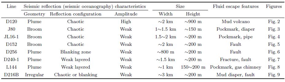
Many seismic reflections with plume, broom, and irregular shapes showing chaotic reflections and weak amplitudes, in sharp contrast with the reflections of the surrounding seawater column, are found in the Dongsha uplift and Zhongjiannan basin. Combined with the analysis of fluid flow in basins, the unusual seismic reflection characteristics are speculated to reflect the active cold seeps on the seabed. However, in some cases cold seeps with amplitude increase in seismic sections may contain more argillaceous and fine-grained particles caused by suspension.
Fluid flow structures such as diapirs, pipes, gas chimneys, faults, fractures, pockmarks, and mud volcanoes are developed widely in the studied area. Fluids such as gas and oil can ooze through these structures escaping onto the seabed. The characteristics and sizes of submarine cold seeps as well as the associated fluid flow structures are summarized in Table 1. Although the results of this study require further confirmation by field studies, they provide a new detection method for submarine cold seeps.
ACKNOWLEDGMENTSWe thank the Guangzhou Marine Geological Survey for the support. Especially, we are grateful to Zhenyu Feng, the director of the data processing institute, Dr. Baojin Zhang and other colleagues for their generous help and support. The authors would like to thank Enago (www.enago.cn) for the English language review and two anonymous reviewers for their helpful comments. Bathymetric data in this article were taken from the GEBCO digital atlas. This research is financially supported by the National Natural Science Foundation of China (41576047 and 41606077) and the State Key Program of the Major Research plan of the National Natural Science Foundation of China (91128205).
| [] | Bai Y, Song H B, Guan Y X, et al. 2014. Structural characteristics and genesis of pockmarks in the northwest of the South China Sea derived from reflective seismic and multibeam data. Chinese J. Geophys. (in Chinese) , 57 (7) : 2208-2222. DOI:10.6038/cjg20140716 |
| [] | Berndt C. 2005. Focused fluid flow in passive continental margins. Philos. Trans. R. Soc. London, Ser. A , 363 (1837) : 2855-2871. DOI:10.1098/rsta.2005.1666 |
| [] | Chen D F, Chen X P, Chen G Q. 2002. Geology and geochemistry of cold seepage and venting-related carbonates. Acta Sedimentologica Sinica (in Chinese) , 20 (1) : 34-40. |
| [] | Chen J X, Guan Y X, Song H B, et al. 2015. Distribution characteristics and geological implications of pockmarks and mud volcanoes in the northern and western continental margins of the South China Sea. Chinese J. Geophys. (in Chinese) , 58 (3) : 919-938. DOI:10.6038/cjg20150319 |
| [] | Chen J X, Song H B, Guan Y X, et al. 2015. Morphologies, classification and genesis of pockmarks, mud volcanoes and associated fluid escape features in the northern Zhongjiannan Basin, South China Sea. Deep Sea Res. Part Ⅱ , 122 : 106-117. DOI:10.1016/j.dsr2.2015.11.007 |
| [] | Chen J X, Bai Y, Guan Y X, et al. 2016. Geophysical analysis of abnormal seismic (oceanography) reflection characteristics of oceanic bottom boundary layer. Chinese J. Geophys. (in Chinese) , 59 (6) : 2148-2161. DOI:10.6038/cjg20160620 |
| [] | Chen L, Zhong G J. 2008. Seismic stratigraphic analysis of Zhongjiannan Basin in South China Sea. Geophysical Prospecting for Petroleum (in Chinese) , 47 (6) : 609-616. |
| [] | Chen Z, Yang H P, Huang Q Y, et al. 2007. Characteristics of cold seeps and structures of chemoauto-synthesis-based communities in seep sediments. Journal of Tropical Oceanography (in Chinese) , 26 (6) : 73-82. |
| [] | Chen Z, Yang H P, Huang Q Y, et al. 2008. Diagenetic environment and implication of seep carbonate precipitations from the southwestern Dongsha Area. South China Sea. Geoscience (in Chinese) , 22 (3) : 382-389. |
| [] | Fyhn M B W, Nielsen L H, Boldreel L O, et al. 2009. Geological evolution, regional perspectives and hydrocarbon potential of the northwest PhuKhanh Basin, offshore Central Vietnam. Marine and Petroleum Geology , 26 (1) : 1-24. DOI:10.1016/j.marpetgeo.2007.07.014 |
| [] | Gao H F, Chen L. 2006. An analysis of structural framework and formation mechanism of Zhongjiannan basin in the west of South China Sea. Oil and Gas Geology (in Chinese) , 27 (4) : 512-516. |
| [] | Gao H F, Wang Y T, Guo L H. 2007. Petroleum geological conditions and prospects in the Zhongjiannan basin in the western South China Sea. Geology in China (in Chinese) , 34 (4) : 592-598. |
| [] | Gong Y H, Wu S G, Zhang G X, et al. 2008. Relation between gas hydrate and geologic structures in Dongsha Islands Sea Area of South China Sea. Marine Geology and Quaternary Geology (in Chinese) , 28 (1) : 99-104. |
| [] | Greinert J, Artemov Y, Egorov V, et al. 2006. 1300-m-high rising bubbles from mud volcanoes at 2080 m in the Black Sea:Hydroacoustic characteristics and temporal variability. Earth Planet. Sci. Lett. , 244 (1-2) : 1-15. DOI:10.1016/j.epsl.2006.02.011 |
| [] | Gu Z F, Zhang Z X, Liu H S. 2006. Seismic features of shallow gas in the western area of the Yellow Sea. Marine Geology & Quaternary Geology (in Chinese) , 26 (3) : 65-74. |
| [] | Gu Z F, Liu H S, Zhang Z X. 2008. Acoustic detecting method for bubbles from shallow gas to sea water. Marine Geology & Quaternary Geology (in Chinese) , 28 (2) : 129-135. |
| [] | Holbrook W S, Páramo P, Pearse S, et al. 2003. Thermohaline fine structure in an oceanographic front from seismic reflection profiling. Science , 301 (5634) : 821-824. DOI:10.1126/science.1085116 |
| [] | Judd A G. 2003. The global importance and context of methane escape from the seabed. Geo-Mar. Lett. , 23 (3-4) : 147-154. DOI:10.1007/s00367-003-0136-z |
| [] | Judd A, Hovland M. 2007. Seabed Fluid Flow:The Impact on Geology, Biology and the Marine Environment[M]. Cambridge: Cambridge University Press . |
| [] | Kopf A J. 2002. Significance of mud volcanism. Rev. Geophys. , 40 (2) : 2-1. |
| [] | Kruglyakova R, Gubanov Y, Kruglyakov V, et al. 2002. Assessment of technogenic and natural hydrocarbon supply into the Black Sea and seabed sediments. Cont. Shelf Res. , 22 (16) : 2395-2407. DOI:10.1016/S0278-4343(02)00064-X |
| [] | Liu A, Wu S M, Cheng W H. 2011. Tectonic subsidence history and dynamic mechanism of the Dongsha rise in the Zhujiang River Mouth Basin. Acta Oceanologica Sinica (in Chinese) , 33 (6) : 117-124. |
| [] | Luan X W, Zhao K B, Obzhirov A, et al. 2008. Characteristics of shallow gas hydrate in Okhotsk Sea. Sci. China Ser. D:Earth Sci. , 51 (3) : 415-421. DOI:10.1007/s11430-008-0018-3 |
| [] | Luan X W, Liu H, Yue B J, et al. 2010. Characteristics of cold seepage on side scan sonar sonogram. Geoscience (in Chinese) , 24 (3) : 474-480. |
| [] | Rovere M, Gamberi F, Mercorella A, et al. 2014. Venting and seepage systems associated with mud volcanoes and mud diapirs in the southern Tyrrhenian Sea. Mar. Geol. , 347 : 153-171. DOI:10.1016/j.margeo.2013.11.013 |
| [] | Sassen R, Losh S L, Cathles Ⅲ L, et al. 2001. Massive vein-filling gas hydrate:relation to ongoing gas migration from the deep subsurface in the Gulf of Mexico. Mar. Petrol. Geol. , 18 (5) : 551-560. DOI:10.1016/S0264-8172(01)00014-9 |
| [] | Sauter E J, Muyakshin S I, Charlou J L, et al. 2006. Methane discharge from a deep-sea submarine mud volcano into the upper water column by gas hydrate-coated methane bubbles. Earth Planet. Sci. Lett. , 243 (3-4) : 354-365. DOI:10.1016/j.epsl.2006.01.041 |
| [] | Shang J J, Sha Z B, Liang J Q, et al. 2013. Seep gas acoustic features and its indication to gas hydrate exploration on the slope of the Northeastern South China Sea. Gresearch of Eological South China Sea (in Chinese) (1) : 25-36. |
| [] | Song H B, Bai Y, Pinheiro L, et al. 2012a. Analysis of ocean internal waves imaged by multichannel reflection seismics, using ensemble empirical mode decomposition. J. Geophys. Eng. , 9 : 302-311. DOI:10.1088/1742-2132/9/3/302 |
| [] | Song H B, Geng J H, Wang H K, et al. 2001. A preliminary study of gas hydrates in Dongsha region north of South China Sea. Chinese J. Geophys. (in Chinese) , 44 (5) : 687-695. |
| [] | Song H B, Pinheiro L M, Ruddick B, et al. 2012b. Seismic Oceanography: a new geophysical tool to investigate the thermohaline structure of the oceans. //Oceanography. InTech Open Access Publisher. |
| [] | Sun Q L, Wu S G, Cartwright J, et al. 2012. Shallow gas and focused fluid flow systems in the Pearl River Mouth Basin, northern South China Sea. Mar. Geol. , 315-318 : 1-14. DOI:10.1016/j.margeo.2012.05.003 |
| [] | Sun Q L, Wu S G, Cartwright J, et al. 2013. Focused fluid flow systems of the Zhongjiannan Basin and Guangle Uplift. South China Sea. Basin Res. , 25 (1) : 97-111. |
| [] | Wu B H, Zhang G X, Zhu Y H, et al. 2003. Progress of gas hydrate investigation in China offshore. Earth Sci. Front. (in Chinese) , 10 (1) : 177-189. |
| [] | Wu N Y, Liang J Q, Wang H B, et al. 2008. Marine gas hydrate system:state of the art. Geoscience (in Chinese) , 22 (3) : 356-362. |
| [] | Wu N Y, Yang S X, Wang H B, et al. 2009. Gas-bearing fluid influx sub-system for gas hydrate geological system in Shenhu Area, Northern South China Sea. Chinese J. Geophys. (in Chinese) , 52 (6) : 1641-1650. DOI:10.3969/j.issn.0001-5733.2009.06.027 |
| [] | Wu S G, Liu Z, Wang W Y, et al. 2004a. Late Cenozoic neotectonics in the Dongsha Islands region and its responds to collision between Chinese continental margin and Luzon. Oceanologiaet Limnologia Sinica (in Chinese) , 35 (6) : 481-490. |
| [] | Wu S G, Zhang G X, Guo C S, et al. 2004b. Geological constraint on the distribution of gas hydrate in the Dongsha continental slope of South China Sea. Acta Petrolei Sinica (in Chinese) , 25 (4) : 7-12. |
| [] | Wu S G, Gong Y H, Mi L J, et al. 2010. Study on hydrocarbon leakage system and associated gas hydrate reservoirs in the deepwater basin of Northern South China Sea. Geoscience (in Chinese) , 24 (3) : 433-440. |
| [] | Yan P, Wang Y L, Zheng H B, et al. 2014. Geophysical features of mud volcanoes in the waters southwest of the Dongsha Islands. Acta Oceanologica Sinica (in Chinese) , 36 (7) : 142-148. |