2 Lanzhou Institute of Seismology, China Earthquake Administration, Lanzhou 730000, China
The Yishu fault belt is the major part of Shandong-Jiangsu-Anhui segment of Tanlu fault zone, it belongs separately to three geotectonic units: Sino-Korea fault block, Qinling-Dabei fold belt and Yangtze fault block.
Five faults are distributed from east to west in Yishu fault belt. Three independent rupture units of fault are divided in the fault belt, include Anqiu, Juxian-Tancheng, Xinyi-Sihong rupture unit, which show obviously different tectonic characteristics and active level (Li et al., 1994).
There are several deep crust structure researches in the Shandong-Jiangsu-Anhui segment of the Tanlu fault zone and adjacent areas. Two wide angle reflection and refraction deep seismic sounding profiles stride the Tanlu fault zone in this area (Liu et al., 1983, Geoscience Transect Research Group of CSB, 1991, 1992). Researches on crust-mantle structure through the data recorded by the portable broadband seismic array across Tanlu fault zone in Shandong (Ling et al., 2006), magnetotelluric sounding researches (Ling et al., 2006; Xiao et al., 2008; Zhang, 2008), and geophysical researches on gravity, magnetic, and geothermal field (Wang et al., 1995; Hao et al., 2004; Li et al., 2009) are studied in the area. Seismic tomography using natural earthquake body waves is an effective method to research the internal structure of crust in a large range, the internal structure patterns of different precisions using this method can be acquired according to data and research purpose in crust, mantle, even the earth core. Li et al. (2006) acquired velocity structure of the crust and upper mantle around Bohai Sea area through seismic tomography using records of seismic stations around Bohai Sea from 1978 to 2003, with a grid spacing of 0.5°×0.6°, however, the research selected a large range (30°N-45°N, 110°E-130°E) on a coarse grid, didn’t set focus on Tanlu fault zone especially. Liu et al. (1995) obtained velocity structure of the crust and upper mantle of the Qinling-Dabie orogenic belts and both the northern and southern fringes (29°N-38.7°N, 102°E-119°E) using P-wave arrival time data of seismic stations from 1980 to 1990, with a grid spacing of 1°×1°. Xu et al. (2000) acquired the velocity structure of the crust and upper mantle beneath the Dabie-Sulu collision orogen (28°N-39°N, 112°E-124°E), using arrival time data of local and teleseismic events from 1981 to 1996. But all of the above researches didn’t focus on Tanlu fault zone. Based on relocation of earthquakes in Jiangsu and neighboring areas, Huang et al. (2011) acquired the crustal velocity structure beneath the Shandong-Jiangsu-Anhui segment of the Tanlu fault zone and adjacent areas using arrival time data, with a grid spacing of 40 km×40 km. Combining the research results of natural and artificial seismic events, some basic knowledge of crustal velocity structure is obtained, that is, the crust can be divided into three layers, i. e., upper, middle and lower crust, the depth of the Moho discontinuity gradually deepens from northeast to southwest, the deepest point is located at Dabie mountains. Where low velocity layers exist in the middle crust, where occur moderate and stronger earthquakes correspondingly. The P-wave velocity of Sulu fold belt is higher than that of adjacent areas. The main characteristics of velocity structure of the research area are discussed systematically in other papers (Huang et al., 2011; Li et al., 2014).
Yishu fault belt is the seismogenic fault of the M8½ earthquake of July 25, 1688 in Tancheng, it is a hot research region and is also a potential epicenter of future strong earthquakes. The geologists show different activity level at different segment (Li et al., 1994). We are concerned for the relationship among velocity structure, fault activity and earthquakes. We select and relocate local earthquakes occurred surrounding and in the research area from 1980 to 2011. Based on the travel-time data of Pg, Sg, Pm, Sm, Pn, and Sn waves of those earthquakes, using GABWIT (Genetic Algorithms in Body Wave Inversion of Traveltime) inversion method, the 3D velocity structure beneath the research area was imaged by seismic tomography, with the constraints from artificial seismic research results in the research area. The research focus in the paper includes the main characteristics of velocity structure of different fault segments and their relationship with geology factors such as exposed strata, rupture units of the fault zone, Sulu UHPM belt, detention of volcanics or different tectonic blocks, fault activity level, seismic activity and velocity difference at both sides along Yishu fault belt. The consistency of velocity segments and rupture units indicates that the Xinyi-Sihong segment is a locked segment of the Tanlu fault, where strong earthquakes may occur in the future.
2 METHODOLOGYWe adopt an inversion technique GABWIT (Genetic Algorithms in Body Wave Inversion of Traveltime) to study the 3D-crustal velocity structure (Zhang et al., 1998, 2003, 2003; Li et al., 2007). This method has Xiong Z et al.: Segmentation of Crustal Velocity Structure Beneath the Shandong-Jiangsu-Anhui Segment · · · 693 following features:
1) It combines multi-phases including Pg, Sg, Pm, Sm, Pn, Sn, pP, sS phases of earthquakes in the inversion;
2) It is constrained by artificial deep seismic sounding to provide effective prio-information;
3) The calculation of ray travel time uses a 3D ray tracing program by iterative method with stochastic distribution velocity model;
4) The optimization process uses a genetic algorithm of nonlinear global optimization; (Gao et al., 1996; Sambridge et al., 1992; Koch et al., 1993);
5) The resolution of inversion result was tested by checkerboard.
3 DATA AND MAIN RESULTS 3.1 DataThe research region is 31°N-37°N, 116°E-121°E, inversion region is 30°N-37°N, 113°E-122°E. We select the earthquakes occurred from 1980 to 2011 in the research area, recorded by more than 3 seismic stations. Totally 6278 events, with 123022 arrival time data (including Pg, Sg, Pm, Sm, Pn, Sn waves) are used in inversion.
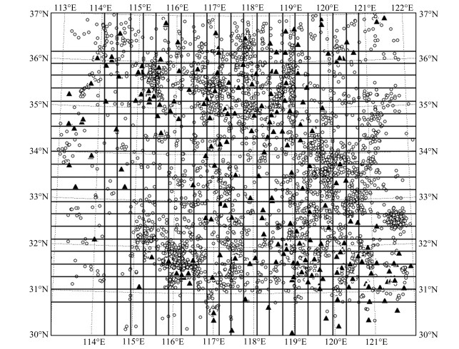
Grid node numbers are 22×22×7, with unequal spacing i.e., 130, 30, 30, …, 30, 137.1 km respectively in the latitudinal direction (X axis), 80, 30, 30, …, 30, 97.6 km respectively in the longitudinal direction (Y axis), and 2, 3, 5, 5, 5, 5, 20 km respectively in vertical direction (Z axis). The construction of primary P wave velocity model refers to the result of the geosciences transect of Shanghai Fengxian-Nei Mongol Alxa profile (HQ-13 deep seismic sounding section, Geoscience Transect Research Group of CSB, 1992). The selected seismic stations, events and calculation grid refer to Fig. 1.
|
Fig. 1 Distribution of seismic events, seismic stations and computational grid Circles denote seismic events, triangles denote seismic stations, dashed lines show coordinate system, and solid lines show computational grid. |
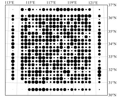
The resolutions of different layers in research region are relatively high, tested by checkerboard. Because of the limited space, we only give out the checkerboard at 10~15 km layer (Fig. 2).
|
Fig. 2 The Checkerboard at 10~15 km layer |
The basic result and knowledge of inversion has been published (Mei et al., 2015). We only analyze and discuss the characteristics of velocity structure of the different fault segment in Tanlu fault zone in this paper.
(1) 0~2 km layer
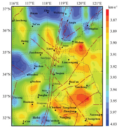
Figure 3 shows the velocity image of the layer at the depth of 0~2 km. This layer in Tanlu fault zone of the research region can be divided into three different velocity segments: ①North of 35.3°N (Junan) with Fig. 2 The Checkerboard at 10~15 km layer high velocity, about 3.95~4.03 km·s-1; ② 32.5°N-35.3°N with low velocity, about 3.89~3.93 km·s-1; ③ south of 32.5°N (Dingyuan) with high velocity, about 3.94~3.97 km·s-1. It can be further subdivided into five different velocity segments: ① North of 35.3°N (Junan) with relatively high velocity; ② 34.5°N-35.2°N (from Junan to Tancheng) with low velocity; ③ 33°N-34.5°N (from Xinyi to Wuhe), from Xinyi to Suqian with relatively high velocity, while from Suqian to Sihong with relatively low velocity; ④ 32.5°-33°N (from Wuhe to Dingyuan) with relatively low velocity; ⑤ South of 32.5°N (Dingyuan) with high velocity.
|
Fig. 3 Velocity image at depth 0~2 km |
The velocity of this layer shows difference on the two sides of the Tanlu fault belt, i.e north of 35.3°N, the velocity on west side is lower than that on the east side, 34.5°N-35.3°N with little velocity difference between the two sides, 32.5°N-34°N, the velocity on west side is higher than that on the east side.
(2) 2~5 km layer
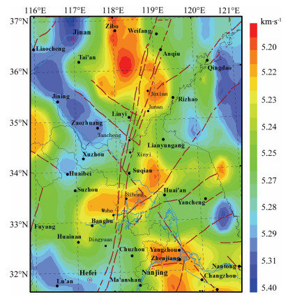
Figure 4 shows the velocity image of the layer at the depth of 2~5 km. This layer is composed of Palaeozoic basement, south of 32.7°N with high velocity, about 5.28~5.29 km·s-1, 32.7°N-35.1°N with moderate velocity, about 5.23~5.26 km·s-1, north of 35.1°N with relatively low velocity, about 5.20~5.22 km·s-1. Therefore the velocity of this layer shows segmentation characters, i e, it is high in the south segment, moderate in middle segment, and relatively low in the north segment. The segmentation characters also exist in the Tanlu fault belt.
|
Fig. 4 Velocity image at depth 2~5 km |
The velocities of this layer show difference between the two sides of the Tanlu fault belt, i e, north of 35.2°N with little velocity difference between the two sides, 33°N-35.2°N, the velocity on west side is higher than that on the east side, south of 33°N with little velocity difference between the two sides.
(3) 5~10 km layer
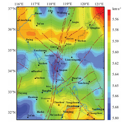
Figure 5 shows the velocity image of the layer at depth 5~10 km. This layer is also in the upper crust, south of 33°N with moderate velocity, about 5.59~5.62 km·s-1, 33°N-35.2 °N, with high velocity, about 5.65~5.68 km·s-1, which shows that high velocity Sulu UHPM belt exists in this layer, north of 35.2°N with relatively low velocity, about 5.58~5.59 km·s-1. The velocity of this layer also shows segmentation characters, and the segmentation characters also exist in the Tanlu fault belt.
|
Fig. 5 Velocity image at depth 5~10 km |
(4) 10~15 km layer
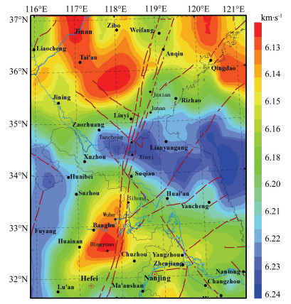
Figure 6 shows the velocity image of the layer at depth 10-15km. This layer is in the lower part of the upper crust and the upper part of the middle crust. South of 32.5°N the velocity is high, about 6.18~6.30 km·s-1. The velocity is low in the area between 32.5°N to 33.7°N, about 6.13~6.16 km·s-1. While in the area between 33.7°N and 35.1°N, the velocity is very high, up to 6.22~6.30 km·s-1, where exists high velocity Sulu UHPM belt. North of 35.1°N the velocity is relatively low, about 6.15~6.16 km·s-1. The velocity of this layer also shows segmentation characters.
|
Fig. 6 Velocity image at depth 10~15 km |
The velocity of this layer shows difference on the two sides of the Tanlu fault belt. The velocity of the layer on west side of the fault belt is generally lower than that on the east side, also shows segmentation characters from south to north in the fault belt.
(5) 15~20 km layer
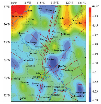
Figure 7 shows the velocity image of the layer at the depth of 15~20 km. This layer is in the middle crust. The velocity in north segment and south segment is generally higher than the middle segment. North of 35.1°N the velocity is relatively high, about 6.51~6.52 km·s-1, and the velocity in the area south of 32.8°N is also high, about 6.51~6.52 km·s-1. While the velocity in the area from 32.8 N° to 35.1°N is relatively low, about 6.48~6.49 km·s-1. The velocity of this layer still shows segmentation characters.
|
Fig. 7 Velocity image at depth 15~20 km |
The velocity of this layer on the west side of the fault belt is generally lower than that on the east side, also shows segmentation characters from south to north in the fault belt.
(6) 20~25 km layer
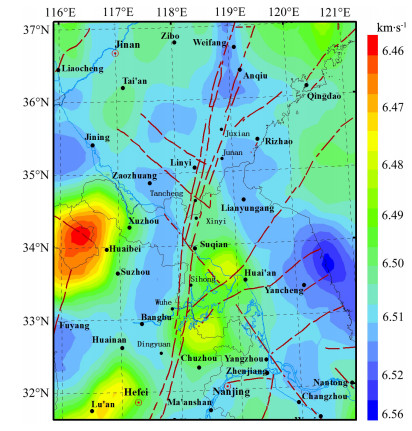
Figure 8 shows the velocity image of the layer at depth 20~25 km. This layer is in the lower part of the middle crust and the upper part of the lower crust. The velocity in north segment and south segment is also generally higher than the middle segment. North of 35°N the velocity is high, about 6.51~6.52 km·s-1, and the velocity in the area south of 32.5°N is also high, changes between 6.50~6.51 km·s-1. While the velocity in the area from 32.5 N° to 35.1°N is relatively low, about 6.48~6.50 km·s-1. The velocity of this layer still shows segmentation characters. In fact, we can find that in 20~25 km layer there is a low velocity layer (Mei et al., 2015). The velocity of this layer on the west side of the fault belt is generally higher than that on the east side, also show segmentation characters in the fault belt, which indicates the difference of tectonic blocks’ composition.
|
Fig. 8 Velocity image at depth 20~25 km |
(7) 25 km~M layer
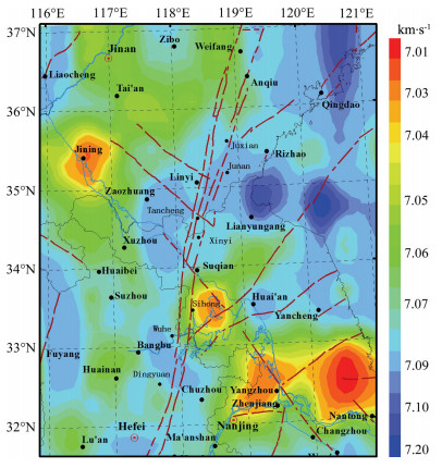
Figure 9 shows the velocity image of the layer at the depth of 25 km-Moho. This layer is located in the lower crust. The velocity in the area from 33°N to 34.7°N is relative low, about 7.05~7.06 km·s-1, which in other segments is high, changes between 7.09 to 7.10 km·s-1. The velocity of this layer still shows segment ation characters, which indicates the difference of tectonic blocks’ composition, shows different seismic activity, and related to the position of NW faults intersecting with the Tanlu fault belt.
|
Fig. 9 Velocity image at depth 25 km to Moho |
The velocity of this layer shows difference on the two sides of the Tanlu fault belt. The velocity on the west side of the fault belt is lower than that on the east side in the area north of 35.2°N, which is opposite to the area from 33°N to 35.2°N.
The velocity image varies with depth, refer to Table 1.
|
|
Table 1 Velocity segment characters at different depth |
Through above analysis, the crustal velocity structure beneath the Shandong-Jiangsu-Anhui segment of the Tanlu fault zone and adjacent areas can be roughly divided into three different segments from top to bottom, which include the south segment (south of 32.5°N-33°N), middle segment (between 32.5°N-33°N to 35°N-35.3°N) and north segment (north of 35°N-35.3°N).
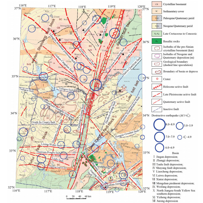
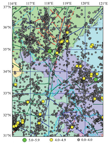
4 PRELIMINARY THOUGHTS ON CRUSTAL VELOCITY SEGMENTATION IN THE SHANDONG-JIANGSU-ANHUI SEGMENT OF THE TANLU FAULT ZONE 4.1 The Geological Structure Segmentation and Seismic LevelsFigure 10 shows seismotectonics for the Shandong-Jiangsu-Anhui segment of the Tanlu fault zone and adjacent areas. Earthquake epicentres of historical earthquakes with magnitude above M4¾ or M4.7 (after 1970) in the research region are shown in the map. In addition, Fig. 11 shows the epicentres of earthquakes occurred from 1980 to 2011 for inversion, which are relocated in the paper.
|
Fig. 10 Seismotectonics of the Shandong-Jiangsu-Anhui segment of the Tanlu fault zone and adjacent areas |
|
Fig. 11 Distribution of epicenters for the ShandongJiangsu-Anhui segment of the Tanlu fault zone and adjacent areas (Jan. 1980 to Dec. 2011) |
The research region in the paper is located in the Yishu fault belt of Tanlu fault zone. Three independent rupture units of fault are divided in the 1:50000 geological map of the area from Weifang to Jiashan in the fault belt. Namely, Anqiu, Juxian-Tancheng, Xinyi-Sihong rupture units, which show obviously different tectonic characteristics such as geometric structure, motion character, maximum displacement, active time, recurrence interval of large earthquakes, present movement, and deep tectonic background (Li et al., 1994). According to the research of the motion of the Holocene fault in Weifang-Jiashan segment of the Tanlu fault belt (Cao et al., 1997), the three segments on the north of Sihong were active in Late Quaternary, while the segment on the south of Sihong county were active in Early Quaternary. Fig. 3 shows that the 0~2 km layer in the Tanlu fault belt can be divided into five different velocity segments:
(1) North of 35.3°N (Junan) with relatively high velocity corresponds to Anqiu segment, where occurred Anqiu M7 earthquake in 70 B.C. (Fig. 10), and lots of moderate and small earthquakes after 1970 (Fig. 11). The Mesozoic or older strata outcrop to the surface in the segment and both sides of the fault (Fig. 10), which have higher velocity than the new sedimentary strata in other site, similar to the inversion result.
(2) 34.5°N-35.3°N (from Junan to Tancheng) has low velocity, the lowest velocity is located in Haizhou bay on the east side of the fault belt, about 3.87 km·s-1. The M8 earthquake of July 25, 1688 in Tancheng, and lots of moderate and small earthquakes after 1970 occurred in the segment. There exist Cretaceous strata or deposit strata since Neogene, which have low velocity. Paleozoic strata with low velocity outcrop to the surface on the west side of Tanlu fault belt, crystalline basement with high velocity exists in the more westward area, the velocity image of this layer corresponds basically to the geological background.
(3) 33°N-34.5°N, this site and Xinyi-Sihong segment are basically identical. The velocity is relatively high in the area from Xinyi to Suqian, about 3.93~3.94 km·s-1, where exist Cretaceous strata, no destructive earthquake but some small earthquakes after 1970 occurred. The velocity is relatively low in the area from Suqian to Sihong, where no destructive earthquake and few small earthquakes after 1970 occurred. The velocity on west side of the fault belt is relatively higher than that on the east side. Paleozoic strata with relatively higher velocity exist on the west side of Tanlu fault belt.
(4) 32.5°N-33°N is the Sihong-Dingyuan segment, where a few M4~5 earthquakes occurred. The velocity of the area is relatively low, about 3.89 km·s-1. Northern Jiangsu plain is located on the east of the Tanlu fault belt in the segment, where exist very thick sedimentary strata (low velocity), the thickness of deposition since Neogene is above 1000 m, while the depth of pre-Sinian crystalline basement (high velocity) is above 7~10 km. Therefore the velocity of this layer in Northern Jiangsu plain is relatively low, the velocity image of this layer also corresponds basically to the geological background.
(5) South of 32.5°N the velocity is high. Some M4~5 earthquakes and small earthquakes after 1970 occurred in the segment, where Lower Jurassic to Cretaceous or Paleozoic strata formed, with relatively high velocity. Therefore the velocity of this layer is relatively high.
The crustal velocity structure beneath the research region can be divided into three different segments: ① north segment (north of 35°N-35.3°N), where seismic activity level is high, Anqiu M7 earthquake in 70 B.C. and lots of moderate and small earthquakes after 1970 occurred; ② middle segment (between 32.5°N-35°N), few destructive earthquake but the M8 earthquake of July 25, 1688 in Tancheng occurred; ③ south segment (south of 32.5°), where lots of moderate and small earthquakes occurred, and the highest magnitude was M5~6 (Figs. 10, 11).
It is not accidental that the crustal velocity structure segmentation beneath the research region is basically similar to independent rupture unit of fault given by geologists. The consistency indicates that Xinyi-Sihong segment of the Tanlu fault belt may be a locked segment, where strong earthquakes may occur in the future.
4.2 Relation of Crustal Velocity Structure and Tectonic BlocksThe research region belongs respectively to geotectonic units such as western Shandong fault block, Xuhuai fault block (west of the Tanlu fault belt), Shandong-Liaoning fault block (east of Tanlu fault belt, north of Wulian-Rongcheng fault) in the North China fault block region, Lusu fold belt in the Qinling-Dabei fold belt region, and Lower Yangtze fault block (east of the Tanlu fault belt, south of Huaiyin-Xiangshuikou fault) in the Yangtze fault block region (Fig. 10). The Tanlu fault belt intersects with tectonic boundaries Xiangsui-Jiashan fault at about 32.5°N, and Wulian-Rongcheng fault at about 35.1°N.
Although the velocity image changes with depth, the crustal velocity structure beneath the ShandongJiangsu-Anhui segment of the Tanlu fault zone can be roughly divided into three different segments from top to bottom. They include the south segment (south of 32.5°N-33°N), middle segment (between 32.5°N-33°N and 35°N-35.3°N), and north segment (north of 35°N-35.3°N). The segmentation of upper crust is related to insertion from Sulu UHPM belt, the segmentation of middle and lower crust is related to detention of volcanics. The velocities at west of Tanlu fault zone is higher than at east. The differences of velocity image at different depth show the different tectonic blocks, which have different evolution history and composition, which also means that this fault extends to Moho. The Tanlu fault zone in the north of 35°N is located in the North China fault block region, the section from 32.5°N to 35°N is the division line of Lusu fold belt and the North China fault block region, the section south of 32.5°N is the division line of lower Yangtze fault block region and North China fault block region, therefore the velocity structure segmentation indicates the different geological background such as geotectonic units, the phenomenon also exists in deep crust. Conversely, velocity structure segmentation proves that the research region belongs to different geotectonic units. Fig. 5 and Fig. 6 show that Sulu UHPM belt exists in upper crust. The high resistivity area of Lusu fold belt (Xiao et al., 2008) is quite similar to the result in this paper. Previous studies indicate that the thickness is generally less than 10 km (Yang et al., 1999a, 1999b), but we get the depth of high velocity as 5~15 km. Sulu UHPM belt is formed in middle crust, with high velocity, but uplifted to upper crust at present in tectonic movement. The differences of velocity image at different depth show the different tectonic blocks, which have different evolution history and composition. The three different segments of crust from top to bottom are the result of geological evolution in the long history.
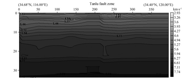
4.3 The Differences of Velocity Images on the Two Sides of Tanlu Fault BeltYang et al.(1999a, 1999b) holds that there is obvious difference of velocity on the east and west side of the Tanlu fault belt. Their understanding is similar to our research result, but there are different velotities for various segements and layers. The velocity image of the vertical profile across of the Tanlu fault zone near Suqian (Fig. 12) indicates that the velocity in upper and middle crust in the Tanlu fault belt is low, the velocity on the west side of the fault belt is higher than that on the east side. But there is little difference for the velocity in lower crust. Our previous studies indicate that the hypocenter depths are mainly distributed from 9 km to 20 km, about 68%, and about 17% from 21 to 30 km, few exceed 30 km (Huang et al., 2008). Earthquakes with deep hypocenter occurred in or close to the Tanlu fault belt indicates that it is a deep fault extending to Mehorovicic discontinuity, or even deeper, as the boundary of geotectonic units. The velocity structure segmentation in the Tanlu fault belt changes with depth, indicating that the fault belt is not a simple geometric surface from top to bottom, but interdigitating and discontineous in the deep part, while keeps its extending direction as the shallow layer.
|
Fig. 12 Velocity profile across of the Tanlu fault zone |
Different velocity segments at different depth beneath the Shandong-Jiangsu-Anhui segment of the Tanlu fault belt are related to geology factors. The velocity image at depth 0~2 km is related to the strata outcrop to the surface (see Table 1). The velocity in the middle segment is higher than that in the north segment and south segment in upper crust (at depth 2~15 km), it indicates that the basement of the down faulted basin in the middle segment is composed of high velocity matter. The inserting of Sulu UHPM belt made the velocity image more complex. In the middle and lower crust in the depth below 15 km, the velocity in middle segment of the Tanlu fault belt (33°N-35°N) is lower than that in the north and south segment of the belt at that depths. A narrow and long NNE extending Mesozoic down faulted basin formed in middle segment of the Tanlu fault belt (Fig. 10), where volcanic rock of Cretaceous Qingshan formation (K1q) and basalt or tuffaceous breccia of Neogene Fangshan formation (N1f) formed by volcanic activity. In the process of volcanic activity, low density matter formed in magmatic differentiation detain in middle and lower crust, the rocks become broken in multiphase tectonics and hydrothermal fluid concentrates in the fracture, those factors cause low velocity. Therefore, The velocity below 15km in middle segment (33°N-35°N) of the Tanlu fault belt is lower than that in the north or south segment of the belt. Because of the complexity of the velocity image, strong earthquakes are possibly gestated at the top or bottom of the local low velocity layer in the middle segment of Tanlu fault belt.
5 SUMMARY AND DISCUSSIONThe 3-D velocity structure beneath the Shandong-Jiangsu-Anhui segment of the Tanlu fault zone and adjacent areas is imaged by seismic tomography using GABWIT (Genetic Algorithms in Body Wave Inversion of Traveltime) method. Through analysis of the velocity images of different depths for the research area, we found that the crustal velocity structure is segmentated. For shallow layers, different velocity segments: north of 35.3°N, 34.5°N-35.3°N, and 33°N-34.5°N are related to exposed stratum, respectively corresponding to three rupture units of the Tanlu fault zone, that is Anqiu segment, Juxian-Tancheng segment, and Xinyi-Sihong segment, which have different earthquake activity patterns. It indicates that Xinyi-Sihong segment is a locked segment of the Tanlu fault. The crustal velocity structure beneath the Shandong-Jiangsu-Anhui segment of the Tanlu fault zone and adjacent areas can be roughly divided into three different segments from top to bottom. They include the south segment (south of 32.5°N-33°N), middle segment (between 32.5°N-33°N and 35°N-35.3°N), and north segment (north of 35°N-35.3°N). The segmentation of upper crust is related to insertion from Sulu UHPM belt, the segmentation of middle and lower crust is related to detention of volcanics. The velocities in the west of Tanlu fault zone is higher than that in the east. The differences of velocity image at different depths show the different tectonic blocks, which have different evolution history and composition, which also means that this fault extends to Moho. Conversely, velocity structure segmentation proves that the research region belongs to different geotectonic units. More attention should be payed to Xinyi-Sihong segment of the Tanlu fault belt, where strong earthquakes may occur in the future.
ACKNOWLEDGMENTSThis research is supported by the National Natural Science Foundation of China (40974031), Science and Technology Development Project of Jiangsu Province (BE2009691), Active Fault Survey Project of Suqian, and Old Expert Foundation of China Earthquake Administration (2016005).
| [] | Chao H T, Li J L, Cui Z W, et al. 1997. Mode of motion of the Holocene fault in Weifang-Jiashan segment of the Tanlu Fault Zone and earthquake-generating model. Journal of Seismological Research (in Chinese) , 20 (2) : 218-226. |
| [] | Gao E G, Xu G M. 1996. A new kind of step by step iterative ray-tracing method. Acta Geophysica Sinica (in Chinese) , 39 (supplement) : 302-308. |
| [] | Geoscience Transect Research Group of CSB. 1991. Explanatory Notes of the Geosciences Transect of Jiangsu Xiangshui-Nei mengol Mandula (in Chinese)[M]. Beijing: Seismological Press . |
| [] | Geoscience Transect Research Group of CSB. 1992. Explanatory Notes of the Geosciences Transect of Shanghai Fengxian-Nei mongol Alxa (in Chinese)[M]. Beijing: Seismological Press . |
| [] | Hao T Y, Suh M, Liu J H, et al. 2004. Deep structure and boundary belt position between SinoKorean and Yangtze blocks in Yellow Sea. Earth Science Frontiers (in Chinese) , 11 (3) : 51-61. |
| [] | Huang Y, Li Q H, Zhang Y S, et al. 2008. Relocation of earthquakes in Jiangsu and neighboring areas, China and analysis of structural features. Chinese J. Geophys. (in Chinese) , 51 (1) : 175-185. |
| [] | Huang Y, Li Q H, Zhang Y S, et al. 2011. Crustal velocity structure beneath the Shandong-Jiangsu-Anhui segment of the Tancheng-Lujiang Fault Zone and adjacent areas. Chinese J. Geophys. (in Chinese) , 54 (10) : 2549-2559. DOI:10.3969/j.issn.0001-5733.2011.10.012 |
| [] | Koch M. 1993. Simultaneous inversion for 3-D crustal structure and hypocentres including direct, refracted and reflected phases-Ⅰ. Development, validation and optimal regularization of the method. Geophys. J. Int. , 112 (3) : 385-412. DOI:10.1111/gji.1993.112.issue-3 |
| [] | Li C F, Chen B, Zhou Z Y. 2009. Deep crustal structures of eastern China and adjacent seas revealed by magnetic data. Science in China Series D:Earth Sciences , 52 (7) : 984-993. DOI:10.1007/s11430-009-0096-x |
| [] | Li J L, Chao H T, Cui Z W, et al. 1994. Segmentation of active fault along the Tancheng-Lujiang Fault Zone and evaluation of strong earthquake risk. Seismology and Geology (in Chinese) , 16 (2) : 121-126. |
| [] | Li Q H, Zhang Y S, Bao H Y, et al. 2014. Crust velocity structure inference of the epicenter of the M8 1/2 earthquake at Tancheng, Shandong, China, in 1668. Earthquake Research in China (in Chinese) , 28 (3) : 320-334. |
| [] | Li Q H, Zhang Y S, Kim S G. 2007. 3-D crustal velocity tomography in the southern Korean Peninsula. Chinese J. Geophys. (in Chinese) , 50 (4) : 1073-1081. |
| [] | Li Z W, Xu Y, Hao T Y, et al. 2006. Seismic tomography and velocity structure in the crust and upper mantle around Bohai Sea area. Chinese J. Geophys. (in Chinese) , 49 (3) : 797-804. |
| [] | Ling C, Tian Y Z, Wei W X. 2006. A thinned lithospheric image of the Tanlu Fault Zone, eastern China:Constructed from wave equation based receiver function migration. J. Geophys. Res. , 111 (B9) . DOI:10.1029/2005JB003974 |
| [] | Ling C, Tian Y Z, Wei W X. 2006. Lianyungang-Linyi-Sishui deep seismic sounding profile and deep tectonic background of Linyi M8.5 earthquake. Earthquake (in Chinese) (3) : 11-17. |
| [] | Liu J H, Liu F T, Sun R M, et al. 1995. Seismic tomography beneath the Qinling-Dabie oroganic belts and both the northern and southern fringes. Acta Geophysica Sinica (in Chinese) , 38 (1) : 46-54. |
| [] | Sambridge M, Drijkoningen G. 1992. Genetic algorithms in seismic waveform inversion. Geophys. J. Int. , 109 (2) : 323-342. DOI:10.1111/gji.1992.109.issue-2 |
| [] | Wang L S, Li C, Shi Y S, et al. 1995. Distributions of geotemperature and terrestrial heat flow density in lower Yangtze area. Acta Geophysica Sinica (in Chinese) , 38 (4) : 469-476. |
| [] | Xiao X B, Zhao G Z, Wang J J, et al. 2008. Research on the deep electric structure of Sulu orogenic belt and adjacent area. Science in China (Series D) (in Chinese) , 38 (10) : 1258-1267. |
| [] | Xu P F, Liu F T, Wang Q C, et al. 2000. Seismic tomography beneath the Dabie-Sulu collision orogen-3-D velocity structures of lithosphere. Chinese J. Geophys. (in Chinese) , 43 (3) : 377-385. |
| [] | Yang W C, Cheng Z Y, Chen G J, et al. 1999a. Geophysical investigations in northern Sulu UHPM belt, Part I:deep seismic reflection. Chinese J. Geophys. (in Chinese) , 42 (1) : 41-52. |
| [] | Yang W C, Hu Z Y, Cheng G Y, et al. 1999b. Long profile of geophysical investigation from Tanchen to Lianshui, east-central China. Chinese J. Geophys. (in Chinese) , 42 (2) : 206-217. |
| [] | Zhang J H, Zhao G Z, Xiao X B, et al. 2010. Analysis of electric structure of the central Tanlu fault zone (Yishu fault zone, 36°N) and seismogenic condition. Chinese J. Geophys. (in Chinese) , 53 (3) : 605-611. DOI:10.3969/j.issn.0001-5733.2010.03.014 |
| [] | Zhang Y S, Li Q H, Liu Y W, et al. 2003. The seismic tomography software. Northwestern Seismological Journal (in Chinese) , 25 (2) : 170-174. |
| [] | Zhang Y S, Li Q H, Xu G M. 1998. Combined inversion technique to study 3-D crustal velocity structure by using seismic wave travel time and wave form (I)-theory and method. Northwestern Seismological Journal (in Chinese) , 20 (2) : 8-15. |
| [] | Zhang Y S, Zhou M D, Rong D L, et al. 2004. 3-D Velocity structure in the central-eastern part of Qilian Shan. Acta Seismologica Sinica (in Chinese) , 26 (3) : 247-255. |
 2016, Vol. 59


