2. Key Laboratory of Geo-detection (China University of Geosciences, Beijing), Ministry of Education, Beijing 100083, China;
3. School of Geophysics and Information Technology, China University of Geosciences, Beijing 100083, China
The Sichuan basin is the main part of the Middle-upper Yangtze craton. The aeromagnetic characteristic is the northeast-trending wide positive magnetic anomalies along with weak negative magnetic anomalies(Bao et al., 1985). It has experienced a long tectonic evolution since Archean, and was regarded as a stable coherent block until the collision with the Cathaysia block in late Neoproterozoic. The basement consists of Archean- Neoproterozoic crystalline rocks, which were overlain by the late Neoproterozoic to Phanerozoic sedimentary covers. Only some ca. 2.9–2.95 Ga old basement rocks outcropped in the western and southwestern margins, and the Three Gorges areas(Greentree et al., 2008; Qiu et al., 2000; Wu et al., 2012). The knowledge of the nature and distribution of the basement was limited because of the widespread sedimentary cover. The subsurface blind fault zones control the sedimentary covers and the subsequent tectonic evolution. Bouguer gravity anomaly is one of the main methods to study the crustal density structure. The Bouguer gravity anomalies after correction contain the gravity effects not only from all kinds of orebodies and structures in the crust, whose densities differ from the normal density distribution, but also from the undulating bottom surface of the crust resulting in huge deficits or surpluses of mass related to the upper mantle. They have good lateral resolution for structure studies. The residual Bouguer gravity anomaly after striping both the Moho surface and the sediment cover, could reflect the middle-lower crustal structure feature. The deep seismic reflection profile with the resolution of tens of meters is the key technique to reveal the detailed lithosphere structure. In this paper, we used the gravity data combined with other geophysical and geochemical data including the aeromagnetic anomalies, deep seismic reflection data to discuss the difference of the structure of the mid-lower crust between the western and eastern blocks of Sichuan Basin. The difference could present two continental nucleuses beneath the Yangtze block in Archean-Paleoproterozoic.
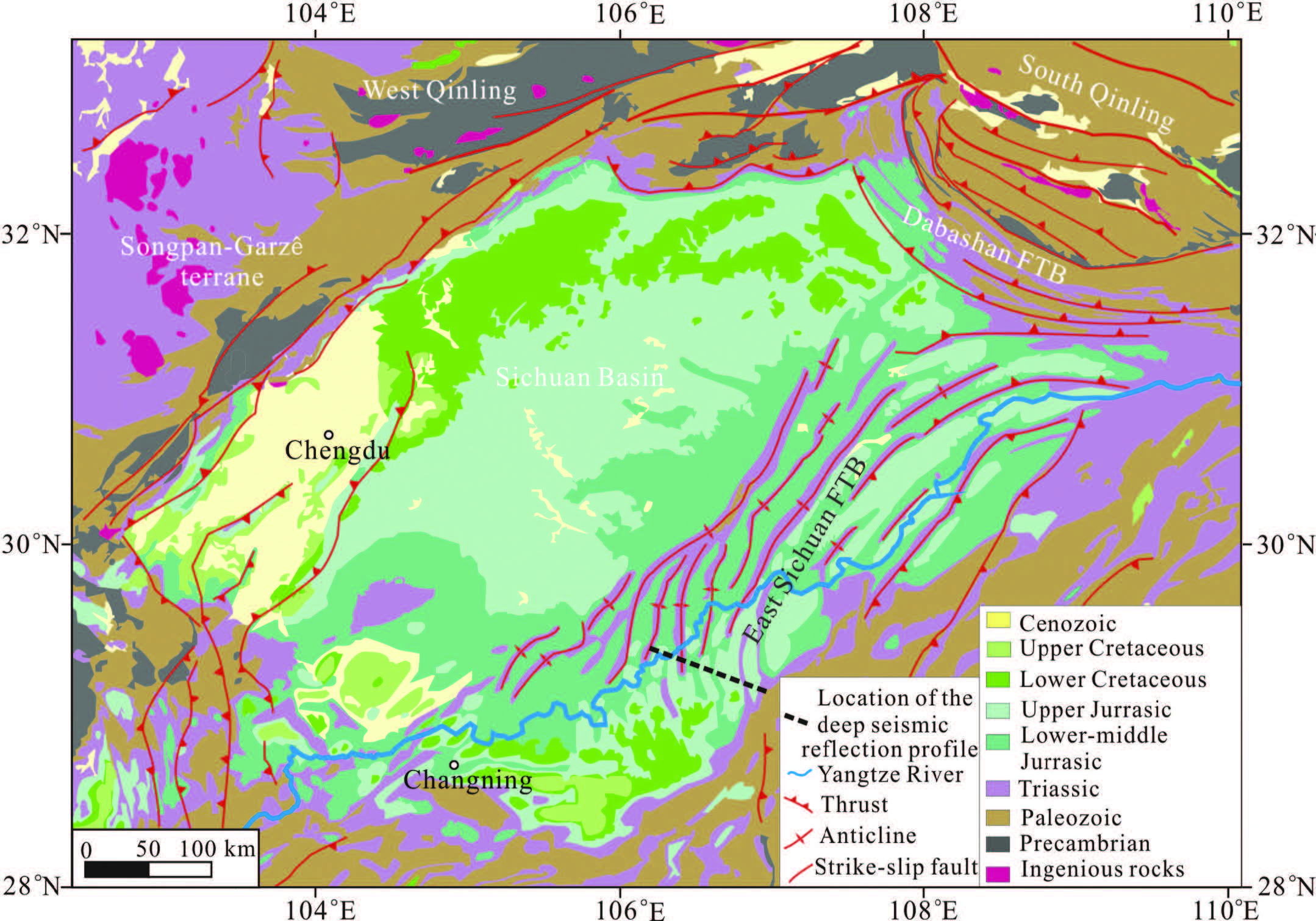
2 GEOLOGICAL SETTINGThe Sichuan Basin is the main part of the Middle-upper Yangtze craton. As one of the largest and most complex Archean cratons in China, the Yangtze craton consists of Archean-Paleoproterozoic crystalline basement(mostly hidden)surrounded by late Mesoproterozoic to early Neoproterozoic fold belts, which are locally unconformably overlain by middle Neoproterozoic weakly metamorphosed strata and late Neoproterozoic unmetamorphosed Sinian cover(Zhao and Cawood 2012). The exposed basement consists dominantly of Proterozoic rocks, only sparse outcrops of Archean rocks along the western and northern margins of the Yangtze Block(Fig. 1). With the development of isotopic analytical technology, nevertheless, more and more Archean crustal materials have been identified(Jiao et al., 2009; Qiu et al., 2000; Zheng et al., 2006). The discoveries suggest that the older basement may be widespread beneath most parts of the Yangtze craton(Wang et al., 2013a; Zhang et al., 2006a; Zheng et al., 2006). The Lengjiaxi and equivalent group, used to be considered Mesoproterozoic, are Neoproterozoic according to SHRIMP dating with a limit at 0.82 Ga, and is overlain by the Banxi group(0.82–0.75 Ga). Lengjiaxi group includes strongly deformed metas and stones, siltstones and slates with metamorphosed mafic-ultramafic volcanic intercalations, which is volcanic-sedimentary foundation. The Lengjiaxi group is equivalent to the Sibao group in northern Guangxi, Shuangqiaoshan group in Jiangxi, Xikou group in southern Anhui and Fanjingshan group in northeastern Guizhou. The Lengjiaxi group and its equivalent are angular uncomformably overlain by the Banxi group and the equivalent. Such an unconformity is considered to be the result of the Jinning movement in the Chinese literature in response to the final assemblage of the Yangtze with Cathaysia blocks(Guo et al., 1980, Zhou and Zhu, 1993 and Charvet et al., 199). Banxi group is a suite of flysch sediments, and consists mainly of shallow metamorphic(low greenschist-facies)purple and gray-green s and stones. The folded basement of the Yangtze craton finalized after the Jinning movement, on top of which are over 10 km thick sedimentary rocks covering most of the Yangtze block from Neoproterozoic to Cenozoic, including Nanhua system(0.75–0.635 Ga), Sinian(Ediacaran)system(0.635–0.542) and the Phanerozoic strata. The east Sichuan fold belt was a typical thin-skinned thrust belt, with two types of compressive deformation structure: the Chevron anticline(box syncline)type to the northwest and the chevron syncline(box anticline)type to the southeast separated by the Qiyue fault on the surface. The core of the comb-like folds is Triassic layers, and the limbs of the folds are Jurassic layers outcropped.
|
Fig.1 Geological map of the Sichuan Basin and adjacent regions (modified from 1:1000000 geological map of China, http://ogc.cgs.gov.cn) |
Bouguer gravity anomaly is the main data to study the crustal density structure and tectonics. They contain the gravity effects not only from all kinds of orebodies and structures in the crust, whose densities differ from the normal density distribution, but also from the undulating bottom surface of the crust resulting in huge deficits or surpluses of mass related to the upper mantle. They have a good lateral resolution for tectonic studies. In this paper, we assembled the previous deep seismic sounding profiles around the Sichuan Basin. And then after resampling and interpolation we obtained the fluctuating depth contours of the Moho interface and the bottom interface of sediment cover. We then calculated forwardly the anomalies caused by sedimentary cover and the Moho surface and then stripped them from the Bouguer gravity anomalies, to obtain the gravity anomalies reflecting the crustal structure and tectonic features between the sedimentary cover and the Moho surface.
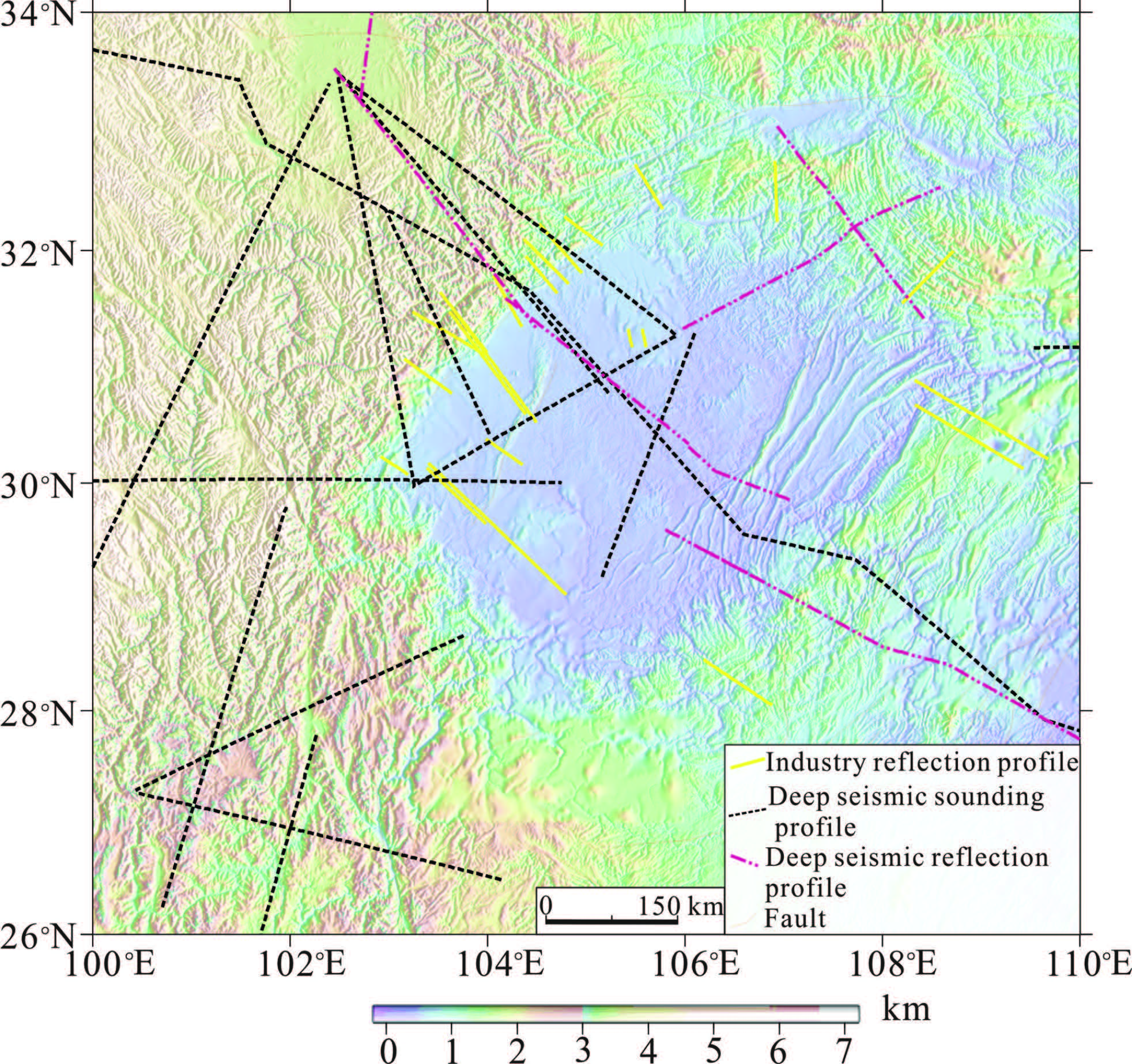
3.1 The Seismic Probing Work in the Sichuan Basin and Adjacent Fold BeltsFrom the 1970s, many deep seismic probing works, including deep seismic reflection profiling, wideangle reflection & refraction profiling and oil reflection profiling, were performed in the Sichuan Basin and adjacent regions. These data provided the scientific foundation for discussing the formation and evolution of the research region(Fig. 3; Xiong et al., 2009). DSS is the main method in the research region. From 1988, China Seismological Bureau(CSB)implemented the “Tangke-Pujiang-Langzhou”, “Fengjie-Guanyindang”, “Batang-Zizhong” and “Banzilan-Tangke” profiles in Longmen Shan thrust-fold belt and Three Gorges areas to study the crustal structure of this region(Chen et al., 1988; Wang et al., 2003). The Institute of Geophysics, Chinese Academy of Sciences finished “Lijiang-Xinshizhen”, “Changheba-Lazha”, “Lijiang- Zhehai” and “Xichang-Dukou” profiles(Lu et al., 1988; Xiong et al., 1993; Yin and Xiong, 1992). The Chinese Academy of Geological Sciences finished the near west-east trending “Aba-Shuangliu” and “Heishui-Shaoyang” profiles and north-south trending “Nanbu-Fushun” profile(Cao and Wang, 1997; Wang et al., 2005; Teng et al., 2013), which crossed the Longmen Shan thrust-fold belt, Sichuan Basin and Xuefeng fold belt during implementing the project of GGT(global geosciences transect).
|
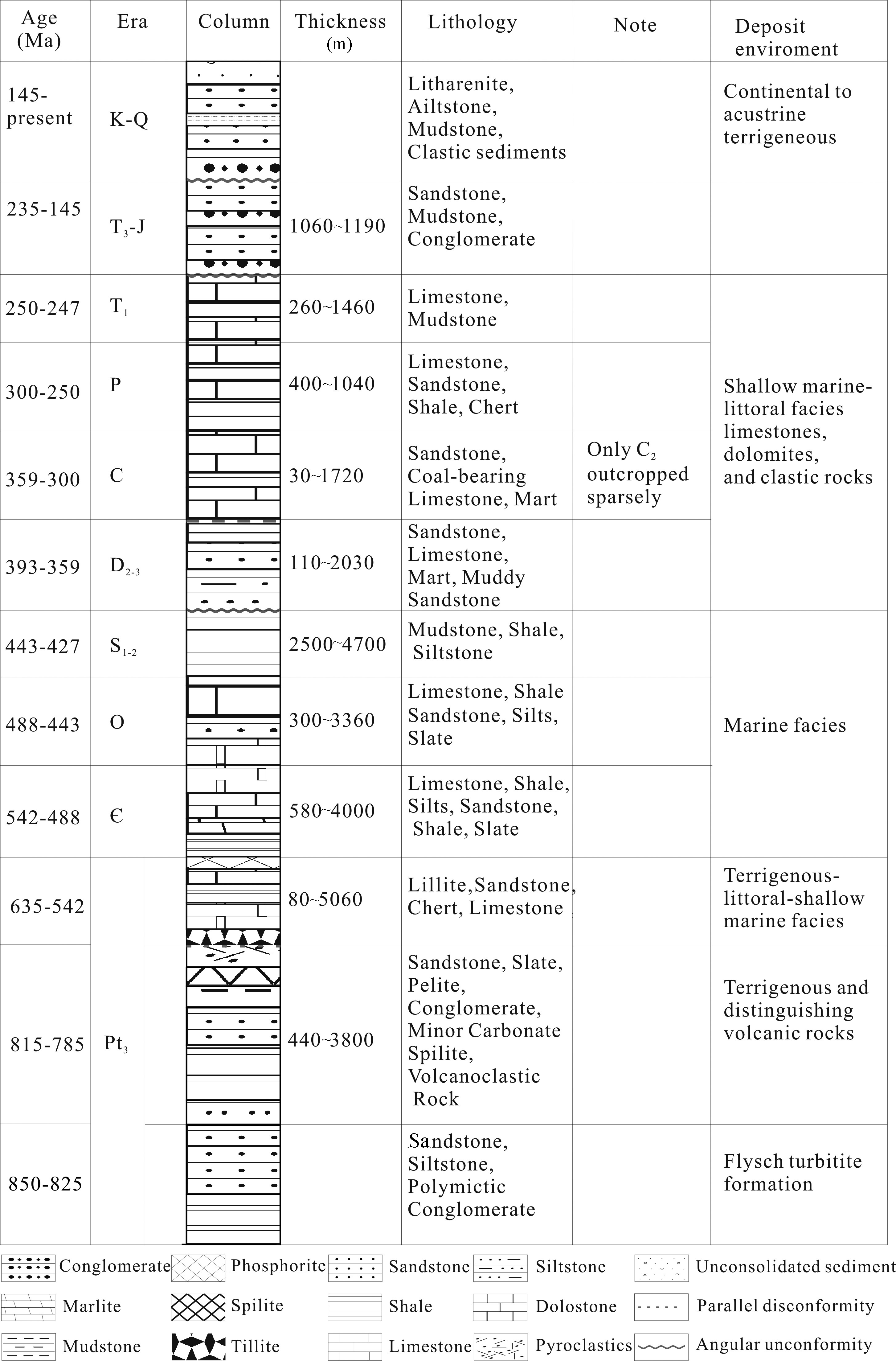
Fig.2 Columnar section showing the ages, lithologies, thickness of stratigraphic units preserved in the Sichuan Basin (compiled from Jia et al., 2006; Ma et al., 2007; Zeng, 2010) |
|
Fig.3 The sketch map of distribution of the deep seismic reflection profiles and wide-angle reflection and refraction profiles around the Sichuan Basin |
In order to study the deep structure and evolution of the South China continent, several deep seismic reflection profiles have been carried out in this region by Lithosphere Research Centre(LRC), the Chinese Academy of Geological Sciences(CAGS). The profiles include the “cross-shape” profiles in Daba region, the profile crossing the Songpan-Garz-e block, Longmen Shan fold-thrust belt, the Sichuan Basin and Xuefeng fold belt from west to east(Dong et al., 2013; Guo et al., 2013; Xiong et al., 2009). The industry seismic profiling in SCB and its adjacent regions can be traced back to 1950s in order to find the distribution of oil-gas. With the discovering of several oil fields, the work was shifted to the southern SCB, the southwestern SCB and the eastern SCB(Yan et al., 2003, 2009; Liu et al., 2012). What is more, the recent occurrence of the natural earthquakes in the Longmen Shan region also prompt the geologists to use the seismic reflection profiling to detect the deep crustal structure and study the earthquake mechanism(Burchfiel et al., 1995; Hubbard et al., 2009; Hubbard et al., 2010; Jia et al., 2010; Li et al., 2013; Liu et al., 2012; Lu et al., 2012; Plesch et al., 2007; Wang et al., 2013b; Yan et al., 2009; Yan et al., 2003; Zhou et al., 2013).
3.2 Moho DepthWe resampled the Moho depth at a spacing of 5~10 km along the wide-angle reflection & refraction profiles, and added the samples near the Moho transition zone. We also obtained the TWT(two-way traveltime)along the deep seismic reflection profiles, and transferred the TWT to depths according to the regional crustal average velocity 6.2 km·s-1. Then we obtained the Moho depth contour map with these sampled data by the Kriginginterpolation(Fig. 4). The result shows that the Moho depth in the Sichuan basin is 40~42 km. The depth deepens to 44~46 km in the northern margin, and shallows to 40 km in the western margin(Xiong et al., 2015).

|
Fig.4 The Moho depth contour map of the Sichuan Basin and adjacent regions (FTB: fold thrust belt) |
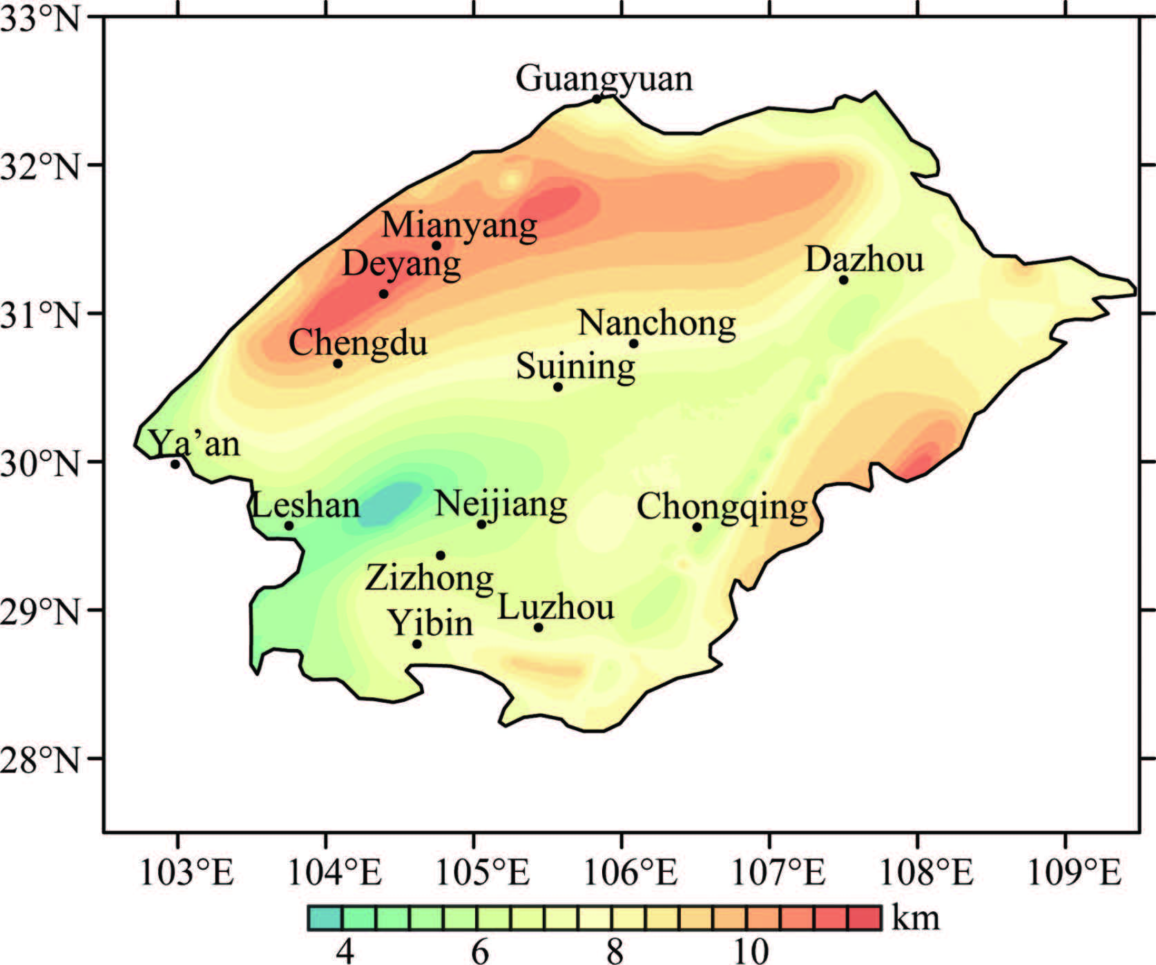
Based on the previous sedimentary thickness contour map(Luo, 1998; Zhang et al., 2012), additional data were provided: the resampled thickness from the new industry seismic profiles and the deep seismic reflection profiles(Burchfiel et al., 1995; Hubbard et al., 2009; Hubbard et al., 2010; Jia et al., 2010; Li et al., 2013; Liu et al., 2012; Lu et al., 2012; Plesch et al., 2007; Wang et al., 2013b; Yan et al., 2009; Yan et al., 2003; Zhou et al., 2013). The thickness was translated from two-way time in accordance with different crustal velocity in different regions, and then we used the Kriging method to interpolate the thickness to form the thickness grid, and then create the sedimentary thickness map with higher resolution contour line. The map shows that there are two deposit centers in the Sichuan basin, located in the Deyang area in the western margin and the Nanchuan area in the eastern margin, where the sedimentary thickness could be 10~12 km; and the deposit centers extend along the northeast-southwest direction. The sediment thickness in the Leshan and Neijiang area in the southwestern part is only 4 km, much thinner than the other areas, reflecting the basement uplift there(Fig. 5; Xiong et al., 2015).
|
Fig.5 The sedimentary cover thickness contour map of the Sichuan Basin |
We calculated the free-air gravity anomalies in Sichuan basin by using the Earth Gravitational Model EGM2008(Sandwell et al., 2009). The EGM2008 is the official version of the higher order earth gravitational model presented by the National Geographic Space Intelligence Agency of America(NGA), with the order to 2159 completely( and the order of the spherical harmonic coefficients is extended to 2190) and the spatial resolution about 5 minutes. Due to the adoption of the GRACE satellite tracking data, satellite altimetry data and ground gravity data, the model presents a great progress in both precision and resolution. The model can reach the accuracy requirement of 1:1000000 scale in marine gravity surveys, and the precision of the anomalies can reach 10 mGal in most parts of China. Hence the model is suitable for marine geological and resource surveys on the medium scale and continental gravity compiling and tectonic studies on the smallmedium scale.
We calculated the free-air gravity anomalies with grid spacing of 10 km in Sichuan Basin by using the EGM2008. And then we performed terraincorrection and Bouguer correction on the free-air anomalies, to obtain the Bouguer gravity anomalies. We then used the preferential filtering method(Guo et al., 2012, 2013)to suppress the high-frequency noise in the data and retain the effective Bouguer gravity anomalies, as shown in Fig. 6. The Bouguer gravity anomaly in the Sichuan Basin presents the features as high in the middle but low in the surround, NE-trending, and the amplitude of –299~–80 mGal, which are consistent with the previous studies(Jiang et al., 2001). The central part of the basin presents NE-trending high anomaly traps, while the edge of the basin presents the gradually decreasing anomalies as well as some beaded or lumpy local high anomalies. These features reflect that in the central basin exists ancient basement uplifting, and the blind fault zone appears to play an important role in the northwest margin of the basin in the middle and lower crust of the basin. In the Longmen Shan fault thrust belt and the southwestern margin of the basin, the low anomalies are presented. The feature reflects that the Moho surface becomes deeper in these areas and the crust gets thicker(Xiong et al., 2015).

|
Fig.6 The gravity anomaly contour map of the Sichuan Basin and adjacent regions |
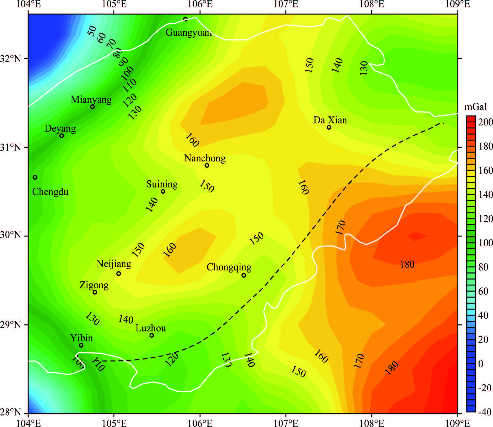
According to the density characteristics of rocks in the Sichuan Basin(Qu, 2008), we chose the average density of the sedimentary cover as 2.55 g·cm-3, the average density of crystalline bedrock as 2.8 g·cm-3, the average density of the lower crust above Moho as 2.9 g·cm-3, and the average density of the upper mantle as 3.3 g·cm-3. Then according to the Moho depth contours(Fig. 4) and the basement depth contours(Fig. 5), we forwardly calculated the gravity anomalies of both the Moho surface and the sediment cover by using frequency domain modeling method(Parker, 1973). We then stripped both above two anomalies from the denoised Bouguer gravity anomalies(Fig. 6) and finally obtained the residual gravity anomalies shown in Fig. 7. They reflect the inhomogeneous density distribution of the middle-lower crust of the basin. The results show that the residual gravity anomalies in the basin are characterized by blocks in East-West and of the amplitude of –32~206 mGal. To the west of the Chongqing-Huaying line, two high gravity anomaly traps are presented respectively in the north and south. The high traps centered at Neijiang, Suining, Nanchong and Dazhou with a striking of NE direction and the values up to 170 mGal. However, to the east of the line, only one high gravity anomaly trap is presented, which is NNE-trending with the amplitude up to 190 mGal(Fig. 7). Therefore, the characteristics of the residual gravity anomalies are different between the west and east sides of the Chongqing-Huaying line. From east to west, the traps become narrow and the axial features of these traps differ from each other, indicating that the crustal structures are different between the two sides. The Chongqing-Huaying line is the contact zone of the high traps on both sides. The anomalies along this line are relatively low and trend in the NE direction, reflecting a possible blind fault zone in the subsurface, which separated the ancient continent around this line into two different oldl and s.
|
Fig.7 The middle-lower crustal gravity anomaly of the Sichuan Basin and adjacent regions The black dash line indicates the distinctive difference between the western and eastern parts. |
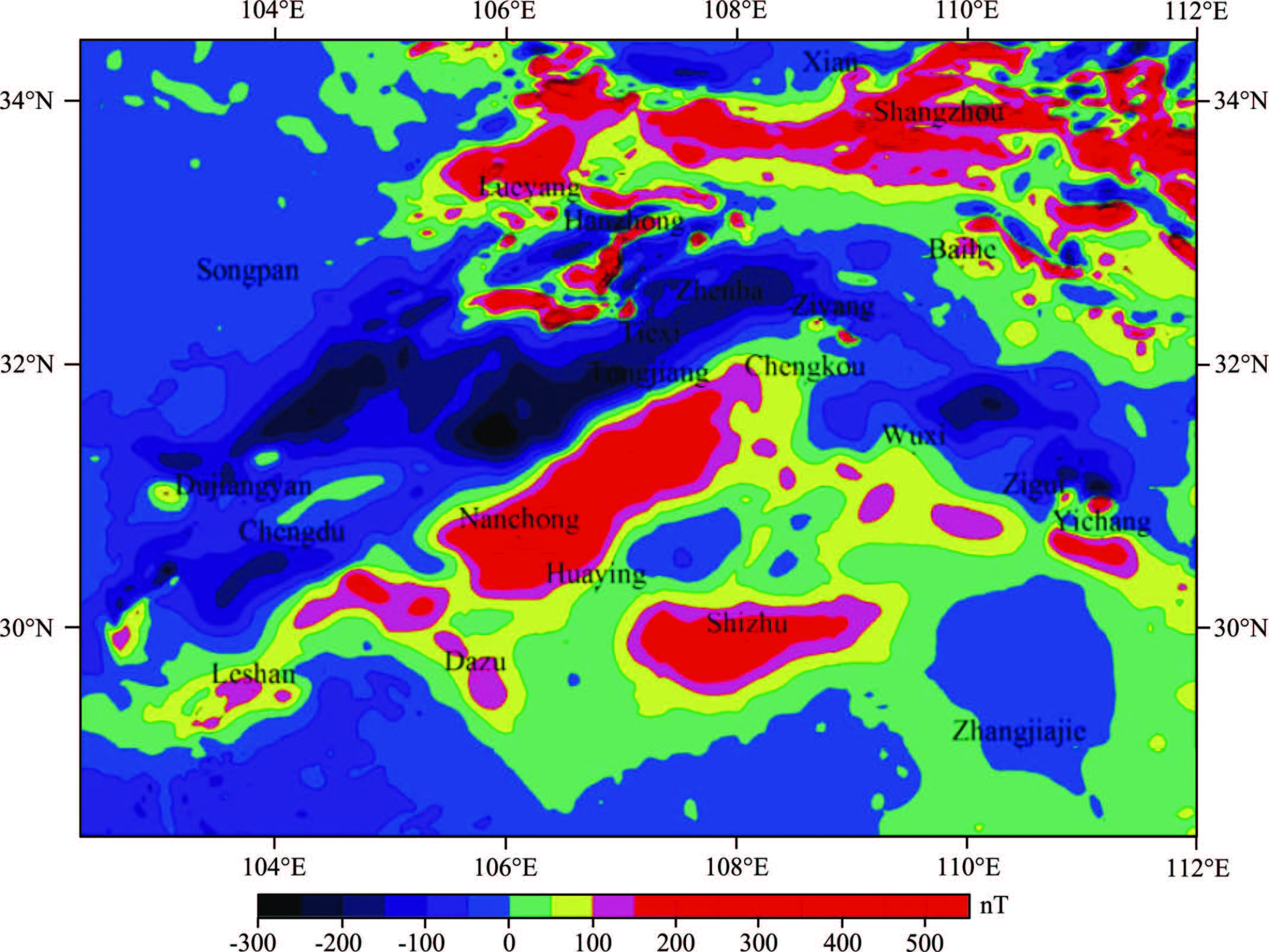
The result of the gravity anomaly shows that the middle-lower crust of the Sichuan Basin could be divided into eastern and western parts, which reflect that the basement of the two parts was different before the sedimentation of Nanhua system. The aeromagnetic anomaly presents the difference between the observational magnetic intensity and the ambient field, which highlights the distribution characteristics of regional anomaly, and reflects the main regional structures. The result of the aeromagnetic anomaly showed that the basement of the Sichuan Basin is heterogeneous on the whole(Fig. 8; Zhang et al., 2013; Gu and Wang, 2014; Gu et al., 2014): the region to the west of the Chongqing-Huaying line has a high aeromagnetic anomaly centered in Nanchong and Dazhou, while the region to the east has a high aeromagnetic anomaly centered in Shizhu. The positive aeromagnetic anomalies usually reveal the regional structure of the metamorphosed basement. Therefore, the aeromagnetic anomalies also indicated that the basement of the Sichuan Basin is not coherent(Gu and Wang, 2014).
|
Fig.8 Aeromagnetic anomaly in the East Sichuan fold belt and periphery areas (Zhang et al., 2013) |
|
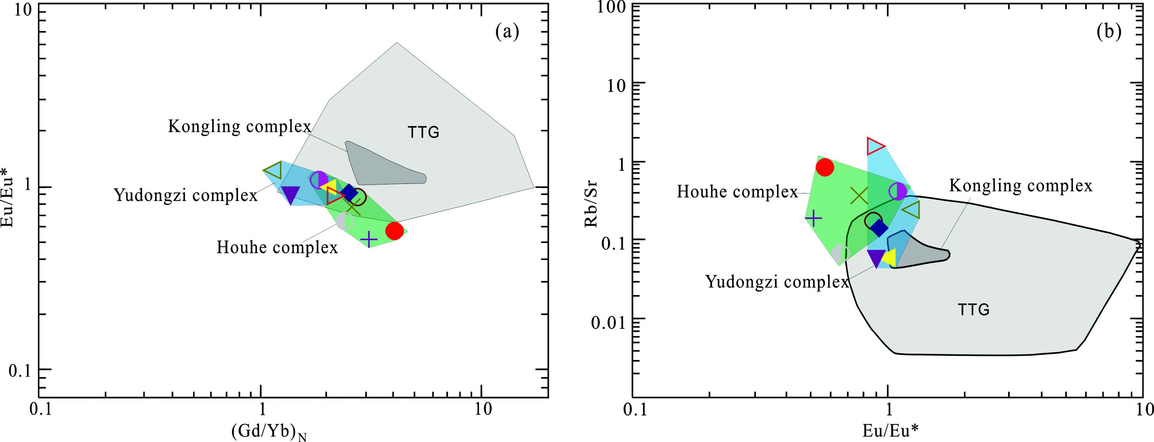
Fig.9 The Eu/Eu*vs. (Gd/Yb)N (a) and Rb/Sr vs. Eu/Eu* (b) diagrams of Archean-Paleoproterozoic complexes in east and west Yangtze blocks The Yudongzi and Houhe complexes (West part) show typical calk-alkaline granitoids, while Kongling complex shows TTG characteristics. The Yudongzi complex field is from Zhang et al. (2001), the Houhe complex field is from Wu et al. (2012), the Kongling TTG field is fromGao et al. (1999) and Zhang et al. (2006b), while the Global TTG field is from Kemp and Hawkesworth (2005). |
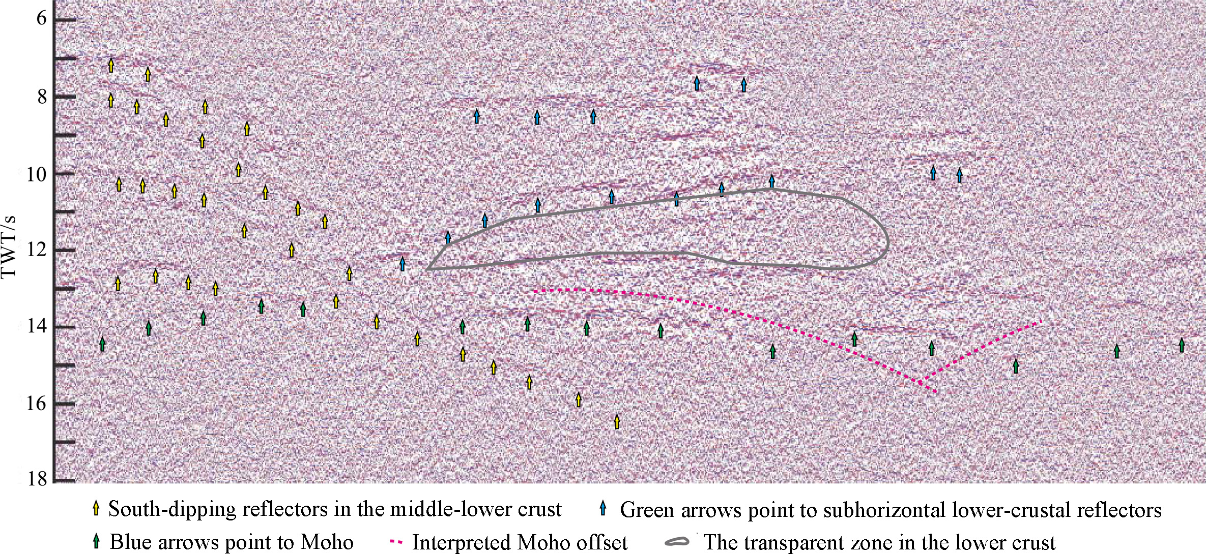
The Paleoproterozoic gneisses reported in the western part of the Yangtze block indicated that the Kongling complex outcropped in the northeastern margin of the Sichuan Basin shows TTG characteristics(Gao et al., 1999; Zhang et al., 2006b), while the Houhe and Yudongzi complexes outcropped in the northwestern margin of the Sichuan Basin show calc-alkali isl and -arc characteristics(Wu et al., 2012; Zhang et al., 2001). This difference also implies that there are two different old nucleuses with different basement material in the western and eastern parts of the Sichuan Basin. The new deep seismic reflection profile crossing the East Sichuan fold belt revealed a set of reflectors extending from middle-lower crust to mantle(Fig. 10). Slanting reflections from mid-lower crust to upper mantle beneath the Phanerozoic and Proterozoic cover are generally considered as originated at the upper surface of an eclogitic slab embedded in the mantle by subduction(Morgan et al., 1994), or arisen from a shear zone created by thrusting of a lower plate down into the mantle(Calvert et al., 1995). Therefore, the set of reflectors extending from middle-lower crust to mantle may indicate an arc-continent collision event occurred in the upper-middle Yangtze block before Neoproterozoic.
|
Fig.10 The main middle-lower crustal reflectors of the deep seismic profile across the East Sichuan fold belt (location is seen in Fig. 1) |
We obtained the sedimentary thickness and Moho depth contours after resampling and interpolating the seismic data in the Sichuan Basin and adjacent regions, then we obtained the residual gravity anomaly after stripping the gravity anomaly caused by the Moho and sedimentary covers. The residual gravity anomaly presents the density distribution of the middle-lower crust of the basin. The result shows that the middle-lower crustal structure is different on the two sides of the Chongqing-Huaying line. Combined with the aeromagnetic, the geochemical properties of the basement complexes outcropped, and the deep seismic reflection data, we inferred that there are two continental nucleuses beneath the upper-middle Yangtze block.
ACKNOWLEDGMENTSThis paper was funded by the National Natural Science Foundation of China(41104056, 41374093, 41274097, 41574093) and basic scientific research fund of Institute of Geology, Chinese Academy of Geological Sciences(J1119).
| [1] | Bao C, Yang X J, Li D X. 1985. Characteristics of geological structure and predication of gas prospect of Sichuan basin. Natural Gas Industry (in Chinese), 5(4): 1-11. |
| [2] | Burchfiel B C, Chen Z L, Liu Y, et al. 1995. Tectonics of the Longmen Shan and adjacent regions, Central China. International Geology Review, 37(8): 661-735. |
| [3] | Calvert A J, Sawyer E W, Davis W J, et al. 1995. Archaean subduction inferred from seismic images of a mantle suture in the Superior Province. Nature, 375(6533): 670-674. |
| [4] | Cao J M,Wang Y X. 1997. Crustal velocity structure of Maowen-Shaoyang segment of Altyn-Taiwan profile. //Geoscience Transect in ALty-Taiwan (in Chinese). Beijing: China University of Geosciences Press, 82-86. |
| [5] | Chen X B, Wu Y Q, Du P S, et al. 1988. Crustal veolocity structure in the two sides of the Longmenshan tectonic belt. //The Deep Structure Research and Progress of China Continent (in Chinese). Beijing: Geological Publishing House, 97-113. |
| [6] | Gao S, Ling W L, Qiu Y M, et al. 1999. Contrasting geochemical and Sm-Nd isotopic compositions of Archean metasediments from the Kongling high-grade terrain of the Yangtze craton: Evidence for cratonic evolution and redistribution of REE during crustal anatexis. Geochimica et Cosmochimica Acta, 63(13-14): 2071-2088. |
| [7] | Greentree M R, Li Z X. 2008. The oldest known rocks in south-western China: SHRIMP U-Pb magmatic crystallisation age and detrital provenance analysis of the Paleoproterozoic Dahongshan Group. Journal of Asian Earth Sciences, 33(5-6): 289-302. |
| [8] | Gu Z D, Wang Z C. 2014. The discovery of Neoproterozoic extensional structures and its significance for gas exploration in the Central Sichuan Block, Sichuan basin, South China. Science China: Earth Sciecens, 57(11): 2758-2768. |
| [9] | Gu Z D, Zhang W, Yuan M. 2014. Zircon SHRIMP U-Pb dating of basal granite and its geological significance inWeiyuan area of Sichuan Basin. Chinese J. Geology (in Chinese), 49(1): 202-213. |
| [10] | Guo L H, Meng X H, Shi L, et al. 2012. Preferential filtering method and its application to Bouguer gravity anomaly of Chinese continent. Chinese J. Geophys. (in Chinese), 55(12): 4078-4088, doi: 10.6038/j.issn.0001-5733.2012.12.020. |
| [11] | Guo L H, Meng X H, Chen Z X, et al. 2013. Preferential filtering for gravity anomaly separation. Computers & Geosciences, 51: 247-254. |
| [12] | Hubbard J, Shaw J H. 2009. Uplift of the Longmen Shan and Tibetan plateau, and the 2008 Wenchuan (M=7.9) earthquake. Nature, 458(7235): 194-197. |
| [13] | Hubbard J, Shaw J H, Klinger Y. 2010. Structural setting of the 2008 MW7.9 Wenchuan, China, earthquake. Bulletin of the Seismological Society of America, 100(5B): 2713-2735. |
| [14] | Jia D, Wei G Q, Chen Z X, et al. 2006. Longmen Shan fold-thrust belt and its relation to the western Sichuan Basin in central China: New insights from hydrocarbon exploration. AAPG Bulletin, 90(9): 1425-1447. |
| [15] | Jia D, Li Y Q, Lin A M, et al. 2010. Structural model of 2008 MW7.9 Wenchuan earthquake in the rejuvenated Longmen Shan thrust belt, China. Tectonophysics, 491(1-4): 174-184. |
| [16] | Jiang W W, Liu Y K, Hao T Y, et al. 2001. Comprehensive study of geology and geophysics of Sichuan Basin. Progress in Geophyscs (in Chinese), 16(1): 11-23. |
| [17] | Jiao W F, Wu Y B, Yang S H, et al. 2009. The oldest basement rock in the Yangtze Craton revealed by zircon U-Pb age and Hf isotope composition. Science in China Series D: Earth Sciences, 52(9): 1393-1399. |
| [18] | Kemp A I S, Hawkesworth C J. 2005. Granitic perspectives on the generation and secular evolution of the continental crust. //The Crust. Oxford: Elsevier-Pergamon, 3: 349-410. |
| [19] | Li Z G, Jia D, Chen W. 2013. Structural geometry and deformation mechanism of the Longquan anticline in the Longmen Shan fold-and-thrust belt, eastern Tibet. Journal of Asian Earth Sciences, 64: 223-234. |
| [20] | Liu S G, Deng B, Li Z W, et al. 2012. Architecture of basin-mountain systems and their influences on gas distribution: A case study from the Sichuan basin, South China. Journal of Asian Earth Sciences, 47: 204-215. |
| [21] | Lu R Q, He D F, Suppe J, et al. 2012. Along-strike variation of the frontal zone structural geometry of the Central Longmen Shan thrust belt revealed by seismic reflection profiles. Tectonophysics, 580: 178-191. |
| [22] | Ma Y S, Guo X S, Guo T L, et al. 2007. The Puguang gas field: New giant discovery in the mature Sichuan Basin, southwest China. AAPG Bulletin, 91(5): 627-643. |
| [23] | Morgan J V, Hadwin M, Warner M R, et al. 1994. The polarity of deep seismic reflections from the lithospheric mantle: Evidence for a relict subduction zone. Tectonophysics, 232(1-4): 319-328. |
| [24] | Parker R L. 1973. The rapid calculation of potential anomalies. Geophysical Journal International, 31(4): 447-455. |
| [25] | Plesch A, Shaw J H, Kronman D. 2007. Mechanics of low-relief detachment folding in the Bajiaochang field, Sichuan Basin, China. AAPG Bulletin, 91(11): 1559-1575. |
| [26] | Qiu Y M, Gao S, McNaughton N J, et al. 2000. First evidence of >3.2 Ga continental crust in the Yangtze craton of south China and its implications for Archean crustal evolution and Phanerozoic tectonics. Geology, 28(1): 11-14. |
| [27] | Qu W Y. 2008. A forward and inversion study on the main density interfaces in Sichuan basin [Master's thesis] (in Chinese). Xi'an: Northwest University. |
| [28] | Sandwell D T, Smith W H. 2009. Global marine gravity from retracked Geosat and ERS-1 altimetry: Ridge segmentation versus spreading rate. Journal of Geophysical Research: Solid Earth (1978-2012), 114(B1). |
| [29] | Wang C Y, Wu J P, Lou H, et al. 2003. P-wave crustal velocity structure in western Sichuan and eastern Tibetan region. Science in China Series D: Earth Sciences, 46(2S): 254-265. |
| [30] | Wang L J, Griffin W L, Yu J H, et al. 2013a. U-Pb and Lu-Hf isotopes in detrital zircon from Neoproterozoic sedimentary rocks in the northern Yangtze Block: Implications for Precambrian crustal evolution. Gondwana Research, 23(4): 1261-1272. |
| [31] | Wang M, Jia D, Shaw J H, et al. 2013b. Active Fault-Related Folding beneath an Alluvial Terrace in the Southern Longmen Shan Range Front, Sichuan Basin, China: Implications for Seismic Hazard. Bulletin of the Seismological Society of America, 103(4): 2369-2385. |
| [32] | Wang Y X, Mooney W D, Han G H, et al. 2005. Crustal P-wave velocity structure from Altyn Tagh to Longmen mountains along the Taiwan-Altay geoscience transect. Chinese J. Geophys. (in Chinese), 48(1): 98-106. |
| [33] | Wu Y B, Gao S, Zhang H F, et al. 2012. Geochemistry and zircon U-Pb geochronology of Paleoproterozoic arc related granitoid in the Northwestern Yangtze Block and its geological implications. Precambrian Research, 200-203: 26-37. |
| [34] | Xiong S B, Zheng Y, Yin Z X, et al. 1993. The 2-D structure and it's tectonic implications of the crust in the Lijiang-Panzhihua-Zhehai region. Chinese J. Geophys. (in Chinese), 36(4): 434-444. |
| [35] | Yan D P, Zhou M F, Song H L, et al. 2003. Origin and tectonic significance of a Mesozoic multi-layer over-thrust system within the Yangtze Block (South China). Tectonophysics, 361(3-4): 239-254. |
| [36] | Yan D P, Zhang B, Zhou M F, et al. 2009. Constraints on the depth, geometry and kinematics of blind detachment faults provided by fault-propagation folds: An example from the Mesozoic fold belt of South China. Journal of Structural Geology, 31(2): 150-162. |
| [37] | Yin Z X, Xiong S B. 1992. Explosion seismic study for the 2-D crustal structure in Xichang-Dukou-Muding region. Chinese J. Geophys. (in Chinese), 35(4): 451-458. |
| [38] | Zeng L B. 2010. Microfracturing in the Upper Triassic Sichuan Basin tight-gas sandstones: Tectonic, overpressure, and diagenetic origins. AAPG Bulletin, 94(12): 1811-1825. |
| [39] | Zhang J S, Gao R, Li Q S, et al. 2013. Characteristic of gravity and magnetic anomalies in the Daba Shan and the Sichuan basin, China: Implication for Architecture of the Daba Shan. Acta Geologica Sinica-English Edition, 87(4): 1154-1161. |
| [40] | Zhang S B, Zheng Y F, Wu Y B, et al. 2006a. Zircon isotope evidence for ≥3.5 Ga continental crust in the Yangtze craton of China. Precambrian Research, 146(1-2): 16-34. |
| [41] | Zhang S B, Zheng Y F, Wu Y B, et al. 2006b. Zircon U-Pb age and Hf-O isotope evidence for Paleoproterozoic metamorphic event in South China. Precambrian Research, 151(3-4): 265-288. |
| [42] | Zhang Z Q, Zhang G W, Tang S H, et al. 2001. On the age of metamorphic rocks of the Yudongzi group and the Archean crystalline basement of the Qinling orogen. Acta Geologica Sinica (in Chinese), 75(2): 198-204. |
| [43] | Zhao G C, Cawood P A. 2012. Precambrian geology of China. Precambrian Research, 222-223: 13-54. |
| [44] | Zheng J P, Griffin W L, O'Reilly S Y, et al. 2006. Widespread Archean basement beneath the Yangtze craton. Geology, 34(6): 417-420. |
| [45] | Zhou M F, Yan D P, Wang C L, et al. 2006. Subduction-related origin of the 750 Ma Xuelongbao adakitic complex (Sichuan Province, China): Implications for the tectonic setting of the giant Neoproterozoic magmatic event in South China. Earth and Planetary Science Letters, 248(1-2): 286-300. |
| [46] | Zhou R J, Li Y, Svirchev L, et al. 2013. Tectonic mechanism of the Suining (MS5.0) earthquake, center of Sichuan Basin, China. Journal of Mountain Science, 10(1): 84-94. |
 2015, Vol. 58


