 2015, Vol. 58


2. Qingdao Institute of Marine Geology, Qingdao 266071, China
Since the Cenozoic, intensive plate interactions have created distinct tectonic terrain, huge contrast of topographic relief and various kinds of l and forms in East Asia, especially the trench-arc-basin system characterizes the active continental margin. In general, the features of geomorphology are dependent on many geologic conditions such as tectonic units, regional geological structures, lithology, and neotectonic movement. Tectonic geomorphology is a marginal discipline among geomorphology, geodynamics, and structural geology, which studies formation processes and development regularities of tectonic l and forms(including relevant sediments), infers features of crustal movement under certain tectonic stress fields, and solves problems for practical application(Morisaws and Hack, 1985; Han, 1982).
In the early 1930s, Li Siguang pointed out that the topography in China mainl and is high in west and low in east, exhibiting a pattern of three-step l and forms(Lee, 1939; Jiang et al., 1993), which has long been concerned by geologic, geographic, biologic, and meteorological communities. By the 1980s, Sun and Wu(1986)further suggested that the evolution of the natural environment is controlled by both the tectonic movement and climate change, and the rhythm of neotectonic movement is closely related with periodicity of climate change in China mainl and . Using the modern atmospheric circulation models, some American researchers have simulated the ancient atmospheric circulations at varied elevations in mid-latitude mountains and plateaus of the north hemisphere, particularly during uplift of the Tibetan Plateau. Their results demonstrate that the topographic rise, which is most remarkable in the Tibetan Plateau, is the primary driving force for climate change in the north hemisphere since the late Cenozoic(Ruddiman, 1989a, 1989b; Kutzbach, 1989).
The preparation of the geological and geophysical maps in China mainl and and seas was guided by the theory of block tectonics(Liu, 1990, 1992, 1993; Zhang, 2008, Zhang et al., 2008, 2009; Zhang and Guo, 2014), which was proposed based on the academic thoughts of Zhu Xia and Liu Guangding. This theory summarizes the evolution of the topography in China mainl and and seas as a “seesaw model”. It means that from the late Paleozoic to Jurassic, thin crust and low terrain characterized western China, while eastern China had high topography; since the Eogene, the crust of western China was thickened by strong compression, leading to rising topography, while the crust of eastern China was thinned due to extension in the Pacific, resulting in low terrains; such processes were like the motion of a huge seesaw with the axis along Ordos-Sichuan(Liu, 2007).
2 EVOLUTION OF TOPOGRAPHYTopography refers to ground relief of the earth's surface, which is the result from joint functions of forces inside and outside the earth as well as the surficial expression of structure, tectonics, constitution and development within the earth. The formation and evolution of the tectonic pattern in China mainl and and seas determined the general trend of its topography.
2.1 Formation and Evolution of the Tectonic Pattern in China Mainl and and SeasThe formation and evolution of the tectonic pattern in China mainl and and seas were associated with the spreading and closing of oceans in each period as well as collision and assemblage between tectonic blocks, and were divided by the Indosinian period. Prior to this period, the earth was in the ancient global tectonic stage. During the pre-Cambrian time, many continental nucleuses, such as the North China, Yangtze, South China, and Tarim blocks, appeared in the Tethys ocean, which grew into relatively stable cratons, without interaction between them, described as a geosynclines-platform regime. By the end of the Paleozoic, these blocks were assembled into the China mainl and , entering into the plate regime stage, then the Tibetan Plateau did not exist yet(Zhang, 2008; Zhang et al., 2008; 2009; Zhang and Guo, 2014).
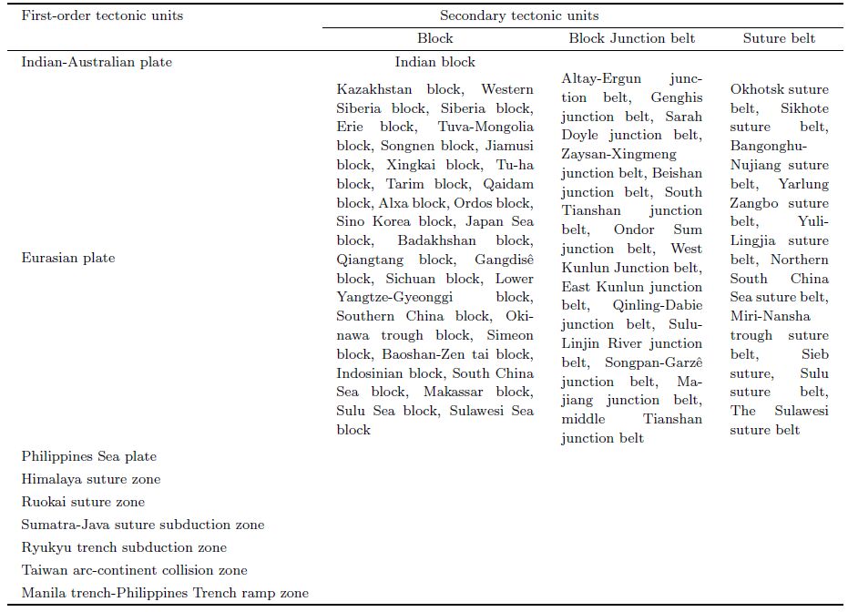
2.1.1 Subdivision of tectonic unitsThe mobility is the connotation of the theory of block tectonics(Zhang et al., 2008). According to this theory, the China mainl and and seas and adjacent areas are divided into three plates: Eurasian, Philippine Sea, and India-Australia plates, 6 boundary belts including suture zone, subduction zone, collision zone and ramp zone. Within the Eurasian plate, from north to south, there are 29 blocks, 14 junction zones and 10 suture zones defined(Huang et al., 1977; Liu, 2007; Zhang et al., 2010; Zhang and Guo, 2014, Guo et al., 2014)(Table 1).
| Table 1 Tectonic units of China seas and l and and adjacent areas(Guo et al., 2014) |
Increasing studies suggest that there was once a united super continent on the earth 1000 Ma ago, called the Rodinia. It was broken up about 700 Ma ago, forming several continents. Later they were assembled again, forming another super continent during the Permian, i.e. the Pangea. This ancient l and was bisected into the Laurasia in the north and Gondwana in the south during the Jurassic.
In the early Paleozoic, most continents of the earth lay nearby the equator or in the south hemisphere, arranged roughly in EW direction along latitude. In the Paleozoic, the groups of small-size continent blocks of China and adjacent regions remained among the Laurasia, Siberia, and Gondwana continents(Wan and Zhu, 2007). In most of this period, all these blocks moved over small distances, overall in a discrete state, and were situated in a tropical-subtropical climate environment nearby the equator(Yin and Lu, 2006). In the early Paleozoic, the North China, Yangtze and Tarim blocks were all located at middle latitudes in the south hemisphere, closely related with the Gondwana continent.
2.1.3 Tectonic evolution since the Indosinian movementFrom the middle Triassic to the early Jurassic, the Indosinian movement had a great impact on the paleogeographic environment of China. During that period, the major blocks of China mainl and converged and collided with each other(Wan, 2004), leading to significant change of the tectonic and geographic patterns, and amalgamation of the North China, Yangtze, Tarim and Qaidam blocks(Fig. 1). After the Triassic, the western part of the Tethys ocean became narrow or even closed, while its eastern part remained open. This old ocean separated the Gondwana in the south and the Laurasia in the north, also called the ancient Mediterranean Sea(the modern Mediterranean Sea is its relict).

|
Fig.1 Reconstructed continents in the Late Triassic (Hou et al., 2014) |
After the Indosinian movement, the development of paleogeography and paleotectonics entered a new stage, i.e. the Yanshanian movement. This event was the most intensive one during the late Jurassic to Early Cretaceous leaving widespread effects. By the late Jurassic, the amalgamation between the eastern China mainl and and Siberia block had not completed yet, volcanic activities were intensive, terrestrial volcanic debris mostly deposited. Inl and basins were widely developed in the north China and western China mainl and , with dominant fluviolacustrine clastic deposits(Wan and Zhu, 2002). The southeastern Yangtze block was an area with active volcanoes and tectonic activity, covered with large-area volcanic rocks(Shang et al., 1999). During this period, the Gangdisê block had not yet accreted onto the Eurasia, though very close to the Qiangtang block, both were largely covered by sea water, deposited a set of clastic rocks and carbonate rocks of neritic facies(Wang and Zhong, 2002).
By the Cretaceous period, except the Himalayas remained in a shallow sea north of India, the convergence process of other blocks in China mainl and had finished(Fig. 2). Paleomagnetic data indicate that the magnetic declinations of the North China and Tarim were not close until Jurassic, implying the convergence and suturing between the two blocks completed at the Jurassic. Meanwhile the Qiangtang block had already accreted upon the Eurasia continent, and a suite of conglomerate of the Jingzhushan formation and Abushan formation deposited in the Gangdisê and Qiangtang blocks, respectively(He et al., 2006). It indicates that these two blocks had completely amalgamated together, entering an intensive continent-continent orogeny(Yin et al., 1994; Murohy et al., 1997; Murphy and Harrison, 1999). It is commonly assumed that the suture between these two blocks, Gangdisê and Qiangtang, is along the Nujiang-Bangong junction zone. From the early Cretaceous to late Cretaceous, although the sea covering Gangdisê and Qiangtang was gradually shrinking, the west of both remained under water, and received detrital and carbonate deposits of neritic facies(Yin et al., 1988). By the end of the Cretaceous, sea water retreated from the Alpine in southern Europe and southeast Asia. From the end of the Oligocene to Miocene, the Himalayan region rose to become l and ; while the Himalayan movement began when the eastern section of the ancient Mediterranean Sea disappeared(Huang and Chen, 1987; Sengor, 1989; Kazmin et al., 1991; Luo, 1995).

|
Fig.2 Reconstructed continents in the Late Cretaceous(Hou et al., 2014) |
In the Eogene, the paleo-latitudes of the Tarim, Yangtze, North China, Qaidam, and Qiangtang blocks were very close to those at present with largely same magnetic poles, only slightly differing for the Gangdisê block. These data are consistent between the Himalayan and India blocks, with small differences compared to the Gangdisê block, indicative of the initial collision between the Himalaya-India and Gangdisê blocks. The plaeo-magnetic data of the North China and Yangtze blocks for the Eogene period are largely consistent, implying both had no apparent movement during that time(Fig. 3). The small differences in paleo-magnetic data of the Tarim block are probably due to crustal shortening by intracontinental compression(Zhu et al., 1998). The rapid uplift of the Tibetan Plateau began from the end of the Pliocene epoch(Li et al., 1979). The study on paleo-magnetic anomalies in the Indian ocean(Patriat and Achache, 1984)suggested that the India-Eurasia plate collision commenced about 50 Ma ago, culminating at 45 Ma, which fuelled up the relative motions between the blocks in western China and adjacent areas as well as that between these blocks and the Eurasia continent, as expressed by NS- and EW-directed compression, thickening of crust or lithosphere, and large-scale lateral slip within the continent(Wu et al., 2002).

|
Fig.3 Reconstructed continents in the Paleogene(Hou et al., 2014) |
Throughout the Phanerozoic time, the China mainl and experienced break up, drift, and convergence of multiple blocks. By Neogene, when the Indian plate collided with the Eurasia plate, the amalgamation process of those blocks in China mainl and finally ended, forming the current pattern of a unified continent. However, continental tectonic deformation and local motions still continue.
2.2 Evolution of Topography200 Ma ago, the Pangea and Panthalassa occupied the surface of the earth(Morel and Irving, 1981). At that time, the India and Pacific plates did not pose any force directly on the Eurasia plate. The China mainl and was in a state of stress relaxation, where the long-term surface erosion resulted in extensive planation and peneplanation, leaving the oldest planation surface seen at present. The trench-arc-basin system in the West Pacific was not shaped yet(Liu, 1992).
In the Jurassic, the paleogeographic outline of China mainl and largely kept its face in the late Triassic that was featured by “east-west differential, high in east and low in west”. Due to the effect of the Indosinian movement, the Garzê trough disappeared and l and area exp and ed to the current Yellow Sea and East China Sea. By the late Jurassic, the l and form differentiation became clear in China mainl and with some distinguished mountain ranges.
Compared with the present-day, the most remarkable difference of l and and sea distribution in the Cretaceous was the existence of an EW-trending broad Tethys ocean in the regions of low latitudes, while the Atlantic and Indian oceans were in the initial stage of formation(Hay et al., 1989). From the end of the Cretaceous to the early Eogene, the Indian plate collided with the Eurasian plate, and the Tethys ocean retreated gradually from the western China mainl and which was situated between two rigid blocks of Indian subcontinent and Siberia. Thus the whole western China mainl and experienced crustal shortening and thickening, and was completely out of the marine environment. The eastern China mainl and was a geologically active region because it was close to a transform plate boundary of the West Pacific. The crust moved consequently and extended toward east, creating a series of fault-depression basins. Also during this time, the South China Sea(SCS)began to spread and the western Philippine Sea formed. The intensive collision of the Indian plate and the Eurasian plate made the Tibetan Plateau rise up rapidly, and the continual northward motion of the Indian plate posed further compression and led to the growth of Tibetan Plateau. In the Miocene, the Himalaya was uplifted intensively, followed by the rising of the Qilian Mountain, which constitute the northern and southern edges of the current Tibetan Plateau.
The Pacific plate subducted below the Eurasian plate in NWW direction during the period from the late Oligocene to the early Miocene. From the late Miocene to Pliocene, the Ryukyu trench, isl and s arc and Okinawa trough(back-arc basin)were in the outset of development. Due to the compression of the Pacific plate on the Eurasian plate, the stress field of the eastern China mainl and changed, thus the crustal extension ceased. Consequently, the contiguous fault-depression basins formed a whole down-warping region filled with thick sediments, creating a vast plain. The south China region was uplifted as a whole during this period, where intermountain red basins were cut by rivers and streams leaving numerous red hills.
From the late Pliocene to the early Pleistocene, the continued convergence of the Indian plate and Eurasian plate accelerated the uplift of the Tibetan Plateau(Wang and Ding, 1998; Cui et al., 2001; Zhang et al., 2010). Meanwhile, plate boundary collision occurred at Taiwan resulting in rapid uplift of the central mountain range with river incision and formation of multiple-step terraces there.
In the Eogene, North China and South China shared similar geomorphic patterns, which did not change till the Neogene. Because the North China block has an older and more rigid basement with respect to the South China block, the former subsided as a whole and the latter uplifted in its entirety under compression from the two plates. Another reason for this difference is that South China is close to Taiwan, probably being subject to strong compression from the east.
From the statements above, the ages of the formation of l and forms in eastern China correspond to those tectonic events at plate boundaries. The recent geomorphic outlines of China mainl and and seas and adjacent areas are the results of long-term development and variations of plate motions, representing the last episode of plate evolution.
3 FEATURES OF GEOMORPHOLOGY 3.1 General Features of GeomorphologyIn recent years, the special project of marine geological survey has acquired a wealth of data on seafloor topography with high precision and whole coverage. In combination with gravity data, we have studied the geomorphic features of seafloor of China seas. Then based on the three-step geomorphology proposed by Li Siguang, we study the China mainl and and seas as a whole. Its general features of geomorphology can be summarized as a five-step descent from the Tibetan Plateau in the northwest to the central oceanic basin of the South China Sea in the southeast(Fig. 3). From west to east, the boundaries between these steps are the Kunlun Mountain-Altun Mountain-Qilian Mountain-Hengduan Mountain ranges, the Da Hinggan Ling Mountains-Taihang Mountain-Wushan Mountain-Xuefeng Mountain ranges, the outer margin of the East China Sea shelf(200 m bathymetric line), and the rim of the South China Sea basin.
The Tibetan Plateau towers in western China with an average elevation of 4000~5000 m above sea level, and is the highest topographic step in China. It is surrounded by many big mountains, with the Himalayas on the south as the highest in the world, over 6000 m on average. To the north, the plateau is bounded by the Kunlun Mountain, Altun Mountain, and Qilian Mountain ranges, while the Minshan Mountain, Qionglai Mountain and Hengduan Mountain ranges extend in the east.
Outside the Tibetan Plateau, the topography declines rapidly toward north and east. East to the plateau and bounded by the Da Hinggan Ling Mountains-Taihang Mountain-Wushan Mountain-Xuefeng Mountain ranges, the l and is the second terrain step of China mainl and , including broad plateaus and basins with some big mountains intervening. The largest inl and basin, Tarim, lies in the northwest abutting the Tibetan Plateau with average elevation 1000 m. Further to north is the Junggar basin, mostly 500 m high above sea level. Between these two big basins, the Tianshan Mountains stretch in EW direction, 4000~5000 m high, with many intramountain basins. Northeast of the Tibetan Plateau, connecting the north piedmont of the Qilian Mountain, are the Hexi Corridor and Alxa Plateau of 1000~1500 m elevation. East to the eastern margin of the Tibetan Plateau, from north to the south, some plateaus are distributed in the second terrain step, i.e. the Inner Mongolia, Ordos, Loessial Plateau, and Yunnan-Guizhou Plateau, of which the elevation varies in 1000~2000 m, containing many 1500~2500 m-high mountains, such as the Yinshan Mountain, Liupan Mountain, L¨uliang Mountain, Qinling Mountain, Daba Mountain, Dalou Mountain, Wuling Mountain, and Miaoling Mountain, with few peaks exceeding 3000 m. Besides, the elevation of the Sichuan basin is rather low, mostly less than 500 m.
East of the second terrain step, plains, hills and low mountains dominate the l and . From north to south, they are the Northeast plain, North China plain, and middle-lower Yangtze plain, generally less than 200 m in elevation. South of the Yangtze River there are low mountains and hills with elevations mostly less than 500 m. Further to the east lie a series of NEE trending mountains such as the Changbai Mountain, Qianshan Mountain, Luzhong(central Sh and ong)mountains, and the Xianxialing Mountain, Wuyi Mountain, and Daiyun Mountain that extend along the coast of Zhejiang and Fujian Province. We regard the continental shelf of the offshore areas, i.e. the sea with <200 m bathymetric lines and the third terrain step in eastern China mainl and as a whole, i.e. the new third terrain step. The shelf is the extension of the l and into the sea with water depth 100~200 m and width 400~600 km(Xu et al., 1997). The Bohai Sea has a flat floor, which tilts from the Liaodong Bay, Bohai Bay, and Laizhou Bay to the Bohai Strait, with average water depth 18 m and maximum 85 m, and the sea area shallower than 20 m accounts for over a half of the whole sea realm. The Yellow Sea has average water depth 44 m and a gentle floor. The line linking the Chengshan Mountain cape at the tip of the Sh and ong Peninsula and Changshan Mountain of the Korea Peninsula bisects the Yellow Sea into north and south parts. There is a narrow underwater depression(also called the Yellow Sea trough)at immediately east of the central North Yellow Sea, which extends from the Chejudo to the Bohai Strait, becoming shallower toward north, with steep terrain in east and gentle terrain in west. On the seafloor between the Yalu River mouth and the Tadonggang mouth, there is a big expanse of NE-trending tidal ridges. Such ridges are also present on the seafloor of the South Yellow Sea, which are resulted by long-term tidal flushing on the basis of the ancient Yellow River-ancient Yangtze River composite deltas. Along the coast of northern Jiangsu Province, the cluster of tidal ridges is 200 km long in NS and 90 km wide in EW, consisting of more than 70 s and bodies of varied sizes, which show a radial distribution outward from the Jinggang town. In the south, there are a series of small rock reefs, such as the Suyan Reef, Yajiao Reef and Hupi Reef(Wen et al., 2011; Zhang et al., 2013). The East China Sea shelf is the widest one in the Northwest Pacific, with a pattern of north-wide and south-narrow. Overall it is rather flat, gently tilting toward east in the north and toward southeast in the south, with slopes of 0.01×10⁻³ ~ 1.0×10⁻³. Overall, it is wide in the north and narrow in the south, with the largest width 560 km. Bounded by the 50 m bathymetric line, the East China Sea shelf can be divided into inner shelf and outer shelf. The inner shelf covers about one fifth of the whole shelf. It is the frontal slope region of the accumulational platform formed by sediment from the rivers running into the sea at the coast. Relatively, the slope of the inner shelf is larger than that of the outer shelf, and has gentle bathymetric lines indicating a sTable slope. The bathymetric lines in the outer shelf are in general parallel to the coast of China mainl and , but in variable manners at different places. North of 30°N, bathymetric lines are rather smooth, trending NW-SE in the west and NNE-SSW in the east. Between 26°N and 30°N the bathymetric lines trend NE-SW, outside the contour 120 m, bathymetric lines are smooth, while inside 120 m-contour the lines become zigzag presumably due to the influence of ancient tidal s and ridges. South of 26°N, the bathymetric lines are in EW direction. Overall, bounded by 30°N, the seafloor of the outer shelf tilts gently toward east in the north, while it tilts to southeast in the south, with slopes of 0.01×10⁻³ ~ 1.0 × 10⁻³(Liu et al., 2003; Chen et al., 2013).
The fourth terrain step comprises the continental slopes in the East China Sea and surroundings of the South China Sea. The continental slope of the East China Sea begins from the Danjo Isl and s in the north, extending southward to the north end of Taiwan, as a narrow-long belt between the outer margin of the continental shelf and the Okinawa trough, with a total length of 1100 km. Bounded by 124°300E, its general trend is NE-SW in the east and E-W in the west. A belt-like shape characterizes this slope, with a steep seafloor that is wider in north and narrower in south, 35 km-wide on average. On this slope, there are numerous seafloor canyons, mostly distributed south of 28°100'N that create a broken and complex topography with alternating hills and valleys and huge relief difference. The continental slope in the South China Sea has a total area 126.4×10⁴ km2, accounting 36.11% of the entire sea. The northern continental slope of the SCS, striking in NE, begins from the southwest end of Taiwan in the east, extending westward to the east mouth of the Xisha trough, in a total of 900 km long. Water depth of the boundary line between the slope and abyssal plain is about 3400~3700 km. The northwestern continental slope of the SCS is wide, about 422~595 km, covers the area of Zhongsha and Xisha Isl and s. Sea water is 4100~4200 m deep along this continental slope and the abyssal plain. The western slope of the SCS lies southeast of the Indo-China Peninsula, i.e. the sea area of 203~398 km wide north of the Wan'antan and Guangyatan reefs with water depth 4000~4200 m. The southern continental slope of the SCS is about 230~639 km wide, covers the area north of Kalimantan Isl and and Palawan Isl and with sea water depth around 4000~4300 m. The eastern slope of the SCS is the isl and slopes along the Luzon and Taiwan Isl and s, which start from the slope break at the outer margin of isl and shelf to the lower bound of the slope where the water depth is about 380~5377 m deep. The isl and slope is narrow, only 68~135 km wide. The continental slope within the South China Sea and nearby the isl and s has rugged, highly variable and complex topography, where the relief is very large and many secondary terrain units are developed, such as clinoforms, terraces under deep water, submarine plateaus, submarine ridges, continental slope basins, clusters of seamounts and hills, sea ridges, seafloor canyons and seafloor fans(Liu, 1992;Xu et al. 1997 ).
The fifth terrain step consists of the northwest sea basin, southwest sea basin and central sea basin of the South China Sea. The deep sea basin lies in the center of the South China Sea, with an area 55.11×10⁴ km2, accounting for 15.74% of the whole area, extending in NE-EW. It is bisected by the NS-trending Indo-China seamount into the central sea basin, southwest sea basin(Liu et al., 2005) and northwest sea basin. The central sea basin is situated in the east-central South China Sea, as a narrow-long NE-SW trending structure surrounded by the continental slope, roughly in a flattened diamond shape, with an area about 40×104 km2. The seafloor is high in northeast and low in southwest, with water depth 3400 m in north and 4200 m in south, the largest water depth 5559 m appearing in the northwest. Most of this basin is fairly flat, that can be viewed as an abyssal plain, though its terrain is complex with 27 seamounts over 1000 m high(of which many exceed 3400~3900 m)as well as more than 20 sea hills of height 400~1000 m.
3.2 Presentation of a Typical ProfileUsing the data of free-air gravity anomalies, topography, and Moho depth in China mainl and and seas and adjacent areas, this work has prepared a profile A1-A2-A3 through varied terrains(Fig. 4). From northwest to southeast, it runs through the Tarim basin, Tibetan Plateau, Sichuan basin, Nanling Mountains, and continental slope, northwest sea basin of the SCS, Zhongsha Isl and s, southwest sea basin of the SCS, and the Liyue bank in the southern SCS. The free-air gravity anomalies are closely related with terrains and l and forms, reflecting variations of structures within the crust. The isostatic theory suggests that the crust is relatively thick beneath high mountains and thin below plains, i.e. a mirror-image relationship between the topographic relief and the topography of Moho interface. As shown in the profile A1-A2-A3, the free-air gravity anomalies correspond well with the Moho depth.

|
Fig.4 Free-air gravity anomaly-terrain-Moho depth profiles from Tibetan Plateau to Reed Bank(A1-A2-A3) |
The geographic boundaries dividing l and form steps in China mainl and and seas are determined based on topography, features of free-air gravity field(Yang et al., 2014) and Moho depth distribution(Hao et al., 2014)(Fig. 5) and crustal properties of various blocks.

|
Fig.5 Free-air gravity anomaly map(a)(Yang et al., 2014) and Moho depth distribution map(b)(Hao et al., 2014)of China seas and l and (1:5201501050)L and form Steps: I: First step; II: Second step; III: Third step; IV: Fourth step; V: Fifth step. |
(1)Boundary line 1: Kunlun Mountain-Altun Mountain-Qilian Mountain-Hengduan Mountains
This line coincides with two gradient belts of free-air gravity anomalies. The first one is the Kunlun Mountain-Altun Mountain-Qilian Mountain-Qinling Mountains gravity gradient belt. It is a huge gradient belt crossing western China, which begins from the Kunlun Mountain in west, extending toward east by the south margin of the Tarim basin, and turns into two branches at the west of the Qaidam basin. One branch stretches to east through the northern Qaidam basin to the Altun Mountain-Qilian Mountain; the other runs along the southern Qaidam basin, passing the east Kunlun Mountain, reaching the Qinling Mountains. It is a positive anomaly belt of 0~300×10-5 m·s-2 before declining rapidly to negative anomalies of -100×10-5 m·s-2 when entering basins or low valleys. The trends of these anomalies are in accordance with those of basin edges or mountain ranges, which are NW in the west and EW to the east(Teng et al., 2011). The second one is the Helan Mountain-Longmen Mountain gravity gradient belt, which was considered as the first vertical line in the tectonic pattern of “Three horizontal lines, two vertical lines and two triangles” of China mainl and (Liu, 2007). It starts from the Helan Mountain of the western edge of the Ordos basin, extending to south to the Longmen Mountain on the west of the Sichuan basin. This gradient zone consists of NNE and NE striking anomalies, which intersects with the Qilian Mountain-Qinling Mountains gravity gradient zone in central China.
The corresponding gradient zones of the Moho interface are as follows. The Tianshan Mountain-Altun Mountain-Qilian Mountain gradient zone is about 4350 km long, trending in nearly EW, narrow in shape, which constitutes a boundary of distinct crust properties between the north and south in western China. The values of contours of the Moho depth are highly variable along this zone. The crustal thickness is larger than neighboring basins by about 10 km. Nearby the Altun Mountain, within a NS-trending 130 km-wide belt, the Moho depth varies from 49 km in south to 59 km in north, indicative of a rise of 10 km. This gradient zone is the dividing line between the thickened crust subarea surrounding the Tibetan Plateau and the subarea of normal crust in the north, which separates the Tarim basin from the Qaidam basin, resulting in a special pattern that the Moho interface upheaves below sedimentary basins and subsides beneath orogen areas. The nearly NS-striking Helan Mountain-Longmen Mountain gradient zone is about 4000 km long. Within it, the Moho depth changes rapidly in the Longmen Mountain section, from 44 km in the east and 58 km in the west over a 260 km distance, with an uplift of 14 km. Northwards further, this gradient zone extends beyond the border between China and Mongolia to link with the Baikal-Selenge gradient zone. To the south, due to the influence of the Indian plate underthrusting beneath the Eurasian plate, this gradient zone extends not very far. Nevertheless, it is a large-scale NS-trending tectonic zone in East Asia.
(2)Boundary line 2: Da Hinggan Ling Mountains-Taihang Mountain-WushanMountain-Xuefeng Mountain
This is the second vertical line in the tectonic pattern of “Three horizontal lines, two vertical lines and two triangles” of China mainl and . It coincides with the free-air gravity anomaly gradient zone along the Da Hinggan Ling Mountains-Taihang Mountain-Wuling Mountain that runs through eastern China. The NE trending positive anomalies of(20~40)×10-5 m·s-2 characterize the Da Hinggan Ling Mountains. The Taihang Mountain and Wuling Mountain extend along the eastern flanks of the Ordos and Sichuan basin respectively, where NE-trending positive anomalies are distributed along the mountains and decrease to negative anomalies towards either side. The Moho depth gradient zone along the Da Hinggan Ling Mountains-Taihang Mountain-Wuling Mountain is about 4400 km long, trending in NNE and changes rapidly. Within a 200 km range, the Moho interface is 34 km deep in the east and 42 km in the west, rising by 8 km, representing a demarcation zone between thinned crust and normal crust. Farther to south, this zone extends beyond the border to connect with the gradient zone of the Indo-China Peninsula.
(3)Boundary line 3: Outer margins of East China Sea shelf and South China Sea shelf(200 m bathymetric line)
The Yuanjiang-Red River-Yinggehai-West Continental Shelf of the SCS gravity gradient zone begins from the interior of the Tibetan Plateau. Because of extremely complex variations, this gradient zone is difficult to identify in the north. Toward south at the Yuanjiang River, it becomes distinguishable. Its NW-trending anomalies extend southeastward to the Red River, then entering the Yinggehai offshore in the South China Sea. Farther to south, it stretches between the west continental shelf of the SCS and Indo-China Peninsula as a NS-striking belt, corresponding to the continental slope break in the western SCS.
In the transitional zone of the South China Sea, the Moho depth gradient zone is 4720 km long, numbered 10 in Fig. 6. Within this zone, the contours change dramatically, with variations of Moho depth in 20~25 km. This gradient zone is the boundary between continental crust and transitional crust in this region.

|
Fig.6 Moho depth gradient zones and regional division map on the scale of 1:5201501050(Hao et al., 2014) |
(4)Boundary line 4: Sea basin rim of the South China Sea
There is no gradient zone of free-air gravity anomalies and Moho depth identified in the SCS basins. When classifying tectonic l and forms, it is necessary firstly to consider two important factors, crustal property and plate tectonic setting(Liu and Ma, 1996). We group the southwest sea basin, central basin, northwest basin and other surrounding areas into the South China Sea block(Fig. 7), which has oceanic crust. Of them, water depth of the margins of the three basins is roughly 37~43 km.

|
Fig.7 Schematic division of tectonic units of the South China Sea and adjacent areas(modified from Guo, 2014) |
The “west high and east low” topography as well as five-step l and forms of the China mainl and can be attributed to tectonic evolution and movement since the Mesozoic, particularly tectonic motion and deformation of all blocks caused by interaction between the Eurasian, Pacific and Indian plates since the Cenozoic time. From the late Paleozoic, all blocks of China mainl and and seas experienced a series of geological events including collision and convergence, retreat of the Tethys ocean, uplift of the Tibetan Plateau, and subduction of the Pacific plate. Meanwhile, the overall topography changed from “west-low and east high” into “west high and east low” like a seesaw motion, leading to the current l and forms characterized by five-step descent from the Tibetan Plateau to Ordos-Sichuan and then to eastern China and offshore areas.
The modern topography of China mainl and is closely related with distributions of free-air gravity anomalies and Moho depth. The ages of formation of terrains and l and forms in China mainl and and seas correspond to tectonic events at plate boundaries. The characters of modern geomorphology are resulted from long-term development and evolution of plate motion, representing the final episode of plate evolution.
ACKNOWLEDGMENTSThis paper is a detailed introduction to evolution processes in theory of block tectonics, which is one of the fundamental thoughts of Professor Liu Guangding. We thank Professor Hao Tianyao for providing Moho depth data. We are grateful to Professors Wang Jialin at Tongji University, He Qixiang, Liu Shouquan, Chong Hongwen, and Guo Zhengxuan at Qingdao Institute of Marine Geology for their data and suggestions. This work was supported by the Special Project of Marine Investigations of China Geology Survey(GZH200900504), Open Foundation of Key Laboratories and Special Projects of Science and Technology Basis of Ministry of National L and s and Resources(MRE201413), and the National Natural Science Foundation of China(41106059).
| [1] | Chen J, Zhang X H, Quan W T. 2013. Retrieval chlorophyll-a concentration from coastal waters:three-band semianalytical algorithms comparison and development. Optics Express, 21(7):9024-9042. |
| [2] | Cui J W, Li P W, Li L. 2001. Uplift of the Qinghai-Tibet Plateau:Tectonic geomorphology and lithospheric structure of the Qinghai-Tibet Plateau. Geological Review (in Chinese), 47(2):157-163. |
| [3] | Guo X W, Zhang X H, Wen Z H, et al. 2014. Compilation of tectonic frame map of Chinese seas and land and adjacent regions. Chinese J. Geophys. (in Chinese), 57(12):4005-4015, doi:10.6038/cjg20141214. |
| [4] | Han M K. 1992. Tectonic Geomorphology. Advance in Earth Sciences, 7(2):61-62. |
| [5] | Hao T Y, Hu W J, Xing J, et al. 2014. The Moho depth map (1:5000000) in the land and seas of China and adjacent areas and its geological implications. Chinese J. Geophys. (in Chinese), 57(12):3869-3883, doi:10.6038/cjg20141202. |
| [6] | Hay W W, Shaw C A, Wold C N. 1989. Mass-balanced paleogeographic reconstructions. Geologische Rundschau, (78):207-242. |
| [7] | He Z H, Yang D M, Wang T W, et al. 2006. Tectonic setting and significance of the sedimentary-volcanic rocks from the Jingzhushan Formation in the Biru Basin, Xizang. Sedimentary Geology and Tethyan Geology (in Chinese), 26(1):8-12. |
| [8] | Huang J Q, Chen B W. 1987. The Evolution of the Tethys in China and Adjacent Regions (in Chinese). Beijing:Geological Publishing House. |
| [9] | Huang T K, Jen C S, Jiang C F, et al. 1977. An outline of the tectonic characteristics of China. Acta Geologica Sinica(in Chinese), (2):117-135. |
| [10] | Hou F H, Zhang X H, Wen Z H, et al. 2014. Tectonic evolution of Chinese seas and continent:insight from the map compilation. Progress in Geophysics (in Chinese), in press. |
| [11] | Jiang F C, Wu X H. 1993. Fundamental characteristics of the stepped landform in China continent. Marine Geology & Quaternary Geology (in Chinese), 13(3):15-24. |
| [12] | Kazmin V G. 1991. Collision and rifting in the Tethys ocean:geodynamic implication. Tectonophysics, 196(3-4):371-384. |
| [13] | Kutzbach J E, Guetter P J, Ruddiman W F, et al. 1989. Sensitivity of climate to Late Cenozoic uplift in Southern Asia and the American West:Numerical experiments. Journal of Geophysical Research, 94(D15):18393-18407. |
| [14] | Lee J S. 1939. The Geology of China. London. Thomas Murky & Co., 1-31. |
| [15] | Li J J, Wen S X, Zhang Q S, et al. 1979. The times, the amplitude and form of the uplifting of Tibetan Plateau. Marine Geology and Quaternary Geology (in Chinese), (6):608-616. |
| [16] | Liu G D. 1990. Tectonic evolution of China seas. Oil & Gas Geology (in Chinese), 11(1):23-29. |
| [17] | Liu G D. 1992. Geologic-Geophysic Features of China Seas and Adjacent Regions (in Chinese). Beijing:Science Press. |
| [18] | Liu G D. 1993. Geological and Geophysical Map Series of China Sea and Adjacent Regions (1:5000000) (in Chinese).Beijing:Science Press. |
| [19] | Liu G D. 2007. Geodynamical evolution and tectonic framework of China. Earth Science Frontiers (in Chinese), 14(3):39-46. |
| [20] | Liu X Q, Ma D X. 1996. Introduction to geomorphologic map of China sea and adjacent regions (1:8600000) and geomorphologic classification based on plate tectonics. Acta Geographica Sinica (in Chinese), 51(3):240-250. |
| [21] | Liu Z C, Chen Y L, Ding J S, et al. 2003. Study on zoned characteristics and formation cause of the east China sea submarine topography. Advances in Marine Science (in Chinese), 21(2):38-51. |
| [22] | Liu Z C, Liu B H, Huang Z Z, et al. 2005. China Offshore and Adjacent Seas Topography (in Chinese). Beijing:China Ocean Press. |
| [23] | Luo J N. 1995. Formation and evolution of eastern Tethys. Tethyan Geology (in Chinese), (19):1-8. |
| [24] | Morel P, Irving E. 1981. Paleomagnetism and the evolution of Pangea. Journal of Geophysical Research, 86(B3):1858-1987. |
| [25] | Morisawa M, Hack J T ed. Tectonic Geomorphology. The Binghamtom Symposia in Geomorphology:Intern series. 1985, No.15. Preface, pp.VⅡX. Allen & Unwin, Boston, USA. |
| [26] | Murphy M A, Harrison T M. 1999. Relationship between leucogranites and the Qomolangma detachment in the Rongbuk Valley, south Tibet. Geology, 27(9):831-834. |
| [27] | Murphy M A, Yin A, Harrison T M, et al. 1997. Significant crustal shortening in south-central Tibet prior to the Indo-Asian collision. Geology, 25:719-722. |
| [28] | Ruddiman W F, Prell W L, Raymo M E. 1989. Late Cenozoic uplift in Southern Asia and the American West:Rationale for general circulation modeling experiments. Journal of Geophysical Research, 94(15D):18379-18391. |
| [29] | Ruddiman W F, Kutzbach J E. 1989. Forcing of Late Cenozoic Northern Hemisphere climate by Plateau uplift in Southern Asia and the American West. Journal of Geophysical Research, 94(15D):18409-18427. |
| [30] | Patriat P, Achache J. 1984. India-Eurasia collision chronology has implications for crustal shortening and driving mechanism of plates. Nature, 311(5987):615-621. |
| [31] | Sengor A M C, et al. 1989. The Tethyside orogenic system:an introduction in Tectonic Evolution of the Tethyan Region. |
| [32] | Shang Y J, Xia B D, Du Y J, et al. 1999. Sedimentary structure feature and evolution of the Jurassic Early Cretaceous basins in lower Yangtse Region. Acta Sedimentologica Sinica (in Chinese), 17(2):188-191. |
| [33] | Sun D Q, Wu X H. 1986. A preliminary study of Quaternary tectono-climatic cycles in China. Quaternary Sciences, 7(2):1-9. |
| [34] | Teng J W, Zhang H S, Sun R M, et al. 2011. Geophysical field characteristics and dynamic response of segmentations in east-west direction and their boundary zone in central Tibetan Plateau. Chinese J. Geophys. (in Chinese), 54(10):2510-2527. |
| [35] | Wan T F. 2004. On the complex and mixed collision zones in China continent. Earth Science Frontiers (in Chinese), 11(3):207-220. |
| [36] | Wan T F, Zhu H. 2002. Tectonics and environment change of Meso-Cenozoicin China continent and its adjacent areas.Geoscience (in Chinese), 16(2):107-120. |
| [37] | Wan T F, Zhu H. 2007. Positions and kinematics of Chinese continental blocks in reconstruction of global paleo-continents for Paleozoic and Triassic. Geoscience (in Chinese), 21(1):1-13. |
| [38] | Wang C S, Ding X L. 1998. The new researching progress of Tibet Plateau uplift. Advance in Earth Sciences (in Chinese), 13(6):526-532. |
| [39] | Wang G M, Zhong J H. 2002. Tectonic-sedimentary evolution of the west segment of the Bangong Co-Nujiang structural belt in the Triassic and Jurassic. Geological Review (in Chinese), 48(3):297-303. |
| [40] | Wen Z H, Zhang X H, Yin Y H, et al. 2011. Maps sets and geological features of eastern China seas and adjacent regions.Chinese J. Geophys. (in Chinese), 54(8):2093-2101. |
| [41] | Wu H C, Zhang S H, Han Y G. 2002. The terranes motion in Western China:Paleomagnetic evidences and their problems. Earth Science Frontiers (in Chinese), 9(4):355-369. |
| [42] | Xu D Y, Liu X Q, Zhang X H, et al. 1997. China Offshore Geology (in Chinese). Beijing:Geological Publishing House. |
| [43] | Yang J Y, Zhang X H, Zhang F F, et al. 2014. Preparation of the free-air gravity anomaly map in the land and seas of China and adjacent areas using multi-source gravity data and interpretation of the gravity field. Chinese J. Geophys.(in Chinese), 57(12):3920-3931, doi:10.6038/cjg20141207. |
| [44] | Yin A, Harrison T M, Ryerson F J, et al. 1994. Tertiary structural evolution of the Gangdese thrust system, southeastern Tibet. J. Geophys. Res.:Solid Earth (1978-2012), 99(B9):18175-18201. |
| [45] | Yin H F, Lu L Q. 2006. A review on the global stratotype section and point of the Permian-Triassic boundary. Earth Science Frontiers (in Chinese), 13(6):257-267. |
| [46] | Yin J X, Xu J T, Liu C J, et al. 1988. The Tibetan Plateau:regional stratigraphic context and previous work. Phil Trans. Roy. Soc. Lond., 327(1594):5-52. |
| [47] | Zhang R, Liu X D. 2010. The effects of tectonic uplift on the evolution of Asian summer monsoon climate since Pliocene.Chinese Journal of Geophysics (in Chinese), 53(12):2817-2828. |
| [48] | Zhang X H. 2008. Tectonic Geology in China Seas (in Chinese). Beijing:China Ocean Press. |
| [49] | Zhang X H, Guo X W. 2014. Block tectonics and its geotectonic system. Chinese J. Geophys. (in Chinese), 57(12):3861-3868, doi:10.6038/cjg20141202. |
| [50] | Zhang X H, Guo X W, Yang J Y, et al. 2010. Gravity characteristics and preliminary division of tectonic units in China and adjacent areas. Geology in China (in Chinese), 37(4):881-889. |
| [51] | Zhang X H, Meng X J, Han B. 2008. Approach to massif tectonics.//Research and Development of Geology and Geophysics in China (in Chinese). Beijing:China Ocean Press, 741-746. |
| [52] | Zhang X H, Meng X J, Han B. 2009. Block and block tectonics. Marine Geology & Quaternary Geology (in Chinese), 29(5):59-64. |
| [53] | Zhang X H, Zhang Z X, Lan X H, et al. 2013. Regional Geology of Southern Yellow Sea (in Chinese). Beijing:China Ocean Press. |
| [54] | Zhang Y Q, Yang N, Chen W, et al. 2003. Late Cenozoic tectonic deformation history of the east-west geomorphological boundary zone of China and uplift process of the eastern margin of the Tibetan Plateau. Earth Science Frontiers (in Chinese), 10(4):599-617. |
| [55] | Zhu R X, Yang Z Y, Wu H N, et al. 1998. Palaeomagnetic apparent polar wander path of Phanerozoic China main blocks and block movement. Science in China (Series D) (in Chinese), 28(S1):1-16. |