 2014, Vol. 57


Tibetan Plateau is a region with most intense contemporary neotectonic movement and seismic activityin China(Deng, 2002). The modern Himalayan Orogen, located at the southernmost part of the plateau, wasformed by subduction and collision between Indian Plate and Eurasian Plate, where not only the high mountainchain over 7000~8000 m altitude was formed, but also several mega earthquakes over magnitude 8.0 have takenplace along the orogen. To the north of the Himalayan tectonic belts the vast plateau formed from the intensecollision of Indian Plate, and the influence of the plateau reaches to a distance of 1600 km afar, directly to thenorth of the Qilian Mountains and the Hexi Corridor region. Studies have shown that the Tibetan Plateauconsists of multiple intra-plate fault blocks which form a complex deformation pattern and together with theHimalayan tectonic zone constitute a complex seismic activity image(Molnar and Tapponier, 1975; Tapponnier and Molnar, 1977; Deng, 1984; Coward and Butter, 1985; Burchfiel and Royden, 1985; Burchfiel et al., 1992;Armijo, 1986, 1989; Institute of Geology, CEA, 1992; Tang and Han, 1993; Burtman and Molnar, 1993; Fan et al., 1994; McCaffery and Nabelek, 1998; Yin, 2001, 2006; Wang et al., 2001; Zhang et al., 2002).
Partitioning of active structures of the Tibetan Plateau has been carried out and the activity of the intraplatesub-blocks in the plateau and its relationship with earthquakes were discussed(Deng, 2002, 2003a, 2003b). After the Wenchuan Ms8.0 earthquake in 2008, a retrospective research was done on more than 10 M ≥ 8 and aseries of M ≥ 7 earthquakes happening on the Himalaya tectonic belt and in the interior of Tibetan Plateau and their relations to the tectonic activities, and it is revealed by the research that there are multi-period seismicclusters in Tibetan Plateau since 1900 and the main active region of the earthquakes migrated in differentseismic clustering periods. The results show that Tibetan Plateau has undergone three earthquake series since1900, i.e. the Haiyuan-Gulang, Zayu-Damxung and Kunlun-Wenchuan seismic series, and each seismic serieshas its respective main active region. In addition, on the basis of the research on the temporal distribution ofglobal mega-earthquakes, we found that these earthquakes in the three series are closely related to the globalseismic activities and the seismic activity in Tibetan Plateau has a global plate dynamics background. Basedon the characteristics of the current seismic activity in Tibetan Plateau, we can make a useful assessment ofthe tendency of seismic activity in the Tibetan Plateau(Deng, 2008, 2012; Deng et al., 2009, 2010; Gao and Deng, 2013). In this article, in-depth analysis and summary are made on the above-mentioned issues and theirinterrelations, the trend of recent seismic activities in Tibetan Plateau is evaluated, and proposals are putforward for strengthening earthquake monitoring.
2 ACTIVE TECTONIC DIVISIONS AND ACTIVITY OF LARGE EARTHQUAKES IN TIBETAN PLATEAU(FIGURE 1)The Himalayan tectonic belt, located at the south edge of the Tibetan Plateau, is a subduction and collisionboundary between the Indian Plate and Eurasian Plate. This subduction and collision process began about55~65 Ma B.P. and is still going on. The Himalayan tectonic belt consists of three large fault systems: the maincentral thrust(MCT), the main boundary thrust(MBT) and the main frontal thrust(MFT). MCT has beenactive since 30~23 Ma B.P., on which the shortening process developed southward to MFT during the LateMiocene-Pliocene and to MFT during the Pliocene to the present(Hodges, 2000). Therefore, it is a piggybackpropagation thrust fault system developing from the north to the south. Both MBT and MFT are active sincethe Late Quaternary Period(Nakata, 1989), especially at the southern MFT, which, as the boundary zone ofthe latest movement, sees the strongest activity. Lave and Avouac(2000)studied the deformation of the lowerHimalayas in Nepal region and obtained a north-south crustal shortening rate of 21±1.5 mm·a-1.
The Himalayan tectonic belt extends to both eastern and western ends, forming the eastern Himalayansyntaxis in Namche Barwa and the western Himalayan syntaxis in Nanga Parbat, then turning to the Myanmararc and Pakistan, respectively. These two tectonic syntaxes are embedded northward into the interior of theEurasian Plate, having huge impacts. The eastern tectonic syntaxis affects the Sichuan-Yunnan-Tibet region, forming a series of northwest to north-south arc-shaped mountain ranges and active faults, such as the Nujiangfault, Lancang-Gengma fault, etc.. The scope of the effect directly reaches to southwest Yunnan and Sichuan-Yunnan block, which rotates clockwise around the eastern Himalayan syntaxis. The western Himalayan syntaxisdirectly affects the Hindu Kush and Pamir regions, such as the Pamir frontal thrust, the Karakoram fault and the Taxkorgan graben zone, etc..
The Himalayan tectonic belt, 2500 km in length, is an intensely active zone, along which multi megaearthquakesof magnitude over 8.0 have occurred, including, from east to west, the Zayu M8.6 earthquake in1950, Assam, India M8.7 earthquake in 1897, Bihar, Nepal M8.1 earthquake in 1934, northern Kathm and u, Nepal M8.0 earthquake in 1833, Karnali River, Nepal M8.2 earthquake in 1505, the 1803 Kumaon, IndiaM8.1 earthquake, the Kangra, India M8.0(Mw=7.8)earthquake in 1905, and the Rawalpindi, Pakistan M8.0earthquake in 1669.
The Himalayan tectonic syntaxes and their impact areas are prone to M7.0 or greater earthquakes. Forinstance, several M ≥7.0 earthquakes have occurred in the eastern Himalayan syntaxis impact zone, they are:the Longling M7.4 and M7.3 earthquakes in southwest Yunnan in 1976, the Lancang-Gengma M7.2 and M7.4earthquakes in 1988, and the Myanmar 7.0 earthquake in 2011. In the Pamir region, the impact region of theWestern Himalayan Syntaxis, there are the western Kashi M7.3 and Wuqia M7.1 earthquakes at Pamir range front fault in 1974 and 1985, and the M7.0 earthquake in the Taxkorgan graben in 1895. These earthquakesall occurred on Late Quaternary active fault zones, and some co-seismic rupture zones associated with thecorresponding earthquakes have been found. For instance, the reverse fault-type surface rupture zone causedby Wuqia earthquake in 1985 has a length greater than 15 km in the domestic area, and the normal fault-typesurface rupture zone caused by the Taxkorgan earthquake in 1895 is about 30 km in length(Feng, 1994; Li et al., 2011).
The northern boundary tectonic zone of the Tibetan Plateau starts from the north margin of the westernKunlun and Altyn-Tagh fault zone in the west, extends eastwards through the piedmont of the Qilian Mountains and the Hexi Corridor to Haiyuan and Tianjingshan faults, with a total length of more than 2600 km and a widthof 50~100 km. All of the faults are of sinistral strike-slip, with maximum strike-slip rates reaching 6~9 mm·a-1since the Late Quaternary(Institute of Geology, CEA and Seismological Bureau of Ninxia Hui AutonomousRegion, 1990; Research Group on Active Altyn Fault Zone, SSB, 1992). In its central segment, the strike of theNWW-directed northern edge of Qilian Mountains and the Hexi Corridor graben zone has a big intersectionangle with the direction of the northward push of the Indian Plate, so there exists big compression componentwith the left-lateral horizontal slip rate and shortening rate both reaching 2 mm·a-1(Institute of Geology, CEA and Lanzhou Institute of Seismology, CEA, 1993). The eastern boundary tectonic zone of the Qinghai-Tibetcan be divided into three segments. The northern segment, Xihaigu to Minshan, and the southern segment, Sichuan-Yunnan, are both in north-south direction, and both have larger width, up to 100~200 km, with a number of active faults developed. The accumulated horizontal left-lateral slip rate of Sichuan-Yunnan N-Strending faults can reach 10 mm·a-1 or more(Institute of Geology, CEA and Yunnan Seismology Bureau.1990;Song et al., 1998). The central segment includes the NE-trending thrust faults, namely, the Longmen Shanfault zone, which is composed of multiple active reverse faults, with a low horizontal shortening rate of only3~4 mm·a-1. This zone is a Cenozoic rejuvenated orogen with a large amount of vertical displacement and the maximum altitude of mountains up to more than 7000 meters. According to leveling data, the maximumvertical uplift rate can be up to 3.5 mm·a-1(Deng et al., 1994; Wang, 2009).
There have been several great earthquakes occurred on the northern and eastern boundary zones of theQinghai-Tibet fault block region. The Haiyuan M8.5 earthquake in 1920 on the northern boundary tectoniczone produced a seismic surface rupture zone of 230 km in length and the maximum coseismic left-lateraldisplacement of 10~11 m. A NWW-trending reverse fault-type coseismic rupture zone produced by the GulangM8.0 earthquake in 1927 has been discovered(Institute of Geology, CEA et al., 1990; Hou, 1998).
Additionally, there have been many M ≥ 7.0 earthquakes occurred in this zone, such as the Changma M7.6earthquake in1932, which produced a co-seismic rupture zone of 120 km in length and a left-lateral offset of 5.5m(Lanzhou Institute of Seismology, CEA 1992), the west Gaotai M71/2 earthquake in 180, the Jiuquan M7.1earthquake in 1609 and the Sh and an M7.1 earthquake in 1954. Coseismic sinistral surface rupture zones in theNW direction have been found in these earthquakes areas. Many NS-trending active faults are developed alongthe southern section of the eastern boundary tectonic belt, including the Anninghe, Xiaojiang, Daliangshan, Yuanmou and Mopanshan-Luzhijiang fault zones. The Anninghe and Xiaojiang faults are sinistral strike-slipfaults with intense activity and also seismogenic faults of several M7~8 earthquakes, such as the XichangM71/2 earthquake in 1536 on the Anninghe fault, the Songming M8.0 earthquake in 1833, the Yiliang M7.0earthquake in 1500, the Dongchuan M73/4 earthquake in 1733 on the Xiaojiang fault. The direction and natureof the coseismic ruptures of these earthquakes are identical with these active faults. The coseismic rupture zoneof Songming earthquake is 120 km in length and the maximum left-lateral displacement is 9~10 m, the Yiliangearthquake’s is 81 km long, and that of the Dongchuan earthquake is 82 km long(Song et al., 1998). Thenorthern segment of the eastern boundary tectonic belt of the Qinghai-Tibet fault block region is very peculiar.Large earthquakes are distributed on different active tectonic zones. At the west of the south-north directedMinshan uplift, there occurred the M7.0 earthquake in 1713, the M7.3 earthquake in 1933 on the Minjiangfault, and two M7.2 earthquakes in 1976 on the Huya fault. To the north, however, large earthquakes scattered along different active faults across the Qinling Mountains, including the southern Tianshui M8.0 earthquake in1654 and the Wudu M8.0 earthquake in 1879. Both earthquakes occurred along the NE-trending faults, and their coseismic rupture zones are in accord with the strikes of seismogenic faults and the displacement behavior(Hou et al., 2005; Han et al., 2001).
In the above discussion the paper describes the state of active tectonics and its relationship with largeearthquakes on the boundary tectonic belts around the Qinghai-Tibet Plateau. In the following section, therelationship between active tectonics and large earthquakes in the interior of Tibetan Plateau will be discussed.
Tibetan Plateau is a fault block region consisting of multiple sub-blocks. Except the areas around theeastern and western tectonic syntaxes, the main area of the Qinghai-Tibet fault block region can be divided intofive fault blocks from south to north, they are: the Lhasa fault block, Qiangtang fault block, Bayan Har faultblock, East Kunlun-Qaidam fault block and Qilian Mountains fault block. These five blocks are separated byactive fault zones, i.e. the Honghe-Jiali-PangongTso fault zone, Xianshuihe-Yushu-MargaiCaka fault zone, EastKunlun fault zone, and the West Qinling-Northern Qaidam fault zone. Studies have shown that these boundaryfault zones are all active faults or active basins. Some of the boundary fault zones are relatively simple, butsome are very complex, e.g. the Jiali-PangongTso fault zone between the Lhasa block and Qiangtang block, which is tectonically complex in the Nyainqen Tanglha Mountains, Namco and Green basin areas and has arelatively wider width. In terms of kinematics, under the northeastward squeezing of the Indian Plate, not onlythe Qinghai-Tibet fault block region as a whole has the tendency of moving to east, but also each of the blocks in the fault block region slides to southeast at different rates, among which the Qiangtang-Sichuan-Yunnanfault block has the maximum slip rate(Deng, 1984). Consequently, the Honghe-Jiali-PangongTso fault is adextral strike-slip fault, and its southeast section, including Honghe fault and Chuxiong fault, has a cumulativedextral slip rate > 6 ~ 7 mm·a-1(Guo et al., 2001), and the Jiali fault has a rate of 10~15 mm·a-1. Whilethe Xianshuihe-Yushu-MargaiCaka faults are left-lateral strike-slip faults, with slip rate of 7 mm·a-1 or morein the Yushu fault and 13~15 mm·a-1 in the Xianshuihe fault(Li et al., 1997; Zhou et al., 1996). To the northof the Qiangtang-Sichuan and Yunnan fault block, the southeastward slip rate of each fault block decreasessuccessively, as a result, all the boundary faults are of sinistral strike-slip faulting(Fig. 2, Deng, 1984). On theother h and , there are certain differences in the activities in the interior of each fault block in the Qinghai-Tibetfault block region, and each has different characteristics of motion. Seven N-S trending normal faults and thefault-controlled basins are developed in the Lhasa fault block, which show the east-west extension along thestrike of this fault block. There are two NE- and NW-trending conjugate shear faults and fault-controlled basinsdeveloped in Qiangtang block, and the obtuse angle bisectrix is nearly NS, all of which together illustrate theeastward movement and extension of the Lhasa fault block and Qiangtang fault block in the southern Qinghai-Tibet fault block region. Armijo et al.(1986)have estimated the total average extension rate of these tensionaltectonic belts, which is about 10±5 mm·a-1. Further to the north, in the Bayan Har fault block in the centralQinghai-Tibet block region, there have developed multiple NWW-trending left-lateral strike-slip active faultsparallel to the north-south boundary of the fault block, suggesting that the strike-slip faulting becomes thedominant component(Zhang et al., 1996). While in East Kunlun-Qaidam fault block and Qilian fault block inthe northern part of the Qinghai-Tibet fault block region, there have developed NWW-trending inverse strike-slip faults and NNW-trending dextral strike-slip faults concurrently, which are possibly a pair of conjugate faults(Institute of Geology, CEA and Lanzhou Institute of Seismology, CEA, 1993). In addition, the NWW-trendingfolds in the Qaidam Basin are still active during the Late Quaternary.

|
Fig. 1 Active tectonic divisions and earthquakes (M ≥ 6) in the Tibetan Plateau A: Tibetan fault block region, A1: Lhasa fault block, A2: Qangtang fault block, A3: Bayan Har fault block, A4: East Kunlun- Qaidam fault block, A5: Qilian Mountain fault block, A6: Sichuan-Yunnan fault block, A7: Southwest Yunnan fault block, A8: West Kunlun fault block, ANB: the North boundary zone of A, AEB: the East boundary zone of A. B, D and E are other blocks. |

|
Fig. 2 The slip direction of the sub-blocks in the Tibetan Plateau |
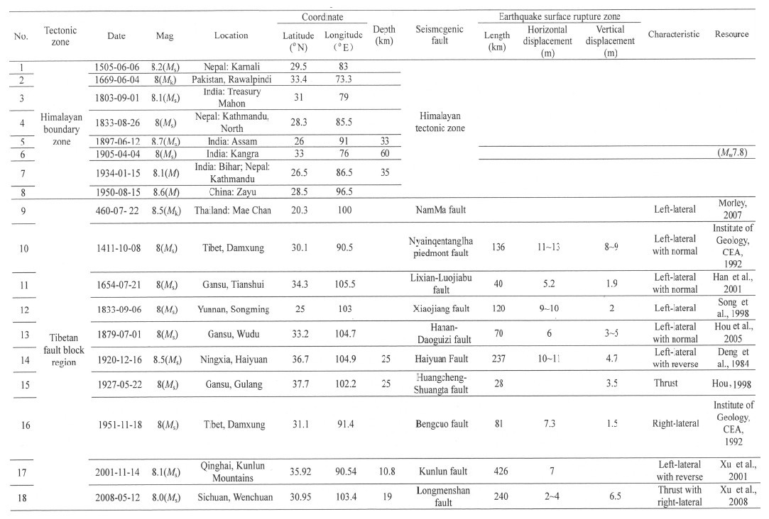
Ever since the recorded history, there have been 18 M ≥ 8.0 and over 100 M7~7.9 earthquakes happenedin Tibetan Plateau, the broad region from the Himalayan plate boundary tectonic zone in the south to HexiCorridor in the northern margin of the plateau(Table 1). The earthquakes over magnitude 8.0 all occurredon the boundary tectonic belts of the Himalayan plate and the Qinghai-Tibet fault block region, as well ason the boundary active tectonic zones of these intra-plate fault blocks(Table 1, Deng et al., 2003a). Of theearthquakes over magnitude 8.0, eight occurred on the Himalayan plate boundary tectonic belt, two on thenorthern boundary tectonic belt of the Qinghai-Tibet fault block region, and four on the eastern boundarytectonic belt. Though earthquakes that occurred in the Himalayan tectonic belt did not show surface rupturezones due to probably the low dip angle of fault plane of seismogenic faults, they are all controlled by activefault zones in the Himalayan tectonic belt. The M8.0 earthquakes that occurred in the intra-plate fault blockregion and on the boundary tectonic zones of the fault sub-blocks are all related to the active faults and activebasins in the boundary tectonic zones.
|
|
Table 1 Earthquakes of M≥8 in the Tibetan Plateau |
The first recorded M7.0 earthquakes in Tibetan Plateau are the northeast Wudu earthquake in 186 B.C., and the Gansu Longxi and west Gaotai earthquakes in 143 A.D. and 180 A.D.. But, in fact, there are fewrecords of M7.0 earthquakes before 1650 A.D.. Most of the M7.0 earthquakes recorded before 1900 occurredin the northern and eastern boundary tectonic zones of the Tibetan Plateau, where the culture was more developed. There are some large earthquakes occurring in the southern margin of Himalayan tectonic belt(Fig. 3a). Therefore, the records of M7.0 earthquakes are uneven in the Tibetan Plateau. In the followinganalysis on the time series distribution of large earthquakes in Tibetan Plateau, earthquakes of magnitude 7.0 and greater after the year of 1900 are selected, for there are instrumental seismic records in the world since then and the records of large earthquake in the plateau are more reliable(Fig. 3b).

|
Fig. 3 MS-T chart of MS ≥ 7 in the Tibetan Plateau (a) From 1600 to 1899; (b) Since 1900. |
Figure 3b shows the time series distribution of seismic activities in the Tibetan Plateau since 1900. As seenin the figure, there have been three climaxes of seismic activities in about 100 years since 1900, and between theclimaxes are the periods of relatively weak seismicity of M7.0 earthquakes of different length of time. The threeclustering periods of M7.0 earthquakes are from 1920 to 1937, from 1947 to 1976 and from 1995 until present.These three clusters of M7.0 earthquakes lasted differently, the earthquakes in each cluster were distributedunevenly, and the interval between clusters is not regular, which may result from inhomogeneity of energyaccumulation and release, however, there are multi M ≥ 7.0 earthquakes and one or more mega earthquakes ofM ≥ 8.0 occurring in each of the seismic clustering periods. For instance, in the 1920–1937 cluster period whichlasted for 17 years, there occurred the Haiyuan M8.5 earthquake in 1920 and the Gulang M8.0 earthquake in1927. The large earthquakes in this period mainly concentrated along the northern boundary of the TibetanPlateau, that is, the main active region of this earthquake series is in the northern boundary tectonic belt ofthe Tibetan Plateau(Deng, 2008; Deng et al., 2009). In the large earthquake cluster period of 1947–1976, themajor region of seismicity of M ≥ 7.0 earthquake is located in the southern Tibetan Plateau. And since 1995, the main active area of majority of M7.0 earthquakes in the Tibetan Plateau is the Bayan Har fault block inthe central Tibetan Plateau. We used to term the earthquakes that occurred continuously in a same clusterperiod as an “earthquake series”, and the one or two largest earthquakes of magnitude over 8.0 in the clusterperiod as the core earthquake(s)of the cluster, which is used to name the earthquake series(Deng et al., 2010).Accordingly, the three seismic series mentioned above are called the Haiyuan-Gulang earthquake series, theZayu-Dumxung earthquake series and the Kunlun-Wenchuan earthquake series(Fig. 4).

|
Fig. 4 Distribution of three earthquake series and major earthquakes in the Tibetan Plateau since 1900 |
Although little analysis has been done on the temporal distribution of earthquakes over magnitude 7.0in the Tibetan Plateau before 1900 because of incompleteness of earthquake data, certain clusters of M ≥ 7.0earthquakes seem to have existed in this region before 1900, as seen from Fig. 3a. Among them, the Assam-Wudu earthquake series in 1863 to 1905 and the Songming-Kumaon earthquake series in 1786–1850 are fairlycomplete as a whole.
It is noted that there are M ≥ 8.0 earthquakes occurring in each cluster period on the Himalayan plate tectonicboundary zone in the southern Tibet, such as the Assam M8.7 earthquake in the Assam-Wudu earthquakeseries, the Bihar M8.1 earthquake in the Haiyuan-Gulang earthquake series, and the Zayu earthquakes in theZayu-Damxung earthquake series, etc. In the recent Kunlun-Wenchuan earthquake series, no M8.0 earthquakehas yet occurred on the Himalayan tectonic zone, but a M7.7 earthquake has occurred in the vicinity of Islamabad, Pakistan in its western part. This phenomenon illustrates the plate boundary tectonic zone has a highdegree of seismic activity, and the intraplate earthquake series in the Tibetan Plateau have a close correlationwith the seismicity on the plate boundary tectonic zones.
Among the above-mentioned earthquake series, the Kunlun-Wenchuan earthquake series is the most recentone and it is still going on. So, its development process will have effect on our estimation of earthquake trendin a certain period of time in the future. Therefore, the features of large earthquake activities in this latestearthquake series are discussed exclusively in the following section.
4 BAYAN HAR FAULT BLOCK AND KUNLUN-WENCHUAN EARTHQUAKE SERIESAs described above, Bayan Har fault block is an elongated fault block in the central Tibetan Plateau, and its southern and northern boundary faults are both of strike-slip. Since the Qiangtang-Sichuan-Yunnanfault block moves fastest towards southeast among all fault blocks in the Tibetan fault block region and thefault blocks north of it move southeastward at a successively decreased rate from south to north, the faultsdeveloped along the southern and northern boundaries of these fault blocks are all of left-lateral strike-slip(Fig. 2). The northern boundary fault of Bayan Har fault block is the East Kunlun fault(Fig. 5a), the mainpart of which is divided into 7 segments(Seismological Bureau of Qinghai Province et al., 1999)(The areawest of Bukedaban Peak is an unpopulated zone, so little study has been done there). Primary research showsthe left-lateral motion of Kusaihu segment(SF7)is up to 8~12 mm·a-1, and it slows down to the east; the sliprate of Xiadawu section(SF3)is 5~6.5 mm·a-1. The southern boundary fault of Bayan Har fault block is theXianshuihe-Yushu-MargaiCaka fault zone, which is also a left-lateral strike slip fault with distinct segmentation.The easternmost segment is the Xianshuihe left-lateral strike slip fault, which is further divided into severalsub-segments, among them Luhuo segment has the fastest horizontal slip rate of up to 13~15 mm·a-1(Li et al., 1997). Yushu fault, at the centre of the southern boundary fault of the fault block, is separated by Ganzipull-apart area from Xianshuihe fault on the east and composed of 5 sub-segments, with a left lateral slip rateabove 7 mm·a-1(Zhou et al., 1996). The MargaiCaka fault, a left lateral strike-slip fault on the west, wasstudied partially for it is located in an unpopulated zone. The strike-slip faults on the northern and southernboundaries of the Bayan Har fault block indicate the kinematic characteristics of the block, that is, the faultblock moves in the southeast direction. At the same time, the Longmenshan-Minjiang faults, as the southeast boundary of Bayan Har fault block, became reverse faults and formed the Cenozoic orogenic belt(Fig. 5a). TheHoushan fault, Zhongyang fault, Qianshan fault and front-range buried fault all together constitute the modernactive Longmenshan thrust zone. The latest activities have migrated northwards from the central and southernsegments to the Minshan uplift as well as to the Minjiang fault and Huya fault on its sides; as a result, theseismic activities of northeastern segment of Longmenshan fault have weakened remarkably(Deng et al., 1994).For the same reason, the southwest section of Altyn Tagh fault, as the northwestern boundary of Bayan Harfault block, became a left-lateral strike-slip fault with extensional component(Fig. 5a). The southwestern endof Altyn Tagh fault is a shear extension of this large scale left-lateral strike-slip fault zone, and the associatedsub-faults are normal faults with left-lateral strike-slip extensional faulting, forming several broom-like faultzones. The extensional component of the southwestern segment of left-lateral strike-slip Altyn Tagh fault zoneis typically manifested by the southeastward movement of Bayan Har fault block(Fig. 5a).

|
Fig. 5 The characteristics of kinetics (a) and focal mechanism (b) of the Bayan Har fault-block and its boundary faults |
Earthquakes occurring around the Bayan Har fault block have varied types, which are compatible with thestructural and kinematic characteristics of the block. Focal mechanisms have indicated that earthquakes alongthe northern and southern boundaries of the block are all of strike-slip type, for example, the Mani earthquake(1997, MS7.5, on the west segment of southern boundary fault), the Yushu earthquake(2010, MS8.1, on thecentral segment of southern boundary fault) and the Kunlunshan earthquake(2001, MS8.1, on the northernboundary fault), and all have produced shear coseismic surface rupture zones, with lengths of 130 km, 61 km and 426 km and horizontal displacements of 3~4 m, 2 m and 7 m, respectively(Figs. 6a, 6b). Earthquakes, such as the Wenchuan earthquake(2008, Ms8.0) and the Lushan earthquake(2013, MS7.0)on the easternboundary faults of Bayan Har fault block are all of thrust type. The Wenchuan earthquake has produced raredouble-faulting coseismic surface rupture zones with the length of 240 km and 70 km for each. The coseismicrupture of the Qianshan fault in Wenchuan earthquake is of thrust with right-lateral component, the coseismicvertical displacement is 6.2 m; the Qianshan fault is a pure overthrust, with a vertical displacement 3.5 m(Figs. 7a, 7b). On the contrast, faults on the northwest boundary of Bayan Har fault block are strike-slipnormal faults or normal strike-slip faults. The Yutian M7.3 earthquake in 2008 occurred on a branch fault ofa broom-like structure zone, its seismogenic fault is a normal fault with strike-slip component, the coseismicvertical displacement of the fault is 3.1 m, and the left-lateral displacement is 1.8 m, indicating a larger verticalcomponent than the horizontal(Fig. 7c). The recent Yutian M7.3 earthquake in April, 2014 occurred on thesouthwest end of Altyn Tagn fault, its seismogenic structure exhibits more prominent strike-slip feature, with thestrike-slip component larger than the vertical. According to the recent study by Li Haibin et al., the coseismicleft-lateral displacement is 1 m, and the vertical displacement is around 0.4 m(Fig. 7d).

|
Fig. 6 Surface ruptures of strike-slip faults at the north and south boundaries of the Bayan Har fault-block (a) The 2001 Kunlunshan earthquake (Xu et al., 2001); (b) The 2010 Yushu earthquake (Sun et al., 2010). |

|
Fig. 7 The coseismic surface rupture zones of Wenchuan earthquake and Yutian earthquakes in 2008 and in 2014 (a) Strike-slip reverse fault and striae of central fault in the 2008 Wenchuan earthquake; (b) The scarp of overthrust fault on the Qianshan fault in the 2008 Wenchuan earthquake; (c) The coseismic surface rupture zone of strike-slip normal fault in 2008 Yutian earthquake (Xu et al., 2011); (d) The coseismic surface rupture zone in 2014 Yutian earthquake, which produced 1 m sinistral displacement and 0.4 m vertical displacement (photograph courtesy of Li Haibing). |
In order to better underst and the seismic dynamic background of Bayan Har fault block, Tibetan Plateau and their status in global seismic activities, we further studied the spatial and temporal distribution characteristicsof global earthquakes with magnitude 8 and above since 1900, and compared them with the seismicityin Tibetan Plateau and Baryan Har fault block, and on this basis, analyzed the relationship of their dynamicbackgrounds.
It’s shown that the global seismicity of M ≥ 8 earthquakes have a close relation with global plate tectonics, which are mainly distributed around plate boundaries of the Pacific ocean and Mediterranean-Himalayan tectonic and seismic zone, although a small amount of earthquakes have happened in intra-continents, e.g. the 1957Gobi-Altai M8.1 earthquake and the 1905 Bulnai M8.4 earthquake in Mongolia. Spatially, great earthquakesare closely correlated with plate tectonics and they are the inevitable result of plate motion. As seen in Fig. 8, the temporal distribution of great earthquakes is uneven, there are two clustering periods of mega-earthquakes, i.e. 1950–1965 and 2001-to the present, which are characterized by high magnitude and frequency, and energyreleasing continuously in a short time. Moreover, there is significant correlation and synchronism of seismicactivities among different plate-margin tectonic zones, plate boundary tectonic zones and in intra-continent.
As indicated in Fig. 8, there was an intensive release of seismic energy in global plate boundary zones in1950–1960s, 2.5×10¹⁹ J in total of strain released, with the annual strain release rate reaching 1.6×10¹⁸ J/a. Atotal of 13 earthquakes with magnitude 8.0 or greater happened, including the 1906 Chile Mw9.6 earthquake, the Alaska Mw9.2 earthquake in 1964 and the 1952 Mw9.0 earthquake in Kamchatka peninsula. These threemega-earthquakes all occurred on the circum-Pacific seismic belt, and one of them, the Chile earthquake, is thelargest magnitude earthquake in historical earthquake records in the world, with the source fault up to 1000 kmin length. The Alaska earthquake is the second largest earthquake in the world, with the source fault of 800 kmin length, a surface rupture of 57 km and a reverse-faulting vertical displacement 6~7 m. Fig. 9 illustrates thecoseismic surface ruptures and fault in 1964 Alaska earthquake. The Hanning Bay fault was activated when theearthquake happened, producing a 3~4.5 m high bedrock scarp. At the Government Hill School in Anchorage, a reverse fault scarp was formed and the teaching building of the school was dislocated by the great earthquake, with a vertical displacement estimated to be 4 m.

|
Fig. 8 Worldwide spatial and temporal distribution of seismic epicenters of Mw ≥ 8.0 since 1900 (a) Spatial distribution of seismic epicenters. Pentagrams represent earthquakes of Mw ≥ 9.0; dots indicate earthquakes of Mw ≥ 8.0 ~ 8.9, the red ones show earthquakes in 2001–2014, the yellow ones show earthquakes in 1950–1965, the green dots show earthquakes in other times; (b) The global chart of Mw-T of Mw ≥ 8.0 since 1900, the red dots show earthquakes of Mw ≥ 9.0 in 2001–2014, the blue dots show Mw ≥ 9.0 in 1950–1965; the “(2)” shows two earthquakes with same magnitude in one year. |

|
Fig. 9 Surface displacement of the 1964 9.2 great Alaska earthquake (cited from USGS) (a) Hanning Bay fault was activated and formed the bedrock scarp when the earthquake happened; (b) Teaching building of Government Hill School in Anchorage was dislocation and a fault scarp was formed by the great earthquake. |
Another worldwide seismic climax of Mw ≥8.0 earthquake has developed since 2001(Fig. 8). Till 2012, 15earthquakes with magnitude Mw=8.0 or greater have occurred, with 9.5×10¹⁸J of strain released in total and astrain release rate of 7.9×10¹⁷ J/a. Recently, there occurred the Sea of Okhotsk deep earthquake with magnitudeof Mw8.3 and Soloman M8.0 earthquake in 2013, and the Chile Mw8.2 earthquake in 2014 respectively, whichsuggest clearly that this seismic climax is still ongoing. The 2011 Japan Mw9.1 earthquake and 2004 SumatraMw9.0 earthquake are considered as the core earthquakes in this seismic climax period, the former happenedat the Japan subduction zone on the west Pacific seismic belt, which caused about 600 km-long source fault, asrevealed by aftershocks; the latter occurred at Sumatra subduction zone of Mediterranean-Himalayan seismicbelt and caused a 1200 km long source fault, as shown by aftershocks. Using the GPS data provided byGan Weijun, we found that the 2011 off the Pacific coast of Tohoku earthquake directly affected the coseismichorizontal displacement distribution of northeastern China, Korean peninsula and southeastern Russia(Fig. 10).

|
Fig. 10 Distribution of coseismic horizonal displacement of GPS of Mw9.1 near the east coast of Honshu, Japan in 2011 (provided by Gan Weijun) |
Comparing the above-discussed active tectonics of Tibetan Plateau with the seismicity characteristics ofthe globe, the Tibetan Plateau and the Bayan Har fault block, we can reach the following conclusions: First, global plate tectonic activities are correlated closely with Tibetan Plateau, the deformation, movement and seismic activities of Tibetan Plateau are closely related to global plate motion and dynamics; and second, thehistorical and current seismic clusters and climaxes in Bayan Har fault block and Tibetan Plateau have a oneto-one correspondence to the clusters of mega-earthquakes all over the world, which fully shows the correlationbetween the regional and global dynamic system.
Figure 11 represents the comparison of seismicity evolutions in different tectonic zones with the currentseismic active cluster among Sumatra, Tibetan Plateau and Bayan Har fault block, which indicates that theseregions have entered successively into a new seismic cluster period since about 2001, and this period is still goingon up till now. Since 2010, earthquakes have occurred continuously on all of the active tectonic zones of variouslevels or tectonic regions, and this process is continuing today. For instance, in a global scope, there are the ChileMw8.8 earthquake in 2010, the Japan Mw9.1 earthquake in 2011, the Sumatra Mw8.6 and Mw8.3 earthquakesin 2012, the Sea of Okhotsk Mw8.3 and Solomon Isl and s Mw8.0 earthquakes in 2013, and the April 2014, Mw8.2 Chile earthquake. In Tibetan Plateau and Bayan Har fault block, several earthquakes occurred successively inthe recent years, including the 2010 Yushu earthquakes(MS7.1, MS6.9), the 2012 Yutian earthquake(MS6.2), the 2013 Lushan earthquakes(MS7.0, Mw6.6) and the 2014 Yutian earthquakes(MS7.3, Mw6.9), etc. In thisnew seismic cluster period, we haven’t seen any signs about cease of seismic activity. On the other h and , thestrain release, strain release rate, energy amount and magnitude of the present seismic cluster period are alllower than that of the former ones, which suggests the current seismic climax has not been over yet, and weestimate it will last for years based on the results we obtained in tracking the progress of earthquakes of allmagnitude levels. Besides, the magnitude of the core earthquake(s)in global seismic cluster is always at 8~9, and the core earthquake’s in Tibet and Bayan Har fault block is around 7~8, all of which mean that global plateboundary zones and Tibetan Plateau and Bayan Har fault block are at risk of being hit again by magnitude8~9 or magnitude 7~8 earthquakes, respectively during the remaining period of this seismic climax. As wepredicted many times in the recent years, a magnitude=7.3 earthquake hit Yutian again in February 2014 inBayan Har fault block, and a massive magnitude=8.2 earthquake also occurred in Chile on the East PacificOcean plate boundary.

|
Fig. 11 Comparison diagram of earthquakes Mw-T among Sumatra, the Tibetan Plateau and Bayan Har fault-block |
It is worth noting that, since 2001, earthquakes of magnitude ≥7.0 in the continent of China are allconcentrated in Bayan Har fault block in the central Tibetan Plateau, and magnitude=6 earthquakes occurredonly at Tibet and Xinjiang tectonic zones, except for the magnitude 7.0 earthquakes in Taiwan and deep earth quake in Northeast China. For seismicity in Tibetan Plateau, the Bayan Har fault block is the major seismicactive region of the Kunlun-Wenchuan earthquake series. M ≥ 6 earthquakes concentrate mostly in the BayanHar fault block and the southern north-south seismic zone at the south of the block, though a few have happenedin the northern Tibet(Fig. 12). According to the analysis of seismic situation of China in the last two years(Liu, 2013), Tibetan Plateau is the seismically most active region, while the seismicity in Tianshan region hasdecreased relatively; small earthquakes and small earthquake swarms appeared at northeastern China, and theseismicity is quiet and stable in South and North China. This whole seismic situation is also compatible withthe general seismic trend since 2001. Seismic activity is very complex, however, the activity features in a certainrange of space-time can be referenced.

|
Fig. 12 Distribution of seismic epicenters of MS ≥6.0 since 2001 |
To sum up, we draw the following conclusions about the current seismic activities in Tibetan Plateau and even in the mainl and of China based on the above data and its analysis:
(1)The Kunlun-Wenchuan earthquake series taking place at central Tibetan Plateau since 1997 is themost important and the only seismic cluster of magnitude≥7.0 in Chinese mainl and in the past more than ten years, which is the result of movement of the Bayan Har fault block. This earthquakes series occurred in themain active region of M7 earthquakes in Tibetan Plateau and even in whole China, and also is one of the threeseismic climaxes in Tibetan Plateau since 1900, and meanwhile it coincides with the climax episode of megaearthquakeactivity in the world since 2001 as well. Even now, both the global seismic climax and the climaxin Bayan Har fault block are continuing, without signs yet indicating the cease of the process of continuousoccurrence of earthquakes, the duration of this seismic climax seems shorter than the former ones, the energyrelease and the magnitude of the biggest earthquake or core earthquake also lower than the former. Overall, the global seismic climax since 2001 and the Kunlun-Wenchuan seismic series since 1997 are both not over yet, and they may last for a certain period of time.
(2)M ≥ 6.0 earthquakes mostly occurred in Tibetan Plateau, especially in Bayan Har fault block of thecentral Tibet, and at the southern Tibetan Plateau and the mid-south segment of the north-south seismic zone.Seismic activity in eastern China is quiet, and only some small earthquakes and swarms with magnitude 5.8occurred in northeastern China tectonic region. In general, there’s no clear sign of large earthquakes migratingfrom the above-mentioned current main seismic active region. Considering that the maximum magnitude ofearthquake is around M8.0~9.0 in a global seismic climax period and M7.0~8.0 in the Tibet fault block region and Bayan Har fault block, we can take these as the estimates of the future earthquake magnitudes in a certainperiod of time. Therefore, during the forthcoming couple of years in the remaining period of the current seismicclimax, we should pay more attention to the potential of generating magnitude 7.0 earthquakes in TibetanPlateau, especially in Bayan Har fault block, southern part of Tibetan Plateau and mid-south segment ofnorth-south seismic zone.
(3)On the basis of above analysis, we make the following suggestions: ① To further strengthen the seismic hazard study of the seismic quiescence segments and the areas with longer elapsing time from earthquakes;relevant intensive study shall be initiated in the central and eastern parts of Bayan Har fault block and themid-south of the north-south seismic zone, except unpopulated areas, to explore the active tectonic and seismicrisk segments that may have potential for big earthquake; ② To strengthen seismicity analysis and study, payattention to whole seismicity pattern, the seismicity level and its migration, and endeavor to catch foreshocks.③ On the basis of intensive studies on active tectonics, seismogenic faults and seismicity, the seismic precursorobservation networks in the above-mentioned areas shall be supplemented and optimized; Mass prediction and disaster prevention of earthquakes, uniform arrangement and combined observation shall be further promotedso as to gain deeper insights into the changes of precursory field and improve the short-term and imminentearthquake prediction. ④ On the basis of intensive observation, keep a watchful eye on possible migration of themain seismic active region to other place in order to prepare against the unexpected events and the associatedsudden disasters.
This work was supported by the National Key Technology Research project “Wenchuan Earthquake ScientificDrilling Project” and Administrative project of Ministry of Finance “Hazard assessment of active faultson key areas under surveillance for and protection against earthquakes”.
| [1] | Armijo R, Tapponnier P, Merecier J L, et al. 1986. Quaternary extension in southern Tibet:field observations and tectonic implications. Journal of Geophysical Research, 91(B14):13803-13872. |
| [2] | Armijo R, Tapponnier P, Han T. 1989. Late Cenozoic right-lateral strike-slip faulting in southern Tibet. Journal of Geophysical Research, 94(B3):2787-2838. |
| [3] | Burchfiel B C, Royden L H. 1985. North-south extension within the Convergent Himalayan region. Geology, 13(10):629-682. |
| [4] | Burchfiel B C, Chen Z, Hodges K V, et al. 1992. The South Tibet detachment system, Himalayan orogen:extension contemporaneous with and parallel to shortening in a collisional mountain belt. Geological Society of America Special Paper, 269:1-41. |
| [5] | Burtman V S, Molnar P. 1993. Geological and geophysical evidence for deep subduction of continental crust beneath the Pamir. Geological Society of America Special Paper, 281:1-76. |
| [6] | Coward M P, Butler R W H. 1985. Thrust tectonics and the deep structure of the Pakistan Himalaya. Geology, 13(6):417-420. |
| [7] | Deng Q D. 1984. Kinematic features and slip rates of late Quaternary active faulting of Qinghai-Xizang (Tibet) Plateau and kinematic characteristics of the plateau and secondary blocks within it (in Chinese). Himalayan Geology International Symposium Abstracts. Chengdu, China. 70-72. |
| [8] | Deng Q D, Chen S F, Zhao X L, et al. 1994. Tectonics, seismicity and dynamics of Longmenshan Mountains and its adjacent regions. Seismology and Geology (in Chinese), 16(4):389-403. |
| [9] | Deng Q D, Zhang P Z, Ran Y K, et al. 2003a. Basic characteristics of active tectonics of China. Science in China (Series D), 46(4):356-372. |
| [10] | Deng Q D, Zhang P Z, Ran R K, et al. 2003b. Active tectonics and earthquake activities in China. Earth Science Frontiers(in Chinese), 10(Suppl.):66-73. |
| [11] | Dene Q D. 2008. Some thoughts on the Ms8.0 Wenchuan, Sichuan earthquake. Seismology and Geology (in Chinese), 30(4):811-827. |
| [12] | Deng Q D, Gao X, Yang H. 2009. Fault-block tectonics, active fault-block tectonics and earthquake activity. Chinese Journal of Geology (in Chinese), 44(4):1083-1093. |
| [13] | Deng Q D, Gao X, Chen G H, et al. 2010. Recent tectonic activity of Bayankala fault-block and the Kunlun-Wenchuan earthquake series of the Tibetan Plateau. Earth Science Frontiers (in Chinese), 17(5):163-178. |
| [14] | Deng Q D. 2012. A new upsurge in global seismicity. Seismology and Geology (in Chinese), 34(4):545-550. |
| [15] | Fan G W, James F N, Wallace T C. 1994. Active tectonics of the Pamirs and Karakorum. Journal of Geophysical Research, 99(B4):7131-7160. |
| [16] | Feng X Y. 1994. Surface rupture associated with the 1985 Wuqia earthquake in Xinjiang. Research on Active Fault, (3)(in Chinese). Beijing:Seismological Press, 45-55. |
| [17] | Gao X, Deng Q D. 2013. Activity analysis of large earthquakes in boundary faults around the Bayankala faulting block.Acta Geologica Sinica (in Chinese), 87(1):9-19. |
| [18] | Guo S M, Ji F J, Xiang H F, et al. 2001. The Honghe Active Fault Zone (in Chinese). Beijing:Ocean Press, 1-172. |
| [19] | Han Z J, Xiang H F, Ran Y K. 2001. Activity analysis of Lixian-Luojiapu fault zone in the east boundary of Tibetan Plateau since the Late Pleistocene. Seismology and Geology (in Chinese), 23(1):43-48. |
| [20] | Hodges K V. 2000. Tectonics of the Himalaya and southern Tibet from two perspectives. Geological Society of America Bulletin, 112(3):324-350. |
| [21] | Hou K M. 1998. Characteristics of ground ruptures caused by 1927 Gulang M8 earthquake and their causative mechanisms.Seismology and Geology (in Chinese), 20(1):19-26. |
| [22] | Hou K M, Lei Z S, Wan F L, et al. 2005. Research on the 1879 Southern Wudu M8.0 earthquake and its coseismic ruptures. Earthquake Research in China (in Chinese), 21(3):295-310. |
| [23] | Institute of Geology, CEA, Seismological Bureau of Ninxia Hui Autonomous Region. 1990. The Haiyuan Active Fault Zone (in Chinese). Beijing:Seismological Press, 1-286. |
| [24] | Institute of Geology, CEA, Yunnan Seismology Bureau. 1990. The Active Fault Zone in the Northwest of Yunnan Province(in Chinese). Beijing:Seismological Press, 1-319. |
| [25] | Institute of Geology, CEA. 1992. Active Faults in the Central Tibet (in Chinese). Beijing:Seismological Press, 1-229. |
| [26] | Institute of Geology, CEA, Lanzhou Institute of Seismology, CEA. 1993. Qilian Mountain-Hexi Corridor Active Fault System (in Chinese). Beijing:Seismological Press, 1-340. |
| [27] | Lanzhou Institute of Seismology, CEA. 1992. Changma Active Fault Zone (in Chinese). Beijing:Seismological Press, 1-207. |
| [28] | Lavé J, Avouac J P. 2000. Active folding of fluvial terraces across the Siwaliks Hills, Himalayas of central Nepal. Journal of Geophysical Research, 105(B3):5735-5770. |
| [29] | Li T S, Du Q F, You Z L, et al. 1997. The Xianshuihe Active Fault and Seismic Hazard Assessment (in Chinese).Chengdu:Chengdu Maps Publishing House, 1-230. |
| [30] | Li W Q, Chen J, Yuan Z D, et al. 2011. Coseismic surface rupture of multi segments and seismogenic fault of the Tashkorgan earthquake in Pamir, 1895. Seismology and Geology (in Chinese), 33(2):260-276. |
| [31] | Liu J, Yi G X, Zhang Z W, et al. 2013. Introduction to the Lushan, Sichuan M7.0 earthquake on 20 April 2013. Chinese J. Geophys. (in Chinese), 56(4):1404-1407. |
| [32] | McCaffrey R, Nabelek J. 1998. Role of oblique convergence in the active deformation of the Himalayas and southern Tibet plateau. Geology, 26:691-694. |
| [33] | Molnar P, Tapponnier P. 1975. Cenozoic tectonics of Asia:effects of a continental collision. Science, 189(4201):419-426. |
| [34] | Morley C K. 2007. Variations in late Cenozoic-Recent strike-slip and oblique-extensional geometries, within Indochina:The influence of pre-existing fabrics. Journal of Structural Geology, 29(1):36-58. |
| [35] | Nakata T. 1989. Active faults of the Himalaya of India and Nepal. Spec. Pap. Geol. Soc. Am., 232:243-264. |
| [36] | Research Group of the Active Altyn Fault Zone, State Seismology Bureau. 1992. The Active Altyn Fault Zone (in Chinese). Beijing:Seismological Press, 1-319. |
| [37] | Seismological Bureau of Qinghai Province, The Institute of Crustal Dynamics, CEA. 1999. The East Kunlun Active Fault Zone (in Chinese). Beijing:Seismological Press, 1-186. |
| [38] | Song F M, Wang Y P, Yu W X, et al. 1998. The Active Xiaojiang Fault Zone (in Chinese). Beijing:Seismological Press, 1-237. |
| [39] | Sun X Z, Xu X W, Chen L C. 2010. Characteristics of surface rupture of the Ms7.1 Yushu, Qinghai province earthquake at two representative places. Seismology and Geology (in Chinese), 32(2):338-344. |
| [40] | Tang R C, Han W B. 1993. Active Fault and Earthquake in Sichuan Province (in Chinese). Beijing:Seismological Press, 1-368. |
| [41] | Tapponnier P, Molnar P. 1977. Active faulting and tectonics in China. Journal of Geophysical Research, 82(20):2905-2930. |
| [42] | Wang Q, Zhang P Z, Freymueller J T, et al. 2002. Present-day crustal movement and tectonic deformation in continental China. Science in China, Series D, 45(10):865-874. |
| [43] | Wang Q L. 2009. The Third Chapter of Wenchuan 8.0 Earthquake Scientific Research Report:The Research of the Vertical Deformation Field in Wenchuan Ms8.0 Earthquake (in Chinese). Beijing:Seismological Press. |
| [44] | Xu X W, Chen W B, Yu G H, et al. 2001. Characteristic features of the surface ruptures of the Hou Sai Hu (Kunlunshan) earthquake (Ms8.1), northern Tibetan plateau, China. Seismology and Geology (in Chinese), 24(1):1-13. |
| [45] | Xu X W, Wen X Z, Ye J Q, et al. 2008. The Ms8.0 Wenchuan earthquake surface ruptures and its seismogenic structure.Seismology and Geology (in Chinese), 30(3):597-629. |
| [46] | Xu X W, Tan X B, Wu G D. 2011. Surface rupture features of the 2008 Yutian Ms7.3 earthquake and its tectonic nature.Seismology and Geology (in Chinese), 33(2):462-471. |
| [47] | Yin A. 2001. Geologic evolution of the Himalayan-Tibetan orogen in the context of phanerozoic continental growth of Asia. Acta Geoscientia Sinica (in Chinese), 22(3):193-230. |
| [48] | Yin A. 2006. Cenozoic tectonic evolution of the Himalayan orogen as constrained by along-strike variation of structural geometry, exhumation history, and foreland sedimentation. Earth Science Frontiers (in Chinese), 13(5):416-515. |
| [49] | Zhang Y M, Li M F, Meng Y Q, et al. 1996. Research on fault activities and their seismogeological implication in Bayankala mountain area. Research on Active Fault (in Chinese), (5):154-171. |
| [50] | Zhang P Z,Wang Q, Ma Z J, et al. 2002. GPS velocity field and active crustal blocks of contemporary tectonic deformation in continental China. Earth Science Frontiers (in Chinese), 9(2):430-441. |
| [51] | Zhou R J, Ma S H, Cai C X. 1996. Late quaternary active features of the Ganzi-Yushu fault zone. Earthquake Research in China (in Chinese), 12(3):250-260. |