2. Institute of Geomechanics, Chinese Academy of Geological Sciences, Beijing 100081, China;
3. CNOOC Zhanjiang Branch, Zhanjiang, Guangdong 524057, China
Many oceanic engineering projects are planned or have been put into effect in the Northern South China Sea, which has become an important base for ocean oil and gas production. The status and distribution of present crustal stresses in the Northern South China Sea is not well understood because its physical environmental conditions do not facilitate research and measurements, which in turn has impeded the progress of oceanic engineering projects. Crustal stress directly influences geological processes and earthquakes, which is the inherent driving force of geological hazards and an important force influencing oil and gas migration(Sibson, 1994; Rouchet, 1981; Wu et al., 1999). Although landforms, crustal structure, and geological features are important controlling factors of crustal stress, plate tectonic influences are dominant(Lithgow-Bertelloni and Guynn, 2004; Zoback, 1992; Fan et al., 2012). The South China Sea is the largest marginal sea in the Western Pacific Ocean, and was formed as a result of complex interactions of the Eurasia, Pacific, and India-Australia plates. The continental margins around the South China Sea are of three different types: passive extensional margins in the north and south; an active subduction margin to the east; and a shearing transform margin in the west(Luan and Zhang, 2009).
To date, the primary methods for obtaining the status of crustal stress include in situ stress measurements, focal mechanisms, well bore analysis, and numerical modeling and so forth. Due to the restrictions of geological conditions and measurement technology, the measured crustal stresses from different methods can show the stress status at different depths. For instance, information can be obtained for shallower depths with in situ measurements and well bore analysis, and at greater depths using focal mechanisms. However, these data can be integrated to the regional stress and can show the regional tectonic stress status(Zoback, 1992, Xie et al., 2004).
The in situ measurement method is a valid way of obtaining stress status including absolute magnitude and direction. This method has been used in engineering design and safety evaluation(Meng et al., 2012) and is an important component of regional stress research(Zoback and Healy, 1992; Chen et al., 2002; Wu et al., 2005, 2008). During well drilling, breakout or induced extensive fracture can occur when the pressure induced by the drilling fluid is less or more than the stress status of wellbore, which is generated by the regional tectonic stress. The tectonic stress characters can be obtained from wellbore analyses through well logging and the collection of data such as well diameter and Formation Microscanner Images(FMI). Furthermore, numerical modeling can acceptably extrapolate the stress field using the constraints of the limited measured data and geological environment(Fan et al., 2012; Zhu and Shi, 2006).
Many geologists have conducted preliminary analyses of the crustal stress in the South China Sea(Liu, 1993; Qiu and Liu, 1989; Wang 2012). However, the stress status, distribution pattern and controlling factors remain unclear. New technologies have been used for oil and gas exploration and the development of the Northern South China Sea, which provide new data for crustal stress analysis. In this study, the authors comprehensively examine the northern South China Sea’s stress status, distribution character, and controlling factors using in-situ stress measurements, FMI, and focal mechanism analyses in addition to numerical modeling.
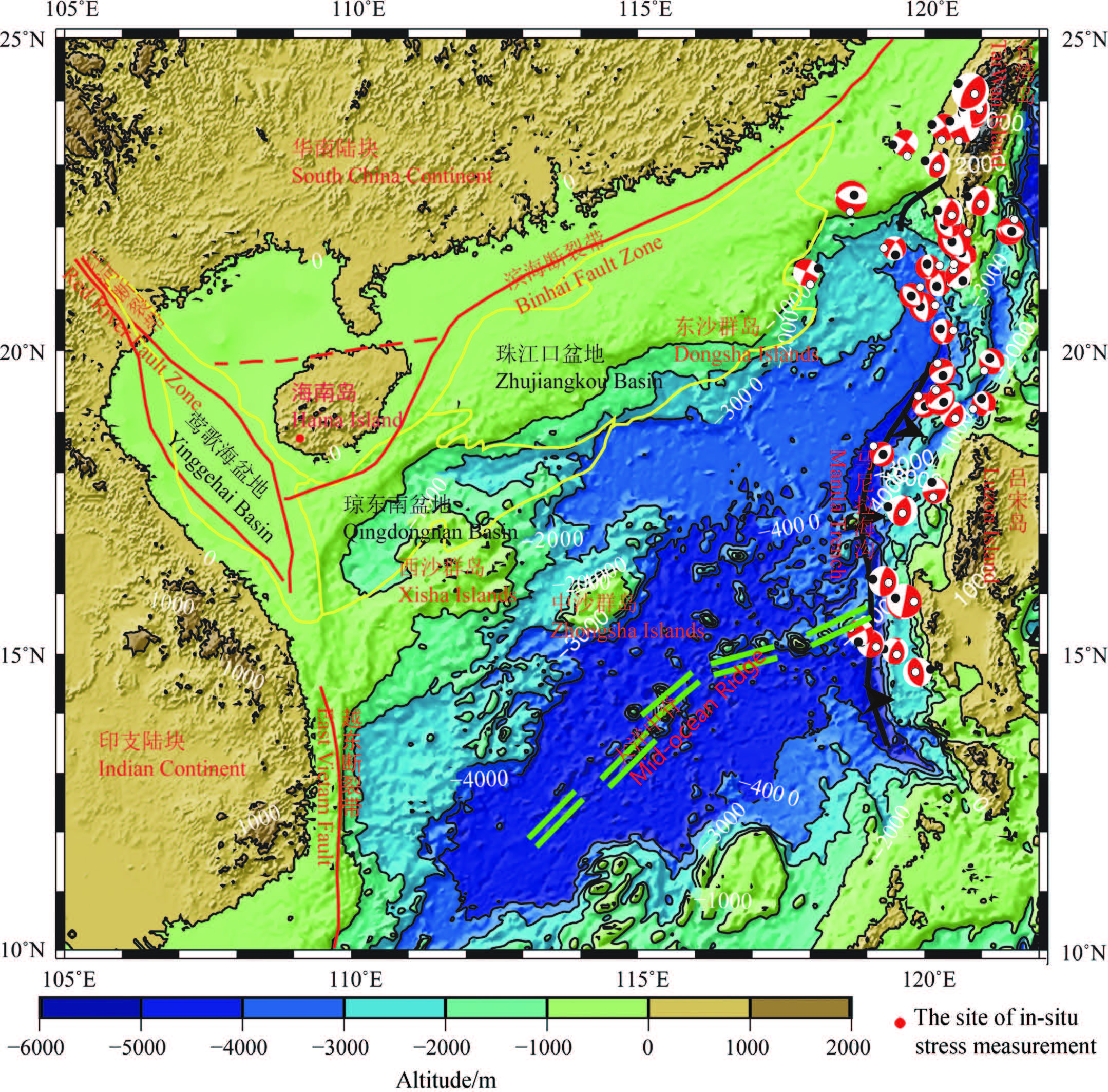
2 TECTONIC SETTINGThe tectonic properties around the northern South China Sea are inconsistent. In the north, there is the NEE-striking Binhai active fault zone(Fig. 1)that separates the normal continent crust of South China from the continent thinning transition crust. This fault bifurcates in the eastern Qiongzhou strait with one branch passing through the Qiongzhou strait to the Beibuwan and the other extending along the eastern coast of Hainan isl and and intersecting the Red River fault near the southern coast of the isl and (Xu et al., 2010). There exists a series of Cenozoic basins, including the Taixinan, Zhujiangkou, and Qiongdongnan basins, where the Cenozoic sedimentation is more than 10000 m thick and the geological structures trend NEE to E-W(Zhou et al., 1995). To the west, the large strike slip Red River-east Vietnam Fault dominates, which is related to the collision of the Indian and Eurasia plates, and the uplift of the Tibetan plateau. This fault divides the South China, northern South China Sea, and Indonesian blocks, whose evolution led to the generation of the South China Sea basin(Tapponnier et al., 1986; Briais et al., 1993; Peltzer and Tapponnier, 1988; Hall et al., 2008; Wang et al., 2000; Lee and Lawver, 1995) and the Yinggehai Basin(Ren and Lei, 2011). Furthermore, along the fault, there are a series of cascade shear-normal marginal faults(Yao et al., 1999; Lin et al., 2009).
|
Fig.1
Tectonic setting of the northern South China Sea Reference Xu et al.(2010), Briais et al.(1993), Yao et al.(1999), and Lin et al.(2009). |
Seafloor extension in the South China Sea is generally accepted, although its mechanism is not completely understood. However, all possible explanations have noted the E-W magnetic anomaly belts within the seafloor(Luan and Zhang, 2009; Liu et al., 1993). Although these magnetic anomaly belts show the seafloor to have ceased extendion around 15.5 Ma, which is represented by the 5c anomaly(Briais, 1993), GPS analysis suggests that the seafloor is still extending in NS along the ocean ridge(Li et al., 2010).
The eastern boundary of the South China Sea is the Manila trench, which represents the plate boundary between the Eurasia and the Philippine Sea plates. Near Taiwan and Luzon, the isl and arcs collide along the Manila trench(Stephan et al., 1986). The South China Sea plate is subducting beneath the Philippine plate along the Manila trench between Taiwan and Luzon(Bautista et al., 2001; Yang et al., 1996; Pautot and Rangin, 1989). To the east of the Manila trench, there are many reverse faults in the sedimentary basin, whereas there are normal active faults in the sedimentary basin to the west of the trench. Focal mechanisms show that the tectonic crustal stress is compressive to the east, but extensional to the west(Bautista et al., 2001; Ku and Hus, 2009; Hsu et al., 2012). There are convergent boundaries near Taiwan and Luzon isl and s; however, in the Manila trench between Taiwan and Luzon isl and s, the South China Sea plate is subducted beneath the Philippine plate, which is driven by negative buoyancy that results from the greater density of the subducting plate compared to the overlying plate(Turcotte and Schubert, 2002). The continuous subduction of the South China Sea plate has generated an accretionary wedge to the east of the Manila trench and has compacted the Philippine plate, inducing the extension of the South China Sea Plate to the west of Manila trench. The subducting South China Sea plate therefore has different influences on the Philippine plate at different parts of the Manila trench.
3 IN SITU CRUSTAL STRESS MEASUREMENTS ON HAINAN ISLAND 3.1 Geological Outline of Stress Measurement SitesIn situ stress measurement is a valid direct method of obtaining stress magnitude and direction. Hainan Isl and is the main continental l and mass in the northern South China Sea where the geological structures are dominated by the large offshore faults and the Red River fault. The isl and hosts two sedimentary basins: Yinggehai and Qiongdongnan. To investigate the crustal stress in the northern South China Sea the authors drilled one 300-m-deep well and measured crustal stress using hydraulic fracturing. The well’s site is located at Fubao village, Qianjia town, Ledong county, with geographic coordinates of N18°31'22'', E109°06'34''. The rock mass comprises intact gray-white, medium grained granite and granodiorite in which the fracture and weak zones are invisible.
3.2 Hydraulic Fracturing Stress MeasurementHydraulic fracturing stress measurement is a valid method for obtaining stress from the deep wellbore and is one of the main methods recommended by the International Committee on Rock Mechanics Testing Technology(Haimson and Cornet, 2003). It is widely used in the survey and design of large projects such as water conservancy and hydropower engineering, deeply buried tunnels for rail or road, nuclear waste disposal, and petroleum strategic reserve. It is also used in scientific research of geodynamics and earthquake prediction(Li and Liu, 1986; Zoback et al., 1985; Zoback and Healy, 1992).
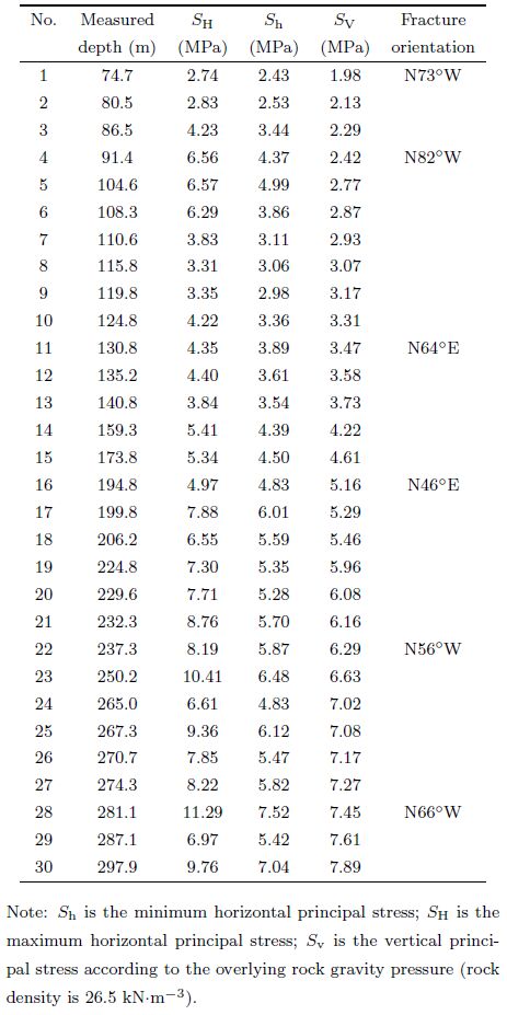
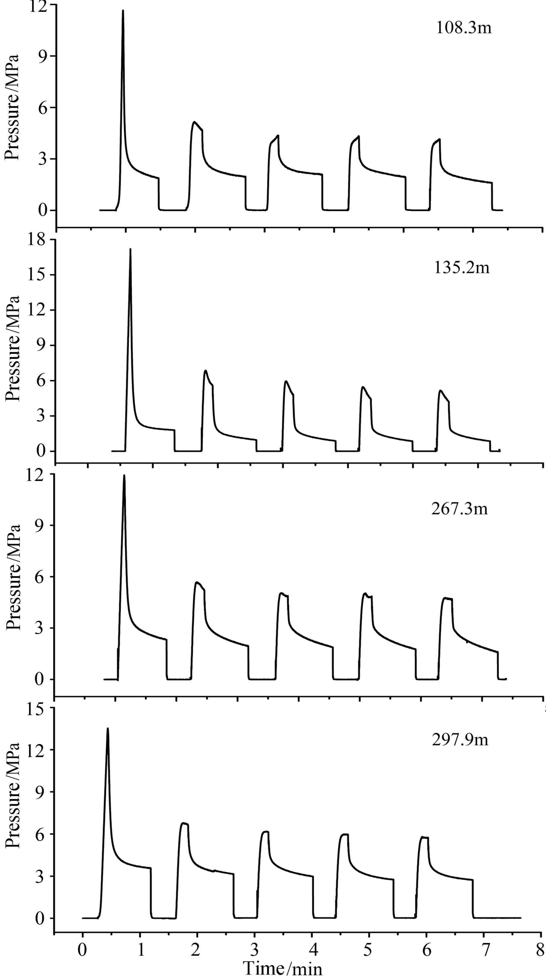
The Rock Quality Designation(RQD)is nearly 100% in the drill well. Hydraulic fracturing was tested in 36 sections, of which in 30 sections the test results were good. The direction of maximum principal stress is determined by impression technology, where the impression result is considered good when the fracture indication is clear and has a symmetrical distribution. The measure curve is fit to a st and ard whose inflection of closed pressure is very distinct(Fig. 2). The stress measurement retests are well repeatable, which indicates that the result is reliable. The results of these stress tests and the directions of maximum principal stresses are listed in Table 1.
|
Fig.2 Hydraulic fracture curves at different depths |
| Table 1 In situ measured stress from Ledong County, Hainan Province |
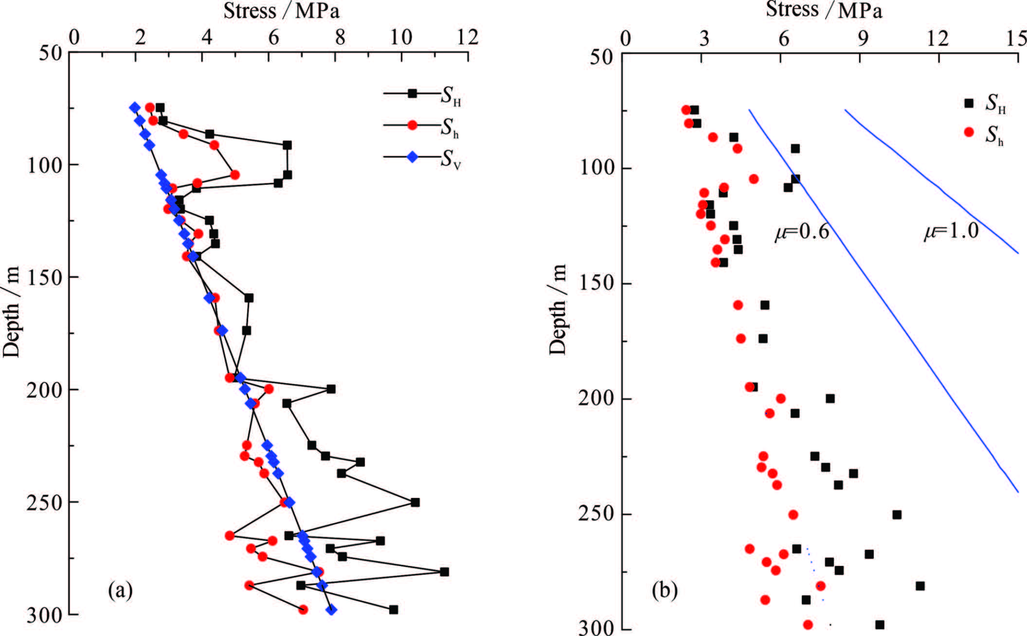
Figure 3 shows the maximum principal stress curve with depth, which indicates that SH > Sh > Sv at depths less than 200 m and SH > Sv > Sh at depths greater than 200 m. The dominant direction of the horizontal maximum principal stress is NWW. The ratio of SH/Sh is 1.03~1.12 at depths between 120 and 200 m. The horizontal and vertical stresses are equivalent. Owing to anisotropic and r and om fracturing, some measured directions of maximum principle stress are dispersed, such as the measured results of N64°E and N46°E, which deviate from the predominant direction of maximum horizontal principal stress of NW-NWW. This dominant direction is consistent with the measured directions of maximum horizontal principal stress, N76°W and N79°W, which were obtained by Wu and Liao(2000)using overcoring of the piezomagnetic stress gauges at the Damao mountain tunnel south of the Jiusuo-Linshui fault.
|
Fig.3 Curve of principal stress(a) and the Byerlee criteria(b)with depth |
The activity on a fault is related to the crustal stress status. According to the Coulomb criteria, if the shear stress τ on the fault plane is greater than the slide resistant force μσn, the fault will reactivate. Here, μ is the coefficient of friction on the fault determined by testing, and σn is the normal stress on the fault plane. This can be illustrated by the principal stress, and considering effective stress as follows:

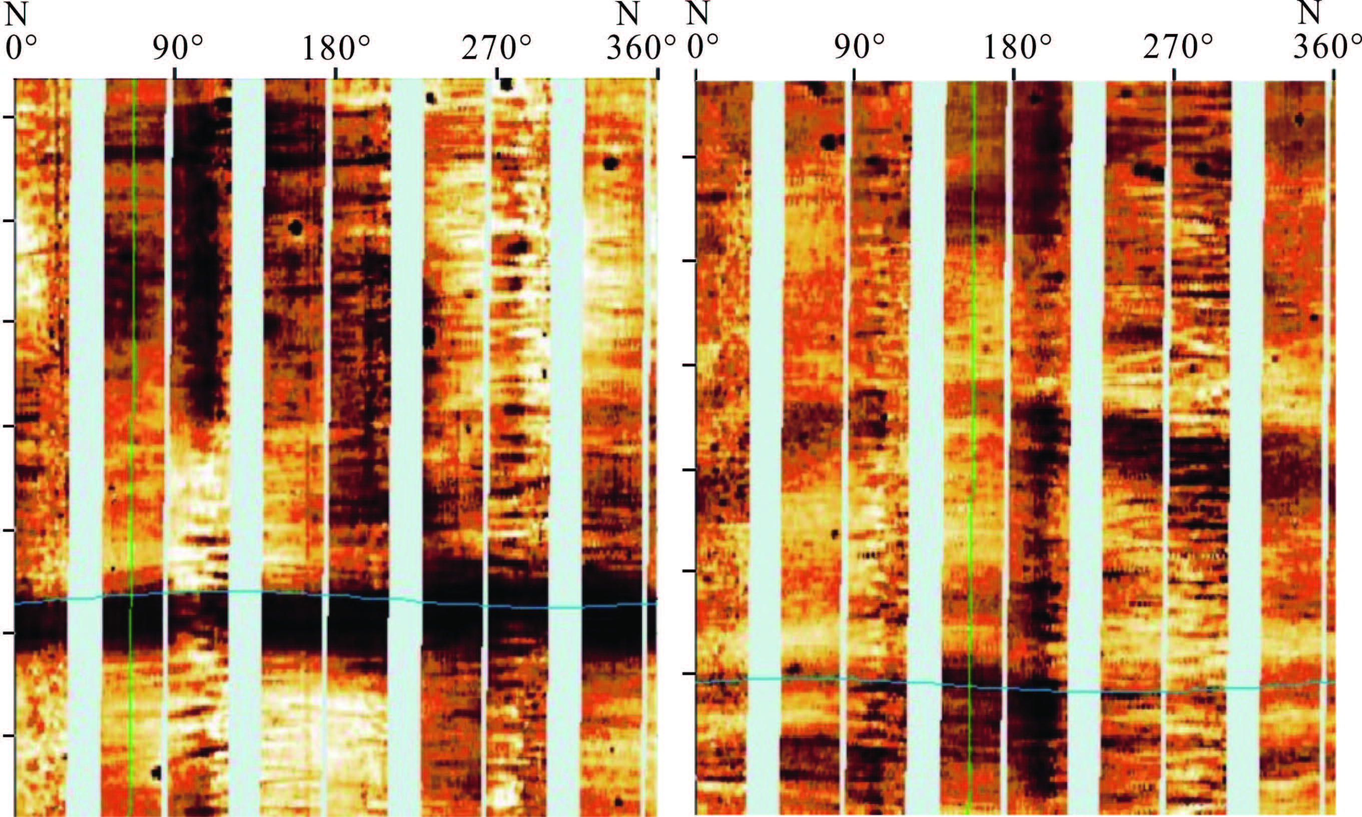
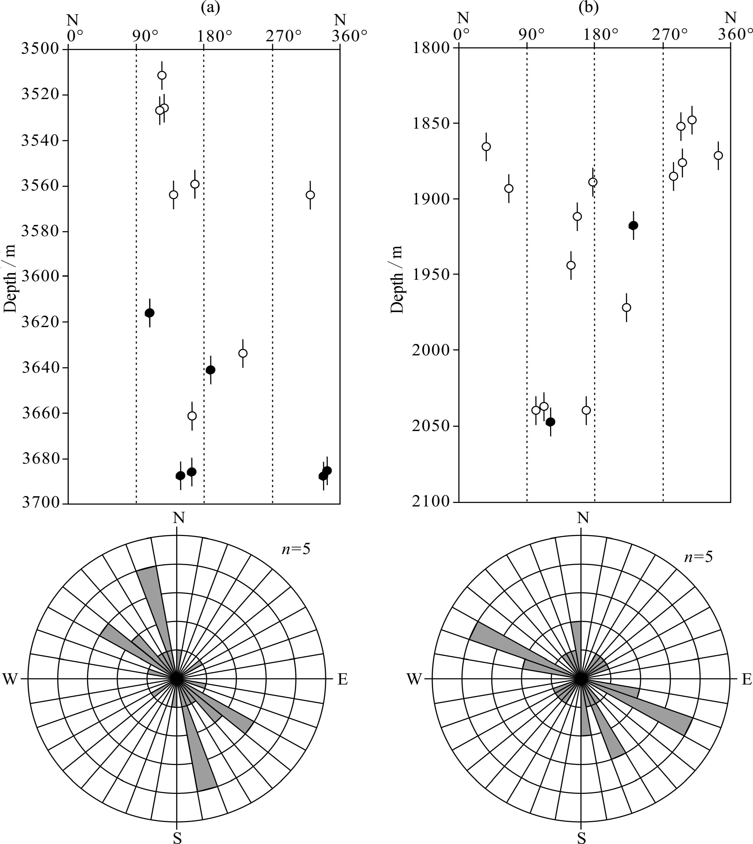
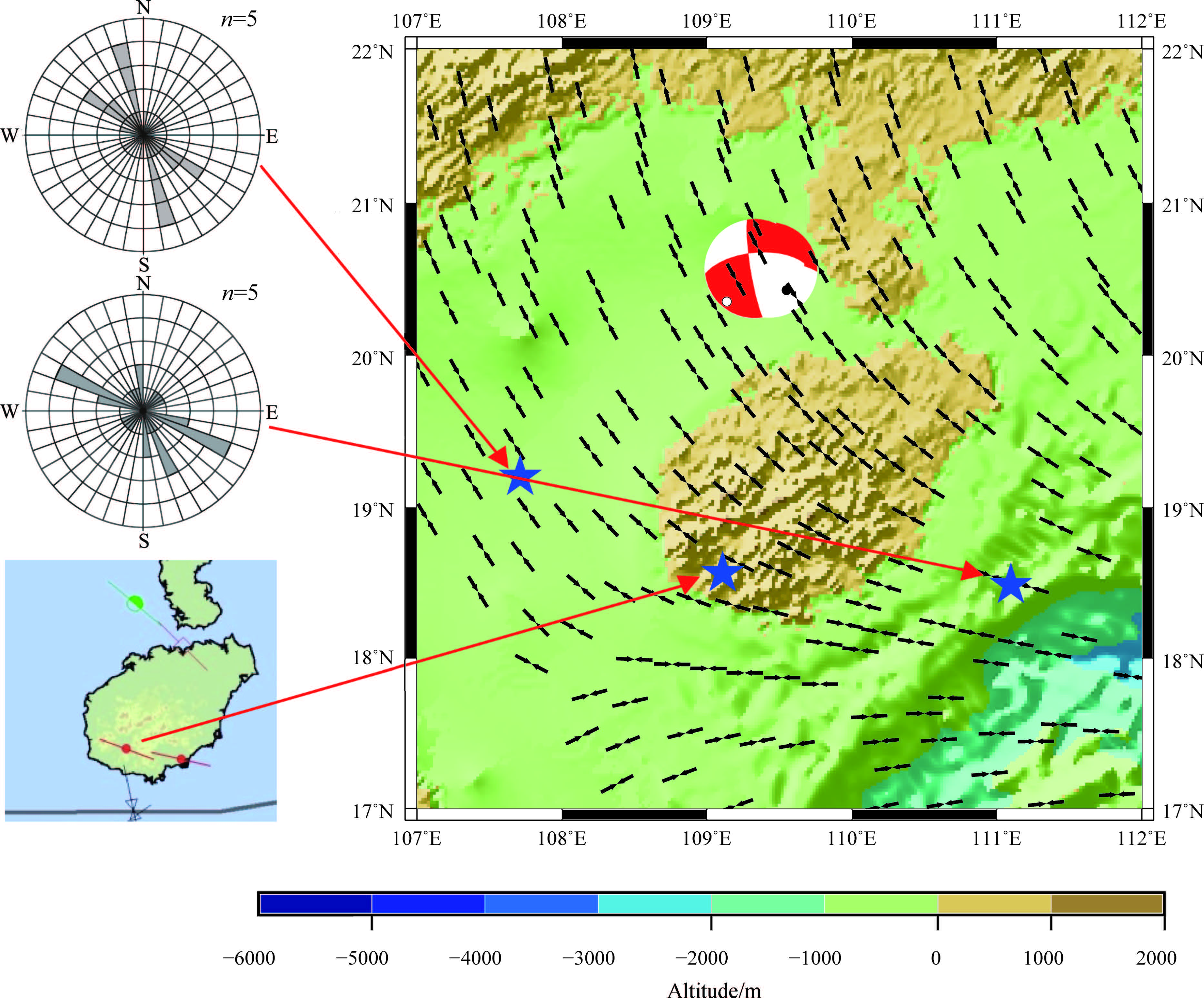
FMI logging can not only recognize rock type, structure, and fracturing, but also allow the extraction of the crustal stress around a drilling well. While drilling, the drilling fluid pressure is not completely balanced with the surrounding rock stress; thus, induced fracture can occur in the direction of maximum horizontal principal stress, or the wellbore hole can break in the direction of minimum horizontal principal stress(Zoback et al., 2003; Zoback et al., 2007). As such, FMI has been become an important technique for obtaining crustal stress status. In recent years the FMI logging method has been used in the northern marginal basin of the South China Sea. In this study, we interpreted two well FMI logs located in the Yinggehai and Qiongdongnan basins, respectively(Fig. 4). The FMI logging data quality is low, and the crustal status is interpreted from the data with difficulty. Nevertheless, the directions of maximum horizontal principal stress are found to be NW-NNW in the Yinggehai basin and NWW in Qiongdongnan basin, respectively(Fig. 5).
|
Fig.4
Characteristics of borehole breakout and drilling-induced fracture from FMI (a)Drilling-induced fracture;(b)Borehole breakout. |
|
Fig.5
Stress information extracted from FMI (a)Maximum principal stress from borehole breakout and drilling-induced fracture in one well of the Yinggehai basin;(b)Maximum principal stress from borehole breakout and drilling-induced fracture in one well of the Qiongdongnan basin. Solid circles represent the results from borehole breakout. Hollow circles represent the results of drilling-induced fracture. |
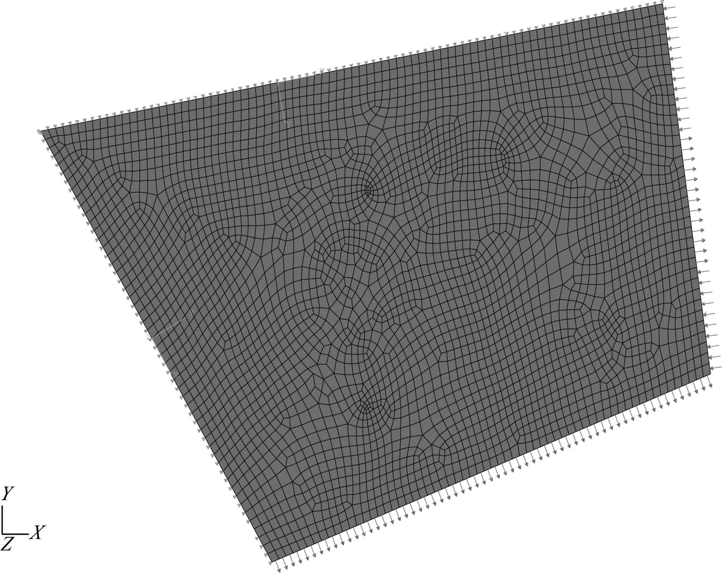
The northern South China Sea constitutes the main area of the FE numerical model constructed here, which is bounded by the NEE-striking offshore fault to the north, the Red River to east and Vietnam fault to the west, the ocean ridge of the South China Sea to the south, and the Manila trench to the east. The boundary conditions vary along the trench from Taiwan Isl and to Luzon, which is controlled by the tectonic environment(Fig. 6). The western and northern boundary conditions are normally constraints and tangentially free. The southern boundary is applied by an extensional normal stress of 0.6 MPa. The eastern boundary is separated into three sections, each of which are assigned a different load. The boundary loads near Taiwan and Luzon are compressive normal pressures of 7 and 1.2 MPa, respectively, whereas the middle section load between them is an extensional normal stress of 5.5 MPa. The constitutive relation of the model is linear viscoelasticity. Physical properties of model are derived from crustal rheological structures(Shi and Cao, 2008)with the Yang’s modulus of 5.0×10¹⁰ Pa, Poisson ratio of 0.3, rate of shear relaxation modulus gR(∞)= GR(∞)/G0 of 0.2, and a relaxation time τ of 2.0×10¹² s.
|
Fig.6 FE mesh model with boundary conditions and loads |
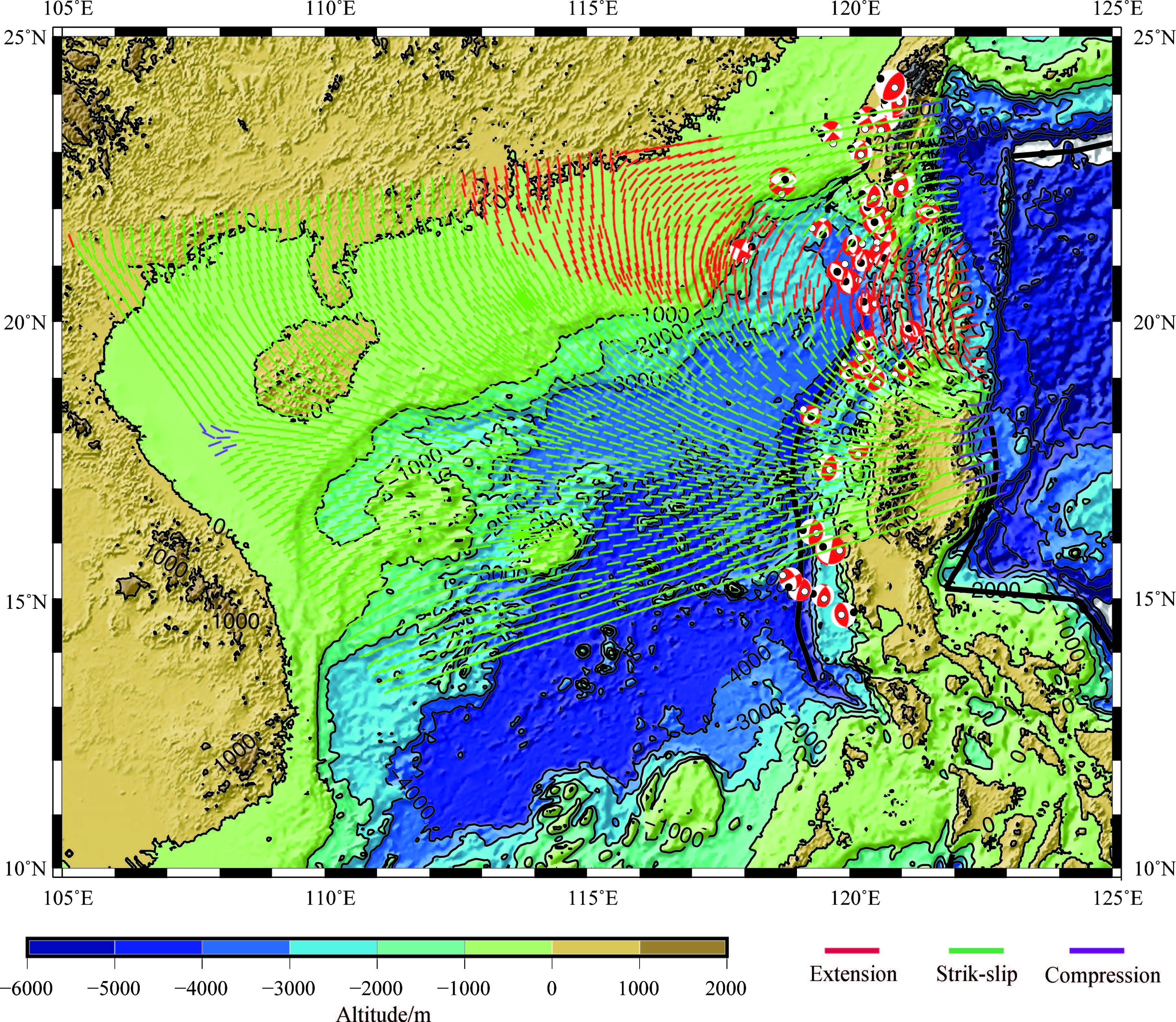
In addition to in situ stress measurements and FMI logging stress analysis, focal mechanisms represent an important way of obtaining the crustal stress status. On Dec. 31, 1994, and Jan. 10, 1995, earthquakes of Ms 5.3 and Ms 5.5 occurred near the adjoining area between Guangdong, Guangxi, and Hainan provinces, with epicenters of 20°26'N, 109°21'E, and 20°29'N, 109°21'E, respectively. Focal mechanism solutions of these earthquakes show that the direction of maximum horizontal principal stress is NNW.With constraint of observed stress data, a two-dimensional plane crustal stress field can be simulated using a 2D plane stress finite element model(Fig. 7). The modeled stress field shows that the present stress status of the northern South China Sea is dominated by the influences of the Philippine, South China, and India-Australia plates. The Manila trench is the boundary of the Philippine plate and the South China Sea block, along which different forms of impact are present: continental collision at Taiwan and Luzon, and subduction between Taiwan and Luzon. In particular, the subduction induces a drag force on the South China Sea block, which results in stress partitioning. Along the margin of the northern South China Sea, the direction of maximum horizontal principal stress transforms gradually from E-W, NEE near Taiwan, to NNW, NW in Yinggehai, Qiongzhou, and Zhujiangkou basins. This is consistent with the observed stress field of South China provided by the “Basis Database of Crustal Stress Environment” compiled by the Institute of Crustal Dynamics, CEA. In Hainan Isl and , the direction of maximum horizontal stress transforms gradually from NNW to NWW(Fig. 8).
|
Fig.7 Modeled maximum principal horizontal stress in the northern South China Sea |
|
Fig.8
Modeled maximum principal horizontal stress in Hainan Isl and and its surrounding regions in the northern South China(the maximum principal horizontal stress) Two rose diagrams show the directions of maximum principal stress deduced from FMI and the image in the lower left corner shows the direction of maximum principal stress from in situ measurements. |
This work is based on in situ stress measurement and FMI data from drilling wells in the sea. The purpose is to underst and stress state of the northern South China Sea. The results show that the horizontal maximum principal stress near Hainan Isl and is in NW-NWW direction. The measured crustal stress is much lower than that required for fault reactivation according to the Byerlee’s criteria; thus the faults near the measurement point are inactive and the crust is stable. With the constraint of the observed crustal stress and considering the geodynamic environment around the northern South China Sea, the stress field is simulated using a finite element model. The numerical modeling results show:(1)The present stress status of northern South China Sea is variably dominated by the Philippine plate, the South China plate and the India-Australian plate, and the stress properties changes from one region to another;(2)Near Taiwan, the direction of maximum horizontal principal stress is nearly E-W, as a result of the collision of the Euro-Asia and Philippine plates; and (3)Westward along the north margin of the sea the direction of maximum horizontal principal stress transforms from E-W near Taiwan to the S-N near Zhujiangkou, and NNW near Hainan. The modeling results are not perfect, due to limitation of observed stress data. With an increase in the amount of observed stress data, the modeled tectonic stress field will be more detailed and precise.
ACKNOWLEDGMENTSWe thank the Hainan Institute of Geological Engineering for drilling the well, the CMT project of Harvard University for focal mechanism data, and the Institute of Crustal Dynamics, CEA for the “Basis Database of Crustal Stress Environment.” This study was supported by Chinese Geological Survey Projects(1212011220122, 12120114002401).
| [1] | Bautista B C, Bautista M L P, Oike K, et al. 2001. A new insight on the geometry of subducting slabs in northern Luzon, Philippines. Tectonophysics, 339(3-4):279-310. |
| [2] | Briais A, Patriat P, Tapponier P. 1993. Updated interpretation of magnetic anomalies and seafloor spreading stages in the South China Sea:Implications for the Tertiary tectonics of South-east Asia. J. Geophys. Res., 98(B4):6299-6328. |
| [3] | Byerlee J D. 1978. Friction of rocks. Pure and Applied Geophysics, 116(4-5):615-626. |
| [4] | Chen Q C, Feng C J, Meng W, et al. 2012. Analysis of in situ stress measurements at the northeastern section of the Longmenshan Fault Zone after 5.12 Wenchuan earthquake. Chinese J. Geophys. (in Chinese), 55(12):3923-3932, doi:10.6038/j.issn. 0001 5733. 2012. 12. 005. |
| [5] | Fan T Y, Long C X, Yang Z Y, et al. 2012. Comprehensive modeling on the present crustal stress of China mainland with the viscoelastic spherical shell. Chinese J. Geophys. (in Chinese), 55(4):1249-1260, doi:10.6038/j. issn. 0001 5733.2012.40. 020. |
| [6] | Haimson B C, Cornet F H. 2003. ISRM suggested methods for rock stress estimation-Part 3:hydraulic fracturing(HF) and/or hydraulic testing of pre-existing fractures (HTPF). International Journal of Rock Mechanics & Mining Sciences, 40(7-8):1011-1020. |
| [7] | Hall R, van Hattum M W A, Spakman W. 2008. Impact of India-Asia collision on SE Asia:the record in Borneo. Tectonophysics, 451(1-4):366-389. |
| [8] | Hsu Y J, Yu S B, Song T R A, et al. 2012. Plate coupling along the Manila subduction zone between Taiwan and northern Luzon. Journal of Asian Earth Sciences, 51:98-108. |
| [9] | Jaeger J C, Cook N G W, Zimmerman R. 2009. Fundamentals of Rock Mechanics. New York:John Wiley & Sons. |
| [10] | Ku C Y, Hsu S K. 2009. Crustal structure and deformation at the northern Manila Trench between Taiwan and Luzon islands. Tectonophysics, 466(3-4):229-240. |
| [11] | Lee T Y, Lawver L A. 1995. Cenozoic plate reconstruction of Southeast Asia. Tectonophysics, 251:85-138. |
| [12] | Li F Q, Liu G X. 1986. In situ stress measurements, stress state of the upper crust and earthquake. China Earthquake(in Chinese), 2(1):50-55. |
| [13] | Li Y X, Zhang J H, Zhou W, et al. 2010. Current tectonic movement of South China sea and its surrounding areas. Journal of Geodesy and Geodynamics, 30(3):10-16. |
| [14] | Lin C S, Tang Y, Tan Y H. 2009. Geodynamic mechanism of dextral strike-slip of the western edge faults of the South China Sea. Acta Oceanologica Sinica (in Chinese), 31(1):159-167. |
| [15] | Lithgow-Bertelloni C, Guynn J H. 2004. Origin of the lithospheric stress field. J. Geophys. Res., 109, B01408, doi:10. 1029/2003JB002467. |
| [16] | Liu B M, Xia B, Li X X. 2006. Southeastern extension of the Red River fault zone(RRFZ) and its tectonic evolution significance in western South China Sea. Science in China:Series D Earth Sciences, 49(8):839-850. |
| [17] | Liu Y X, Zhan W H, Qiu X L et al. 1993. Study on recent tectonic stress field, recent crustal movement and crustal stability in South China Sea and its adjacent area. South China Journal of Seismology (in Chinese), 13(1):11-21. |
| [18] | Luan X W, Zhang L. 2009. Tectonic evolution modes of south China sea:passive spreading under complex actions. Marine Geology & Quaternary Geology, 29(6):59-74. |
| [19] | Meng W, Chen Q C, Du J J, et al. 2012. In site stress measurement in Singapore. Chinese J. Geophys. (in Chinese), 55(8):2611-2619, doi:10. 6038/j. issn. 0001 5733. 2012. 08. 012. |
| [20] | Pautot G, Rangin C. 1989. Subduction of the South China Sea axial ridge below Luzon (Philippines). Earth and Planetary Science Letters, 92(1):57-69. |
| [21] | Peltzer G, Tapponnier P. 1988. Formation and evolution of strike-slip faults, rifts, and basins during the India-Asia collision:An experimental approach. J. Geophys. Res., 93(B12):15085-15117. |
| [22] | Qiu X L, Liu Y X. 1989. A study of the modern tectonic stress field of South China Sea and its vicinity. Tropic Oceanology(in Chinese), 8(2):84-92. |
| [23] | Ren J Y, Lei C. 2011. Tectonic stratigraphic frame work of Yinggehai-Qiongdongnan Basin and its implication for tectonic province division in South China Sea. Chinese J. Geophys. (in Chinese), 54(12):3303-3314, doi:10.3969/J. ISSN. 0001-5733. 2011. 12. 028. |
| [24] | Rouchet J H. 1981. Stress fields, a key to oil migration. AAPG Bulletin, 65:74-85. |
| [25] | Scholz C H. 2002. The Mechanics of Earthquakes and Faulting. New York:Cambridge University Press. |
| [26] | Shi Y L, Cao J L. 2008. Effective viscosity of China continental lithosphere. Earth Science Frontiers (in Chinese), 15(3):82-95. |
| [27] | Sibson R H. 1994. Crustal stress, faulting and fluid flow.//Parnell J ed. Geofluids:Origin, Migration and Evolution of Fluids in Sedimentary Basins. Spec. Publs Geol. Sot. Lond., 78:69-84. doi:10.1144/GSL.SP.1994.078.01.07. |
| [28] | Stephan J R, Blanchet R, Rangin C, et al. 1986. Geodynamic evolution of the Taiwan-Luzon-Mindoro belt since the Late Ecocene. Tectonophysics, 125(1-3):245-268. |
| [29] | Tapponnier P, Peltzer G, Armijo R. 1986. On the mechanics of the collision between India and Asia. Geol. Soc. Spec. Publ., 19:113-157. |
| [30] | Turcotte D L, Schubert G. 2002. Geodynamics (2nd Edition). New York:Cambridge University Press. |
| [31] | Wang J. 2012. Modern movement and deformation in the South China Sea show by GPS measurements and numerical simulation[Ph. D. thesis] (in Chinese). Beijing:Graduate School of Chinese Academy of Science. |
| [32] | Wang P L, Lo C H, Chung S L, et al. 2000. Onset timing of left-lateral movement along the Ailao Shan-Red River Shear Zone:40Ar/39Ar dating constraint from the Nam Dinh Area, north eastern Vietnam. Journal of Asian Earth Sciences, 18(3):281-292. |
| [33] | Wu H L, Wang X F, Ma Y S, et al. 1999. Theory and method of studying hydrocarbon migration driven by tectonic stress field. Acta Petrolei Sinica, 20(5):7-12. |
| [34] | Wu M L, Liao C T. 2000. Stress measurements and study of stability of the Damao tunnel. Journal of Geomechanics (in Chinese), 6(2):71-76. |
| [35] | Wu M L, Zhang C S, Liao C T, et al. 2005. The recent state of stress in the central Qinghai-Tibet Plateau according to in-situ stress measurements. Chinese J. Geophys. (in Chinese), 48(2):327-332. |
| [36] | Wu M L, Ma Y S, Zhang C S, et al. 2008. In situ stress measurement and tectonic stress field study in the region of Lanzhou-Maqu. Chinese J. Geophys. (in Chinese), 51(5):1468-1474. |
| [37] | Xie F R, Cui X F, Zhao J T, et al. 2004. Regional division of the recent tectonic stress field in China and adjacent areas. Chinese J. Geophys. (in Chinese), 47(4):654-662. |
| [38] | Xu H L, Ye C M, Qiu X L, et al. 2010. Studies on the Binhai fault zone in the northern south China sea by the deep geophysical exploration and its seismogenic structure. South China Journal of Seismology (in Chinese), 30(S1):10-18. |
| [39] | Yang T F, Lee T, Chen C H, et al. 1996. A double island arc between Taiwan and Luzon:consequence of ridge subduction. Tectonophysics, 258(1-4):85-101. |
| [40] | Yao B C, Qiu Y, Li T G. 1999. The strike-slip characters of western margin of South China Sea-Wan'an fault and its tectonic significances.//Yao B C, Qiu Y, Wu N Y, eds. Character of Geology Tectonic and Cenozoic Depostion in the Western South China Sea (in Chinese). Beijing:Geological Publishing House, 45-55. |
| [41] | Zhou D, Ru K, Chen H Z. 1995. Kinematics of Cenozoic extension on the South China Sea continental margin and its implications for the tectonic evolution of the region. Tectonophysics, 251(1-4):161-177. |
| [42] | Zhu S B, Shi Y L. 2006. Study the controls of the tectonic stress of China mainland. Science in China Series D:Earth Sciences (in Chinese), 36(12):1077-1083. |
| [43] | Zoback M D. 2007. Reservoir Mechanics. New York:Cambridge University Press, 167-205. |
| [44] | Zoback M D. 2007. Reservoir Mechanics. New York:Cambridge University Press, 123-139. |
| [45] | Zoback M L. 1992. First- and second-order patterns of stress in the lithosphere:The world stress map project. J. Geophys. Res., 97(B8):11703-11728. |
| [46] | Zoback M D, Healy J H. 1992. In-situ stress measurements to 3.5 km depth in Cajon Pass Scientific Research Bore-hole:implications for the mechanics of crustal faulting. J. Geophys. Res., 97 (B4):5039-5057. |
| [47] | Zoback M D, Barton C A, Brudy M, et al. 2003. Determination of stress orientation and magnitude in deep wells. International Journal of Rock Mechanics and Mining Sciences, 40:1049-1076. |
| [48] | Zoback M D, Tsukahara H, Hickman S. 1985. Stress measurements in the vicinity of San Andreas fault:Implication for the magnitude of shear stress at depth. J. Geophys. Res., 85(B11):6157-6173. |
 2014, Vol. 57


