2 中国科学院大学, 北京 100049;
3 中国科学院地质与地球物理研究所, 中国科学院新生代地质与环境重点实验室, 北京 100029;
4 中国科学院青藏高原地球科学卓越创新中心, 北京 100101)
过去2000年是过去全球变化研究计划(PAGES)的重点研究时段,更好的理解年际至年代际甚至百年尺度的区域气候变化机制则是PAGES2k第三阶段的主题之一[1]。利用中国冰芯、树轮、石笋、湖泊沉积物和历史文献重建的温度记录,Ge等[2]集成了中国过去2000年的温度变化记录,发现存在4个百年尺度的冷期和暖期;Zheng等[3]则利用中国东部地区丰富的历史文献资料,重建了过去1500年的干湿变化,发现百年尺度上的4个干旱时期和3个湿润时期;Feng等[4]利用生物标志化合物GDGTs定量重建了过去2000年青藏高原东南部高分辨率的温度记录,揭示了清晰的百年尺度的温度变化,包括中世纪气候异常期(Medieval Climate Anomaly, 简称MCA)、小冰期(Little Ice Age, 简称LIA)和现代暖期(Current Warm Period, 简称CWP)。降水具有较强的区域性特点,青藏高原过去2000年的降水记录主要来自于冰芯[5]、树轮[6~7]、湖泊沉积物[8~9]等,这些记录覆盖的时间较短或分布在青藏高原的边缘区域,然而在中部地区长时间高分辨率的降水记录较少。
青藏高原是世界上平均海拔最高、面积最大的高原。由于其高海拔、缺氧、植被稀少等特点,生态环境及其容易受到气候变化和人类活动的影响。青藏高原也储存了世界上除南极洲和格陵兰岛之外最大面积的冰川。这些冰川是亚洲大多数主要河流的水源,包括印度河、恒河、雅鲁藏布江、长江和黄河等,为超过世界三分之一的人口提供了淡水资源[10]。冰川赋存状态、径流和未来淡水资源的利用都严重地受到气候变化的影响[11~13],同时也影响到人类对水资源的利用。基于不同的现代观测数据和气候记录,青藏高原的气候变化在季节尺度[14]、年代际尺度[13]、百年尺度[15]、千年尺度[16~17]、冰期间冰期尺度[18~19]上受到西风和季风的交替影响。例如,Schiemann等[14]指出西风环流季节性地影响青藏高原,夏季靠南冬季则靠北;冰川观测数据表明过去几十年里青藏高原东部和南部受到季风的影响而西北部受到西风的影响[13];在整个全新世时期,湖泊沉积物记录显示季风的进退极大地影响青藏高原,表现出千年尺度上季风和西风的相互作用[16~17]。
湖泊沉积物是研究过去气候环境变化的重要材料之一,青藏高原上面积超过1 km2的湖泊超过1000个[20]。因此利用青藏高原湖泊沉积物研究过去气候环境变化是一种良好的途径[9, 21~23]。在过去几十年中,青藏高原已经有数十条湖泊沉积物记录发表,这些记录提供了关于青藏高原过去气候环境变化的信息。例如,Gasse等[24]利用松木西错沉积物重建了一条13000年的记录,表明了早全新世暖湿的气候特点;Hou等[25]利用长链烯酮在青海湖重建了全新世夏季温度记录,揭示了距今5000~3500年的降温现象。青藏高原晚全新世和过去2000年的湖泊沉积物记录的主要测年手段为放射性碳同位素定年,测年样品类型主要包括植物残体[4, 9, 26~27]和全样有机碳[15, 28~30]。然而,基于全样有机碳获得的碳十四年龄容易受到源自流域内基岩和湿地带来的“老碳”影响,使得年龄偏老,这一现象也被称为“碳库效应”[31],尤其是在植被稀少的青藏高原。当湖泊处于相对稳定的沉积条件下,碳库年龄通常假设为是保持不变的,因此可以通过线性回归的方法获得其表层的年龄[15, 28~30, 32~33]或者直接利用表层的碳十四年龄[34~35],这个年龄被认为是其碳库年龄。然而,最近一些研究表明碳库年龄并不是一成不变的[30~31, 36~37],青藏高原湖泊沉积物中建立合适的年代序列还是一个巨大的挑战。
纹层是由湖泊沉积环境规律性变化而形成的不同层偶的沉积组合,尤其是以一年为一个循环的年纹层,可以提供可靠的年代控制[38~40]。世界上纹层研究最重要的工作之一是日本Suigetsu湖的年纹层。在长达46 m的沉积物岩芯中纹层计数可至52800年,为放射性碳同位素的校正提供了标尺[41~43]。中国纹层研究主要包括东北的玛珥湖[44~48]、河北的安固里淖[49]、柴达木盆地的苏干湖[50]和青藏高原库赛湖[21, 51]、新路海[8]和巴松错[26],提供了准确可靠的年代控制和气候记录。目前青藏高原上已经发现的纹层湖主要分布在北部和东南部[8~9, 26, 50~51],而中部没有纹层湖的报道。本文介绍了在青藏高原中部湖泊江错发现的纹层记录,利用纹层计数重建了过去2000年精确的年代序列,通过对纹层形成机制的分析提出粗颗粒厚度百分比(coarse%)这一指示降水的代用指标,重建了过去2000年的降水变化。
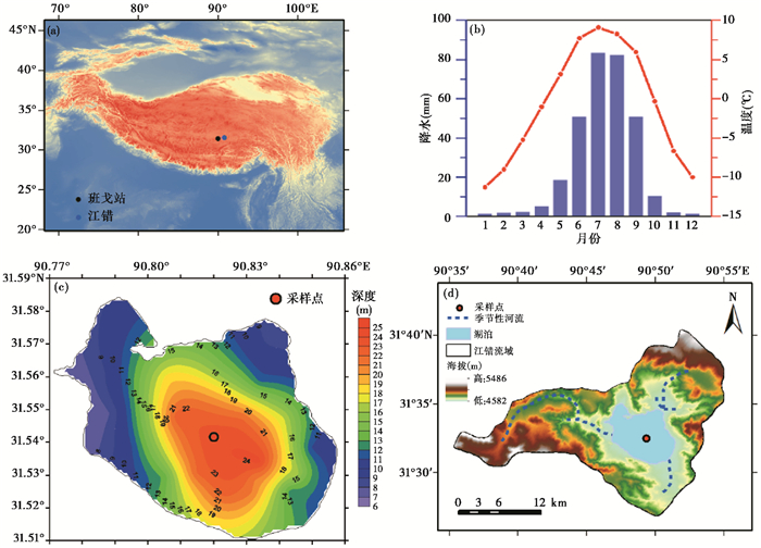
1 研究区概况江错(31°33′N,90°49′E;海拔4630 m)位于青藏高原中部,是一个单对流混合湖,距离西藏自治区那曲市班戈县东80 km2(图 1a),湖泊面积为36 km2,流域面积为310 km2,最大水深为25 m(图 1c)[52]。该湖主要受到降水补给,在6月至9月的雨季,湖的西部、东北部和南部分别有季节性河流注入(图 1d)。利用离江错最近的班戈县气象数据(图 1b)可得该地区的年平均气温为-2 ℃,年平均降水为350 mm,属于高原亚寒带气候,80%以上的降水集中在6~9月份,冬季12月至次年3月份湖面结冰。
|
图 1 江错和班戈站在青藏高原的位置(a)、班戈站1957~2015年月平均气温和降水(b)、江错等深线(c)以及江错流域图(d) Fig. 1 Location of Jiang Co and the Bange Meteorological Station on the Tibetan Plateau (a), monthly mean temperature and precipitation at the Bange Meteorological Station during 1957~2015 A. D. (b), bathymetric contour of Jiang Co (c) and catchment of Jiang Co (d) |
2013年我们已经开始对江错进行水化学指标的测量和表层沉积物采集工作。2014年利用UWITEC湖上岩芯钻探平台采集了一根长达6 m的沉积物岩芯,基于放射性碳同位素定年,年龄为18 ka[53]。在岩芯处理过程中,我们发现江错沉积物具有保存完好的纹层,因此在2015年9月利用重力钻重新采集了一根长达101 cm的沉积物岩芯JC15并随后将整根岩芯带回实验室进行处理。对JC15岩芯从中间对称劈成两半,其中一半用作纹层薄片的制作(图 2a),另一半以0.5 cm分辨率间隔分样,用来进行放射性碳同位素(14C)和核素(210Pb和137Cs)测年。

|
图 2 (a) 江错沉积柱JC15岩芯图、(b)偏光显微镜下纹层图片、(c)岩性显微镜下纹层图片和(d)纹层中粗颗粒层和细颗粒交替出现 Fig. 2 (a)Sediment core JC15 of Jiang Co, (b)varves in polarizing light, (c)varves in petrographic microscopy and (d)varves appear as couplets of fine-grain layer and coarse-grain layer |
利用分样工具将JC15岩芯切为130 mm×15 mm×10 mm的岩芯样条,样条之间两端各重合20 mm,放入铝盒中,用液氮进行速冻,随后冻干,冻干后的样品用环氧树脂渗入使样条固化,最后磨制纹层薄片。用记号笔在纹层大薄片上以1 cm间距标注岩芯深度,并记录每厘米层数。对偶层清晰的纹层数用最小值表示,对偶层清晰的纹层数和不是很清晰的纹层数之和用最大值表示。纹层最大值和最小值的差与纹层平均数的比值认为是纹层计年的误差。纹层厚度的测量则是利用偏光显微镜记录下纹层镜下的厚度进而转换成实际的厚度。本次纹层计数工作和纹层厚度测量工作在中国科学院地质与地球物理研究所新生代地质与环境重点实验室进行。
2.3 纹层微相和电子探针分析纹层微相分析是利用岩相显微镜分析纹层的结构和组成。纹层矿物元素的组成分析则是利用中国科学院青藏高原研究所大陆碰撞与高原隆升实验室的电子探针显微分析仪(JXA-8239 JEOL)。江错沉积物纹层薄片镀碳后上机分析。
2.4 放射性测年将JC15岩芯表层15 cm以0.5 cm间隔分样的样品冻干后用于210Pb和137Cs测年。测试前将样品研磨至100目以下,装入聚乙烯的塑料管中,并用Parafilm @ 封口胶密封三周,使得测量前达到平衡。利用美国ORTEC公司的高纯锗γ谱仪测量样品,时间为80000 s,获得210Pb和226Ra的比活度。过剩铅210Pbex的比活度为210Pb比活度减去226Ra的比活度,进而利用恒定放射性通量模型(Constant Rate of Supply,简称CRS)计算沉积物每层的年龄[54]。核试验产生的人工核素137Cs的年龄则通过在沉积物中的峰值确定。
JC15岩芯的两个全样有机质样品分别取自沉积物岩芯29.5~30.0 cm和59.5~60.0 cm处,用来进行放射性碳同位素定年分别为4085 a B.P. 和4460 a B.P.。测试仪器为AMS加速质谱仪,测试地点为中国科学院地球环境研究所。另一个位于99~100 cm处碳十四年龄则是由2014年长岩芯测得,年龄为5350 a B.P.[53]。
3 结果 3.1 纹层年代学和纹层厚度通过显微镜下观察我们初步认为江错纹层类型为碎屑-有机质纹层(图 2b),每一层由粗颗粒层和细颗粒层组成(图 2c和2d),粗颗粒层在细颗粒层的下部,粗颗粒层和下一个纹层的细颗粒层之间有一层薄薄的黑色条带,推测可能是有机质层,因此,每一个粗颗粒-细颗粒对偶层被认为是一层年纹层,条带被认为是新的一层出现的标志。
经过14次纹层计数,计数结果趋于稳定且最后两次计数结果一致,我们得到最终的纹层数目为1935,JC15岩芯年龄为公元81年至2015年。纹层数目最大值为1961,最小值为1909,每层纹层最大值和最小值之间的差值为每层纹层年龄的误差,整个岩芯纹层年代误差为2.7%。
经过镜下纹层厚度换算可得,粗颗粒层厚度分布为从0.0515 mm至4.635 mm,细颗粒层厚度分布为0.0515 mm至2.4205 mm,总纹层厚度分布为0.103 mm至5.150 mm,95%的纹层厚度小于1 mm。
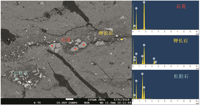
3.2 电子探针分析在电子探针显微分析仪中,纹层薄片可以清楚地看到深色粗颗粒层和浅色细颗粒层(图 3)。粗颗粒层内含有直径达几十至数百微米的矿物,这些矿物包含石英、钾长石、红柱石等外源矿物。
|
图 3 纹层显微图像和粗颗粒层中矿物电子探针元素分析结果 Fig. 3 Micro photo and element analysis of EPMA and mineral particles in coarse-grain layer |
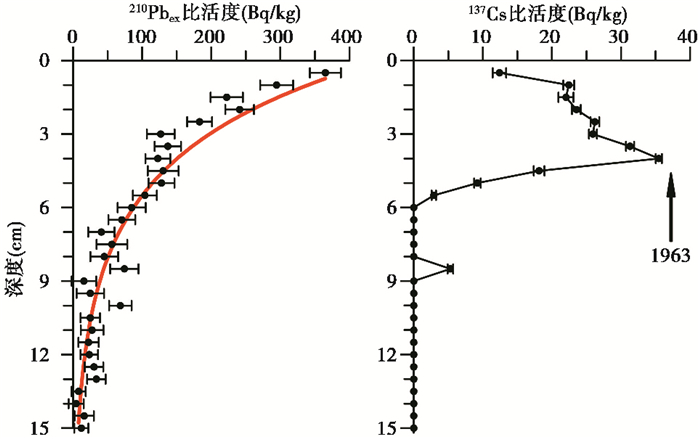
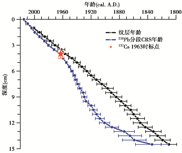
JC15柱表层15 cm的沉积物岩芯中,210Pbex的比活度呈指数分布,同时137Cs的最高值峰(37.46 Bq/kg)出现在3.5~4.0 cm处,8.0~8.5 cm处也出现了一个小峰(图 4)。通常认为137Cs的峰代表1963年全球范围的核爆试验导致的沉降最高值,然而1986年切尔诺贝利核电站发生的核泄漏事件并未在此出现,这一现象也出现在青藏高原其他湖泊沉积物记录中[8, 22~23, 55~57]。我们认为8.0~8.5 cm处的小峰并不代表任何一个时标事件,可能由于137Cs在沉积物中的迁移导致[58]。210Pb的年龄则是由分段CRS模型[54]求得,由137Cs的1963年时标点作为分段标准,分为0~4 cm和4 cm以下两个部分。210Pb的年龄误差则是由测量误差导致的210Pbex的误差通过CRS模型求得,如图 5所示,与纹层年龄对比可得0~4 cm年龄在误差范围内有较好的对应关系,4 cm以下存在一些偏差可能由于测量和模型误差导致。
|
图 4 江错沉积物中210Pbex和137Cs比活度随深度变化曲线 Fig. 4 Activity of 210Pbex and 137Cs versus depth in the sediment of Jiang Co |
|
图 5 江错沉积物中纹层年龄和210Pb年龄、137Cs年龄对比 Fig. 5 Comparison of varve ages, 210Pb and 137Cs ages in the sediment core of Jiang Co |
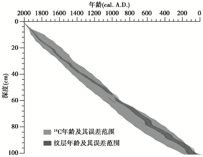
位于29.5~30.0 cm、59.5~60.0 cm和99~100 cm处的碳十四年龄分别为4085 a B.P.、4460 a B.P. 和5350 a B.P.。通过线性回归的方法求得碳库年龄为3473年,利用Bacon模型[59]得到95%置信区间的年龄框架。与纹层年龄对比发现,在误差范围内,碳十四年龄和纹层年龄基本一致(图 6)。
|
图 6 江错沉积物中纹层年龄和14C年龄对比 灰色曲线和灰色阴影为14C年龄及误差范围,黑色曲线和黑色阴影为纹层年龄及误差范围 Fig. 6 Comparison of varve ages and 14C ages in the sediment core of Jiang Co, gray curve and gray shadow are 14C age and its error, black curve and black shadow are varve age and its error |
通过显微镜观测纹层薄片可以看到江错的纹层由碎屑层和有机质层组成,其中主要的碎屑层又分为粗颗粒层和细颗粒层。碎屑层的物质主要来源于流域内的基岩,在冷干条件下基岩受到强烈的风化作用,碎屑物质通过径流进入湖泊中,这种类型的纹层在世界上极地和高山地区的湖泊沉积物中也经常出现[40]。有机质层的物质则主要来源于湖泊内部,野外观察发现江错分布有数量庞大的西藏溞(Daphnia tibetana)和少量水生植物[60]。
电子探针分析的结果表明粗颗粒层和细颗粒层的来源不一致(见图 3)。粗颗粒层中存在一些大颗粒的矿物,包括石英、钾长石和红柱石等,这些矿物来自湖泊外部,主要由径流带入湖中;细颗粒层则主要包括一些外源的碎屑和湖泊自生的碳酸盐。
因此,江错纹层形成机制可能如下。在江错流域中,6~9月的降水占全年降水的80%以上,江错沉积物中的碎屑物质主要来源于流域岩石风化产物经季节性的径流进入到湖泊中。在夏季,粗颗粒的碎屑物质因重量大而先沉积,同时细颗粒的碎屑物质如粉砂、粘土等悬浮在湖泊水柱中。到冬季的时候,江错湖面结冰,湖水内部水流动力减弱,水柱中的细颗粒碎屑和有机质沉积,冬季死亡的浮游生物则是这些有机质的来源之一。因此,由图 2可见江错纹层由粗颗粒层和细颗粒层组成,而且岩芯中较厚的粗颗粒层可能指示极端降水事件,更多的降水携带颗粒更大、数量更多的粗颗粒碎屑进入湖中。
对比纹层年代和210Pb、137Cs和14C的年代也可以证明江错的纹层是年纹层。137Cs在1963年的时标点在误差范围内与纹层年龄有很好的一致性,因此我们利用137Cs的时标点对210Pb进行分段CRS模型的计算,分为0~4 cm和4~15 cm两段。结果表明0~4 cm内210Pb的年龄和纹层年龄也相对一致,然而在4~15 cm这一段则有一些误差。观察210Pbex比活度曲线可知(见图 4),在底部有些210Pbex的比活度点偏离指数拟合线,这给利用分段CRS模型计算年龄时造成了较大的误差,可能是导致下部210Pb年龄和纹层年龄不一致的原因。经过碳库校正,利用Bacon模型[59]得到14C的年代框架和纹层的年代在误差范围内基本一致,证明在整个岩芯中纹层计数得到的纹层年代是可靠的。
综上所述,经过纹层形成机制分析和独立的其他年代方法的验证,江错沉积物中的纹层是年纹层且纹层年代是准确可靠的。
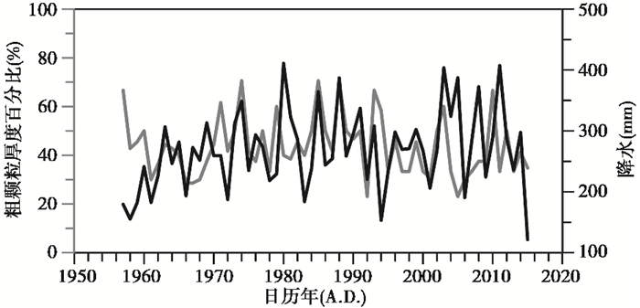
4.2 粗颗粒厚度百分比(coarse%)作为降水指标的指示意义过去的研究表明纹层厚度可以反映过去气候环境的变化,例如温度、降水、风和洪水等[40, 51, 61]。江错流域内没有发育冰川,湖水主要由降水补给,降水形成的径流则可以将陆地的物质带入湖泊中。纹层厚度的变化受到径流带来的外源物质多少所控制[8]。在江错流域内,6~9月份的降水量占全年降水量的80%以上,可以代表全年降水的变化,外源碎屑物质主要在这一时间段随径流进入湖中。降水量多的时候产生更强的侵蚀和径流,可以携带更多的粗颗粒物质进入湖中;反之,降水量少的的时候,粗颗粒物质相对就少。因此我们提出每个纹层中粗颗粒厚度百分比(coarse%)作为指示过去全年降水的指标,公式如下:粗颗粒厚度百分比=粗颗粒层厚度/纹层总厚度。为了验证这一指标的可靠性,我们对比了1957年至2015年的江错粗颗粒厚度百分比(coarse%)与班戈气象站夏季6~9月的逐年降水数据(图 7)。岩芯在野外运输至实验室的过程中表层岩芯可能会受到压实作用,去趋势分析后利用相关分析可得Pearson相关系数为0.252,P值为0.054。因此我们认为粗颗粒厚度百分比(coarse%)是可以作为指示过去降水的指标。
|
图 7 1957年至2015年江错粗颗粒厚度百分比(灰色曲线)和班戈气象站6~9月年平均降水数据(黑色曲线)对比 Fig. 7 Comparison of coarse-grain thickness percentage (gray curve)in the Jiang Co sediment core and annual mean precipitation (black curve)of sum of June to September(JJAS)at the Bange Meteorological Station from 1957 A.D. to 2015 A.D. |
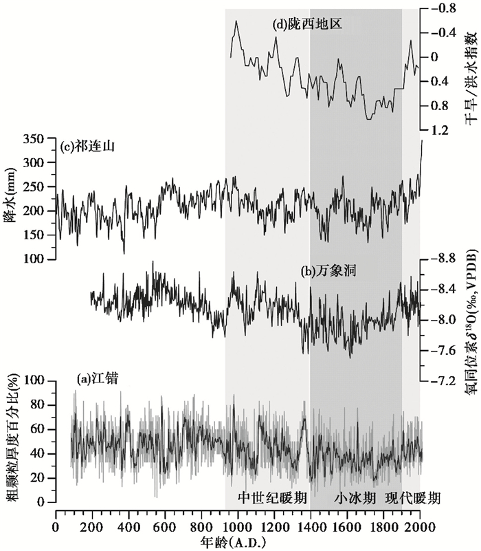
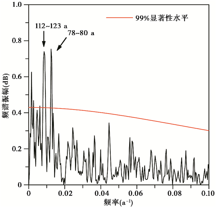
基于粗颗粒厚度百分比(coarse%)这一指标我们重建了江错过去2000年的降水记录,记录显示出强烈的波动性(图 8a)。高频的变化可能包含测量的误差,因此我们利用9点低频高斯滤波方法平滑了曲线,突出年代际-百年尺度的变化。江错过去2000年的降水记录呈现出1000~1400年中世纪暖期(MWP)降水多,1400~1900年小冰期(LIA)降水少,近百年暖期降水多的特点。我们将江错的降水记录和附近其他指示降水的记录对比,包括万象洞的石笋氧同位素记录(图 8b)[62]、祁连山的树轮重建的降水记录(图 8c)[7]、陇西地区的历史文献重建的干湿指数记录(图 8d)[63],这些记录和江错的降水记录表现出相似的特点。万象洞的石笋氧同位素记录表明中世纪暖期亚洲季风强,小冰期亚洲季风弱的特点,说明江错也受到亚洲季风的影响,季风强时带来更多的降水;祁连山树轮重建年际的降水记录证明江错年纹层也同样可以重建年际的降水记录;陇西地区的历史文献资料中重建的干湿变化也在过去1000年中与江错降水变化一致。通过REDFIT软件中的频谱分析[64],我们发现江错的降水具有百年的周期,两个显著性高于99%的周期分别为78~80 a、112~123 a(图 9)。Gleissberg周期是太阳活动周期的一种,其周期范围为60~150 a,典型周期为88 a[65~66],我们认为江错降水的百年周期可能受到这一太阳活动周期的影响。
|
图 8 江错粗颗粒厚度百分比(细线)和其9点高斯滤波结果(粗黑线) (a)与万象洞石笋氧同位素记录[62] (b)、祁连山树轮降水记录[7] (c)和陇西地区历史文献干湿指数记录[63] (d)对比 Fig. 8 Comparison of the percentage of coarse-grain fraction of lake sediment from Jiang Co(light curve) and a 9-point Gaussian filter result (dark black curve) (a), δ18O of stalagmite from Wanxiang Cave[62] (b), reconstructed precipitation from tree rings in the Qilian Mountains[7](c)and Drought/Flood Index in the Longxi area reconstructed from Chinese historical documents[63](d) |
|
图 9 江错粗颗粒厚度百分比的频谱分析 Fig. 9 Spectral analysis of the percentage of the coarse-grain sediment fraction from Jiang Co |
通过对青藏高原中部湖泊江错岩芯JC15的纹层沉积物分析,建立了过去2000年准确可靠的年代序列,初步探讨了纹层形成机制并且提出粗颗粒厚度百分比这一反映降水的指标,重建了过去2000年江错的降水变化。主要结论如下:
(1) 经过纹层计数,江错沉积物岩芯JC15年龄结果为公元81年至2015年。岩相显微镜和电子探针分析可以看出江错纹层类型为碎屑-有机质纹层,层偶为夏季形成的外源大颗粒矿物组成的粗颗粒层和冬季形成的小颗粒和自生碳酸盐组成的细颗粒层。独立的放射性元素定年方法,包括210Pb、137Cs和14C等,证明江错的纹层是年纹层。
(2) 通过对江错纹层形成机制分析,提出粗颗粒厚度百分比(coarse%)可以作为指示降水的指标,重建结果与现代气象观测记录有较好的对应关系。
(3) 过去2000年中,江错降水呈现出中世纪暖期(公元1000~1400年)降水多、小冰期(公元1400~1900年)降水少、现代暖期(公元1900年至今)降水多的特点,与区域内其他降水记录具有一致性,可能受到亚洲季风的控制。频谱分析表明江错的降水记录具有78~80 a、112~123 a的百年尺度周期,因此可能受到Gleissberg太阳活动周期的影响。
致谢: 感谢高少鹏老师和谢静老师在实验工作中提供的帮助;感谢审稿专家和编辑部杨美芳老师提出的宝贵意见和建议。
| [1] |
von Gunten L, Abram N, Bothe O, et al. The PAGES2k Network: Status Update on Phase Three Projects[M]. Washington: AGU Fall Meeting Abstracts, 2018.
|
| [2] |
Ge Q, Hao Z, Zheng J, et al. Temperature changes over the past 2000 yr in China and comparison with the Northern Hemisphere[J]. Climate of the Past, 2013, 9(3): 1153-1160. DOI:10.5194/cp-9-1153-2013 |
| [3] |
Zheng J, Wang W-C, Ge Q, et al. Precipitation variability and extreme events in Eastern China during the past 1500 years[J]. Terrestrial, Atmospheric and Oceanic Sciences, 2006, 17(3): 579. DOI:10.3319/TAO.2006.17.3.579(A) |
| [4] |
Feng X, Zhao C, D'Andrea W J, et al. Temperature fluctuations during the Common Era in subtropical Southwestern China inferred from brGDGTs in a remote alpine lake[J]. Earth and Planetary Science Letters, 2019, 510: 26-36. DOI:10.1016/j.epsl.2018.12.028 |
| [5] |
Yao T, Duan K, Xu B, et al. Precipitation record since AD 1600 from ice cores on the central Tibetan Plateau[J]. Climate of the Past, 2008, 4(3): 175-180. DOI:10.5194/cp-4-175-2008 |
| [6] |
Shao X, Xu Y, Yin Z Y, et al. Climatic implications of a 3585-year tree-ring width chronology from the northeastern Qinghai-Tibetan Plateau[J]. Quaternary Science Reviews, 2010, 29(17): 2111-2122. |
| [7] |
Yang B, Qin C, Wang J, et al. A 3, 500-year tree-ring record of annual precipitation on the northeastern Tibetan Plateau[J]. Proceedings of the National Academy of Sciences of the United States of America, 2014, 111(8): 2903. DOI:10.1073/pnas.1319238111 |
| [8] |
Chu G, Sun Q, Yang K, et al. Evidence for decreasing South Asian summer monsoon in the past 160 years from varved sediment in Lake Xinluhai, Tibetan Plateau[J]. Journal of Geophysical Research: Atmospheres, 2011, 116: 11. DOI:10.1029/2010jd014454 |
| [9] |
郭超, 马玉贞, 刘杰瑞, 等. 过去2000年来西藏羊卓雍错沉积物粒度记录的气候变化[J]. 第四纪研究, 2016, 36(2): 405-419. Guo Chao, Ma Yuzhen, Liu Jierui, et al. Climatic change recorded by grain-size in the past about 2000 years from Yamzhog Yumco Lake, Tibet[J]. Quaternary Sciences, 2016, 36(2): 405-419. |
| [10] |
Immerzeel W W, van Beek L P H, Bierkens M F P. Climate change will affect the Asian water towers[J]. Science, 2010, 328(5984): 1382-1385. DOI:10.1126/science.1183188 |
| [11] |
Farinotti D, Longuevergne L, Moholdt G, et al. Substantial glacier mass loss in the Tien Shan over the past 50 years[J]. Nature Geoscience, 2015, 8: 716. DOI:10.1038/ngeo2513 |
| [12] |
Huss M, Hock R. Global-scale hydrological response to future glacier mass loss[J]. Nature Climate Change, 2018, 8(2): 135-140. DOI:10.1038/s41558-017-0049-x |
| [13] |
Yao T, Thompson L, Yang W, et al. Different glacier status with atmospheric circulations in Tibetan Plateau and surroundings[J]. Nature Climate Change, 2012, 2(9): 663. DOI:10.1038/nclimate1580 |
| [14] |
Schiemann R, Lüthi D, Schär C. Seasonality and interannual variability of the Westerly Jet in the Tibetan Plateau region[J]. Journal of Climate, 2009, 22(11): 2940-2957. DOI:10.1175/2008JCLI2625.1 |
| [15] |
Sun Z, Yuan K, Hou X, et al. Centennial-scale interplay between the Indian summer monsoon and the Westerlies revealed from Ngamring Co, southern Tibetan Plateau[J]. The Holocene, 2020, 30(8): 1163-1173. DOI:10.1177/0959683620913930 |
| [16] |
Hou J, D'Andrea W J, Wang M, et al. Influence of the Indian monsoon and the subtropical jet on climate change on the Tibetan Plateau since the Late Pleistocene[J]. Quaternary Science Reviews, 2017, 163: 84-94. DOI:10.1016/j.quascirev.2017.03.013 |
| [17] |
李秀美, 侯居峙, 王明达, 等. 季风与西风对青藏高原全新世气候变化的影响: 同位素证据[J]. 第四纪研究, 2019, 39(3): 678-686. Li Xiumei, Hou Juzhi, Wang Mingda, et al. Influence of monsoon and westerlies on Holocene climate change in the Tibetan Plateau: Isotopic evidence[J]. Quaternary Sciences, 2019, 39(3): 678-686. |
| [18] |
An Z, Colman S M, Zhou W, et al. Interplay between the Westerlies and Asian monsoon recorded in Lake Qinghai sediments since 32 ka[J]. Scientific Reports, 2012, 2: 619. DOI:10.1038/srep00619 |
| [19] |
Zhu L, Lü X, Wang J, et al. Climate change on the Tibetan Plateau in response to shifting atmospheric circulation since the LGM[J]. Scientific Reports, 2015, 5: 13318. DOI:10.1038/srep13318 |
| [20] |
Ma R, Yang G, Duan H, et al. China's lakes at present: Number, area and spatial distribution[J]. Science China: Earth Sciences, 2011, 54(2): 283-289. DOI:10.1007/s11430-010-4052-6 |
| [21] |
倪振宇, 王永波, 刘兴起. 青藏高原北部库赛湖自生碳酸盐稳定同位素记录的晚全新世气候组合特征[J]. 第四纪研究, 2016, 36(4): 961-969. Ni Zhenyu, Wang Yongbo, Liu Xingqi. Late Holocene climatic combination on the northern Tibetan Plateau based on stable isotope analysis of authigenic carbonate from Kusai Lake[J]. Quaternary Sciences, 2016, 36(4): 961-969. |
| [22] |
许腾, 朱立平, 王君波, 等. 青藏高原北部冰前湖沉积记录的中晚全新世冰川活动[J]. 第四纪研究, 2019, 39(3): 717-730. Xu Teng, Zhu Liping, Wang Junbo, et al. Glacial activity since the mid-Late Holocene reconstructed by the proglacial Lake Buruo Co, northern Tibetan Plateau[J]. Quaternary Sciences, 2019, 39(3): 717-730. |
| [23] |
朱少航, 朱立平, 王君波, 等. 西藏玛旁雍错沉积揭示的晚冰期以来环境变化[J]. 第四纪研究, 2019, 39(3): 602-614. Zhu Shaohang, Zhu Liping, Wang Junbo, et al. Environmental changes reflected by core sediments since Late Glacial in Mapam Yumco, southwest Tibet of China[J]. Quaternary Sciences, 2019, 39(3): 602-614. |
| [24] |
Gasse F, Arnold M, Fontes J C, et al. A 13, 000-year climate record from western Tibet[J]. Nature, 1991, 353(6346): 742-745. DOI:10.1038/353742a0 |
| [25] |
Hou J, Huang Y, Zhao J, et al. Large Holocene summer temperature oscillations and impact on the peopling of the northeastern Tibetan Plateau[J]. Geophysical Research Letters, 2016, 43(3): 1323-1330. DOI:10.1002/2015GL067317 |
| [26] |
Li K, Liu X, Wang Y, et al. Late Holocene vegetation and climate change on the southeastern Tibetan Plateau: Implications for the Indian summer monsoon and links to the Indian Ocean Dipole[J]. Quaternary Science Reviews, 2017, 177: 235-245. DOI:10.1016/j.quascirev.2017.10.020 |
| [27] |
Guo C, Ma Y, Meng H, et al. Changes in vegetation and environment in Yamzhog Yumco Lake on the southern Tibetan Plateau over past 2000 years[J]. Palaeogeography, Palaeoclimatology, Palaeoecology, 2018, 501: 30-44. DOI:10.1016/j.palaeo.2018.04.005 |
| [28] |
Li X, Liang J, Hou J, et al. Centennial-scale climate variability during the past 2000 years on the central Tibetan Plateau[J]. The Holocene, 2015, 25(6): 892-899. DOI:10.1177/0959683615572852 |
| [29] |
Li X, Wang M, Hou J. Centennial-scale climate variability during the past 2000 years derived from lacustrine sediment on the western Tibetan Plateau[J]. Quaternary International, 2019, 510: 65-75. DOI:10.1016/j.quaint.2018.12.018 |
| [30] |
Zhang Q, Liu X, Li H. Impact of hydrological conditions on the radiocarbon reservoir effect in lake sediment 14C dating: The case of Kusai Lake on the northern Qinghai-Tibet Plateau[J]. Quaternary Geochronology, 2021, 62: 101149. DOI:10.1016/j.quageo.2020.101149 |
| [31] |
Hou J, D'Andrea W J, Liu Z. The influence of C-14 reservoir age on interpretation of paleolimnological records from the Tibetan Plateau[J]. Quaternary Science Reviews, 2012, 48: 67-79. DOI:10.1016/j.quascirev.2012.06.008 |
| [32] |
Fontes J-C, Gasse F, Gibert E. Holocene environmental changes in Lake Bangong basin(Western Tibet). Part 1: Chronology and stable isotopes of carbonates of a Holocene lacustrine core[J]. Palaeogeography, Palaeoclimatology, Palaeoecology, 1996, 120(1): 25-47. |
| [33] |
Wu Y, Li S, Lücke A, et al. Lacustrine radiocarbon reservoir ages in Co Ngoin and Zigê Tangco, central Tibetan Plateau[J]. Quaternary International, 2010, 212(1): 21-25. DOI:10.1016/j.quaint.2008.12.009 |
| [34] |
Herzschuh U, Winter K, Wünnemann B, et al. A general cooling trend on the central Tibetan Plateau throughout the Holocene recorded by the Lake Zigetang pollen spectra[J]. Quaternary International, 2006, 154-155: 113-121. DOI:10.1016/j.quaint.2006.02.005 |
| [35] |
Wang J, Zhu L, Wang Y, et al. Variability of the 14C reservoir effects in Lake Tangra Yumco, central Tibet(China), determined from recent sedimentation rates and dating of plant fossils[J]. Quaternary International, 2017, 430: 3-11. DOI:10.1016/j.quaint.2015.10.084 |
| [36] |
Watanabe T, Matsunaka T, Nakamura T, et al. Last glacial-Holocene geochronology of sediment cores from a high-altitude Tibetan lake based on AMS 14C dating of plant fossils: Implications for paleoenvironmental reconstructions[J]. Chemical Geology, 2010, 277(1): 21-29. |
| [37] |
Zhang J, Ma X, Qiang M, et al. Developing inorganic carbon-based radiocarbon chronologies for Holocene lake sediments in arid NW China[J]. Quaternary Science Reviews, 2016, 144: 66-82. DOI:10.1016/j.quascirev.2016.05.034 |
| [38] |
O'Sullivan P E. Annually-laminated lake sediments and the study of Quaternary environmental changes-A review[J]. Quaternary Science Reviews, 1983, 1(4): 245-313. DOI:10.1016/0277-3791(83)90008-2 |
| [39] |
Ojala A E K, Francus P, Zolitschka B, et al. Characteristics of sedimentary varve chronologies-A review[J]. Quaternary Science Reviews, 2012, 43: 45-60. DOI:10.1016/j.quascirev.2012.04.006 |
| [40] |
Zolitschka B, Francus P, Ojala A E K, et al. Varves in lake sediments-A review[J]. Quaternary Science Reviews, 2015, 117: 1-41. DOI:10.1016/j.quascirev.2015.03.019 |
| [41] |
Kitagawa H, van der Plicht J. Atmospheric radiocarbon calibration to 45, 000 yr B. P. : Late glacial fluctuations and cosmogenic isotope production[J]. Science, 1998, 279(5354): 1187-1190. DOI:10.1126/science.279.5354.1187 |
| [42] |
Bronk Ramsey C, Staff R A, Bryant C L, et al. A complete terrestrial radiocarbon record for 11.2 to 52.8 kyr B. P.[J]. Science, 2012, 338(6105): 370. DOI:10.1126/science.1226660 |
| [43] |
Nakagawa T, Gotanda K, Haraguchi T, et al. SG06, a fully continuous and varved sediment core from Lake Suigetsu, Japan: Stratigraphy and potential for improving the radiocarbon calibration model and understanding of Late Quaternary climate changes[J]. Quaternary Science Reviews, 2012, 36: 164-176. DOI:10.1016/j.quascirev.2010.12.013 |
| [44] |
You H T, Liu J Q, Liu Q, et al. Study of the varve record from Erlongwan Maar Lake, NE China, over the last 13 ka BP[J]. Chinese Science Bulletin, 2008, 53(2): 262-266. DOI:10.1007/s11434-007-0448-x |
| [45] |
Chu G, Sun Q, Zhaoyan G, et al. Dust records from varved lacustrine sediments of two neighboring lakes in Northeastern China over the last 1400 years[J]. Quaternary International, 2009, 194(1): 108-118. |
| [46] |
Chu G Q, Sun Q, Wang X H, et al. Seasonal temperature variability during the past 1600 years recorded in historical documents and varved lake sediment profiles from Northeastern China[J]. The Holocene, 2012, 22(7): 785-792. DOI:10.1177/0959683611430413 |
| [47] |
Chu G Q, Sun Q, Li S Q, et al. Minor element variations during the past 1300 years in the varved sediments of Lake Xiaolongwan, north-Eastern China[J]. Geologiska Foereningens i Stockholm Foerhandlingar, 2013, 135(3-4): 265-272. |
| [48] |
Su Y L, Chu G Q, Liu Q S, et al. A 1400 year environmental magnetic record from varved sediments of Lake Xiaolongwan(Northeast China) reflecting natural and anthropogenic soil erosion[J]. Geochemistry, Geophysics, Geosystems, 2015, 16(9): 3053-3060. DOI:10.1002/2015GC005880 |
| [49] |
Zhai Q, Guo Z, Li Y, et al. Annually laminated lake sediments and environmental changes in Bashang Plateau, North China[J]. Palaeogeography, Palaeoclimatology, Palaeoecology, 2006, 241(1): 95-102. DOI:10.1016/j.palaeo.2006.06.011 |
| [50] |
Zhou A, Chen F, Qiang M, et al. The discovery of annually laminated sediments (varves) from shallow Sugan Lake in inland arid China and their paleoclimatic significance[J]. Science in China(Series D), 2007, 50(8): 1218-1224. DOI:10.1007/s11430-007-0081-1 |
| [51] |
Liu X, Yu Z, Dong H, et al. A less or more dusty future in the northern Qinghai-Tibetan Plateau?[J]. Scientific Reports, 2014, 4: 6672. |
| [52] |
王苏民, 窦鸿身. 中国湖泊志[M]. 北京: 科学出版社, 1998: 440. Wang Sumin, Dou Hongshen. Lakes in China[M]. Beijing: Science Press, 1998: 440. |
| [53] |
Hou J, Tian Q, Liang J, et al. Climatic implications of hydrologic changes in two lake catchments on the central Tibetan Plateau since the last glacial[J]. Journal of Paleolimnology, 2017, 58(2): 257-273. DOI:10.1007/s10933-017-9976-9 |
| [54] |
Appleby P. Chronostratigraphic techniques in recent sediments[M]//Last W M, Smol J P. Tracking Environmental Change Using Lake Sediments. Dordrecht: Springer, 2002: 171-203.
|
| [55] |
Xu H, Ai L, Tan L, et al. Geochronology of a surface core in the northern basin of Lake Qinghai: Evidence from 210Pb and 137Cs radionuclides[J]. Chinese Journal of Geochemistry, 2006, 25(4): 301-306. DOI:10.1007/s11631-006-0301-y |
| [56] |
Yang H, Turner S. Radiometric dating for recent lake sediments on the Tibetan Plateau[J]. Hydrobiologia, 2013, 713(1): 73-86. DOI:10.1007/s10750-013-1493-x |
| [57] |
Yao S C, Li S J, Zhang H C. 210Pb and 137Cs dating of sediments from Zigetang Lake, Tibetan Plateau[J]. Journal of Radioanalytical and Nuclear Chemistry, 2008, 278(1): 55-58. DOI:10.1007/s10967-007-7191-2 |
| [58] |
Putyrskaya V, Klemt E. Modeling 137Cs migration processes in lake sediments[J]. Journal of Environmental Radioactivity, 2007, 96(1): 54-62. |
| [59] |
Blaauw M, Christen J A. Flexible paleoclimate age-depth models using an autoregressive gamma process[J]. Bayesian Analysis, 2011, 6(3): 457-474. DOI:10.1214/ba/1339616472 |
| [60] |
Lin Q Q, Xu L, Hou J Z, et al. Responses of trophic structure and zooplankton community to salinity and temperature in Tibetan lakes: Implication for the effect of climate warming[J]. Water Research, 2017, 124: 618-629. DOI:10.1016/j.watres.2017.07.078 |
| [61] |
Ojala A E K, Alenius T. 10000 years of interannual sedimentation recorded in the Lake Nautajärvi(Finland) clastic-organic varves[J]. Palaeogeography, Palaeoclimatology, Palaeoecology, 2005, 219(3): 285-302. |
| [62] |
Zhang P, Cheng H, Edwards R L, et al. A test of climate, sun, and culture relationships from an 1810-year Chinese cave record[J]. Science, 2008, 322(5903): 940-942. DOI:10.1126/science.1163965 |
| [63] |
Tan L, Cai Y, Yi L, et al. Precipitation variations of Longxi, northeast margin of Tibetan Plateau since AD 960 and their relationship with solar activity[J]. Climate of the Past, 2008, 4(1): 19-28. DOI:10.5194/cp-4-19-2008 |
| [64] |
Schulz M, Mudelsee M. REDFIT: Estimating red-noise spectra directly from unevenly spaced paleoclimatic time series[J]. Computers & Geosciences, 2002, 28(3): 421-426. |
| [65] |
Peristykh A N, Damon P E. Persistence of the Gleissberg 88-year solar cycle over the last~12, 000 years: Evidence from cosmogenic isotopes[J]. Journal of Geophysical Research: Space Physics, 2003, 108(A1): 1003. DOI:10.1029/2002JA009390 |
| [66] |
Ma L H. Gleissberg cycle of solar activity over the last 7000 years[J]. New Astronomy, 2009, 14(1): 1-3. DOI:10.1016/j.newast.2008.04.001 |
2 University of Chinese Academy of Sciences, Beijing 100049;
3 Key Laboratory of Cenozoic Geology and Environment, Institute of Geology and Geophysics, Chinese Academy of Sciences, Beijing 100029;
4 CAS Center for Excellence in Tibetan Plateau Earth Sciences, Beijing 100101)
Abstract
The environment of the Tibetan Plateau(TP) is susceptible to climate change and human activities. It is essential to reconstruct a high-resolution climate record during the past 2000 years in this region, helping us to enhance the understanding of climate-human interaction. Jiang Co(31°33'N, 90°49'E; 4630 m a.s.l.) is located in the east of the town of Bange, central TP. Jiang Co is a monomictic lake with a surface area of 36 km2 and a catchment area of 310 km2. The maximum depth is 25 m. The lake is fed mainly by precipitation via three seasonal rivers in the rainy season(June-September) from west, northeast, and south, respectively.A 101 cm long core of Jiang Co(JC15) was obtained by gravity corer, which was used for varve analysis and AMS 14C, 210Pb, and 137Cs dating. Clastic-biogenic varves are comprised of two laminae, a coarse-grain and a fine-grain layer, observed by a petrographic microscope and Electron Probe Micro Analyzer. The total varve counting number is 1963 A.D. with an error of 2.7% from 81 A.D. to 2015 A.D.. Three AMS 14C ages are 4085 a B.P., 4460 a B.P., and 5350 a B.P. at the depth of 29.5~30.0 cm, 59.5~60.0 cm, and 99~100 cm, respectively. The varve chronology is supported by independent 210Pb ages by CRS model, 137Cs age by 1963-peak, and 14C ages by Bacon model. The percent thickness of the coarse-grain layer within a single varve was used as a proxy for precipitation, as more coarse grains are transported mainly by increasing runoff. This precipitation record is highly correlated with the precipitation amount recorded at the Bange Meteorological Station between 1957~2015 A.D.. During the past 2000 years, the precipitation record reconstructed from Jiang Co sediments shows centennial-scale fluctuations of 78~80 years and 112~123 years that are consistent with other records in the region, possibly influenced by the solar activity of Gleissberg. The precipitation record shows a characteristic of wet Medieval Warm Period(1000~1400 A.D.) and Current Warm Period(1900 A.D.~now) and dry Little Ice Age(1400~1900 A.D.). 2021, Vol.41

