2 教育部长白山地理过程与生态安全重点实验室, 吉林 长春 130024;
3 国家环境保护湿地生态与植被恢复重点实验室, 吉林 长春 130024)
近几十年来气候变暖加剧成为目前全球面临的重大问题之一[1]。为寻找过去气候的演变规律,应对未来气候变化,古环境、古气候的研究已然成为学者们关注的焦点[2~3]。由于气象观测数据时间短、数量有限,不足以对长时间尺度和大面积区域的气候变化提供监测,来自地质和相关载体的古环境代用指标就显得尤为重要[4]。泥炭地是一个以累积泥炭为主、在水域和陆域之间过渡的生态系统,它蕴含着极为丰富的环境变化信息[5],因其具有沉积环境稳定、准确定年、生物指标保存良好等特点,在古环境研究中被视为一种良好的地质档案[6~10]。保存于泥炭沉积物中的有壳变形虫是近些年发展起来的微体古生物代用指标[11],利用有壳变形虫重建过去环境变化引起古气候学的广泛关注。
有壳变形虫(Testate amoebae)是一组广泛栖息于潮湿的泥炭地、湖泊等淡水环境中的单细胞原生动物,壳体具有抗腐蚀性而长期被保存于沉积物中。因其分布范围广、种类繁多、生态幅窄、生命周期较短、灵敏响应环境因子变化等优点而成为一种良好的环境代用指标[12~13]。现代生态学研究表明有壳变形虫的群落结构及其多样性受到泥炭地表面湿润程度的影响,与地下水位埋深(depth to water table,简称DWT)密切相关[12~14]。欧洲、北美地区的学者们利用有壳变形虫与环境因子之间的关系建立现代表层样品转换函数模型的方法已经比较成熟[15~16]。近些年来,构建现代表层样品转换函数模型重建泥炭地水位埋深方法在国内有一定进展,工作主要集中于东北[17]和长江中下游[18]等地区。
基于已建立的现代表层样品转换函数模型,可以定量恢复泥炭剖面上不同时间尺度的古水位变化[19~22],从而进一步探讨泥炭地水位变化的气候意义[14, 16, 23~25]。本文根据已建立的长白山地区泥炭地有壳变形虫-环境因子转换函数模型[17],尝试定量重建长白山老里克泥炭地古水位变化,并对重建结果进行显著性检验,探讨该泥炭地记录的过去2000年以来区域环境变化及其驱动因子。
1 材料与方法 1.1 研究区域概况老里克泥炭地(42°28′49.75″N,128°39′9.02″E)位于吉林省延边朝鲜族自治州和龙市与安图县交界处(图 1),甑峰岭分水岭顶部,西南距长白山天池约70 km,海拔为1470 m,为图们江支流,海兰江的发源地。本区域属于温带季风性气候,年平均气温为3 ℃,年降水量为700~800 mm,每年10月初到次年4月为该地的冬季,受西伯利亚南下的寒流和日本海北上的暖流交汇影响,形成强降雪,雪期长达6~7个月。老里克泥炭地植物以狭叶杜香(Ledum palustre)和乌拉苔草(Carex meyeriana)为优势物种,伴有羊胡子草(Eriophorum Scheuchzeri)、中位泥炭藓(Sphagnum magellanicum)、锈色泥炭藓(Sphagnum fuscum)、大泥炭藓(Sphagnum palustre)、大金发藓(Polytrichum commune)等[26]。

|
图 1 老里克泥炭地位置 Fig. 1 Location of the Laolike peatland |
2017年10月,在吉林省延边朝鲜族自治州和龙市与安图县交界处的老里克泥炭地采集样品。表层50 cm样品人工采挖,挖出后用剪刀修剪成13×15×50 cm3的长方体;50~499 cm的样品利用俄罗斯泥炭钻采得。所有样品现场按1 cm间距分样、标记,然后运回实验室低温保存。本研究只针对表层100 cm样品详细分析。
1.3 有壳变形虫样品处理与鉴定泥炭沉积物中有壳变形虫样品前期处理参照文献[27]推荐的方法。具体步骤如下:1)每个样品取2 ml泥炭,放入100 ml烧杯,蒸馏水浸泡12 h以上后,反复搅拌冲洗,以使有壳变形虫从泥炭中完全脱离;2)冲洗液依次过300 μm和10 μm筛网,去除粗、细杂质后,保留10~300 μm样品作为观测样;3)样品转入15 ml离心管,以3000 rpm离心5 min,倒掉上部清液,加入约1 ml甘油用于隔绝空气,并放入冰箱低温保存,以备制作玻片观察、鉴定;4)样品轻微摇匀后,用一次性吸管滴取少量样品,制成玻片,显微镜下放大200倍鉴定统计,个别极小壳体需放大至400倍;每个样品累计观测有壳变形虫壳体数量不少于150个,一些壳体数浓度低的样品,至少观测6个玻片。有壳变形虫鉴定参照文献[13],按1~2 cm间隔进行有壳变形虫显微鉴定,100个样品中一共观测了60个样。
1.4 年代测定方法剖面年代的测定主要采用210Pb/137Cs和AMS 14C定年方法。上部28 cm样品采用210Pb/137Cs法。每个样品取约10 g湿样,放入铝盒,105 ℃烘干至恒重;烘干后的样品用玛瑙研钵磨碎过60目筛,然后装入7 ml离心管并称重,密封后静置4周使核素达到平衡,然后放入ORTEC井型高纯锗伽马谱仪进行测试,测量时间80000 s。样品总铅210Pbtot活度依46.54 KeV标志峰面积计算,支持铅210Pbsup的活度根据214 Bi(609.31 KeV)和214 Pb(351.92 KeV)的活度估算,过剩铅210Pbex的年龄选择恒定通量模型(Constant Rate of Supply,简称CRS)[28],我们同时利用137Cs(661.67 KeV)活度的剖面变化验证210Pbex的年代模型。
28 cm以下样品,按约20 cm间距,并参考泥炭剖面颜色、残体类型、分解度变化选择4个AMS 14C测年样品。对选出的样品,在倒置显微镜下挑选植物残体地上部分作为测年物质,经酸-碱-酸处理后,在东北师范大学AMS 14C石墨制靶实验室制成石墨靶,送至台湾大学地质学系加速器实验室进行年代测定。210Pb年龄和AMS 14C年龄结果导入R语言[29]以及rbacon软件包[30],应用贝叶斯统计法建立表层100 cm的年龄-深度模型。
1.5 数据处理根据有壳变形虫统计数量,计算出老里克泥炭地剖面上每个种类的相对丰度,利用已经建立的长白山地区现代有壳变形虫-水位转换函数模型[17],应用到该泥炭剖面上进行古水位的定量重建。定量重建的模型有:加权平均(Weighted Averaging,简称WA)、加权平均偏最小二乘(Weighted Averaging Partial Least Squares,简称WAPLS)、最大似然(Maximum Likelihood,简称ML)。对基于以上模型的古水位重建结果进行显著性检验[31~32],选择最优模型作为该泥炭地重建的水位埋深,最后进行约束聚类分析,对泥炭地水位埋深进行阶段划分[33~34]。水位重建和显著性检验分别采用R语言rioja[35]和palaeoSig软件包[36]。
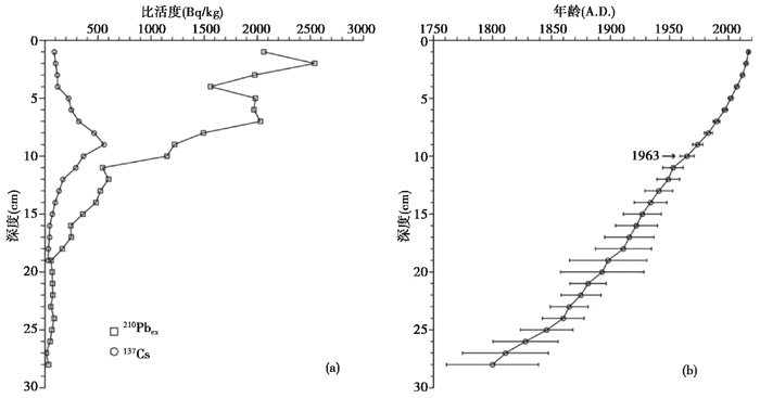
2 结果 2.1 泥炭剖面年代老里克泥炭地210Pbex比活度剖面变化显著,表层比活度高达2062.4 Bq/kg,向下逐渐波动下降,至28 cm降为35.5 Bq/kg(图 2a),基于210Pbex的CRS模型建立了剖面0~28 cm年代框架(图 2b)。剖面上137Cs比活度在9 cm达到峰值,为558.0 Bq/kg,对应全球的137Cs沉降高峰时期1963年,与210Pbex年龄可比较(图 2b)。4个AMS 14C测年结果见表 1。
|
图 2 (a) 老里克泥炭剖面210Pbex和137Cs比活度;(b)剖面年龄-深度模型 Fig. 2 (a)Specific activity of 210Pbex and 137Cs of Laolike peat profile; (b)Age-depth model of Laolike peat profile |
| 表 1 老里克泥炭地AMS 14C测年结果 Table 1 AMS 14C dating results of Laolike peatland |
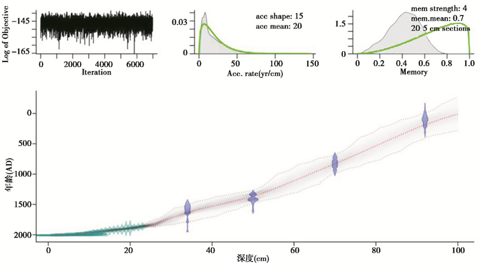
根据以上测年结果,基于Bacon模型[37],得到剖面的年龄框架(图 3),底部100 cm年龄为5 A.D.。该泥炭剖面记录了老里克泥炭地近2000年以来的环境变化历程。
|
图 3 老里克泥炭剖面年龄-深度模型 Fig. 3 Depth-age model of Laolike peat profile |
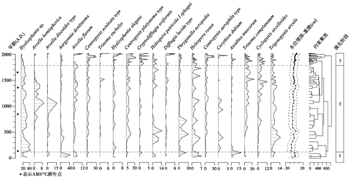
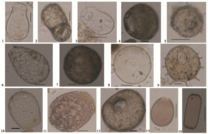
老里克泥炭地有壳变形虫剖面物种组成变化见图谱(图 4)。60个样品中观测有壳变形虫种类一共43种,总壳体数一共为9697个。主要种类包括茄壳虫(Hyalosphenia sp.)、片口匣壳虫(Centropyxis platystoma type)、平直三足虫(Trinema complanatum)、旋匣壳虫(Centropyxis aerophlia type)、顶足法冒虫(Phryganella acropodia)、齿口阿吉尼亚虫(Argynnia dentistoma)、小匣三角嘴虫(Trigonopyxis arcula)、盘状表壳虫(Arcella discoides type)、Archerella flavum、针棘匣壳虫(Centropyxis aculeata type)、附口/泥炭藓截口虫(Heleopera petricola/sphagni)、玫瑰截口虫(Heleopera rosea)、苔藓鳞盖虫(Assulina muscorum)、表壳圆壳虫(Cyclopyxis arcelloides)等(图 5)。
|
图 4 老里克泥炭剖面有壳变形虫图谱 仅列出丰度大于5 %的物种,水位埋深由ML模型获得,标准误差预测(standard error of prediction,简称SEP)用点划线表示出;根据约束聚类的结果,剖面水位变化划分3个阶段,用虚线表示;有壳变形虫从左到右是喜湿到喜干物种的分布 Fig. 4 Testate amoeba diagram for Laolike peat profile. Only the species with the most abundance over 5 % are listed. Depth to water table is obtained by the ML model with SEP (standard error of prediction) expressed in dotted lines. Water table changes of peat profile are divided into three phases, expressed in dotted lines according to the result of constrained clustering. Testate amoeba taxa are listed from left to right according to their hydrological preference from wet to dry |
|
图 5
老里克泥炭剖面的部分有壳变形虫物种照片
1.茄壳虫(Hyalosphenia sp.); 2.片口匣壳虫(Centropyxis platystoma type); 3.平直三足虫(Trinema complanatum); 4.旋匣壳虫(Centropyxis aerophlia type); 5.顶足法冒虫(Phryganella acropodia); 6.齿口阿吉尼亚虫(Argynnia dentistoma); 7.小匣三角嘴虫(Trigopyxis arcula); 8.盘状表壳虫(Arcell discoides type); 9.针棘匣壳虫(Centropyxis aculeata type); 10.附口/泥炭藓截口虫(Heleopera petricola/sphagni); 11.玫瑰截口虫(Heleopera rosea); 12.表壳圆壳虫(Cyclopyxis arcelloides); 13.苔藓鳞盖虫(Assulina muscorum); 14. Archerella flavum 图中比例尺代表 20 μm Fig. 5 Pictures of some testate amoebae from Laolike peat profile |
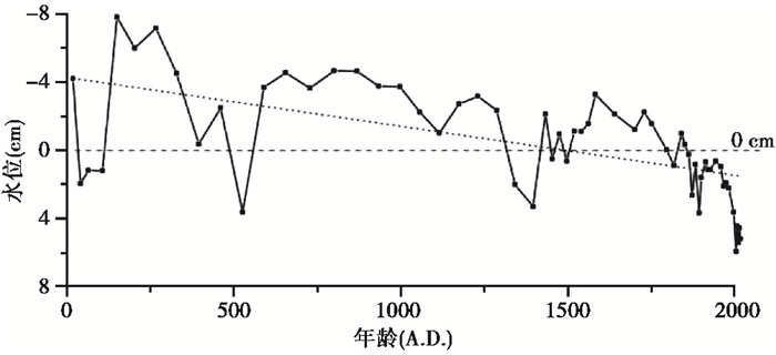
根据泥炭地剖面的物种组合,利用已建立的有壳变形虫-水位转换函数定量重建了老里克泥炭地古水位(图 6),并对重建的结果进行显著性检验。结果表明,3种模型定量重建的古水位变化趋势一致,WA、WAPLS模型未通过显著性检验,ML模型通过显著性检验(p=0.024)。因此,本文选择ML模型重建结果讨论泥炭地过去的水位变化。过去2000年以来老里克泥炭地水位埋深值在-7.8 cm(负值表示地表积水)至5.9 cm波动,表明泥炭水位一直保持在地表附近。从变化过程来看,5~150 A.D.间水位较低,之后在快速升至地表积水,1796 A.D.前泥炭地长期保持1~4 cm积水,期间526~591 A.D.、1342~1497 A.D.水位有所下降。长期来看,泥炭地水位有明显下降趋势,特别是1796 A.D.水位降至地表以下后,这种趋势更加显著。
|
图 6 老里克泥炭剖面水位变化 0 cm虚线代表地表;点线为水位变化线性拟合趋势 Fig. 6 Water table changes in Laolike peat profile. Dash line at 0 cm shows the surface of the peatland; Dotted line is the linear fit of water table changes |
基于210Pb/137Cs和AMS 14C定年方法建立老里克泥炭沉积剖面的年代框架,结合有壳变形虫物种组合和数量变化特征,根据约束聚类结果与重建的古水位,将该泥炭地过去2000以年来环境演变过程划分了3个阶段(图 4):
第一阶段:5~150 A.D.(100~91 cm),有壳变形虫以喜湿物种为主,如茄壳虫(H. sp.)、齿口阿吉尼亚(A.dentistoma)、A.flavum等;喜干物种如苔藓鳞盖(A.muscorum)、小匣三角嘴虫(T.arcula)等相对丰度较小。泥炭地水位自积水4.2 cm降至地表以下2.0 cm,并持续保持在1.2~2.0 cm之间。由于水位接近地表,泥炭地较湿润。
第二阶段:150~1796 A.D.(91~28 cm),喜湿的茄壳虫(H .sp.)、盘状表壳虫(A.discoides type)占优势。重建的水位显示泥炭地长期保持1~4 cm积水,少有波动,表明这阶段泥炭地非常湿润。但从长期看,积水深度呈明显波动下降趋势,最初积水有7.2 cm深,至末期积水降至0.4 cm深,526~591 A.D.、1342~1497 A.D.,水位甚至降低至地表以下。相应地,指示干燥的物种平直三足虫(T.complanatum)也呈逐渐增多的趋势。
第三阶段:1796~2017 A.D.(28~0 cm),中等湿润条件的针棘匣壳虫(C.aculeata type)、片口匣壳虫(C.platystoma type)占优势。喜湿的茄壳虫(H. sp.)显著减少,喜干的旋匣壳虫(C.aerophila type)增多。与前一阶段相比,水位下降趋势显著,水位埋深自0.2 cm降至5.2 cm。虽然水位已在地表以下,但仍接近地表,泥炭地仍比较湿润。
3 讨论从重建结果看(图 6),整个剖面老里克泥炭地水位高,波动的频率低、幅度也较小。这可能与老里克泥炭地发育的自然条件有关。该泥炭地位于甑峰岭分岭水顶部,海拔高,降水量大,加上浅洼地形,利于汇水,使泥炭地长期保持相对湿润,特别是夏季,常普遍积水。因此,一些史料文献记录其为“季节性湖泊”[38]。这样的地形、气候条件使得过去2000年,老里克泥炭地一直保持比较稳定的湿润状态,水分条件不曾成为有壳变形虫生长的限制因子,一直以喜湿占优势,降低了有壳变形虫对水位变化响应的敏感性。
泥炭地的水位变化可由多种因素导致。一方面,泥炭地的内生过程,特别是泥炭累积,使泥炭地地表抬升,水位逐渐降低,这也是水体沼泽化的主要过程;另一方面,气候变化也可导致泥炭地水位波动。当降水增多,或气温降低导致蒸散减弱,抑或两者共同变化,可以造成泥炭地变湿,水位升高;反之,水位下降。
3.1 老里克泥炭地古水位变化的内部驱动力过去2000年老里克泥炭地一直湿润,大部分时间里地表保持积水,但积水深度持续下降,水位总体呈下降趋势。这很可能与泥炭的不断累积有关。在水体沼泽化过程中,由于水分充足,适宜的温度和光照条件下,泥炭地的生物量非常大。地处中高纬度的温带、寒温带冬季寒冷漫长、加上泥炭地的还原条件,植物残体分解缓慢,泥炭积累旺盛[39]。大量的泥炭积累导致地表逐渐抬升,水位相对下降。这种内生长过程持续发展,地表植物最终会脱离地表径流和地下径流的直接影响,其水分和养分补给主要靠大气降水,矿养型泥炭地演替为雨养型泥炭地[40]。老里克泥炭地目前仍处在矿养型向雨养型发育过程中。内生过程的影响持续发挥作用,使水位逐渐下降。这种现象在国内外的其他研究中也有报道[41~45]。
3.2 老里克泥炭地古水位变化的气候驱动因子尽管理论上不难理解气温和降水的变化都会影响泥炭地水位,但到底哪个因素是主导因素,现有的研究结论不一致。欧洲的一些研究表明,夏季降水是影响泥炭地水位变化的主要因素,而随着气候大陆度增加,温度的影响逐渐增大[16, 46];另一方面,有的研究则发现温度是水位变化主要影响因素[21, 47]。Charman等[48]根据西北欧的研究认为泥炭地水位变化主要由降水的驱动,而与降水负相关的温度变化加强了水位变化的幅度;Booth[49]根据北美的研究发现温度与降水对泥炭地水位影响相对重要性存在明显的时间和空间变化。
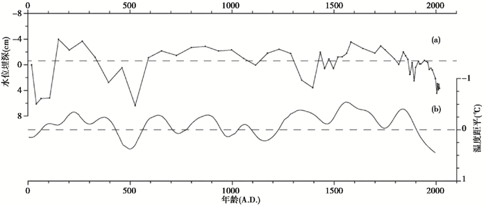
为了讨论老里克泥炭地水位与气候变化的关系,我们首先利用一元线性回归,尝试拟合内生过程对水位变化的影响(图 6),再从总的水位变化中减去内生过程的影响,得到的水位波动(图 7a)则被认为是气候变化的影响。Ge等[50]根据已发表的成果,进行了过去2000年的温度集成研究。我们选择其中东北地区的温度集成结果(图 7b)作为参考,讨论老里克泥炭地波动对气温变化的响应关系。
|
图 7 过去2000年老里克泥炭地水位埋深波动(a)与东北地区气温变化(b)对比 水位波动去除了内生过程的影响,东北地区气温变化曲线根据文献[50]绘制 Fig. 7 Comparison between depth to water table changes of Laolike peatland (a) and temperature changes of NE China during the last 2000 years. The influence of autogenesis process was removed by linear fitting for water changes. The line of temperature changes of NE China was redrawn according to reference [50] |
对比发现,过去2000年来老里克泥炭地的水位波动与气温变化趋势表现出很好的反相位对应。在暖期时,气温升高,泥炭地蒸发量增大,植物蒸腾显著增加,总蒸散量的增大会导致水位下降;相反,冷期时泥炭地水位升高。考虑到气温与降水的组合,气候对泥炭地水位的影响实际上要更加复杂。如果暖期降水减少,冷期降水增加,暖干/冷湿组合会加强上述对应关系(5~600 A.D.,1500~2000 A.D.);相反,暖期降水增多,冷期降水减少,降水的变化会抵消、甚至超过温度变化的影响,上述温度与水位的对应关系会在一些时段被削弱、甚至反转(1050~1430 A.D.)。
国内外的研究均表明,泥炭地水位与气候的关系不能用温度或降水单一指标解释,而需要能综合反映二者变化的指标[19, 48~49]。例如Charman等[48]提出的夏季水分亏缺(summer moisture deficit)指标,Booth[49]提出的帕默尔干旱指数(Palmer Drought Severity Index)等。未来,还需要更多有精确定年的高分辨率的泥炭地古水位、古温度、古降水记录来验证这些指标的有效性。
4 结论(1) 基于210Pb/137Cs和AMS 14C测年结果,运用Bacon模型建立了老里克泥炭地年代框架,测得底部100 cm年龄为5A.D.。
(2) 累计观察有壳变形虫43种,主要包括茄壳虫(H. sp.)、片口匣壳虫(C.platystoma type)、平直三足虫(T.complanatum)、旋匣壳虫(C.aerophlia type)、顶足法冒虫(P.acropodia)、齿口阿吉尼亚虫(A.dentistoma)、小匣三角嘴虫(T.arcula)、盘状表壳虫(A.discoides type)、A.flavum、针棘匣壳虫(C.aculeata type)、附口/泥炭藓截口虫(H.petricola/sphagni)、玫瑰截口虫(H.rosea)、苔藓鳞盖虫(A.muscorum)、表壳圆壳虫(C.arcelloides)等。
(3) 重建的古水位表明,老里克泥炭地过去2000年以来一直保持湿润状态,经历了比较湿润→非常湿润→比较湿润的波动变化,根据有壳变形虫物种组合与水位变化,可划3个阶段:1)5~150 A.D.(100~91 cm)泥炭地比较湿润,有壳变形虫主要以喜湿物种为主,喜干物种较少,水位埋深保持在1.2~2.0 cm;2)150~1796 A.D.(91~28 cm)泥炭地非常湿润,地表长期保持1~4 cm积水,但积水深度不断变浅;3)1796~2017 A.D.(28~0 cm),泥炭地虽较前阶段已显著变干,但仍比较湿润,水位埋深自0.2 cm持续降至5.2 cm,适合中等湿润条件有壳变形虫物种占优势。
(4) 老里克泥炭地的水位变化受内生过程和气候变化共同影响。2000年以来持续变干的趋势,可能主要受内生过程影响,由于泥炭不断累积,泥炭地表抬升,水位相对下降。去除内生过程影响后,泥炭地水位波动整体上与温度变化表现出很好的反相位对应,温度升高,泥炭地水位下降。但不同阶段气温/降水组合的差异会加强或削弱这种关系。
致谢: 非常感谢审稿专家和编辑部杨美芳老师建设性的修改意见!感谢东北师范大学地理科学学院李楠楠博士为英文摘要提出修改建议!
| [1] |
孔锋, 王一飞, 吕丽莉.全球气候变暖停滞争论下的中国气候变暖诊断分析[C]//中国会议: 第35届中国气象学会年会S7东亚气候、极端气候事件变异机理及气候预测, 2018. Kong Feng, Wang Yifei, Lu Lili. Diagnosis and analysis of China's climate warming in the context of global warming stagnation debate[C]//China Conference: The 35th Annual Meeting of the Chinese Meteorological Society S7 East Asian Climate and Extreme Climate Event Variation Mechanism and Climate Prediction, 2018. |
| [2] |
苏倩倩, 朱单, 何奕忻, 等. 若尔盖高原花湖泥炭沉积及其对气候变化的响应[J]. 中国科学院大学学报, 2017, 34(4): 478-486. Su Qianqian, Zhu Dan, He Yixin, et al. Peat sedimentation and its response to climate change of Huahu peatland on Zoigê Plateau[J]. Journal of University of Chinese Academy of Sciences, 2017, 34(4): 478-486. |
| [3] |
鹿化煜, 安芷生. 黄土高原黄土粒度组成的古气候意义[J]. 中国科学(D辑), 1998, 28(3): 278-283. Lu Huayu, An Zhisheng. The paleoclimate significance of the grain size of loess in Chinese Loess Plateau[J]. Science in China(Series D), 1998, 28(3): 278-283. |
| [4] |
Bradley R S. Paleoclimatology:Reconstructing Climates of the Quaternary[M]. New York: Academic Press, 2001: 1-9.
|
| [5] |
Martanez C A, Garcia-Rodeja G E, Weiss D. Peat bog archives of atmospheric metal deposition[J]. Science of the Total Environment, 2002, 292(1-2): 1-5. DOI:10.1016/S0048-9697(02)00024-4 |
| [6] |
Charman D. Peatlands and Environmental Change[M]. Chichester: John Wiley, 2002: 117-203.
|
| [7] |
Chambers F M, Booth R K, De Vleeschouwer F, et al. Development and refinement of proxy-climate indicators from peats[J]. Quaternary International, 2012, 268(3): 21-33. |
| [8] |
孙晓红, 赵艳, 李泉. 青藏高原东部若尔盖盆地全新世泥炭地发育和植被变化[J]. 中国科学:地球科学, 2017, 47(9): 1097-1109. Sun Xiaohong, Zhao Yan, Li Quan. Holocene peatland development and vegetation changes in the Zoigê Basin, eastern Tibetan Plateau[J]. Science China:Earth Sciences, 2017, 47(9): 1097-1109. |
| [9] |
李泉, 赵艳. 青藏高原东部若尔盖盆地泥炭发育记录的全新世气候突变[J]. 第四纪研究, 2019, 39(6): 1323-1332. Li Quan, Zhao Yan. Abrupt climatic changes in the Holocene recorded by the history of peat formation in Zoigé Basin on the eastern Tibetan Plateau[J]. Quaternary Sciences, 2019, 39(6): 1323-1332. |
| [10] |
李凯, 金伊丽, 谭斌, 等. 浙江景宁县大仰湖沼泽泥炭地形成过程及气候背景[J]. 第四纪研究, 2019, 39(6): 1384-1392. Li Kai, Jin Yili, Tan Bin, et al. Development and climatic background of Dayanghu marsh peat from Jingning County, Zhejiang Province[J]. Quaternary Sciences, 2019, 39(6): 1384-1392. |
| [11] |
秦养民, 谢树成, 顾延生, 等. 第四纪环境重建的良好代用指标——有壳变形虫记录与古生态学研究进展[J]. 地球科学进展, 2008, 8(23): 803-812. Qin Yangmin, Xie Shucheng, Gu Yansheng, et al. An excellent indicator for Quaternary paleoenvironmental reconstructions-Advances in the study of testate amoebae[J]. Advances in Earth Science, 2008, 8(23): 803-812. |
| [12] |
Charman D J, Warner B G. Relationship between testate amoebae(Protozoa:Rhizopoda)and microenvironmental parameters on a forested peatland in northeastern Ontario[J]. Canadian Journal of Zoology, 1992, 70(12): 2474-2482. DOI:10.1139/z92-331 |
| [13] |
Charman D J, Hendon D, Woodland W A. The Identification of Testate Amoebae(Protozoa:Rhizopoda)in Peats:Quaternary Research Association Technical Guide No.9[J]. London:Quaternary Research Association, 2000, 1-147. |
| [14] |
秦养民, 巩静, 顾延生, 等. 鄂西亚高山泥炭地有壳变形虫生态监测及对水位的指示意义[J]. 地球科学, 2018, 43(11): 4036-4045. Qin Yangmin, Gong Jing, Gu Yansheng, et al. Ecological monitoring and environmental significance of testate amoebae in subalpine peatlands in West Hubei Province, China[J]. Earth Science, 2018, 43(11): 4036-4045. |
| [15] |
Lamarre A, Magnan G, Garneau M, et al. A testate amoeba-based transfer function for paleohydrological reconstruction from boreal and subarctic peatlands in Northeastern Canada[J]. Quaternary International, 2013, 306: 88-96. DOI:10.1016/j.quaint.2013.05.054 |
| [16] |
Charman D J. Summer water table deficit variability control on peatland water table changes:Implications for Holocene palaeoclimate reconstructions[J]. The Holocene, 2007, 17(2): 217-227. DOI:10.1177/0959683607075836 |
| [17] |
李鸿凯, 李微微, 蒲有宝, 等. 应用rioja软件包建立有壳变形虫-环境因子转换函数[J]. 地理科学, 2013, 8(33): 1022-1028. Li Hongkai, Li Weiwei, Pu Youbao, et al. Building transfer functions between testate amoeba and environmental variables with 'rioja' package[J]. Geographical Science, 2013, 8(33): 1022-1028. |
| [18] |
秦养民, 谢树成.长江中游高山泥炭湿地有壳变形虫生态学与水位转换函数[C]//中国古生物学会第26届学术年会, 2011. Qin Yangmin, Xie Shucheng. Testate amoebae ecology and a water table transfer function of from alpine peatlands in the middle reaches of Yangtze River[C]//The 26th Annual Conference of the Chinese Society of Palaeontology, 2011. |
| [19] |
李帅, 李鸿凯, 王升忠, 等. 基于有壳变形虫的大兴安岭洛古河泥炭沼泽古水位定量重建[J]. 第四纪研究, 2017, 37(6): 1403-1411. Li Shuai, Li Hongkai, Wang Shengzhong, et al. The quantitative reconstruction of the paleo-water table of Luoguhe peatland in Daxing' anling Mountains based on testate amoebae assemblages[J]. Quaternary Sciences, 2017, 37(6): 1403-1411. |
| [20] |
鲍锟山, 邢伟, 宋理洪, 等. 黑龙江流域湿地过去百年水位变化历史及驱动机制[J]. 第四纪研究, 2018, 38(4): 981-995. Bao Kunshan, Xing Wei, Song Lihong, et al. A 100-year history of water level change and driving mechanism in Heilongjiang River basin wetlands[J]. Quaternary Sciences, 2018, 38(4): 981-995. |
| [21] |
Schoning K, Charman D J, Wastegaård S. Reconstructed water tables from two ombrotrophic mires in eastern central Sweden compared with instrumental meteorological data[J]. The Holocene, 2005, 15(1): 111-118. DOI:10.1191/0959683605hl772rp |
| [22] |
Payne R J, Kishaba K, Blackford J J, et al. Ecology of testate amoebae(Protista)in south-central Alaska peatlands:Building transfer-function models for palaeoenvironmental studies[J]. Journal of Quaternary Science, 2006, 16(3): 403-414. |
| [23] |
Wilmshurst J M, Wiser S K, Charman D J. Reconstructing Holocene water tables in New Zealand using testate amoebae:Differential preservation of tests and implications for the use of transfer functions[J]. The Holocene, 2003, 13(1): 61-72. DOI:10.1191/0959683603hl595rp |
| [24] |
Swindles G T, Reczuga M, Lamemtowicz M, et al. Ecology of testate amoebae in an Amazonian peatland and development transfer function for palaeohydrological reconstruction[J]. Microbial Ecology, 2014, 68(2): 284-298. DOI:10.1007/s00248-014-0378-5 |
| [25] |
Li Hongkai, Wang Shengzhong, Zhao Hongyan, et al. A testate amoebae transfer function from Sphagnum-dominated peatlands in the Lesser Khingan Mountains, NE China[J]. Journal of Paleolimnology, 2015, 54(2-3): 189-203. DOI:10.1007/s10933-015-9846-2 |
| [26] |
赵长跃, 王文利, 吕惠子. 老里克湖植物多样性[J]. 湿地科学, 2017, 15(5): 713-715. Zhao Changyue, Wang Wenli, Lü Huizi. Vegetation diversity of Laolike Lake[J]. Wetland Science, 2017, 15(5): 713-715. |
| [27] |
Booth R K, Lamentowicz M C, Charman D J. Reparation and analysis of testate amoebea in peatland palaoenvironment studies[J]. Mire & Peat, 2010, 7(2): 1-7. |
| [28] |
Appleby P G. Chronostratigraphic techniques in recent sediments[M]//Last W M, Smol J P eds. Tracking Environmental Change Using Lake Sediments Volume 1: Basin Analysis, Coring and Chrological Technique. Dordrecht, The Netherlands: Kluwer Academic Publishers, 2001: 171-203.
|
| [29] |
R Development Core Team. R: A Language and Environment for Statistical Computing[CP]. 2019. https://www.r-project.org.
|
| [30] |
Blaauw Maarten, Christen J Andres. rbacon: Age-Depth Modelling using Bayesian Statistics[CP]. 2019. https://CRAN.R-project.org/package=rbacon.
|
| [31] |
Telford R J, Birks H J B. A novel method for assessing the statistical significance of quantitative reconstructions inferred from biotic assemblages[J]. Quaternary Science Reviews, 2011, 30(9-10): 1272-1278. DOI:10.1016/j.quascirev.2011.03.002 |
| [32] |
Payne R J, Babeshko K V, van Bellen S, et al. Significance testing testate amoeba water table reconstructions[J]. Quaternary Science Reviews, 2016, 138: 131-135. DOI:10.1016/j.quascirev.2016.01.030 |
| [33] |
Grimm E C. CONISS:A FORTRAN 77 program for stratigraphically constrained cluster analysis by the method of incremental sum of squares[J]. Computers & Geosciences, 1987, 13(1): 13-35. |
| [34] |
Bennett K D. Determination of the number of zones in a biostratigraphical sequence[J]. New Phytologist, 1996, 132(1): 155-170. DOI:10.1111/j.1469-8137.1996.tb04521.x |
| [35] |
Juggins S. Rioja: Analysis of Quaternary Science Data[CP]. 2017. https://CRAN.R-project.org/package=rioja.
|
| [36] |
Telford R J, Trachsel M.PalaeoSig: Significance Tests of quantitative Palaeoenvironmental Reconstructions[CP]. 2015. https://CRAN.R-project.org/package=palaeoSig.
|
| [37] |
Blaauw M, Christen J A. Flexible paleoclimate age-depth models using an autoregressive gamma process[J]. Bayesian Analysis, 2011, 6(6): 457-474. |
| [38] |
赵景洲, 于伟. 老里克湖略考[J]. 吉林水利, 1995, 10(10): 46. Zhao Jingzhou, Yu Wei. A Brief study of Laolike Lake[J]. Jilin Water Resources, 1995, 10: 46. DOI:10.15920/j.cnki.22-1179/tv.1995.10.016 |
| [39] |
Charman D J, Beilman D W, Blaauw M, et al. Climate-related changes in peatland carbon accumulation during the last millennium[J]. Biogeosciences, 2013, 10(2): 929-944. DOI:10.5194/bg-10-929-2013 |
| [40] |
Rydin H, John J. The biology of peatlands[M]. Oxford: Oxford University Press, 2006: 119-137.
|
| [41] |
张彦, 马学慧, 刘兴土, 等. 新疆阿尔泰山区全新世泥炭丘形态、发育过程与泥炭堆积速率初探[J]. 第四纪研究, 2018, 38(5): 1221-1232. Zhang Yan, Ma Xuehui, Liu Xingtu, et al. Priliminary study on morphology, development process and peat accumulation rate of palsas during the Holocene in the Altai Mountains, northern Xinjiang Autonomous Region, Northwest China[J]. Quaternary Sciences, 2018, 38(5): 1221-1232. |
| [42] |
Yu Z, Vitt D H, Campbell D I, et al. Understanding Holocene peat accumulation pattern of continental fens in Western Canada[J]. Canadian Journal Botany, 2003, 81(3): 267-282. DOI:10.1139/b03-016 |
| [43] |
Siegel D I, Reeve A S, Glaser P H, et al. Climate-driven flushing of pore water in peatlands[J]. Nature, 1995, 374(6522): 531-533. DOI:10.1038/374531a0 |
| [44] |
Kuhry P, Vitt D H. Fossils carbon/nitrogen ratios as a measure of peat decomposition[J]. Ecology, 1996, 77: 271-275. DOI:10.2307/2265676 |
| [45] |
Glaser P H, Siegel D I, Romanowicz E A, et al. Regional linkages between raised bogs and the climate, groundwater, and landscape of north-western Minnesota[J]. Journal of Ecology, 1997, 85(1): 3-16. |
| [46] |
Charman D J, Brown A D, Hendon D, et al. Testing the relationship between Holocene peatland palaeoclimate reconstructions and instrumental data at two European sites[J]. Quaternary Science Reviews, 2004, 23(1-2): 137-143. DOI:10.1016/j.quascirev.2003.10.006 |
| [47] |
Hendon D, Charman D J. High-resolution peatland water-table changes for the past 200 years:The influence of climate and implications for management[J]. The Holocene, 2004, 14(1): 125-134. DOI:10.1191/0959683604hl695rp |
| [48] |
Charman D J, Barber K E, Blaauw M, et al. Climate drivers for peatland palaeoclimate records[J]. Quaternary Science Reviews, 2009, 28(19-20): 1811-1819. DOI:10.1016/j.quascirev.2009.05.013 |
| [49] |
Booth R K. Testing the climate sensitivity of peat-based paleoclimate reconstructions in mid-continental North America[J]. Quaternary Science Reviews, 2010, 29(5-6): 720-731. DOI:10.1016/j.quascirev.2009.11.018 |
| [50] |
Ge Q, Hao Z, Zheng J, et al. Temperature changes over the past 2000 yr in China and comparison with the Northern Hemisphere[J]. Climate of the Past, 2013, 9(3): 1153-1160. DOI:10.5194/cp-9-1153-2013 |
2 Key Laboratory of Geographical Process and Ecological Safety of Baishan, Minister of Education, Changchun 130024 Jilin;
3 National Key Laboratory of Environmental Wetland Ecology and Vegetation Restoration, Changchun 130024 Jilin)
Abstract
Water table is one of the key factors that controlling the peatland initiation and development, and therefore has attracted a lot of attentions in the field of peatland paleoenvironment reconstruction. In this study, a 100-cm peat core was sampled from the Laolike peatland (42°28'49.75"N, 128°39'9.02"E; 1470 m a. s. l.) in the Changbai Mountains. The chronological model was established using radioactive nuclides dating methods, namely 210Pb/137Cs and AMS14C dating. Based on testate amoebae data, the peatland water table variations were quantitatively reconstructed using a transfer function. The results show that the water table in the Laolike peatland is relative higher in general but still experienced three different stages, during the past 2000 years. According to the constrained clustering results, the three water table change stages were identified from the testate amoebae assemblages. (1) 5~150 A.D. (100~91 cm), the peatland water table was relative high and the testate amoebae were dominated by species that preferring higher water table, such as Hyalosphenia sp., Argynnia dentistoma, and Archerella flavum, whereas the species that inhabit in relative dry environments, such as Assulina muscorum and Trigonopyxis arcula were less than the other stage. During this stage, the depth to water table (DWT) varied from 1.2 cm to 2.0 cm. (2) 150~1796 A.D. (91~28 cm), the water table was much higher than previous stage, with 1~4 cm standing water above the peatland surface for a long time, although the general trend of water table is decreasing. The dominant testate amoebae species were H. sp., Arcella discoides type. (3) 1796~2017 A.D. (28 cm~0), the peatland water table fell significantly compared with the previous stages. The DWT gradually increased from 0.2 cm to 5.2 cm, indicating a decrease in peatland water table. Species that prefer moderately wet conditions, such as Centropyxis aculeata type, Centropyxis platystoma type, were dominant, while the percentange of H. sp. showed a decreasing trend dramatically. Our results suggest that the water table variations of the Laolike peatland was influenced by both peatland-specific factors and external forcing, especially regional climate change. 2020, Vol.40

