 2020, Vol.40

2 南方海洋科学与工程广东省实验室(珠海), 广东 珠海 519080;
3 广东省地质过程与矿产资源探查重点实验室, 广东 广州 510275)
土壤是人类赖以生存和发展的基础自然资源之一[1]。土壤发生实质是上地壳元素的迁移及其重新组合,这一过程受母岩、地貌、气候、水文和植被等诸多要素的影响和控制[2~6],同时土壤的理化性质制约着地球生态系统各组成要素的运行与演化[7~8],因此,土壤机械组成和元素特征常被国内外学者用作古气候、古环境变化研究的代用指标[9~19]。表层土壤与大气、植被和径流之间的物质交换十分活跃,在地球表层生物地球化学循环中处于关键地位,其理化性质影响地表环境质量。例如,表土机械组成通过影响土壤的抗侵蚀能力、土壤肥力特征[20]和降水入渗特征进而影响植物生长[21];表土化学组成影响流域土壤资源、水资源和农产品质量[20~21]。截至目前,对水土流失较强、水资源强烈开发的流域表土机械组成和地球化学特征的研究较少,对干热河谷表土化学风化过程及影响因素的定量研究尚未见报道。
雅砻江下游流域位于青藏高原与四川盆地的过渡地带,地壳运动活跃,岩石组成复杂,山地谷坡的坡度较大,水土流失严重,生态环境脆弱[22~24]。本研究选择并采集雅砻江下游流域内具有代表性的地貌部位和植物群落表层土壤样品,分析其元素和机械组成,运用粒度参数、地球化学参数、相关分析和岭回归分析(ridge regression)等指标和方法,探讨雅砻江下游干热河谷表土机械组成和元素组成的空间异质性,揭示干热河谷地区土壤矿物风化的程度和演化趋势及主要控制因素,并定量估算主要影响因素对表土风化程度的贡献。本研究可为深入探讨干热河谷地区土壤生物地球化学过程提供基础数据。
1 研究区概况雅砻江流域地处青藏高原东南缘、横断山脉干热河谷北段(26°32′~34°05′N,96°52′~102°48′E),流域面积约13.6×10⁴ km2,干流全长1571 km,尼拖以上为上游,尼拖-理塘河口为中游,理塘河口以下为下游。雅砻江下游水力资源丰富,干流上已经建成锦屏一级、锦屏二级、官地、二滩和桐子林5座大坝。流域内地质构造复杂,岩性多样,干流及其以西地区属雅砻江断裂带,为一系列NNE向断层分割的断块,出露下古生界及上古生界碳酸盐岩类、浅变质岩类、砂页岩和砾岩;东部安宁河地区主要由前震旦系花岗片麻岩及变质岩类构成台背斜基底,周围有部分志留系、泥盆系砂板岩、石灰岩及侏罗系砂页岩,安宁河谷断裂带属川滇南北断裂带的主干,大部分地区地震烈度为6~7度[25]。下游干流为中高山峡谷,支流有宽谷、盆地出现。
研究区气候主要受西南季风和高空西风环流影响[26],干湿季分明,11月至翌年4月为干季,5月至10月为雨季,年降水量900~1300 mm。雅砻江下游深切河谷在西南季风、山谷风和焚风效应的影响下,山地气候的垂直地带性显著:河谷区属于亚热带气候,长夏无冬,降水量少而蒸发量大;高山区则为寒温带气候,昼夜温差大,降雨量集中[22~23]。研究区基带属亚热带偏干性常绿阔叶林亚带,受水、热等条件的影响,植被亦具有垂直地带性:谷底亚热带草地、灌丛等旱生植物占优势,随海拔升高植被覆盖率增大,依次出现高山栎林、松栎混交林、亚高山常绿针叶林(图 1)。研究区内植被以自然植被为主,约占总面积的85 %;农作物约占总面积的15 %,主要有玉米、水稻、马铃薯、荞麦等粮食作物和芒果、核桃、油桐、苹果以及花椒等经济作物[27](图 1)。研究区内分布较广的土壤类型有暗棕壤(dark brown soil)、棕壤(brown soil)和红壤(red soil)。

|
图 1 研究区植被类型和采样点位置(植被数据源自文献[27]) Fig. 1 Vegetation types and distribution of sampling sites in the study area. Vegetation data from reference[27] |
考虑研究区复杂且破碎的岩石组成、山高坡陡的地貌特征、显著的气候垂直地带性、多样化的植被类型和土地利用方式等条件,分别于2018年1月和2018年7月在研究区海拔1000~3000 m的谷坡、山间宽谷坡地和山间断陷盆地选择草地(ZR)、稀树灌丛草地(TZL)、杂木林地(ETL)、合欢林地(JHQ)、针阔混交林(ZKL)、云南松林(SL)、宽谷草地(CD)、玉米地(YM)、芒果园(MG)、苹果园(PG)等10个样地。其中ZKL、SL、CD和PG样地位于研究区西部雅砻江一级支流理塘河流域坡地和宽谷地,发育于沉积岩或第四纪沉积物上,海拔>2400 m、坡度较缓;样地JHQ、ZR、TZL、ETL、YM和MG位于雅砻江下游干流谷坡,海拔<1300 m、坡度较大,其中TZL、YM和MG样地的母岩为火成岩,ZR、ETL和JHQ样地的母岩为沉积岩。由于所选样地除SL、CD外,其余样地土壤层厚度均在10 cm左右,为便于比较,每个样地按“V”字形采集3个表层土壤(0~10 cm)样品,各样点间距大于20 m,共采集表土样品30个。各样地的地理位置和海拔高度由GPS现场测定。样地位置和详情见图 1和表 1。
| 表 1 样地特征 Table 1 Characters of 10 community plots |
样品运回实验室后,土壤含水量用烘干法测量。将风干的土壤样品过筛(2 mm),用1 mol/L的盐酸去除土样中的碳酸盐后,使用元素分析仪(Vario EL cube,德国Elementar)测定土壤有机碳(SOC)和全氮(TN)含量。用30 %的双氧水(H2O2)去除有机质,1 mol/L的盐酸去除碳酸盐,使用激光粒度仪(Mastersizer 2000,英国Malvern)测定土壤粒径组成。取风干样品用玛瑙研钵充分碾磨并过200目筛,取2~3 g过筛样品,用四硼酸锂(Li2B4O7)作熔融剂,溴化锂(LiBr)作脱离剂,在XRF专用坩埚内1150 ℃将样品彻底熔化后制成片状,最后使用X射线荧光光谱仪(ZSX primus,日本Rigaku)测定样品元素含量,测量精度0.01 %。
由于操作失误,PG样地的样品未进行元素组成分析。因此,文中元素组成及相关分析(元素氧化物含量、CIA值、Na/K比值)使用的数据共计27组;粒度、SOC、TN等分析项目数据均为30个。
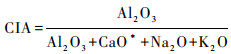
2.3 数据处理应用粒度图解法(频率曲线图、累积频率曲线图)和粒度参数(平均粒径(Mz)、中值粒径(ϕ50))[28]揭示研究区表土质地及其记载的化学风化特征;使用化学蚀变指数(chemical index of alteration,简称CIA)[29]、A-CN-K(即Al2O3-(CaO*+Na2O)-K2O)三角图解[30]和Na/K比值[31~32]指示化学风化强度。其中CIA值计算公式为:
|
(1) |
公式(1)中,等式右边各项指标均为氧化物摩尔分数;CaO*指硅酸盐矿物中的CaO。根据硅酸盐矿物中CaO与Na2O通常以1:1的比例存在,McLennan[33]提出:在不明确碳酸盐含量的情况下,当CaO的摩尔分数大于Na2O时,可以认为CaO*=Na2O,反之则认为CaO*=CaO。
坡度和坡向由DEM数据提取(ASTER GDEM 30 m分辨率,数据源自中国科学院计算机网络信息中心地理空间数据云平台(http://www.gscloud.cn));运用SPSS Statistics 19.0对测量数据进行统计分析。为消除影响矿物化学风化过程的共线性因素,采用岭回归分析探讨各主要影响因素对研究区表土化学风化的定量贡献。文中图件运用ArcGIS 10.5和Origin 2018b绘制。
3 结果与讨论 3.1 土壤粒度特征及其意义根据美国制土壤粒级划分标准,将研究区表土粒度组成划分为粘粒(<2 μm)、粉砂(2~50 μm)和砂粒(>50 μm)共3组,各粒级的平均含量分别为19.28 %、46.68 %和34.05 %。研究区表土粘粒含量显著高于以粉砂组分为主的黄土的相应值(12.40 %(黄土高原)、14.16 %(秦岭)、4.13 %(川西高原))[34~35]。
研究区表土粒度频率曲线呈多峰型曲线(图 2a),揭示其表土机械组成存在多成因组分,可能包含原地风化形成的颗粒和流体搬运沉积的颗粒。南部桐子林水库库周坡地的草地(ZR)、稀树草地(TZL)和农业用地(MG和YM)样地表土粒度频率曲线峰值均明显右移,最高峰值出现在200~600 μm之间,指示土壤粘粒<粉砂<砂粒;随海拔升高,二滩水库库周坡地ETL样地表土粒度频率曲线峰值虽明显右移,但频率曲线峰较为平缓,且两个峰的高度相近,分别出现在30 μm和350 μm附近,指示粉砂与砂粒含量相近;位于研究区中部、二滩水库库尾坡地的阔叶林样地(JHQ)的粒度频率曲线峰值左移至6~10 μm处,粉砂含量高于砂粒;海拔2400 m以上的PG、SL、CD和ZKL样地表土粒度频率曲线峰值显著左移(以ZKL样地最为突出),揭示研究区西北部海拔较高、坡度较缓的样地表土粘粒组分占优势,砂粒含量较低。累积频率曲线(图 2b)亦揭示PG、SL、CD和ZKL样地的表土粒径在0.2 μm处频率密度最大,其余样地的曲线斜率则在粒径较大处开始增大。

|
图 2 土壤颗粒频率分布与累积频率分布曲线 (a)土壤颗粒频率分布曲线;(b)土壤颗粒累积频率分布曲线 Fig. 2 Frequency distribution and cumulative frequency distribution curve of soil particles. (a)Frequency distribution curve of soil particles; (b)Cumulative frequency distribution curve of soil particles |
粒度参数能够有效地指示沉积物或土壤的粒度分布特征[28, 36~37],平均粒径(Mz)指示粒径频率分布的中心趋向,中值粒径(ϕ50)指示粒径频率分布的中位数[38],研究区表土Mz的平均值为6.02ϕ。海拔较低的ZR、TZL和MG样地Mz值在3.94~4.33ϕ之间,平均值为4.08ϕ,表明土壤粒径较粗;随着海拔升高,YM、ETL和JHQ样地Mz增大至4.70~6.35ϕ之间,平均值为5.34ϕ;海拔>2400 m的PG、SL、CD和ZKL样地Mz变化于7.91~8.57ϕ之间,平均值为8.15ϕ,指示其表土质地细粒组分占优势。研究区表土ϕ50变化范围在3.69~8.22ϕ之间,平均值为5.83ϕ,其中西部的PG、SL、CD和ZKL样地ϕ50在7.46~8.23ϕ之间,中部和南部样地(ZR、TZL、YM、MG、ETL、JHQ)样地的ϕ50在3.69~6.63ϕ之间。可见,研究区表土ϕ50与Mz的变化趋势基本一致,且数值相差较小。
研究区不同群落表土各粒级组分的变化幅度有差异。砂粒和粉砂组分含量变异系数较小(分别为0.55和0.21);粘粒含量变化于1.44 %~48.32 %之间,其中,海拔较低(<1300 m)、坡度较大的谷坡草地、稀树草地和林地表土平均粘粒含量仅为6.51 %,而海拔较高(>2400 m)的缓坡宽谷盆地草地、松林和混交林地粘粒含量高达39.21 %。可见,研究区表土粘粒含量变异系数较大(0.93),揭示研究区不同地貌部位表土质地具有明显的空间异质性:海拔较低的南部表土砂粒含量较高,海拔较高的西北部表土粘粒含量较高。土壤粘粒(粘土矿物)是土壤原生矿物化学风化的产物,其形成一方面受制于母岩风化抗蚀性[39~40],另一方面受地貌部位制约,地貌部位对水热条件的再分配改变了水-岩接触时间直接影响岩石和土壤矿物的风化。南部样地均位于谷坡中下部、坡度较陡处,坡面径流流速快,水与矿物接触时间短,化学风化成壤作用强度较弱,同时其表土受到强烈的流水侵蚀[41],细颗粒物质难以保留。西部样地多位于坡度较缓的山间宽谷盆地,水与矿物有相对充足的接触反应时间,所以其表土化学风化成壤作用较强烈[23, 42],且由于植被覆盖度高,土壤侵蚀程度较轻[41, 43],粘粒组分得以长期留存。研究区表土粘粒含量的显著差异亦揭示不同地貌部位表土处于不同的发育和演化阶段,且土壤颗粒在区域外营力的作用下可能发生了不同程度的横向与垂向迁移。
土壤粘粒(粘土矿物)构成土壤胶体的主体,因其具有巨大的比表面积和表面能,通过与土壤固相、液相和气相中的离子相互作用,影响土壤物理、化学、生物学过程以及生态环境功能[44],进而制约区域生态农业的发展。
3.2 矿质元素分布特征土壤中矿质元素的组成与变化可以反映土壤的风化程度,也可用于判断土壤粘土矿物的主要类型[45]。研究区表土矿质元素组成(以氧化物计)以SiO2(50.28 %)、Al2O3(16.97 %)和Fe2O3(9.78 %)为主;其次为CaO(3.22 %)、MgO(2.62 %)、K2O(1.65 %)、TiO2(1.52 %)和Na2O(1.12 %);P2O5和MnO的平均含量仅有0.21 %和0.17 %。各样地烧失量(LOI)由大至小依次为ETL>CD>JHQ>SL>ZKL>YM>TZL>ZR>MG(图 3)。

|
图 3 表土化学组成和烧失量(LOI) Fig. 3 Chemical composition and loss on ignition(LOI)of topsoil |
区内不同样地的表土元素组成存在较大差异。含量变化较大的元素有Ca、Na和Mg,样点间变异系数分别为1.04、0.87和0.85(n=27,下同)。其余元素变化相对较小,变异系数在0.3左右;Ca和Mg的含量与烧失量呈极显著正相关关系(rCa=0.644,rMg=0.746,p<0.01),是由于LOI主要受粘土矿物含量和有机质含量控制,而土壤中的Ca和Mg除了以碳酸盐形式存在之外,还以交换性阳离子形态吸附于粘粒和有机质组分[46~47]。
比较发现,研究区表土矿质元素含量与四川省西南部土壤地球化学组成基本一致(数据来源于中国地质调查局地质云(http://geocloud.cgs.gov.cn/))。元素Si、Na和K含量均低于全国表土元素含量平均值,而Ca、Mg、Al、Fe、Ti、Mn和P含量偏高[48]。上述元素含量特征与研究区灰岩、泥岩和砂岩分布较广,硅酸盐岩零星出露,红色风化壳发育的地质地貌条件有关
用上地壳(UCC)的元素丰度对样品元素组成进行标准化处理,能够揭示样品元素组成相对于UCC的亏损或富集状况[49]。与UCC和陆源页岩(PASS)相比,研究区表土地球化学元素中的K、P表现出明显亏损;Si表现出轻微亏损;惰性元素Ti、Fe以及可迁移元素Mn表现为富集;Al含量波动于UCC线附近,呈轻微富集;易迁移元素Mg、Ca和Na的含量呈波动变化(图 4),总体以亏损为主。

|
图 4 研究区表土主要元素平均含量的UCC标准化值分布 Fig. 4 UCC standardized curve of the average content of major elements in topsoil |
土壤元素的迁移受多种因素耦合影响。相比其他金属元素,Fe和Ti能够在风化过程中参与次生粘土矿物的形成,其含量随风化程度的加深而逐渐累积[50]。易迁移的碱土金属元素Ca、Mg在研究区南部各样地表土中相对UCC富集(Ca在JHQ、ETL和YM;Mg在JHQ、YM、TZL和ZR),在西北部群落表土中亏损(图 4),揭示研究区表土风化过程存在空间差异。K和P元素含量在不同样地土壤中存在差异,海拔较高、植被覆盖度较大的沉积岩母岩样地(ZKL、CD、SL)K、P元素含量>海拔较低、火成岩母岩的农业用地(YM、MG)>海拔较低、覆盖度较小、沉积岩母岩为主的样地(ZR、TZL、ETL)。母岩性质是土壤元素含量水平的主要控制因素之一,例如页岩、火成岩和砂岩的K含量相对较高(分别为3.24 %、2.60 %和1.32 %),灰岩含钾量最低(约0.33 %)。由于K的离子半径与2:1型层状硅酸盐矿物四面体和八面体晶片之间的空穴大小吻合,K容易富集在硅酸盐矿物晶格中或者被粘土矿物吸附而驻留[51]。实地调查发现研究区中东部和南部谷坡有面状或零星点状分布的银合欢(Leucaena leucocephala),据研究豆科植物与禾本科植物间作体系能够加快植物对P的吸收[52],导致土壤P含量降低。另外,人类活动(施肥、灌溉、排污)对土壤K和P含量亦有一定影响。显然,母岩性质、人类活动、土壤质地和植物群落等因素共同作用影响表土K和P的含量[53]。
3.3 化学风化强度一般认为,50<CIA<65,指示寒冷干燥气候条件下低等的化学风化程度;65<CIA<85,指示温暖、湿润条件下中等的化学风化程度;CIA>85则指示炎热、潮湿的热带、亚热带条件下强烈的化学风化程度[30, 54~55]。根据研究区表土化学元素组成和公式(1),计算得出研究区表土CIA值在60~95之间(图 5a),平均CIA值为77,远高于上陆壳(UCC)的平均值47.92,略高于陆源页岩的平均值70.36。研究区内不同样地表层土壤的风化情况存在差异,风化程度由低至高依次是ZR<MG<TZL<YM<JHQ<ZKL<SL<CD<ETL,且风化强度明显分为两级:海拔较低、坡度较陡的南部ZR、TZL、YM和MG样地表土CIA值变化在64~67之间,平均值为65,处于低等向中等风化发展的阶段;海拔较高、坡度较缓的西部样地ZKL、CD和SL表土CIA变化在85~88之间,平均值为86,由中等向高等风化发展。研究区中部的JHQ样地虽位于海拔较低且坡度较大(36.39°)的坡地,但风化程度偏高(CIA=81),可能是由于该样地母岩为风化抗侵蚀性较低的白云岩。研究区南部的ETL样地风化程度最高,CIA值达90,是由抗蚀性较弱的白云岩母岩、较高的植被覆盖以及和缓的坡度等因素共同作用的结果,揭示研究区母岩和坡度对土壤矿物化学风化过程的影响较大。

|
图 5 研究区风化强度代用指标对比 (a)各样地CIA值分布;(b)CIA值与Na/K比值的关系 Fig. 5 Comparison of weathering intensity indexes (a)CIA values of sampling plots; (b)Relationship between CIA value and Na/K ratio |
Na/K比是衡量长石风化程度的指标,通常情况下与风化程度成反比[31~32]。研究区Na/K比变化在0.15~3.00之间,与CIA值呈极显著(p<0.01)的负相关关系(图 5b)。由Na/K比指示的各样地表土风化程度由低至高依次是YM<ZR<TZL<MG<JHQ<ETL<ZKL<CD<SL,与CIA值揭示的情况基本一致。
A-CN-K三角图可用于分析表土化学风化过程中元素迁移趋势(图 6)[49, 51]。样地ETL、JHQ、ZKL、CD和SL的数据点趋近于A顶点,且趋势线基本平行于A-K线,表明上述样地表土中的斜长石等硅酸盐矿物几乎风化殆尽,黑云母、伊利石和钾长石等含K矿物经历了更强的风化,次生粘土矿物以高岭石为主,三水铝石开始形成,正处于脱硅富铝化的进程中[29, 49, 51]。YM、MG、TZL和ZR样地表土的风化趋势接近A-CN线,且分布在代表典型大陆风化趋势的UCC-PASS连线的左侧,揭示上述区域表土风化过程中斜长石首先被分解,Ca、Na流失,粘土矿物以蒙脱石为主,风化程度尚未超过陆源页岩。土壤化学风化实质上是土壤矿物(主要是硅酸盐矿物和碳酸盐矿物)吸收大气CO2、释放Ca、Na、K、Mg等营养元素进入土壤圈的过程。这一过程被称为地质碳汇,是全球碳预算中的主要组成部分[56~57]。根据研究区近半数样地CIA值均处于低等向中等风化发展的阶段以及A-CN-K三角图图解结果,推断研究区表层土壤发育过程仍具有化学风化消耗大气CO2的碳汇潜力。

|
图 6 A-CN-K三角图 Fig. 6 A-CN-K triangular diagram |
化学风化是地球表层各圈层相互作用的主要过程之一,受构造运动、岩石性质、气候、地貌、水文、植被等因素制约[58~60]。母岩或母质的矿物组成、硬度、解理发育状况等理化性质是决定化学风化速度和强度的重要内在因素[39~40];水是影响化学风化过程的重要外部因素之一,化学风化过程发生的溶解、水解、氧化和碳酸盐化等反应都需要水作为介质或反应物[51, 61~62]。气候、地貌、水文和植被等因素一方面通过降水、蒸发、径流、植物代谢等过程改变水热分配、影响水岩接触面积和时间,从而控制化学风化进程;另一方面这些因素相互作用,形成一定的反馈和耦合关系,对表土风化过程产生影响[31, 39, 63]。
ZKL、CD、SL、JHQ和ETL样地土壤的母岩为灰岩、砂岩、泥岩、页岩和白云岩等沉积岩类,上覆植被发育较好。页岩和泥岩的理化性质决定其抗风化能力较弱;灰岩、白云岩主要矿物组成为方解石和白云石,其风化速率在湿润微酸性环境中迅速增加,例如在pH从5.5降至3.8的过程中,白云石和方解石的风化速率可升高4~30倍[64]。SL群落土壤普遍存在根际酸化现象,前人研究指出云南松根际土壤pH可低至3.5左右[65],有助于加大土壤化学风化速率。富钙母岩发育的土壤一般肥力较高,植被生长繁茂,有利于生物-化学风化作用进行。研究区内ETL样地的CIA值最大,是由于该样地较缓的坡度使得水-岩接触时间较长,母岩为较易风化的白云岩,且群落乔-灌-草垂直结构完整、盖度大,即:母岩、地貌和植被耦合作用的结果有利于化学风化的进行。
ZR、TZL、YM和MG群落位于研究区南部谷坡中低部位,受干热河谷气候影响蒸发量大,水分条件较差;且坡度较大,坡面径流流速快,水-岩接触时间较短;母岩以闪长岩为主,一方面闪长岩结构致密,抗风化能力较强,另一方面岩体透水性差,水-岩接触面相对较小;区内自然植被以亚热带灌丛-草丛为主,土壤保水能力差,含水量较低,阻碍其化学风化进一步进行。由上述分析可知,受岩性、气候、地貌、植被等因素的耦合作用,研究区南侧谷坡成土母质、土壤矿物与水的相互作用不够充分,化学风化程度处于中低等。
研究区表土CIA值与母岩、植被、海拔高度、坡度、坡向、土壤含水量、SOC含量、TN含量等环境因子呈极显著相关(p<0.01)(图 7)。其中母岩类型和植被类型属于无序多分类变量,在分析前根据CIA值升序对其数值化:紫红色泥岩、闪长岩、灰岩、砂岩及泥岩灰岩、页岩依次赋值分别为1~6;草丛、经济林、稀树草地、农田、阔叶林、针阔混交林、针叶林依次赋值分别为1~7。

|
图 7 CIA值与环境要素的关系 Fig. 7 Relationships between CIA value and environmental factors |
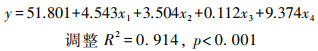
运用岭回归法[66~67],定量估算研究区各环境因子对表土CIA值的贡献(公式(2))。
|
(2) |
公式(2)中x1、x2、x3和x4分别代表母岩、海拔(km)、坡度(°)和TN含量(%)。在山区,海拔高度显著影响气候条件(气温、降水)和植被类型;坡度影响水-岩接触时间、土壤含水量和植被类型,即:山谷地区海拔和坡度既是典型的地貌要素,又可作为气候、植被和土壤水分的代用指标[68]。土壤中TN的转化、吸收和累积过程与土壤微生物性质和群落组成密切相关,所以土壤TN可作为生物作用的替代指标[69]。
比较实测数据计算的CIA值与模型计算的CIA值(图 8),平均绝对离差为3.42。模型有统计学意义,计算结果准确度较高。

|
图 8 CIA实测值与计算值的关系 Fig. 8 Relationship between measured CIA and calculated CIA |
回归模型中的标准化系数常被用于比较各个自变量对因变量的贡献[70]。公式(2)中x1、x2、x3和x4的标准化系数分别是0.690、0.273、0.120和0.080,据此计算得出母岩、海拔、坡度和TN含量对研究区表层土壤CIA值的贡献分别为57.34 %、23.46 %、10.33 %和6.87 %。显然,母岩性质是研究区表层土壤矿物化学风化的主要控制因素;地貌条件(海拔和坡度)是驱动化学风化过程的最重要外部因素,并且海拔高度变化对CIA值的影响较坡度大,这是由于海拔高度变化不仅改变气温和降水,而且影响植物群落物种组成和密度;生物作用对CIA值有一定的贡献。
4 结论化学风化是地表岩石矿物向土壤释放营养元素同时形成土壤粘粒组分的地球化学过程。这一过程促使土壤具有生态环境功能(如对有机和无机污染物的过滤、缓冲、降解、固定等)。雅砻江下游流域表土化学风化强度的空间差异导致研究区表土粒度组成具有明显的空间异质性:海拔较低(<1300 m)、坡度较大的谷坡草地、稀树草地和林地土壤颗粒较粗,平均粒径3.94~6.35ϕ,平均粘粒含量仅为6.51 %,揭示研究区南部表土环境功能较弱;海拔较高(>2400 m)的缓坡宽谷盆地草地、松林和混交林地土壤颗粒较细,平均粒径变化于7.91~8.57ϕ之间,粘粒含量达39.21 %,这些群落表土生态环境功能较强。对比上陆壳、陆源页岩和我国土壤地球化学基准值,研究区表土的K、P和Si元素含量偏低,Ti、Mn和Fe元素含量偏高。易迁移元素Mg、Ca和Na的含量在不同群落表土间差异较大,一致于区内碳酸盐岩、砂页岩、泥岩广布,硅酸盐岩较少的岩石分布情况和坡面流水侵蚀较强的地表特征。为保障研究区农作物产量和质量,保护区内的土壤资源,需合理施用含K、P化肥及有机肥,同时加强田间管理,减少雨水径流对雅砻江下游梯级水库水体的污染。
CIA值的空间变化和A-CN-K三角图图解均表明研究区西部表土正经历中度向强度风化的发展过程,处于脱硅富铝化进程中;南部表土化学风化程度尚处于低等向中等发展阶段。揭示研究区表层土壤化学风化过程仍具有消耗大气CO2的碳汇潜力。岭回归分析揭示研究区表土化学风化强度的空间差异主要受制于母岩、海拔、坡度和TN含量的影响,各因子对表土CIA值的贡献依次是57.34 %、23.46 %、10.33 %和6.87 %。显然,母岩性质是控制研究区表土化学风化过程的主要因素,地貌要素(海拔和坡度)是驱动化学风化过程的主要外部因素,而且海拔高度的影响大于坡度;生物作用对CIA值有一定的贡献。
致谢: 感谢多位审稿专家与编辑部老师对本文提出宝贵的修改意见,使论文得以完善。
| [1] |
朱永官, 李刚, 张甘霖, 等. 土壤安全:从地球关键带到生态系统服务[J]. 地理学报, 2015, 70(12): 1859-1869. Zhu Yongguan, Li Gang, Zhang Ganlin, et al. Soil security:From Earth's critical zone to ecosystem services[J]. Acta Geographica Sinica, 2015, 70(12): 1859-1869. |
| [2] |
Maher K, Chamberlain C P. Hydrologic regulation of chemical weathering and the geologic carbon cycle[J]. Science, 2014, 343(6178): 1502-1504. DOI:10.1126/science.1250770 |
| [3] |
Acosta J A, Martínez-Martínez S, Faz A, et al. Accumulations of major and trace elements in particle size fractions of soils on eight different parent materials[J]. Geoderma, 2011, 161(1-2): 30-42. DOI:10.1016/j.geoderma.2010.12.001 |
| [4] |
Babechuk M G, Widdowson M, Kamber B S. Quantifying chemical weathering intensity and trace element release from two contrasting basalt profiles, Deccan Traps, India[J]. Chemical Geology, 2014, 363: 56-75. DOI:10.1016/j.chemgeo.2013.10.027 |
| [5] |
Molina A, Vanacker V, Corre M D, et al. Patterns in soil chemical weathering related to topographic gradients and vegetation structure in a High Andean tropical ecosystem[J]. Journal of Geophysical Research:Earth Surface, 2019, 124(2): 666-685. DOI:10.1029/2018JF004856 |
| [6] |
Vasyukova E V, Oliva P, Viers J, et al. Chemical weathering of mafic rocks in boreal subarctic environment(Northwest Russia)under influence of glacial moraine deposits[J]. Chemical Geology, 2019, 509: 115-133. DOI:10.1016/j.chemgeo.2018.12.033 |
| [7] |
Hirschi M, Seneviratne S I, Alexandrov V, et al. Observational evidence for soil-moisture impact on hot extremes in Southeastern Europe[J]. Nature Geoscience, 2011, 4(1): 17-21. DOI:10.1038/ngeo1032 |
| [8] |
Tuovinen T S, Kolehmainen M, Roivainen P, et al. Nonlinear transfer of elements from soil to plants:Impact on radioecological modeling[J]. Radiation and Environmental Biophysics, 2016, 55(3): 393-400. DOI:10.1007/s00411-016-0655-4 |
| [9] |
Muhs D R. The geochemistry of loess:Asian and North American deposits compared[J]. Journal of Asian Earth Sciences, 2018, 155: 81-115. DOI:10.1016/j.chemgeo.2018.12.033 |
| [10] |
Jeong G Y, Hillier S, Kemp R A. Quantitative bulk and single-particle mineralogy of a thick Chinese loess-paleosol section:Implications for loess provenance and weathering[J]. Quaternary Science Reviews, 2008, 27(11-12): 1271-1287. DOI:10.1016/j.quascirev.2008.02.006 |
| [11] |
李楠, 郝青振, 张绪教, 等. 东秦岭黄土物源的常量元素和微量元素地球化学证据[J]. 第四纪研究, 2016, 36(2): 332-346. Li Nan, Hao Qingzhen, Zhang Xujiao, et al. Geochemical evidence for the provenance of loess deposits in the eastern Qinling Mountains, Central China[J]. Quaternary Sciences, 2016, 36(2): 332-346. |
| [12] |
毛沛妮, 庞奖励, 黄春长, 等. 汉江上游黄土常量元素地球化学特征及区域对比[J]. 地理学报, 2017, 72(2): 279-291. Mao Peini, Pang Jiangli, Huang Chunchang, et al. Chemical weathering characteristics and regional comparative study of the loess deposits in the upper Hanjiang River[J]. Acta Geographica Sinica, 2017, 72(2): 279-291. |
| [13] |
聂军胜, 李曼. 柴达木盆地晚中新世河湖相沉积物粒度组成及其古环境意义[J]. 第四纪研究, 2017, 37(5): 1017-1026. Nie Junsheng, Li Man. A grain size study on Late Miocene Huaitoutala section, NE Qaidam Basin, and implications for Asian monsoon evolution[J]. Quaternary Sciences, 2017, 37(5): 1017-1026. |
| [14] |
魏东岚, 沈俊杰, 李永化. 红色风化壳地球化学特征及对古气候演变的响应——以辽南石槽剖面为例[J]. 地理科学, 2018, 38(2): 307-313. Wei Donglan, Shen Junjie, Li Yonghua. Geochemical characteristics of red weathering crust from Shicao profile in southern Liaoning Province and the response of paleoclimate evolution[J]. Scientia Geographica Sinica, 2018, 38(2): 307-313. |
| [15] |
乔彦松, 赵志中, 王燕, 等. 川西甘孜黄土-古土壤序列的地球化学演化特征及其古气候意义[J]. 科学通报, 2010, 55(3): 255-260. Qiao Yansong, Zhao Zhizhong, Wang Yan, et al. Variations of geochemical compositions and the paleoclimatic significance of loess-soil sequence from Ganzi County of western Sichuan Province, China[J]. Chinese Science Bulletin, 2010, 55(3): 255-260. DOI:10.1360/csb2010-55-3-255 |
| [16] |
郭飞, 王婷, 刘宇明, 等. 临夏黄土记录的26万年来季风快速变化[J]. 第四纪研究, 2019, 39(3): 557-564. Guo Fei, Wang Ting, Liu Yuming, et al. Rapid Asian monsoon changes recorded by loess depositions in Linxia since 260 ka B.P.[J]. Quaternary Sciences, 2019, 39(3): 557-564. |
| [17] |
司月君, 牛东风, 李保生, 等. 广东西樵剖面主量元素记录的全新世气候突变[J]. 第四纪研究, 2019, 39(3): 629-641. Si Yuejun, Niu Dongfeng, Li Baosheng, et al. Holocene climate change from major elements in Xiqiaoshan of Guangdong Province, China[J]. Quaternary Sciences, 2019, 39(3): 629-641. |
| [18] |
杨一博, 方小敏, Galy Albert, 等. 柴达木盆地西部第四纪气候变化和流域风化[J]. 第四纪研究, 2018, 38(1): 76-85. Yang Yibo, Fang Xiaomin, Galy Albert, et al. Quaternary climate change and catchment weathering in the western Qaidam Basin[J]. Quaternary Sciences, 2018, 38(1): 76-85. |
| [19] |
Liu C, Deng C. The effect of weathering on the grain-size distribution of red soils in south-eastern China and its climatic implications[J]. Journal of Asian Earth Sciences, 2014, 94: 94-104. DOI:10.1016/j.jseaes.2014.08.027 |
| [20] |
庞奖励, 黄春长, 张旭, 等. 白鹿原人工果树林地土壤和农耕地土壤微形态对比研究[J]. 土壤学报, 2007, 44(5): 793-800. Pang Jiangli, Huang Chunchang, Zhang Xu, et al. Micromorphological features of the cultivated soil and anthropogenic forest soil at Bailuyuan site, Shaanxi Province[J]. Acta Pedological Sinica, 2007, 44(5): 793-800. |
| [21] |
杨忠, 熊东红, 周红艺, 等. 干热河谷不同岩土组成坡地的降水入渗与林木生长[J]. 中国科学(E辑:技术科学), 2003, 33(增刊): 85-93. Yang Zhong, Xiong Donghong, Zhou Hongyi, et al. Dry hot valley of different rock and soil slope of precipitation infiltration and tree growth[J]. Science in China(Series E:Technological Sciences), 2003, 33(Suppl.): 85-93. |
| [22] |
刘伦辉. 横断山区干旱河谷植被类型[J]. 山地学报, 1989, 7(3): 175-182. Liu Lunhui. Vegetation types of the arid valleys in the Hengduan Mountainous region[J]. Mountain Research, 1989, 7(3): 175-182. |
| [23] |
张荣祖. 横断山区干旱河谷[M]. 北京: 科学出版社, 1992: 169-187. Zhang Rongzu. The Dry Valleys of the Hengduan Mountains Region[M]. Beijing: Science Press, 1992: 169-187. |
| [24] |
丁文荣. 横断山区干旱河谷气候变化趋势研究[J]. 生态与农村环境学报, 2013, 29(6): 681-687. Ding Wenrong. Trend of the climate changes in dry valleys of Hengduan Mountains, China[J]. Journal of Ecology and Rural Environment, 2013, 29(6): 681-687. DOI:10.3969/j.issn.1673-4831.2013.06.001 |
| [25] |
闻学泽. 四川西部鲜水河-安宁河-则木河断裂带的地震破裂分段特征[J]. 地震地质, 2000, 22(3): 239-249. Wen Xueze. Character of rupture segmentation of the Xianshuihe-Anninghe-Zemuhe fault zone, Western Sichuan[J]. Seismology and Geology, 2000, 22(3): 239-249. DOI:10.3969/j.issn.0253-4967.2000.03.005 |
| [26] |
陈诗越, 方小敏, 王苏民. 川西高原甘孜黄土与印度季风演化关系[J]. 海洋地质与第四纪地质, 2002, 22(3): 41-45. Chen Shiyue, Fang Xiaomin, Wang Sumin. Relation between the loess stratigraphy on the eastern Tibetan Plateau and Indian monsoon[J]. Marine Geology & Quaternary Geology, 2002, 22(3): 41-45. |
| [27] |
中国科学院中国植被图编辑委员会. 中国植被图集[M]. 北京: 科学出版社, 2001: 477-845. Editorial Committee for Vegetation Map of China, Chinese Academy of Sciences. Vegetation Atlas of China[M]. Beijing: Science Press, 2001: 477-845. |
| [28] |
Folk R L, Ward W C. Brazos River bar:A study in the significance of grain size parameters[J]. Journal of Sedimentary Research, 1957, 27(1): 3-26. DOI:10.1306/74D70646-2B21-11D7-8648000102C1865D |
| [29] |
Nesbitt H W, Young G M. Prediction of some weathering trends of plutonic and volcanic rocks based on thermodynamic and kinetic considerations[J]. Geochimica et Cosmochimica Acta, 1984, 48(7): 1523-1534. DOI:10.1016/0016-7037(84)90408-3 |
| [30] |
Nesbitt H W, Young G M. Early Proterozoic climates and plate motions inferred from major elements chemistry of lutites[J]. Nature, 1982, 299(5885): 715-717. DOI:10.1038/299715a0 |
| [31] |
陈骏, 安芷生, 刘连文, 等. 最近2.5 Ma以来黄土高原风尘化学组成的变化与亚洲内陆的化学风化[J]. 中国科学:地球科学, 2001, 31(2): 136-145. Chen Jun, An Zhisheng, Liu Lianwen, et al. Variations of chemical compositions of the eolian dust in Chinese Loess Plateau over the past 2.5 Ma and chemical weathering in the Asian inland[J]. Science China:Earth Sciences, 2001, 31(2): 136-145. |
| [32] |
Nesbitt H W, Markovics G, Price R C. Chemical processes affecting alkalis and alkaline earths during continental weathering[J]. Geochimica et Cosmochimica Acta, 1980, 44(11): 1659-1666. DOI:10.1016/0016-7037(80)90218-5 |
| [33] |
McLennan S M. Weathering and global denudation[J]. The Journal of Geology, 1993, 101(2): 295-303. |
| [34] |
王运生, 李永昭, 向芳. 川西高原甘孜黄土的成因[J]. 地质力学学报, 2003, 9(1): 91-96. Wang Yunsheng, Li Yongzhao, Xiang Fang. The Ganzi loess origin in the west Sichuan Plateau[J]. Journal of Geomechanics, 2003, 9(1): 91-96. DOI:10.3969/j.issn.1006-6616.2003.01.012 |
| [35] |
雷祥义. 秦岭黄土的粒度分析及其成因初步探讨[J]. 地质学报, 1998, 72(2): 178-188. Lei Xiangyi. Grain-size analysis and genesis of loess in the Qinling Mountains[J]. Acta Geologica Sinica, 1998, 72(2): 178-188. DOI:10.3321/j.issn:0001-5717.1998.02.010 |
| [36] |
张龙吴, 张虎才, 常凤琴, 等. 云南异龙湖沉积物粒度空间变化特征及其环境指示意义[J]. 第四纪研究, 2019, 39(5): 1159-1170. Zhang Longwu, Zhang Hucai, Chang Fenqin, et al. Spatial variation characteristics of sediment size and its environmental indication significance in Lake Yilong, Yunnan Province[J]. Quaternary Sciences, 2019, 39(5): 1159-1170. |
| [37] |
王婷, 龙宜澧, 刘星星, 等. 渭河盆地末次冰盛期以来沉积环境变化研究[J]. 第四纪研究, 2019, 39(3): 579-588. Wang Ting, Long Yili, Liu Xingxing, et al. Sedimentary environment evolutions in the Weihe Basin since Last Glacial Maximum[J]. Quaternary Sciences, 2019, 39(3): 579-588. |
| [38] |
傅开道, 杨文辉, 苏斌, 等. 流域环境变化的河流沉积物粒度响应——澜沧江案例[J]. 地理科学进展, 2015, 34(9): 1148-1155. Fu Kaidao, Yang Wenhui, Su Bin, et al. Response of river sediments to basin environmental changes:A case study of the Lancang River[J]. Progress in Geography, 2015, 34(9): 1148-1155. |
| [39] |
Yang S, Jung H S, Li C. Two unique weathering regimes in the Changjiang and Huanghe drainage basins:Geochemical evidence from river sediments[J]. Sedimentary Geology, 2004, 164(1-2): 19-34. DOI:10.1016/j.sedgeo.2003.08.001 |
| [40] |
Campodonico V A, Pasquini A I, Lecomte K L, et al. Chemical weathering in subtropical basalt-derived laterites:A mass balance interpretation(Misiones, NE Argentina)[J]. Catena, 2019, 173: 352-366. DOI:10.1016/j.catena.2018.10.027 |
| [41] |
水利部长江水利委员会.长江流域水土保持公报[R]. 2006-2015. Changjiang Water Resource Committee, Ministry of Water Resources. Bulletin on Water and Soil Conservation in the Changjiang River Basin[R]. 2006-2015. |
| [42] |
张建辉, 李勇, 杨忠. 金沙江干热河谷区人工林生长与土壤母质-母岩的关系[J]. 山地学报, 2001, 19(3): 231-236. Zhang Jianhui, Li Yong, Yang Zhong. Plantation growth to soil parent material/rock in the dry-hot valleys of the Jinsha River[J]. Journal of Mountain Science, 2001, 19(3): 231-236. DOI:10.3969/j.issn.1008-2786.2001.03.007 |
| [43] |
胡萃.川西山地坡面不同土地利用方式下土壤侵蚀研究[D].成都: 四川农业大学硕士学位论文, 2006: 17-30. Hu Cui. The Sloping Land Soil Erosion under Different Land Use in the West of Sichuan[D]. Chengdu: The Master's Thesis of Sichuan Agricultural University, 2006: 17-30. http://d.wanfangdata.com.cn/thesis/Y959300 |
| [44] |
Ndzana G M, Huang L, Wang J B, et al. Characteristics of clay minerals in soil particles from an argillic horizon of alfisol in Central China[J]. Applied Clay Science, 2018, 151: 148-156. DOI:10.1016/j.clay.2017.10.014 |
| [45] |
申聪颖, 赵兰坡, 刘杭, 等. 不同母质发育的东北黑土的粘粒矿物组成研究[J]. 矿物学报, 2013, 33(3): 382-388. Shen Congying, Zhao Lanpo, Liu Hang, et al. A study on clay minerals from different parent material of black soil[J]. Acta Mineralogica Sinica, 2013, 33(3): 382-388. |
| [46] |
Batjes N H. Total carbon and nitrogen in the soils of the world[J]. European Journal of Soil Science, 2014, 65(3): 4-21. DOI:10.1111/ejss.12115 |
| [47] |
Honda M, Yabuki S, Shimizu H. Geochemical and isotopic studies of aeolian sediments in China[J]. Sedimentology, 2004, 51(2): 211-230. DOI:10.1111/j.1365-3091.2004.00618.x |
| [48] |
王学求, 周建, 徐善法, 等. 全国地球化学基准网建立与土壤地球化学基准值特征[J]. 中国地质, 2016, 43(5): 1469-1480. Wang Xueqiu, Zhou Jian, Xu Shanfa, et al. China soil geochemical baselines networks:Data characteristics[J]. Geology in China, 2016, 43(5): 1469-1480. |
| [49] |
McLennan S M. The Continental Crust:Its Composition and Evolution[M]. Oxford: Blackwell, 1985: 1-311.
|
| [50] |
王敬国. 生物地球化学:物质循环与土壤过程[M]. 北京: 中国农业大学出版社, 2017: 312-380. Wang Jingguo. Biogeochemistry:Material Circulation and Soil Processes[M]. Beijing: China Agricultural University Press, 2017: 312-380. |
| [51] |
陈骏, 王鹤年. 地球化学[M]. 北京: 科学出版社, 2004: 35-63. Chen Jun, Wang Henian. Geochemistry[M]. Beijing: Science Press, 2004: 35-63. |
| [52] |
张德, 龙会英, 金杰, 等. 豆科与禾本科牧草间作的生长互作效应及对氮、磷养分吸收的影响[J]. 草业学报, 2018, 27(10): 15-22. Zhang De, Long Huiying, Jin Jie, et al. Effects of growth interaction effect of Leguminous and Gramineous pasture intercropping and absorption of nutrient and phosphorus on pasture expression[J]. Acta Prataculturae Sinica, 2018, 27(10): 15-22. DOI:10.11686/cyxb2017475 |
| [53] |
牟保磊. 元素地球化学[M]. 北京: 北京大学出版社, 1999: 5-51. Mu Baolei. Geochemistry of Elements[M]. Beijing: Peking University Press, 1999: 5-51. |
| [54] |
冯连君, 储雪蕾, 张启锐, 等. 化学蚀变指数(CIA)及其在新元古代碎屑岩中的应用[J]. 地学前缘, 2003, 10(4): 539-544. Feng Lianjun, Chu Xuelei, Zhang Qirui, et al. CIA(chemical index of alteration)and its applications in the Neoproterozoic clastic rocks[J]. Earth Science Frontiers, 2003, 10(4): 539-544. DOI:10.3321/j.issn:1005-2321.2003.04.019 |
| [55] |
琚琛琪, 牛东风, 李保生, 等. 广东西樵山MIS 5a网纹红土常量元素分布及其气候意义[J]. 第四纪研究, 2019, 39(5): 1083-1091. Ju Chenqi, Niu Dongfeng, Li Baosheng, et al. Reticulate laterite constant element distribution and its significance in MIS 5a, Xiqiaoshan, Guangdong Province[J]. Quaternary Sciences, 2019, 39(5): 1083-1091. |
| [56] |
Gaillardet J, Dupré B, Louvat P, et al. Global silicate weathering and CO2 consumption rates deduced from the chemistry of large rivers[J]. Chemical Geology, 1999, 159(1-4): 3-30. DOI:10.1016/S0009-2541(99)00031-5 |
| [57] |
Zeng S, Liu Z, Kaufmann G. Sensitivity of the global carbonate weathering carbon-sink flux to climate and land-use changes[J]. Nature Communications, 2019, 10(1): 1-10. DOI:10.1038/s41467-018-07882-8 |
| [58] |
蒋浩, 徐志方, 赵童, 等. 青藏高原流域岩石风化速率及其控制机制——以贡嘎山地区典型地质背景小流域研究为例[J]. 第四纪研究, 2018, 38(1): 278-286. Jiang Hao, Xu Zhifang, Zhao Tong, et al. The weathering rates and controlling factors of the Tibetan Plateau:A case study of small catchments of typical lithology in Gongga Mountainous area[J]. Quaternary Sciences, 2018, 38(1): 278-286. |
| [59] |
汪苗, 鹿化煜. 雷州半岛玛珥湖区玄武岩的年代、地球化学特征及其意义[J]. 第四纪研究, 2019, 39(5): 1071-1082. Wang Miao, Lu Huayu. Age, geochemical composition and their paleoclimatic implications of the basalt in Leizhou Peninsula, Southern China[J]. Quaternary Sciences, 2019, 39(5): 1071-1082. |
| [60] |
黄颖, 朱丽东, 张晓, 等. 庐山北麓JL红土剖面粉砂粒级元素地球化学特征及其物源意义[J]. 第四纪研究, 2019, 39(5): 1092-1102. Huang Ying, Zhu Lidong, Zhang Xiao, et al. Geochemical characteristics and their provenance implications of the silt fraction from JL red earth section in Lushan region, Jiujiang, South China[J]. Quaternary Sciences, 2019, 39(5): 1092-1102. |
| [61] |
Torres M, Joshua West A, Clark K E. Geomorphic regime modulates hydrologic control of chemical weathering in the Andes-Amazon[J]. Geochimica et Cosmochimica Acta, 2015, 166: 105-128. DOI:10.1016/j.gca.2015.06.007 |
| [62] |
Zapata-Rios X, Mcintosh J, Rademacher L, et al. Climatic and landscape controls on water transit times and silicate mineral weathering in the critical zone[J]. Water Resources Research, 2015, 51(8): 6036-6051. DOI:10.1002/2015WR017018 |
| [63] |
王小芳, 邴海健, 吴艳宏, 等. 小冰期结束以来贡嘎山海螺沟冰川退缩区土壤化学风化与发育过程[J]. 第四纪研究, 2019, 39(5): 1191-1202. Wang Xiaofang, Bing Haijian, Wu Yanhong, et al. Chemical weathering and development of soil in the retreat area of Hailuogou glacier since the end of the Little Ice Age[J]. Quaternary Sciences, 2019, 39(5): 1191-1202. |
| [64] |
Franke W A. The durability of rocks-Developing a test of rock resistance to chemical weathering[J]. American Journal of Science, 2009, 309(8): 711-730. DOI:10.2475/08.2009.04 |
| [65] |
戴开结, 沈有信, 周文君, 等. 云南松根际pH与不同磷水平下云南松幼苗根际pH变化[J]. 西北植物学报, 2005, 25(12): 2490-2494. Dai Kaijie, Shen Youxin, Zhou Wenjun, et al. Rhizosphere pH of Pinus yunnanensis Franch. and rhizosphere pH of P.yunnanensis seedlings at different phosphorous rates[J]. Acta Botanica Boreali-Occidentalia Sinica, 2005, 25(12): 2490-2494. DOI:10.3321/j.issn:1000-4025.2005.12.021 |
| [66] |
张文彤, 董伟. SPSS统计分析高级教程[M]. 北京: 高等教育出版社, 2013: 130-132. Zhang Wentong, Dong Wei. Advanced Tutorial on SPSS Statistical Analysis[M]. Beijing: High Education Press, 2013: 130-132. |
| [67] |
Povak N A, Hessburg P F, McDonnell T C, et al. Machine learning and linear regression models to predict catchment-level base cation weathering rates across the southern Appalachian Mountain region, USA[J]. Water Resources Research, 2014, 50(4): 2798-2814. DOI:10.1002/2013WR014203 |
| [68] |
Bennie J, Huntley B, Wiltshire A, et al. Slope, aspect and climate:Spatially explicit and implicit models of topographic microclimate in chalk grassland[J]. Ecological Modelling, 2008, 216(1): 47-59. DOI:10.1016/j.ecolmodel.2008.04.010 |
| [69] |
Ye C, Chen D, Hall S J, et al. Reconciling multiple impacts of nitrogen enrichment on soil carbon:Plant, microbial and geochemical controls[J]. Ecology Letters, 2018, 21(8): 1162-1173. DOI:10.1111/ele.13083 |
| [70] |
Kim R S. Standardized Regression Coefficients as Indices of Effect Sizes in Meta-Analysis[D]. Tallahassee, United States of America: The Doctoral Dissertation of the Florida State University, 2011: 54-57. https://eric.ed.gov/?q=Effects&id=ED534792
|
 ,
Tao Zhen1
,
Tao Zhen1 ,
Gao Quanzhou1,2,3,
Deng Haojun1,
Yao Ling1,
Li Yinhua1,
Ding Jian1,
Wang Zhengang1,
Li Kun1,
Xu Peng1
,
Gao Quanzhou1,2,3,
Deng Haojun1,
Yao Ling1,
Li Yinhua1,
Ding Jian1,
Wang Zhengang1,
Li Kun1,
Xu Peng1
2 Southern Marine Science and Engineering Guangdong Laboratory(Zhuhai), Zhuhai 519080, Guangdong;
3 Key Laboratory of Mineral Resource & Geological Processes of Guangdong Province, Guangzhou 510275, Guangdong)
Abstract
Rocks/minerals chemical weathering is a superficial geochemical process in which releasing nutrient elements to soil and forming clay minerals in the soil, and simultaneously developing eco-environmental functions of soil. In this study, we selected 10 community plots, located respectively in the different slopes and mountain rift basins (26°32'~34°05'N, 96°52'~102°48'E) with elevation ranging from 1000 m to 3000 m in the lower reaches of the Yalongjiang River on the southeastern Qinghai-Tibetan Plateau, including grassland, savanna, mixed woodland, Leucaena leucocephala woodland, coniferous and broad-leaved mixed forest land, Pinus yunnanensis woodland, wide-valley grassland, corn field, mango orchard and apple orchard, etc., and collected its topsoil samples, respectively. The grain size composition and mineral elemental composition were analyzed, the proxies of grain size and geochemical parameters and the methods of correlation analysis and ridge regression analysis were employed. The objectives of this study were to explore the evolution trend of the topsoil chemical weathering; to quantify the contributions of major controlling factors to the topsoil chemical weathering; and to evaluate the carbon sink potential of the topsoil chemical weathering in the hot-dry valleys of the southwestern China. The results show that the spatial differences of the topsoil chemical weathering intensity resulted in significant spatial heterogeneity of the topsoil grain size composition in the study area. In the south of the study area with lower altitude (below 1300 m) and steeper slope, including grassland, savanna, mixed woodland, Leucaena leucocephala woodland, corn field and mango orchard, the grain size of the topsoil occurs more coarse (mean grain size ranging from 3.94 φ to 6.35 φ) and merely 6.51% of clay content. The topsoil is characterized by relatively weak eco-environmental function. However, in the western study area with higher elevation (above 2400 m) and gentle slope, including wide-valley grassland, Pinus yunnanensis woodland, coniferous and broad-leaved mixed forest land and apple orchard, the grain size of the topsoil exists more finer (mean grain size ranging from 7.91 φ to 8.57 φ) and higher clay content (39.21%). Hence, the topsoil is characterized by stronger eco-environmental function.Comparing with the upper continental crust, terrestrial shale and Chinese soil geochemical baseline values, the content of element K, P, and Si is lower, and the content of element Ti, Mn, and Fe is higher in the topsoil of the study area. The contents of mobile elements (Mg, Ca, and Na) varies widely in the topsoil among the different communities, which is consistent with the rocks features of widespread distribution of carbonate rocks, sand shales and mudstones, and sparse silicate rocks as well as the intensive slope erosion in the study area. For the purpose of ensuring the yield and quality of crops and the soil resources in the study area, it is necessary to rational application of K and P-containing fertilizers and organic fertilizers, and at the same time strengthen field management to reduce the pollution of rainwater runoff carrying nutrients flushing into the cascade reservoirs in the lower Yalongjiang River.The spatial variation of the Chemical Index of Alteration (CIA) and the A-CN-K triangle diagrams show that the topsoil in the western study area is undergoing a moderate-intensity weathering process (the averaged CIA=86), and is in the stage of desilicating and ferrallitic weathering process. The chemical weathering of the topsoil on the steeper slopes in the southern study area is in the lower to medium development stage (the averaged CIA=65), and is in the leaching stage of element Ca and Na. Hence, the topsoil chemical weathering process in the study area may still consume atmospheric CO2 and serve as carbon sinks. The Ridge regression analysis suggested that the spatial differences of the topsoil chemical weathering intensity in the study area were mainly predominated by parent rocks, altitude, slope, and soil TN content, which contribution to the topsoil CIA value is 57.34%, 23.46%, 10.33%, and 6.87%, respectively. Obviously, the nature of the parent rocks is the major factor controlling the topsoil chemical weathering process in the study area. The geomorphological factors (elevation and slope) are the main external factors driving the chemical weathering process, and the impact of the elevation on the CIA value is greater than that of the slope; The biological action contribute limitedly to the CIA value too. This study can provide basic data for deeply discussing soil biogeochemical processes in hot-dry valleys.