2 虚拟地理环境教育部重点实验室(南京师范大学), 江苏 南京 210023;
3 江苏省地理信息资源开发与利用协同创新中心, 江苏 南京 210023;
4 中国地质科学院岩溶地质研究所, 自然资源部/广西岩溶动力学重点实验室, 广西 桂林 541004;
5 重庆师范大学地理与旅游学院, 三峡库区地表过程与环境遥感重庆市重点实验室, 重庆 401331)
千年尺度突变事件被认为是末次冰期气候的固有特征。格陵兰冰芯清晰地记录了末次冰期20多次增温事件,称之为Dansgaard-Oeschger(DO)事件[1]。在DO事件的开始阶段,格陵兰地区在短短几十年内升温8~16℃,而后缓慢变冷[2~3]。Petersen等[4]以DO12为例,用冰盖崩塌和海冰反馈机制的响应模式将DO事件分为5个阶段。自DO事件发现以来,类似事件也在北半球中低纬度的石笋、深海沉积记录中发现[5~10]。但是,南极冰芯与格陵兰冰芯记录的温度变化呈反相位变化,且温度变化相对较缓[11~12]。北半球高低纬度沉积记录中DO事件也呈现出不同的变化模式,中国西南地区新崖洞[13]的DO18事件持续了3ka,远超过格陵兰冰芯记录中DO18的持续时间[12];同一地区的金佛山羊口洞记录也显示DO18缓慢结束的特征[14~15];云南小白龙洞石笋记录整体上与格陵兰冰芯记录相似,但是DO12事件却与南极冰芯Byrd记录极为相似[10],不同于格陵兰冰芯的快速变暖过程[12];四川宋家洞石笋在H4开始之前也呈现出缓慢转型的趋势[16];山西龙洞石笋与格陵兰冰芯δ18O记录的DO25事件在波形特征方面也存在差异[17]。以上证据充分说明亚洲季风区与格陵兰地区所记录的千年尺度DO事件存在显著差异[18~22]。丰都羊子洞的石笋δ18O记录在DO18和DO19事件存在不同响应模式,支持了控制因素的多样性假设[23]。DO事件不同的响应模式也暗示了亚洲季风千年尺度突变事件的驱动机制仍有待进一步探讨。
本文选取陕西省宁强县地洞河石笋的高分辨率氧同位素记录,重建了64.8~33.2kaB.P.阶段秦岭以南米仓山以北亚洲季风的演化历史。在分析亚洲季风区与南北半球高纬地区DO18事件特征的基础上,探讨末次冰期亚洲季风千年尺度气候事件的动力机制。
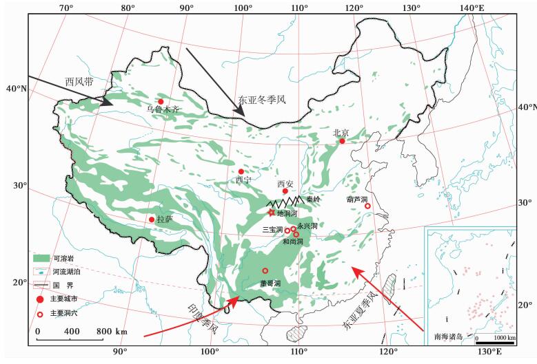
1 洞穴概况地洞河(32°40′45″N,106°32′25″E)位于陕西省汉中市宁强县(图 1),洞口高程1262m,实测洞道长度12069.7m,洞道高差408.1m,洞底投影面积25.5×10⁴m2。洞道主要是受NNE和NW向两组节理控制,形成多层洞道,本次样品采集于上层干洞末端。因该洞穴经多次崩塌充填,石笋沉积区域洞穴密闭性较好。宁强县属北亚热带季风气候,年均温为13℃,多年平均降雨量为1100mm,占比88.1 %,降雨主要集中在夏季(5~8月),占全年降水量的70 % [24~25]。汉中地洞河区域降雨特征与四川盆地、重庆区域相近,降雨量高于秦岭北部西安地区[26],但受到秦岭的截流和米仓山的阻挡,其降雨δ18O的气候意义更为特殊。

|
图 1 地洞河地理位置图(红五星) Fig. 1 Location of Didonghe Cave |
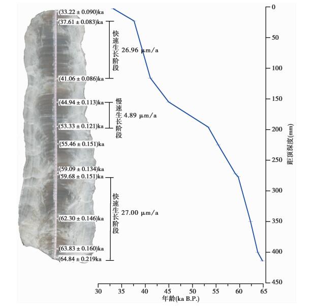
编号为DDH1的石笋样品采集于洞穴末端大厅。DDH1长约417mm,顶底直径相近,约110mm。沿生长轴切开并抛光样品,抛光面生长轴方向和岩性未发现明显的变化,质地较为均匀,中心纹层水平。在111~139mm处石笋岩性发生变化,颜色发白且水平纹层消失,推测该阶段生长速率可能发生变化(图 2)。

|
图 2 样品DDH1抛光面、测年结果及生长速率 Fig. 2 Photo for sample DDH1, the positions of dated sub-samples and grow rate |
本次采样使用直径0.9mm的牙钻在石笋抛光面上采集11件样品,用于U/Th定年,化学分析和提纯方法参照Edwards等[27],分析仪器为MC-ICP-MS Neptune,分析方法参照Shen等[28]和Shao等[29],样品测试在南京师范大学同位素实验室完成,测年仪器分析误差±2σ,年龄分析结果及误差见U系测年结果表 1。同时,沿石笋生长轴,使用0.5mm的牙钻以1mm间距采集417个氧碳同位素样品,由南京师范大学同位素实验室完成,氧碳同位素结果的分析误差小于0.05 ‰,以VPDB标准表示。
| 表 1 石笋DDH1铀系测年结果* Table 1 U-series dating results of stalagmite DDH1 |
石笋DDH1的11个230Th测年结果见表 1。样品238U含量在374~1231ng/g之间变化,232Th含量极低,其变化范围在1~572 pg/g(大部分232Th含量<100 pg/g),保证测年的精度。根据石笋线性内插年龄,长417mm的石笋DDH1生长时段为64.8~33.2kaB.P.;从岩性特征来看未见明显的沉积间断,但局部存在沉积缓慢的阶段。37.61±0.08~41.06±0.09kaB.P.阶段的石笋生长速率较快,为26.96μm/a;59.09±0.13~63.83±0.16kaB.P.阶段的石笋生长速率为27.00μm/a,两个时间段生长速率几乎一致;相反,44.94±0.11~53.33±0.12kaB.P.阶段,石笋的生长速率仅为4.89μm/a(图 2)。通过与南京葫芦洞的记录对比[5~6],DDH1清晰地记录了末次冰期3次典型的弱季风事件即H4、H5a和H6。但石笋DDH1在44.94±0.11~53.33±0.12kaB.P.生长最为缓慢,石笋氧同位素记录的H5弱季风事件并不完整,可能是由于存在不明显的沉积间断导致H5事件的信号没有完全捕捉,因此以DO18的响应机制作为讨论研究的重点。
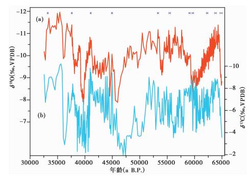
3.2 石笋δ18O序列基于石笋DDH1的U-Th测年结果,将DDH1的年龄进行等间距内插,建立了末次冰期64.8~33.2kaB.P.石笋δ18O时间序列曲线,其平均分辨率为76a。石笋DDH1的碳、氧同位素时间序列如图 3所示。整体上,DDH1的氧同位素与东亚季风区其他石笋δ18O记录的变化趋势一致[5~6, 13, 30~32]。在64.7±0.2kaB.P.至64.0±0.1kaB.P.阶段,DDH1的石笋δ18O由-9.3 ‰快速负偏至-11.4 ‰,指示亚洲季风快速增强;在64.0±0.1kaB.P.至60.4±0.1kaB.P.时段,石笋DDH1的δ18O记录由-11.4 ‰正偏至-8.5 ‰ (振幅达2.9 ‰),证实了DO18结束阶段亚洲季风大幅度减弱,与重庆新崖洞的石笋δ18O记录变化趋势一致[13]。DDH1石笋δ18O记录在59.3±0.1kaB.P.快速负偏,指示末次冰期H6事件结束;在55kaB.P.处存在一处弱季风事件,δ18O偏正振幅达2 ‰,与永兴洞[30~32]、葫芦洞[6]的石笋δ18O记录相比,证实其对应H5a弱季风事件;而38~40kaB.P.之间的弱季风事件,则对应于H4弱季风事件,石笋δ18O振幅达2.8 ‰。综上,石笋DDH1与新崖洞[13]、永兴洞[30~32]、葫芦洞[13]在末次冰期千年尺度变化具有相同的变化趋势。此外,同一区域祥龙洞[33]石笋记录的全新世整体变化趋势与莲花洞[34]、董哥洞[35]一致,但存在十年际-百年际的差异,这说明在长时间尺度上陕南地区石笋δ18O记录的重现性较好[33]。石笋DDH1的δ18O记录虽与格陵兰冰芯[12]、中低纬度其他洞穴石笋δ18O记录在DO18事件变化趋势一致[13,36~37],但其记录的亚洲季风减弱过程的持续时间远长于格陵兰冰芯δ18O记录[12],同时石笋DDH1的δ18O振荡幅度约3 ‰,超过了葫芦洞[5~6]、永兴洞[30~32]、三宝洞[6]、新崖洞[13]的石笋δ18O振幅。石笋DDH1的δ13C记录与δ18O记录在DO18结束过程出现了相同的快速偏重趋势,振幅为3.9 ‰,但内部有多个次级振荡(图 3)。

|
图 3 地洞河DDH1δ18O(a)和δ13C(b)记录 Fig. 3 δ18O(a)and δ13C(b)records of sample DDH1 |
近年来,关于中国石笋δ18O的气候信号解释存在较大争议,大致有冬夏季风降雨的比例[5]、季风强度变化[36~38]、水汽运移过程中的瑞利分馏响应[38~40]、雨量效应[41~43]、环流模式[42]或东亚季风与印度季风的比例等[44~47]。大尺度大气-海洋环流变化引起远距离印度洋水汽和近距离太平洋水汽比例的变化对石笋δ18O记录的值影响很大[45, 48]。Maher和Thompson[49]认为中国洞穴石笋δ18O记录是岁差驱动半球间的温度梯度、温带气压强度和位置移动引起的。从理论上来说,石笋δ18O的变化主要取决于大气降水同位素(δ18Op)信号和洞穴外部的气温变化[44, 50]。基于东亚季风末次冰期气候数值模拟结果,我国华南地区降温幅度在2~4℃之间[51]。假设这一温度变幅属实,根据O'Neil等[52]方解石与水之间的同位素平衡分馏方程(0.24 ‰ /℃)推算可知,温控作用下石笋δ18O值将会产生0.5 ‰ ~1.0 ‰左右的变化。结合同一时期记录可知,石笋DDH1的δ18O值变化幅度为2.9 ‰。显然,洞穴外部气温变化难以诠释石笋δ18O值的变化,剩余1.9 ‰ ~2.4 ‰同位素变化在很大程度上应该来自季风降水的贡献。地处秦岭南麓、米仓山以北的地洞河,夏季降水量约占全年降水总量的70 % [53]。已有研究也表明[19, 53],位于汉江-秦岭一带的石笋δ18O主要反映夏季风强度变化:当夏季风强盛时,降雨量增加,夏季降水占全年降水量比例增加,石笋δ18O偏负;当夏季风减弱时,降雨量减少,夏季降水占全年降水量的比例减少,石笋δ18O偏正。基于上述考量,DDH1石笋δ18O记录的气候解释,也遵循上述观点。但其受地形纬度效应影响,导致西风带环流、东亚季风、西南季风对宁强地洞河的影响与其他区域存在差异性,造成了陕南地区石笋δ18O记录整体趋势同重庆羊口洞[14~15]、新崖洞一致[13],但振幅却差异很大。
4.2 DO18、H6的时标DDH1的Rampfit统计分析结果表明64.0±0.1kaB.P.为DO18开始偏正的转折点(图 4a),DO18向GS18转型时间为60.4±0.1kaB.P.(图 4b),与永兴洞YX55的转型时间差别较大[32],H6结束时间为59.3±0.1kaB.P.。因DDH1的DO18开始过程稍不完整,故取快速偏负的中间点64.7±0.2kaB.P.作为DO18开始的时间。为了验证DDH1石笋记录的准确性,本文整理了葫芦洞[5]、永兴洞[32]、新崖洞[13]、三宝洞[6]石笋δ18O记录的DO18和H6的转型时间。葫芦洞石笋MSL记录的DO18事件开始时间为64.7±0.2kaB.P.[5, 14, 32];永兴洞YX55和YX46样品记录DO18事件开始时间分别为64.7±0.3kaB.P.和64.8±0.2kaB.P.[30~32];新崖洞石笋[13]记录的DO18事件开始时间为64.6±0.5kaB.P.;三宝洞记录的DO18事件不明显[6, 32];NGRIP冰芯记录的DO18开始时间为64.1±0.6kaB.P.[12, 15]。从图 4a可以看出,DDH1的δ18O记录在64.7±0.2kaB.P.时快速负偏,振幅超过了2 ‰。在测年误差范围内,陕南地洞河与葫芦洞[6]、永兴洞[31~32]、新崖洞[13]石笋δ18O所记录的季风增强过程基本一致,体现了我国洞穴石笋δ18O大尺度响应的同时性,也验证了DDH1测年的准确性[6, 13~14, 30~31]。但亚洲季风区各地石笋记录的DO18事件转型时间存在较大的差异。永兴洞YX55记录DO18向GS18的转型时间为62.6kaB.P.[30~32],YX46记录的转型时间为63.0kaB.P.[30~32],二者在测年误差范围内较为一致[32]。重庆新崖洞[13]和陕南地洞河记录的DO18事件没有发生与永兴洞[32]类似的明显转型过程,其季风减弱过程的变率基本保持一致。

|
图 4 Rampfit软件获取的石笋DDH1在H6 (b)和DO18 (a)的转型时间节点 Fig. 4 Transfer timing of stalagmite DDH1 in H6 and DO18 by rampfit software |
石笋DDH1记录的DO18事件(64.7±0.2~60.4±0.1kaB.P.)由暖转冷过程持续了近4ka,其石笋δ18O值从-11.4 ‰缓慢正偏至-8.5 ‰,振荡幅度达到了2.9 ‰ (图 5f)。因葫芦洞[5~6]和三宝洞[6]石笋样品分辨率较低,其氧同位素在整个季风减弱过程中振幅小于1 ‰ (图 5b和5c),另外也可能是这两个洞穴系统对此事件的响应不敏感[5~6]。而此事件在湖北永兴洞石笋YX55的δ18O记录却异常显著[30~32],其石笋δ18O出现2 ‰的正偏(图 5d)。重庆新崖洞[13]的石笋δ18O记录也表明DO18事件结束过程持续了较长时间且在季风减弱过程δ18O值具有1.5 ‰的显著偏重(图 5e)。重庆羊口洞石笋δ18O记录的DO18事件振幅为1.5 ‰ [14~15](图 6d)。通过石笋δ18O记录的DO18事件振荡幅度的区域对比,陕西汉中地洞河石笋的δ18O记录偏正幅度较大,是重庆新崖洞的2倍(图 5e)[13],葫芦洞和三宝洞的3倍多(图 5b和5c)[6, 36]。

|
图 5 地洞河DDH1石笋DO18事件δ18O序列与其他记录的对比 (a)北格陵兰冰芯NGRIP(NGRIP)[12];(b)南京葫芦洞MSL(32°03′N,119°02′E)[5~6];(c)湖北三宝洞SB22(31°40′N,110°26′E)[6];(d)湖北永兴洞YX55(31°35′N,111°14′E)[32];(e)重庆新崖洞XY2(30°45′N,109°28′E)[13];(f)陕西汉中地洞河DDH1(32°41′N,106°32′E)其中从右到左的阴影条带分别代表石笋记录DO18的开始时间和冰芯记录的DO18事件、石笋记录的DO18转型或者次级气候事件以及部分表示H6事件结束过程的转型时间 Fig. 5 Detailed comparison of DO18 events between Didonghe δ18O record and other cave records. (a)NGRIP from ice core in North Greenland[12]; (b)MSL from Hulu Cave in Jiangsu(32°03′N, 119°02′E)[5~6]; (c)SB22 from Sanbao Cave in Hubei(31°40′N, 110°26′E)[6]; (d)YX55 from Yongxing Cave in Hubei(31°35′N, 111°14′E)[32]; (e)XY2 from Xinya Cave in Chongqing(30°45′N, 109°28′E)[13]; (f)DDH1 from Didonghe Cave in Shaanxi(32°41′N, 106°32′E). The bars from right to left indicate the onset of DO18 in cave sediment and DO18 intervals in Greenland ice core, the small transition from DO18 to GS18 in other cave sediment or sub-millennial event in DDH1, and the end of H6, respectively |
在DO18事件的结束过程,永兴洞[32]和DDH1石笋的δ18O记录表明两者在转型时间和季风减弱速率存在明显差异。永兴洞的石笋δ18O在65.0~62.2kaB.P.期间经历了相对较大幅度的,快速正偏,说明季风减弱过程相对迅速,而在62.2kaB.P.之后永兴洞石笋δ18O记录的季风减弱幅度并不显著[31~32]。新崖洞[13]石笋δ18O记录的季风减弱速度介于永兴洞[31~32]与地洞河之间。可以看到在62.2kaB.P.(图 5e和图 6e),新崖洞石笋δ18O继续偏正,但是转型不明显。而地洞河石笋DDH1的δ18O记录在整个季风减弱过程δ18O偏正速度稳定,但在62.2~61.8kaB.P.阶段,石笋δ18O记录也经历了短时间的偏负,之后恢复了之前的偏重速率,这说明地洞河DDH1与其他地区的石笋一致反映了在DO18事件缓慢结束过程存在一次较为普遍的季风增强事件[6, 13, 30~32, 36],但各地石笋δ18O记录的事件幅度差异较大。

|
图 6 南北半球高、低纬地区DO18的模式对比 (a)北格陵兰冰芯NGRIP(North Greenland Ice Core Project members,2004)[12];(b)陕西汉中地洞河DDH1(32°41′N,106°32′E);(c)南京葫芦洞MSL(32°03′N,119°02′E)[5~6];(d)重庆羊口洞JFYK07(29°02′N,107°11′E)[14];(e)重庆新崖洞XY2(30°45′N,109°28′E)[13];(f)Cariaco盆地总反射率[62];(g)南极EDML冰芯(EPICA Community members,2006)[59] Fig. 6 Detailed comparison of DO18 patterns in high and low latitude of northern and southern hemispheres. (a)NGRIP from ice core in North Greenland[12]; (b)DDH1 from Didonghe Cave in Shaanxi(32°41′N, 106°32′E); (c)MSL from Hulu Cave in Jiangsu(32°03′N, 119°02′E)[5~6]; (d)JFYK07 from Yangkou Cave in Chongqing(29°02′N, 107°11′E)[14]; (e)XY2 from Xinya Cave in Chongqi(30°45′N, 109°28′E)[13]; (f)Reflectance record from Cariaco Basin[62]; (g)EDML from ice core in Antarctic[59] |
地洞河石笋δ18O记录较三宝洞、永兴洞、新崖洞、葫芦洞记录显著负偏[6, 13, 30~32, 36]。因洞穴石笋δ18O变化主要由大气降水同位素组成和温度变化控制,印度洋源区和太平洋源区水汽比例的改变和降雨量的变化会引起石笋δ18O随着纬度升高而贫化[45, 50]。山脉与高原的阻挡会引起水汽在山前形成降雨,太行山两侧山西地区降雨δ18Op较河北地区偏重[54],同样藏北地区也出现与纬度效应相反的局地降雨δ18Op偏重,说明了由于近源河流、湖泊等水汽富集了较重的δ18O,造成了因局地近源水增加而引起的背风面降雨δ18Op偏重;而迎风面因海洋源区的水汽比例较大而降雨δ18Op偏负[55]。通过对比这些洞穴石笋δ18O记录的振荡幅度和变化过程[6, 13, 15, 32],推测地洞河地区因处于北半球偏高纬度(图 5f),石笋δ18O记录随纬度升高出现δ18O逐渐贫化,加上秦巴山脉的阻挡造成远源水汽团较为偏轻的δ18Op在宁强地区形成大规模降雨。纬度和地形的双重影响使得汉中地洞河DDH1的δ18O记录比其他地区偏负。这说明汉中地区石笋δ18O受到了局部水汽源和地形分馏的影响。
4.4 DO18事件高低纬度的响应差异随着末次冰期不同纬度不同记录千年尺度气候事件研究的深入,基本形成了格陵兰冰芯DO事件呈“倒三角形”,以突然升温缓慢降温为特征[56~59];南极冰芯记录呈现“等腰梯形”[11, 59~60],降温过程和升温过程近似对称,都较为缓慢;低纬度季风记录的DO事件呈“规则矩形”,在不同区域稍有差异[5~6, 8, 61]。而热带地区石笋记录的DO事件远不如H事件显著,Carolin等[61]根据婆罗洲石笋记录的显著H事件和模糊的DO事件提出了低纬和高纬的千年振荡可能是响应不同机制或者是DO事件的强度不够,不足以引起北婆罗洲地区水文系统的重组。但在北高纬格陵兰冰芯中,DO系列暖事件持续时间长短不一[12]。尤其是DO18事件在格陵兰冰芯的持续时间仅为400a(图 6a)[1, 12],但在DDH1石笋记录中却长达4ka(图 6b),其持续的时间是冰芯记录的DO18持续时间的10倍左右。与该阶段南极冰芯峰形变化相比,DDH1石笋δ18O记录与南极EDML冰芯的δ18O记录反相位更为一致[59](图 6g),表明亚洲季风很可能是受到了南北半球气候的共同影响[35]。
从64.0±0.1kaB.P.开始,DDH1石笋δ18O记录的亚洲季风减弱,DO18事件进入结束阶段,与中低纬度Cariaco盆地相一致[62],同时其变化模式与南极EDML冰芯记录表现一致[59]。这说明当北半球DO18事件短时间内结束[12],北高纬度气温降低,中低纬度的石笋δ18O虽记录了DO18事件快速开始缓慢结束的趋势[13, 30~32],但石笋记录在短时间内并未达到与北高纬度记录相一致的结果[12]。相反,此时南半球逐渐升温[63],促使南北半球温差增大。大量研究表明热带辐合带(Intertropical Convergence Zone,简称ITCZ)移动主要与两半球温差有关,同时与云量控制和热量传输相关联,向温度较高的半球移动[62~63]。那么,当北格陵兰冰芯指示的DO18事件经历大约不到400a的温暖时期[12],迅速进入冷阶并持续较长时间,导致北高纬海冰扩张,海冰反照率增加和隔热效应进一步促进了北高纬变冷[4]。北高纬冷空气通过北大西洋-西风带进入到中国大陆[64];同时,北高纬变冷必然引起北大西洋经向反转流(Atlantic Meridional Circulation,简称AMOC)一定程度减弱,甚至当进入H6阶段,AMOC几乎停止[65]。这导致南半球积累的热量持续增加,进一步维持了南半球温度,增加了南北半球的温度梯度[66]。长时间尺度上,当南半球成为较暖的半球,ITCZ向南半球移动[66]。同时,ITCZ在夏季向北半球移动的幅度也逐步减弱,中国西南地区石笋记录的夏季风也随之减弱[14]。根据洋流和大气能量补偿机制,向北的越赤道流减弱,使得DDH1在千年尺度DO18事件的表现形式与南极冰芯记录更为一致[60]。南大洋温度和水汽潜热释放通过越赤道气流影响亚洲季风强度的变化[14, 67]。
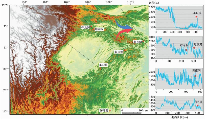
因青藏高原对西风带的阻挡和分流作用,对东亚季风强烈地牵引作用和阻挡作用,使得东亚季风区的降雨重新进行了分配[64]。宁强地处秦岭南坡,其气候变化主要受控于亚洲季风系统,并因青藏高原和秦岭的地形阻隔导致该地区的降雨特征存在特殊性[33]。陕南地区石笋记录的小冰期阶段该地区出现了降雨增加的趋势[67]。西风带、东亚冬季风和夏季风共同控制了陕南地区的降雨变化,但因青藏高原和秦岭的地形阻挡,引起冬季风和西风带对陕南区域的影响快速衰减,北高纬作用强度减弱,相对提高了低纬或者南半球作用的强度,而低纬或南半球作用强度又与半球温度梯度引起的ITCZ移动的幅度有关。从图 7地形剖面可以看出,从西向东依次为地洞河、羊口洞[14]、新崖洞[13]和永兴洞[32]。这4个洞穴皆分布于青藏高原东南侧一带,其受青藏高原阻隔或者青藏高原加秦岭阻隔作用依次减少,西风带与青藏高原南支绕流在北纬33°N,东经110°E处辐合向东[64],到110°E以东青藏高原的阻隔基本消失,形成了青藏高原向长江中下游传输水汽的缺口[68]。夏季,西风带北移,四川盆地周边洞穴石笋的氧同位素记录则主要反应低纬季风水文变化过程和热源释放[13~15];冬季,永兴洞[32]受北高纬影响的程度介于葫芦洞[6]和地洞河区域之间。东部区域冬季风长驱直入到淮海地区,当北高纬变冷,鄱阳湖地区出现沙山沉积[69],葫芦洞石笋δ18O记录也成功地记录冬夏季风的强度的变化,证实该区域冬夏季风的交替作用[6]。所以中国东部石笋[6]记录的千年尺度事件变化幅度与重庆羊口洞[14~15]、湖北永兴洞[32]都存在较大差异。因此,青藏高原东部地区石笋δ18O记录的差异性是地形引起亚洲季风系统差异性表达的结果,北高纬作用的贡献比例相对降低,低纬甚至南半球影响的贡献比例相对增强。叠加南北半球温差控制的ITCZ向北移动范围的减弱而使得石笋δ18O记录长时间持续正偏,体现更为强烈的南半球信号。

|
图 7 地形阻挡效应区洞穴位置(蓝色箭头为西风带,红色箭头为青藏高原南支绕流) Fig. 7 Cave location in the terrain blocking region(blue arrow, Westerlies; Red arrow, south branch flow of the Tibetan Plateau) |
(1) 本文利用陕西汉中地洞河一支长417mm的高分辨率、精确定年的石笋δ18O记录,重建了64.8~33.2kaB.P.的亚洲季风变化历史。石笋δ18O记录了DO18事件在64.7±0.2kaB.P.开始,60.4±0.1kaB.P.时结束的整个过程,并显示石笋δ18O值从-11.4 ‰缓慢正偏至-8.5 ‰,振荡幅度达到了2.9 ‰。DDH1石笋的δ18O所记录的DO18快速开始的时间与石笋、冰芯记录具有很好的同步性,但其持续的时间是冰芯记录的DO18持续时间的10倍左右。而其他石笋记录将62.2~62.6kaB.P.阶段作为DO18向GS18转型的时间,石笋DDH1也出现了氧同位素偏重过程的一个次级波动,但不如永兴洞明显。DDH1记录的H6冷事件在59.3±0.1kaB.P.快速结束,与格陵兰冰芯、金佛羊口洞的石笋记录的时标一致。
(2) DDH1记录的DO18事件在持续时间和结束过程与Cariaco盆地、南极冰芯EDML的记录更为一致,呈现长时间大幅度变化结构特征。而格陵兰在其DO18事件短暂结束之后,其缓慢升温过程仅仅体现在其对东亚季风区石笋δ18O记录约400a的短暂波动的影响。DO18事件结束过程,南半球温度和水汽潜热的释放,以及越赤道流对亚洲季风强度的影响起到了至关重要的作用。
(3) 地洞河所处青藏高原、秦岭叠加影响的区域,大大削弱了北高纬作用的贡献比例而相对增加了低纬甚至是南半球作用的贡献比例,导致这一区域石笋记录的千年事件特征与东部季风区不一致。DDH1记录的DO18事件自64.0±0.1kaB.P.逐渐减弱过程与南极冰芯一致的表现可能是南半球升温增加了两半球的温度梯度,导致ITCZ在夏季向北半球移动的幅度逐步减弱,中国西南地区石笋记录的夏季风也随之减弱。地洞河地区因处于北半球偏高纬度,随纬度升高δ18O逐渐贫化,加上秦巴山脉的阻挡造成远源水汽团较为偏轻的δ18Op在宁强地区形成大规模降雨。纬度和地形的双重影响使得汉中地洞河DDH1的δ18O比其他地区偏负,反映了更大幅度DO18事件振荡过程。
致谢: 感谢审稿专家和编辑部老师给予的建设性修改意见。
| [1] |
Dansgaard W, Clausen H B, Gundestrup N, et al. A new Greenland deep ice core[J]. Science, 1982, 218(4579): 1273-1277. DOI:10.1126/science.218.4579.1273 |
| [2] |
Huber C, Leuenberger M, Spahni R, et al. Isotope calibrated Greenland temperature record over Marine Isotope Stage 3 and its relation to CH4[J]. Earth and Planetary Science Letters, 2006, 243(3-4): 504-519. DOI:10.1016/j.epsl.2006.01.002 |
| [3] |
Landais A, Caillon N, Goujon C, et al. Quantification of rapid temperature change during DO event 12 and phasing with methane inferred from air isotopic measurements[J]. Earth and Planetary Science Letters, 2004, 225(1-2): 221-232. DOI:10.1016/j.epsl.2004.06.009 |
| [4] |
Petersen S V, Schrag D P, Clark P U. A new mechanism for Dansgaard-Oeschger cycles[J]. Paleoceanography and Paleoclimatology, 2013, 28(1): 24-30. |
| [5] |
Wang Y J, Cheng H, Edwards R L, et a1. A high-resolution absolute dated Late Pleistocene monsoon record from Hulu Cave, China[J]. Science, 2001, 294(5550): 2345-2348. DOI:10.1126/science.1064618 |
| [6] |
Wang Y J, Cheng H, Edwards R L, et al. Millennial-and orbital-scale changes in the East Asian monsoon over the past 224, 000 years[J]. Nature, 2008, 7182(451): 1090-1093. DOI:10.1038/nature06692 |
| [7] |
Bums S J, Fleitmann D, Maaer A, et a1. Indian Ocean climate and all absolute chronology over Dansgaard-Oeschger events 9-13[J]. Science, 2001, 301(5638): 1365-1367. |
| [8] |
Cheng H, Edwards R L, Wang Y J, et a1. A penultimate glacial monsoon record from the Hulu Cave and two-phase glacial terminations[J]. Geology, 2006, 34(3): 217-220. |
| [9] |
Leuschner D C, Sirocko F. The low-latitude monsoon climate during Dansgaard-Oeschger cycles and Heinrich events[J]. Quaternary Science Reviews, 2000, 19(1-5): 243-254. DOI:10.1016/S0277-3791(99)00064-5 |
| [10] |
Cai Y J, An Z S, Cheng H, et a1. High-resolution absolute-dated Indian monsoon record between 53 and 36 ka from Xiaobailong Cave, Southwestern China[J]. Geology, 2006, 34(8): 621-624. DOI:10.1130/G22567.1 |
| [11] |
Blunier T, Chappellaz J, Schwander J, et a1. Asynchrony of Antarctica and Greenland climate during the last glacial[J]. Nature, 1998, 394(6695): 739-743. DOI:10.1038/29447 |
| [12] |
North Greenland Ice Core Project Members. High-resolution record of Northern Hemisphere climate extending into the last interglacial period[J]. Nature, 2004, 431(7005): 147-151. DOI:10.1038/nature02805 |
| [13] |
Li T Y, Yuan D X, Li H C, et al. High resolution climate variability of Southwest China during 57-70 ka reflected in a stalagmite δ18O record from Xinya Cave[J]. Science in China(Series D), 2007, 50(8): 1202-1208. DOI:10.1007/s11430-007-0059-z |
| [14] |
Zhang T T, Li T Y, Cheng H, et al. Stalagmite-inferred centennial variability of the Asian summer monsoon in Southwest China between 58 and 79 ka[J]. Quaternary Science Reviews, 2017, 160(2017): 1-12. |
| [15] |
Han L Y, Li T Y, Cheng H, et al. Potential influence of temperature changes in the Southern Hemisphere on the evolution of the Asian summer monsoon during the Last Glacial period[J]. Quaternary International, 2016, 392: 239-250. DOI:10.1016/j.quaint.2015.05.068 |
| [16] |
Zhou H Y, Zhao J X, Feng Y X, et al. Heinrich event 4 and Dansgaard/Oeschger events 5-10 recorded by high-resolution speleothem oxygen isotope data from Central China[J]. Quaternary Science Reviews, 2014, 82(2): 394-404. |
| [17] |
董进国, 赵侃, 沈川洲, 等. 黄土高原石笋记录的DO25季风增强事件[J]. 第四纪研究, 2016, 36(6): 1502-1509. Dong Jinguo, Zhao Kan, Shen Chuan-chou, et al. Strong East Asian summer monsoon during the DO25 event recorded by an absolute-dated stalagmite from Dragon Cave, Northern China[J]. Quaternary Sciences, 2016, 36(6): 1502-1509. |
| [18] |
Liu D B, Wang Y J, Cheng H, et al. A detailed comparison of Asian monsoon intensity and Greenland temperature during the Allerød and Younger Dryas events[J]. Earth and Planetary Science Letters, 2008, 272(3-4): 691-697. DOI:10.1016/j.epsl.2008.06.008 |
| [19] |
Liu D B, Wang Y J, Cheng H, et al. Centennial-scale Asian monsoon variability during the mid-Younger Dryas from Qingtian Cave, Central China[J]. Quaternary Research, 2013, 80(2): 199-206. |
| [20] |
Ma Z B, Cheng H, Tan M, et al. Timing and structure of the Younger Dryas event in Northern China[J]. Quaternary Science Reviews, 2012, 41: 83-93. DOI:10.1016/j.quascirev.2012.03.006 |
| [21] |
王权, 汪永进, 刘殿兵, 等. DO3事件的湖北神农架高分辨率年纹层石笋记录[J]. 第四纪研究, 2017, 37(1): 108-117. Wang Quan, Wang Yongjin, Liu Dianbing, et al. The DO3 event in Asian monsoon climates evidenced by an annually laminated stalagmite from Qiangtian Cave, Mt[J]. Quaternary Sciences, 2017, 37(1): 108-117. |
| [22] |
Duan F C, Liu D B, Cheng H, et al. A high-resolution monsoon record of millennial-scale oscillations during late MIS3 from Wulu Cave, south-west China[J]. Journal of Quaternary Science, 2014, 29(1): 83-90. |
| [23] |
孙喜利, 杨勋林, 史志超, 等. 石笋记录的西南地区MIS4阶段夏季风的演化[J]. 第四纪研究, 2017, 37(6): 1370-1380. Sun Xili, Yang Xunlin, Shi Zhichao, et al. The evolution of summer monsoon in Southwest China during MIS4 as revealed by stalagmite δ18O record[J]. Quaternary Sciences, 2017, 37(6): 1370-1380. |
| [24] |
胡江波, 鲁学忠, 苏俊辉. 近51年宁强县气候特征分析[J]. 陕西气象, 2010, 3: 18-21. Hu Jiangbo, Lu Xuezhong, Su Junhui. Analysis of climate characteristic in Ningqiang County during the last 51 years[J]. Journal of Shaanxi Meteorology, 2010, 3: 18-21. DOI:10.3969/j.issn.1006-4354.2010.03.005 |
| [25] |
Tan L C, Yi L, Cai Y J, et al. Quantitative temperature reconstruction based on growth rate of annually-layered stalagmite:A case study from Central China[J]. Quaternary Science Reviews, 2013, 72(2): 137-145. |
| [26] |
吴健华, 李培月, 钱会. 西安市气象要素变化特征及可利用降雨量预测模型[J]. 南水北调与水利科技, 2013, 11(64): 50-54+74. Wu Jianhua, Li Peiyue, Qian Hui. Variation characteristics of meteorological elements and prediction model of available precipitation in Xi'an City[J]. South to North Water Transfers and Water Science and Technology, 2013, 11(64): 50-54+74. |
| [27] |
Edwards R L, Chen J H, Wasserburg G J, et al. 238U-234U-230Th-232Th systematics and the precise measurement of time over the past 500, 000 years[J]. Earth and Planetary Science Letters, 1987, 81(2-3): 175-192. DOI:10.1016/0012-821X(87)90154-3 |
| [28] |
Shen C C, Edwards L R, Cheng H, et al. Uranium and thorium isotopic and concentration measurements by magnetic sector inductively coupled plasma mass spectrometry[J]. Chemical of Geology, 2002, 185(3-4): 165-178. DOI:10.1016/S0009-2541(01)00404-1 |
| [29] |
Shao Q, Bahain J J, Wang W, et al. Coupled ESR and U-series dating of Early Pleistocene Gigantopithecus faunas at Mohui and Sanhe caves, Guangxi, Southern China[J]. Quaternary Geochronology, 2015, 30: 524-528. DOI:10.1016/j.quageo.2015.04.008 |
| [30] |
陈仕涛.跨越南北半球的末次冰期东亚季风事件[D].南京: 南京师范大学博士学位论文, 2011: 39-40. Chen Shitao. Monsoon Event across the Northern and Southern Hemisphere in the Last Glacial Period[D]. Nanjing: The Doctor Thesis of Nanjing Normal University, 2011: 39-40. |
| [31] |
Chen S T, Wang Y J, Cheng H, et al. Strong coupling of Asian monsoon and Antarctic climates on sub orbital timescales[J]. Scientific Reports, 2016, 6(1): 32995. DOI:10.1038/srep32995 |
| [32] |
张伟宏, 廖泽波, 陈仕涛, 等. 湖北高分辨率石笋记录的DO18事件特征[J]. 沉积学报, 2018, 36(4): 674-683. Zhang Weihong, Liao Zebo, Chen Shitao, et al. DO18 event depicted by a high-resolution stalagmite record from Yongxing Cave, Hubei Province[J]. Acta Sedimentologica Sinica, 2018, 36(4): 674-683. |
| [33] |
谭亮成, 蔡演军, 安芷生, 等. 石笋氧同位素和微量元素记录的陕南地区4200-2000 a B.P.高分辨率季风降雨变化[J]. 第四纪研究, 2014, 34(6): 1238-1245. Tan Liangcheng, Cai Yanjun, An Zhisheng, et al. High resolution monsoon precipitation variations in southern Shaanxi, Central China during 4200-2000 a B.P. as revealed by speleothem δ18O and Sr/Ca records[J]. Quaternary Sciences, 2014, 34(6): 1238-1245. |
| [34] |
Hu C Y, Henderson G M, Huang, J H, et al. Quantification of Holocene Asian monsoon rainfall from spatially separated cave records[J]. Earth and Planetary Science Letters, 2008, 266(3-4): 221-232. DOI:10.1016/j.epsl.2007.10.015 |
| [35] |
Duan F C, Wang Y J, Shen C C, et al. Evidence for solar cycles in a Late Holocene speleothem record from Dongge Cave, China[J]. Scientific Reports, 2014, 4: 51-59. DOI:10.1038/srep05159 |
| [36] |
Cheng H, Edwards R L, Sinha A, et al. The Asian monsoon over the past 640, 000 years and ice age terminations[J]. Nature, 2016, 534(7609): 640-646. DOI:10.1038/nature18591 |
| [37] |
黄冉, 陈朝军, 李廷勇, 等. 基于石笋记录的晚全新世太平洋东西两岸季风区气候事件对比研究[J]. 第四纪研究, 2019, 39(3): 742-754. Huang Ran, Chen Chaojun, Li Tingyong, et al. Comparison of climatic events in the Late Holocene, based on stalagmite records from monsoon regions near by the east and west Pacific[J]. Quaternary Sciences, 2019, 39(3): 742-754. |
| [38] |
崔梦月, 洪晖, 孙晓双, 等. 福建仙云洞石笋记录的新仙女木突变事件结束时的缓变特征[J]. 第四纪研究, 2018, 38(3): 711-719. Cui Mengyue, Hong Hui, Sun Xiaoshuang, et al. The gradual change characteristics at the end of the Younger Dryas event inferred from a speleothem record from Xianyun Cave, Fujian Province[J]. Quaternary Sciences, 2018, 38(3): 711-719. |
| [39] |
Maher B A. Holocene variability of the East Asian summer monsoon from Chinese cave records:A re-assessment[J]. The Holocene, 2008, 18(6): 861-866. DOI:10.1177/0959683608095569 |
| [40] |
Yuan D X, Cheng H, Edwards R L, et al. Timing, duration, and transitions of the last interglacial Asian monsoon[J]. Science, 2004, 304(5670): 575-578. DOI:10.1126/science.1091220 |
| [41] |
赵侃, 孔兴功, 程海, 等. MIS3晚期东亚季风强度和DO事件年龄[J]. 第四纪研究, 2008, 28(1): 177-183. Zhao Kan, Kong Xinggong, Cheng Hai, et al. Intensity and timing of D-O events of East Asian monsoon during the late episode of MIS3[J]. Quaternary Sciences, 2008, 28(1): 177-183. DOI:10.3321/j.issn:1001-7410.2008.01.020 |
| [42] |
张键, 李廷勇. "雨量效应"与"环流效应":近1 ka亚澳季风区石笋和大气降水δ18O的气候意义[J]. 第四纪研究, 2018, 38(6): 1532-1544. Zhang Jian, Li Tingyong. "Amount effect" vs."Circulation effect":The climate significance of precipitation and stalagmite δ18O in the Asian-Australian monsoon region over the past 1 ka[J]. Quaternary Sciences, 2018, 38(6): 1532-1544. |
| [43] |
Cai Y J, Tan L C, Cheng H, et al. The variation of summer monsoon precipitation in Central China since the last deglaciation[J]. Earth and Planetary Science Letters, 2010, 291(1-4): 21-3l. DOI:10.1016/j.epsl.2009.12.039 |
| [44] |
Tan M. Circulation effect:Response of precipitation δ18O to the ENSO cycle in monsoon regions of China[J]. Climate Dynamics, 2014, 42(3-4): 1067-1077. DOI:10.1007/s00382-013-1732-x |
| [45] |
谭明, 南素兰, 段武辉. 中国季风区大气降水同位素的季节尺度环流效应[J]. 第四纪研究, 2016, 36(3): 575-580. Tan Ming, Nan Sulan, Duan Wuhui. Seasonal scale circulation effect of stable isotope in atmospheric precipitation in the monsoon regions of China[J]. Quaternary Sciences, 2016, 36(3): 575-580. |
| [46] |
陈建徽, 饶志国, 刘建宝, 等. 全新世东亚夏季风最强盛期出现在何时?——兼论中国南方石笋氧同位素的古气候意义[J]. 中国科学:地球科学, 2016, 46(11): 1494-1504. Chen Jianhui, Rao Zhiguo, Liu Jianbao, et al. On the timing of the East Asian summer monsoon maximum during the Holocene-Does the speleothem oxygen isotope record reflect monsoon rainfall variability?[J]. Scientia China:Earth Sciences, 2016, 46(11): 1494-1504. |
| [47] |
蒋文静, 赵侃, 陈仕涛, 等. 小冰期十年际尺度亚洲季风变化的四川黑竹沟洞石笋记录[J]. 第四纪研究, 2017, 37(1): 118-129. Jiang Wenjing, Zhao Kan, Chen Shitao, et al. Decadal climate oscillations during the Little Ice Age of stalagmite record from Heizhugou Cave, Sichuan[J]. Quaternary Sciences, 2017, 37(1): 118-129. |
| [48] |
谭明. 环流效应:中国季风区石笋氧同位素短尺度变化的气候意义——古气候记录与现代气候研究的一次对话[J]. 第四纪研究, 2009, 29(5): 851-862. Tan Ming. Circulation effect:Climatic significance of the short term variability of the oxygen isotopes in stalagmites from monsoonal China-Dialogue between paleoclimate records and modern climate research[J]. Quaternary Sciences, 2009, 29(5): 851-862. DOI:10.3969/j.issn.1001-7410.2009.05.01 |
| [49] |
Maher B A, Thompson R. Oxygen isotopes from Chinese caves:Records not of monsoon rainfall but of circulation regime[J]. Journal of Quaternary Science, 2012, 27(6): 615-624. DOI:10.1002/jqs.2553 |
| [50] |
何尧启, 刘殿兵, 邓朝. 亚洲季风区石笋氧同位素环境机理研究进展[J]. 海洋地质与第四纪地质, 2012, 32(3): 159-166. He Yaoqi, Liu Dianbing, Deng Chao. Research progress of environmental mechanisms for speleothem δ18O in Asian monsoon area[J]. Marine Geology & Quaternary Geology, 2012, 32(3): 159-166. |
| [51] |
刘晓东, 吴锡浩, 董光荣, 等. 末次冰期东亚季风气候的数值模拟研究[J]. 气象科学, 1995, 15(4): 183-196. Liu Xiaodong, Wu Xihao, Dong Guangrong, et al. A modeling research on East Asia monsoonal climate at the Last Glacial Maximum[J]. Scientia Meteorological Sinica, 1995, 15(4): 183-196. |
| [52] |
O'Neil J R, Clayton R N, Mayeda T K. Oxygen isotope fractionation in divalent metal carbonates[J]. Journal of Chemical Physics, 1969, 51(12): 5547-5559. DOI:10.1063/1.1671982 |
| [53] |
Tan L C, Cai Y J, Cheng H, et al. Centennial-to decadal-scale monsoon precipitation variations in the upper Hanjiang River region, China over the past 6650 years[J]. Earth and Planetary Science Letters, 2018, 482: 580-590. DOI:10.1016/j.epsl.2017.11.044 |
| [54] |
贾国栋, 余新晓, 樊登星, 等. 太行山两侧地区大气降水氢氧同位素特征研究[J]. 人民黄河, 2011, 33(7): 34-36. Jia Guodong, Yu Xinxiao, Fan Dengxing, et al. Study on hydrogen and oxygen stable isotopes in precipitation in both sides along Taihang Mountain[J]. Yellow River, 2011, 33(7): 34-36. DOI:10.3969/j.issn.1000-1379.2011.07.015 |
| [55] |
杨梅学, 姚檀栋, 田立德, 等. 藏北高原夏季降水的水汽来源分析[J]. 地理科学, 2004, 24(4): 43-48. Yang Meixue, Yao Tandong, Tian Lide, et al. Analysis of precipitation from different water vapor sources in Tibetan Plateau[J]. Scientia Geographica Sinica, 2004, 24(4): 43-48. DOI:10.3969/j.issn.1007-6301.2004.04.006 |
| [56] |
Dansgaard W, Johnsen S J, Clausen H B, et a1. Evidence for general instability of past climate from a 250 kyr ice-core record[J]. Nature, 1993, 364(6434): 218-220. DOI:10.1038/364218a0 |
| [57] |
Grootes P M, Stuiver M, White J W, et al. Comparison of oxygen isotope records from the GISP2 and GRIP Greenland ice cores[J]. Nature, 1993, 366(6455): 552-554. DOI:10.1038/366552a0 |
| [58] |
Johnsen S J, Clausen, H B, Dansgaard W, et al. Irregular glacial interstadials recorded in a new Greenland ice core[J]. Nature, 1992, 359(24): 311-313. |
| [59] |
EPICA Community Members. One-to-one coupling of glacial climate variability in Greenland and Antarctica[J]. Nature, 2006, 444: 195-198. DOI:10.1038/nature05301 |
| [60] |
Bums S J, Fleitmann D, Maaer A, et al. Indian Ocean climate and all absolute chronology over Dansgaard/Oeschger events 9-1[J]. Science, 2003, 301(5638): 1365-1367. DOI:10.1126/science.1086227 |
| [61] |
Carolin S A, Cobb K M, Adkins J F, et al. Varied response of Western Pacific hydrology to climate forcings over the last glacial Period[J]. Science, 2013, 340(6140): 1564-1566. DOI:10.1126/science.1233797 |
| [62] |
Deplazes G, Luckge A, Peterson L C, et al. Links between tropical rainfall and North Atlantic climate during the Last Glacial period[J]. Nature Geoscience, 2013, 6(3): 213-217. DOI:10.1038/ngeo1712 |
| [63] |
Schneider T, Bischoff T, Haug G H. Migrations and dynamics of the intertropical convergence zone[J]. Nature, 2014, 513(7516): 45-53. DOI:10.1038/nature13636 |
| [64] |
方韵, 范广洲, 赖欣, 等. 青藏高原季风强弱与北半球西风带位置变化的关系[J]. 高原气象, 2016, 35(6): 1419-1429. Fang Yun, Fan Guangzhou, Lai Xin, et al. Relations between intensity of the Qinghai-Xizang Plateau monsoon and movement of the northern hemisphere westerlies[J]. Plateau Meteorology, 2016, 35(6): 1419-1429. |
| [65] |
McManus J F, Francois R, Gherardi J M, et al. Collapse and rapid resumption of Atlantic Meridional Circulation linked to deglacial climate changes[J]. Nature, 2004, 428(6985): 834-837. DOI:10.1038/nature02494 |
| [66] |
Broccoli A J, Dahl K A, Stouffer R J. Response of the ITCZ to Northern Hemisphere cooling[J]. Geophysical Research Letters, 2006, 33: L01702. DOI:10.1029/2005GL024546 |
| [67] |
Tan L C, Cai Y J, An Z S, et al. Climate patterns in north Central China during the last 1800 yr and their possible driving force[J]. Climate of the Past, 2011, 7(3): 685-692. DOI:10.5194/cp-7-685-2011 |
| [68] |
蒋兴文.青藏高原东部水汽特征与长江流域降水的关系[D].北京: 中国气象科学研究院硕士学位论文, 2007: 11-14. Jiang Xingwen. Characteristics of Water Vapor over East Part of Tibetan Plateau and its Relationship with Precipitation in Yangtze River[D]. Beijing: The Master's Thesis of Chinese Academy of Meteorological Sciences, 2007: 11-14. http://cdmd.cnki.com.cn/Article/CDMD-85101-2007075517.htm |
| [69] |
Han Z Y, Li X S, Yi S W, et al. Extreme monsoon aridity episodes recorded in South China during Heinrich Events[J]. Palaeogeography, Palaeoclimatology, Palaeoecology, 2015, 440: 467-474. DOI:10.1016/j.palaeo.2015.09.037 |
2 Key Laboratory of Virtual Geographic Environment(Nanjing Normal University), Ministry of Education, Nanjing 210023, Jiangsu;
3 Jiangsu Center for Collaborative Innovation in Geographical Information Resource Development and Application, Nanjing 210023, Jiangsu;
4 Key Laboratory of Karst Dynamics, Ministry of Natural Resources & Guangxi Zhuang Autonomous Region, Institute of Karst Geology, Chinese Academy of Geological Sciences, Guilin 541004, Guangxi;
5 Key Laboratory of Surface Process and Environment Remote Sensing in the Three Gorges Reservoir Area, School of Geography and Tourism, Chongqing Normal University, Chongqing 401331)
Abstract
Shaanxi Didonghe is located at the southern slope of Qinling Mountains, and the climate here is mainly controlled by monsoon systems. The blocking of Qinling Mountains and Tibetan Plateau arises different contribution rate of high and low latitude influence, so it makes typical millennial scale events recorded in this region.We collected a stalagmite about 417 mm long from Didonghe Cave (32°40'45″N, 106°32'25″E; 1262 m a.s.l.), Ningqiang County, southern region of Shaanxi Province. Mean annual precipitation here is 1100 mm and 70% precipitation falls in May to August. 11 subsamples were drilled with 0.9 mm dental burs along the central grow axis and dated with U-series method by ICP-MS on a Fisher Thermo-Neptune spectrometer at Nanjing Normal University Isotope Laboratory. 417 subsamples were drilled with 0.5 mm diameter carbide dental burs along the grow axis for stable isotope analysis. All this work was finished by Finnigan MAT 253 mass spectrometer at Nanjing Normal University Isotope Laboratory.Based on the lamina chronology and 417 calcite δ18O datas for DDH1, a detail of ASM from 64.8 ka B.P. to 33.2 ka B.P. was reconstructed. The results indicated that the grow rate varies from 4.89 μm/a to 27.00 μm/a, the slowest grow stage is in 44.94~53.33 ka B.P. Three weak monsoon events H4, H5a and H6 were recorded. However the weak monsoon event H5 was not completely traced. During 64.7±0.2 ka B.P., the calcite δ18O values decreased rapidly about 2 ‰, indicating an abrupt strengthening in Asia summer monsoon, which is associated with Greenland warming at the onset of DO18. Since 64.0±0.1 ka B.P., the calcite δ18O values began to increase about 2.9 ‰ and this trend sustained near four thousand years. This results suggest that the weakening stage of summer monsoon in stalagmite DDH1 far exceeds that in Greenland ice core record. Other cave sediments show that it has a transition stage during 62.2~62.6 ka B.P. But the increased trend of δ18O values in DDH1 is still in one line without typical variations.The onset of DO18 in DDH1 is simultaneous with other cave sediment in this region and Greenland ice core record, which confirmed the accuracy of our dating record. However its duration and amplitude are larger than other records. The large differences between Greenland ice core record and DDH1 may indicate some other mechanism. The pattern of DO18 in DDH1 revealed strongly resemblance with Antarctic ice core record and Cariaco Basin sediment. This reveals that it may be related with southern hemisphere and low latitude.When DO18 event ended in north high latitude, δ18O values in Greenland ice core are still in negative level, which suggest that the temperature was still low in northern high latitude and AMOC was weak. So the heat was kept in southern hemisphere and that could enlarge the interhemispheric temperature gradient. This could induce the weakness of transequatorial flow and ITCZ migrated southward. In summer, the northern displacement boundary of ITCZ gradually shifted to south step by step. But the typical location of Didonghe Cave caused that it was affected by cooperation of the high and low latitude. The blocking of Tibetan Plateau and Qinling Mountain decreased the contribution of high latitude affection but increase the low latitude and south hemisphere influence. This finally results the feature of southern hemisphere more typical in this region. Superimposed the terrain influence and latitude effect, cave sediment values in this region are more negative and millennial climate event here has larger amplitude.Finally, the transequatorial flow and influence of southern hemisphere that superimposed the blocking of Qinling Mountains and Tibetan Plateau cause the different appearance of DO18 in DDH1. 2020, Vol.40

