2 浙江省景宁县大仰湖湿地群自然保护区管理局, 浙江 景宁 323500)
泥炭的形成过程受到气候变化的显著影响[1~4],同时,因其沉积环境稳定、蕴含古气候环境信息丰富,以及易于采样和定年而历来受到古气候学家重视[5~8]。在全球气候变化背景下,作为全球陆地系统中最为重要的碳汇之一,又是大气中CH4的来源之一,泥炭地的形成过程及其气候背景得到了诸多的关注[9~14]。
全新世气候演变与湿地泥炭形成、发育具有密切的关系。冰消期以来,北半球高纬度泥炭的发育主要受到气候变化的影响[10~12]。在温暖的B/A(Bølling-Allerød,简称B/A)时期和全新世早期,温度的上升使高纬度冰盖分布面积减小,冰下裸露土地发育成泥炭沼泽,对应于阿拉斯加和西伯利亚等高纬度泥炭中的碳累积高值阶段,而在YD(Younger Dryas,简称YD)期间以及全新世中晚期,全球表面温度降低,冰盖扩张,高纬度泥炭发育迟缓或者停滞[11]。Zhao等[13]研究发现,泥炭发育的适宜气候条件为年均温度-5~18 ℃,年均降水量200 mm到1600 mm之间,我国泥炭发育和碳累积过程受到夏季太阳辐射和季风强度的显著影响。因此,通过研究泥炭发育时间以及碳累积过程能够为认识过去气候环境演变提供直接的证据[9, 14]。Xing等[14]对312个泥炭地的形成时间和累积速率进行研究,分析了东北地区详细的泥炭发育历史,揭示了夏季温度和夏季风降水在区域泥炭发育和碳累积过程中的决定作用。Zhang等[9]通过对三江平原地区湖-沼转变过程的研究,揭示了区域泥炭发育受到中全新世夏季风降水减少的影响。与东北地区泥炭发育受到季风降水减少影响不同,毛乌素沙漠地区晚冰期以来泥炭的阶段性发育主要由东亚夏季风降水增多引起[15],并主要受到东亚季风的控制[16]。此外,我国南方亚热带地区山地泥炭分布也较为广泛,以泥炭为载体的古气候和古环境研究多有报道[5~8, 17~26]。这些研究的积累,为我们认识区域尺度泥炭发育的气候背景提供了宝贵的资料。
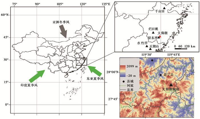
浙江省位于中国东南部,受到东亚季风气候的显著影响,是研究东亚夏季风演变过程及其区域响应的重要区域(图 1)。浙江省地形地貌为丘陵山地,受人类活动干扰较小的山地泥炭沼泽在浙江南部亚高山区域广泛发育。通过对该地区沼泽泥炭地沉积过程的研究,可以探索沼泽泥炭形成特征及其与区域其他泥炭发育过程的异同,从而加深对气候变化导致的区域沼泽泥炭地演化过程的了解。本文拟选择浙江省南部丽水市景宁县内的大仰湖沼泽泥炭地作为研究对象,通过AMS 14C测年方法,结合多指标分析,对大仰湖沼泽泥炭地的形成时间及其与亚洲夏季风强度变化间的关系进行研究。
|
图 1 浙江丽水景宁县大仰湖湿地位置 Fig. 1 Location of the Dayanghu wetland |
大仰湖沼泽泥炭地位于浙江省丽水市景宁畲族自治县大仰湖湿地群省级保护区内。保护区面积2304.4 hm2,地理坐标为27°50′37″~28°00′29 N″,119°39′25″~119°47′39″E;海拔613.8~1556.9 m。研究区位于浙东南构造侵蚀中低山区,属于洞宫山脉北段,华南褶皱系,主要是中生代火山岩、花岗岩和红色断陷盆地发育区,出露地层主要有震旦系变质岩、侏罗系火山岩、白垩系沉积岩和第四系松散沉积物[27]。地貌过程、气候变化和沉积作用共同塑造了研究区内的亚高山湿地群[28]。
区域气候属于亚热带季风气候,受东亚季风影响显著,同时夏季也受到西太平洋台风活动的影响。保护区内年均温为12 8 ℃,其中1月份平均温度2 8 ℃,7月份平均温度22.6 ℃,极端最低气温-14 ℃,无霜期196天左右,年日照时数1617.6 h,≥10 ℃年积温5493.5 ℃;年均降水量为1918 mm,年均相对湿度80 %以上[29]。保护区是瓯江水系发源地之一,水系呈树枝状,溪流多为间歇性,但由于植被覆盖率高,夏季强降水也不会产生洪水,而冬季地下水位依然维持在高位。
2 研究方法 2.1 样品采集与年代学分析2017年6月,利用荷兰Eijkelkamp公司生产的泥炭采样器(内径5 cm)在大仰湖沼泽泥炭地北部位置采集了3根连续的沼泽沉积岩芯,采样点位坐标为27°49′N,119°40′E(图 1);海拔1550 m;钻孔深度140 cm。在野外对岩芯进行了记录和描述,其中0~20 cm为含有丰富植物根系的棕黑色泥炭层;20~80 cm为棕黄色泥炭层,含少量植物根茎且偶见植物大化石;80 cm以下为粉砂质沉积物,部分层位可见小砾石,结合流域地形认为其属于河流相沉积物。在野外用保鲜膜将岩芯包裹置于PVC管中水平带回实验室,按照1 cm间隔进行分样,获取了140个连续沉积样品。对样品进行冷冻干燥并计算了各样品的干物质密度。
为避免沼泽沉积物中较年轻的植物根系物质污染[17],在挑选测年样品时避免了全样以及植物根系残体,选择不同深度的5个陆生植物大化石进行AMS 14C年代学测试。首先在体式显微镜下用超纯水将植物大化石表面附着的沉积物清洗干净,之后在真空烘箱内60 ℃条件下干燥6 h。干燥后的样品用锡箔纸包装完好,送到美国BETA放射性碳测年实验室进行测试,前处理方法采用酸-碱-酸(AAA)化学处理。处理后的样品烘干称重,放入封闭的石英管中进行燃烧。产生的CO2在铁催化剂的作用下与氢气反应,还原为石墨,之后进行测定。原始测年数据根据IntCal13曲线[30]进行日历年龄校正,校正过程利用CALIB 7.10软件(http://calib.org/calib/calib.html)进行。年代深度模型采用贝叶斯回归方法进行插值计算,在R软件[31]内利用Bacon 2.2程序[32]进行。
2.2 指标测试沉积物有机质含量采用烧失法获得。首先将坩埚编号并置于恒温烘箱105 ℃干燥2 h,在干燥皿中冷却后用电子天平称得其重量W0;将约10 ml冷冻干燥后的样品放入坩埚中,在105 ℃恒温箱中充分干燥,并在干燥皿中冷却至室温后对其称重,记为W105 ℃;将装有干样的坩埚放入马弗炉中,在550 ℃下烧5 h,充分去除有机质,待温度下降,取出坩埚后放入干燥皿中;待坩埚降到室温,将坩埚取出,用电子天平称量处理后坩埚与样品总重W550 ℃。烧失量(%)通过以下公式计算获得:

|
粒度组分分析采用英国Malvern公司生产的Mastersize 3000E激光粒度仪,测量范围为0.02~2000 μm,重复测量误差小于1 %。称取约0.3 g样品,加入10 ml浓度为10 %的稀盐酸(HCl)去除碳酸盐后,加入浓度为10 %的双氧水(H2O2)进行水浴加热以去除残留有机质,待充分反应后将烧杯注满蒸馏水浸泡24 h,抽掉蒸馏水。在重复浸泡和清洗使样品达到中性后,加入15 ml浓度为0.05 mol/L的六偏磷酸钠((NaPO3)6)溶液作为分散剂超声震荡10 min后上机测试,重复测试3次并取其平均值。对其中0~30 cm的样品进行了灰化处理,250 ℃下灰化3 h。
磁化率样品先经过冷冻干燥、压碎,之后放入特制的无磁性方形样品盒中(2 cm×2 cm×2 cm),并称取样品的净重。分别测试低频磁化率(Klf)和高频磁化率(Khf),经过质量归一化获得样品的质量磁化率。磁化率分析使用的仪器是英国Bartington公司生产的MS-2型便携式磁化率测量仪,所有结果均以相对SI标准表示。
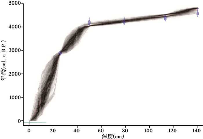
3 结果 3.1 年代-深度模型AMS 14C年代结果见表 1,随着深度增加埋藏年代递增,无年代倒置现象。底部年龄对应4585±68 cal.a B. P.,埋深50 cm处的植物大化石年代为4217±78 cal.a B. P.,自底部至50 cm深度处的沉积物年代只相差368~514 a。根据中间113~50 cm深度连续的年代学结果,认为大仰湖沼泽泥炭岩芯沉积过程是连续的。基于上述5个AMS 14C年代结果,对不同深度的年代进行插值后获得了约4800 cal.a B. P.以来的年代-深度模型(图 2)。大仰湖钻孔沉积速率表现出明显的阶段性变化,在4200 cal.a B. P.以前沉积速率较快,平均沉积速率为0.15 cm/a,而自4200 cal.a B. P.以来沉积速率则十分缓慢,平均沉积速率仅为0.013 cm/a。
| 表 1 大仰湖湿地岩芯AMS 14C年代结果 Table 1 AMS 14C results of the sediment samples from Dayanghu wetland core |
|
图 2 大仰湖湿地岩芯深度-年代模型 Fig. 2 Age-depth model of the Dayang wetland core |
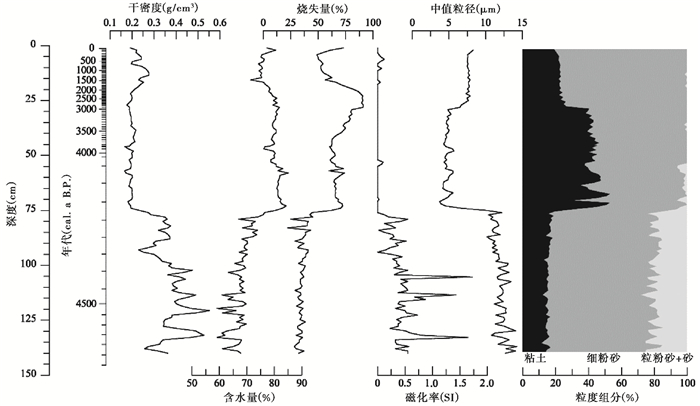
与大仰湖沼泽钻孔岩性变化呈现的阶段性类似,沉积物干密度、粒度参数、有机质含量、磁化率指标均显示出明显的阶段变化(图 3):
|
图 3 大仰湖湿地岩芯沉积物指标变化曲线 Fig. 3 Variation curves of sedimentary proxies from Dayanghu wetland core |
4800~4200 cal.a B. P.期间,沉积物平均干密度为0.37 g/cm3,平均含水率为68 %。沉积物以细粉砂(4~32 μm)为主,平均百分含量为65 %,粗粉砂(32~63 μm)和砂(>63 μm)平均含量分别为11 %和10 %,粘土平均含量(< μm)为15 %,平均中值粒径约为12 μm;沉积物烧失量相对稳定,平均值为35 %;磁化率值在呈现波动下降的趋势,平均值为0.45 SI。
在4200 cal.a B. P.前后,所有指标均发生了显著的变化。沉积物含水率增加至80 %左右,干密度由0.37 g/cm3降低至0.19 g/cm3;沉积物平均中值粒径由12 μm减小为4.5 μm,粒度组成中粗颗粒成分砂和粗粉砂含量显著降低,平均百分含量 < 1 %,细粉砂含量由63.5 %降低至49 %,粘土组分含量迅速增加,由18 %增加至50.3 %;沉积物烧失量显著升高,由44.4 %增加至72.4 %;磁化率值也显著降低。
自4200 cal.a B. P.以来,沉积物平均干密度为0.21 g/cm3;平均中值粒径为5.6 μm,粒度组分以细粉砂和粘土为主,平均百分含量分别为66.6 %和32.9 %;沉积物烧失量较高,平均值为68.3 %,磁化率接近0值。此外,依据粒度参数和烧失量数据,本阶段可划分出2个亚带,分别为4200~3100 cal.a B. P.和3100 cal.a B. P.至今。3100 cal.a B. P.以来相较于4200~3100 cal.a B. P.期间,沉积物中值粒径增大,平均值由4.8 μm增加至7.6 μm,细粉砂组分平均含量由56.5 %增加至76.7 %,粘土组分平均含量由42.6 %降低至23.1 %;烧失量在4200~3100 cal.a B. P.期间逐渐增加,但是在3100 cal.a B. P.以后开始逐渐降低。
4 讨论大仰湖沼泽钻孔岩性变化以及干物质密度、粒度组分、烧失量和磁化率等指标的变化指示了水体沼泽化的过程,显示沼泽泥炭累积始于4200 cal.a B. P.左右。沉积物粒度组成蕴含着物质来源及其过程信息[33~34],大仰湖钻孔底部沉积物中粗粉砂和砂组分含量较高,指示了较强的水动力环境,流域矿物质输入较多,对应于较高的沉积速率和磁化率值。在4200 cal.a B. P.前后,粒度组成的变化指示了水动力显著减弱,同时干密度、磁化率的降低表明外源物质输入显著减少。沉积物烧失量可以作为有机质含量的有效指标[35],大仰湖钻孔中的烧失量在4200 cal.a B. P.左右的升高,指示了有机质堆积量开始显著增加。4200 cal.a B. P.之后,粒度组成以粘土为主,铁磁性矿物减少,磁化率值显著降低,有机质含量显著增加,表明大仰湖泥炭地的沉积环境和物质来源与之前发生了明显变化,指示了沼泽泥炭地的形成。
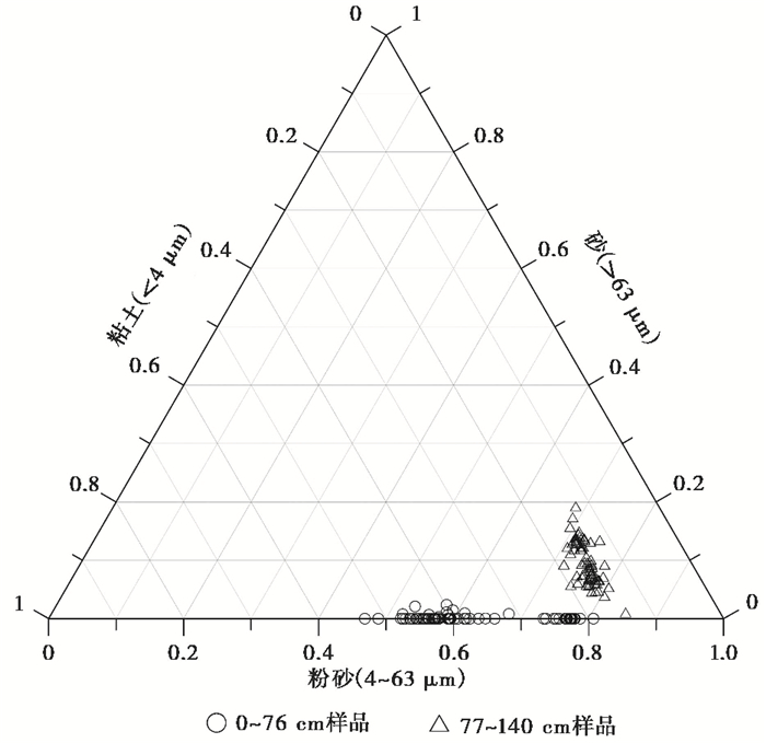
沼泽泥炭地的形成受到多种因素的控制,包括构造运动和气候因素等[1, 12, 36]。根据福建东北部现代监测资料[37],推测景宁地区的地壳垂直运动可能是缓慢下沉。由于地处华南褶皱系以及区域内具有构造断层存在[27],浙东南地区地震活动偶有发生。地震活动可能引起流域内岩石或者松散沉积物发生位移,有时阻塞河道引起沉积环境的改变。据中国地震台网资料(http://news.ceic.ac.cn),浙江省丽水地区于1574 A.D.发生过一次里氏5.5级的地震(震中位置27°36′N,119°6′E)。但是,此次地震事件并没有在大仰湖湿地及区域其他泥炭钻孔中有所记录。大仰湖湿地周边植被状况良好且周边山地坡度较小,无滑塌及滑坡风险,因此可排除地形地貌变化和构造运动对大仰湖沼泽泥炭形成发育的影响。浙江东南部邻近太平洋,夏季台风降水产生的洪水事件[38],可能影响山间溪流的沉积过程。大仰湖岩芯下部属于河流相沉积,砂含量平均为10 %,但是在岩芯上部层位,平均砂含量仅为0.2 % (图 4),说明强降水事件影响较弱。考虑到大仰湖湿地植被良好,对降水和径流的调蓄作用明显,强降水应不会引发瞬时洪水事件,结合区域内其他山地泥炭记录中并未发现洪积层位,基本可以排除洪水事件的影响。
|
图 4 大仰湖湿地岩芯沉积物粒度分布图 Fig. 4 The grain-size distributions of Dayanghu wetland sediments |
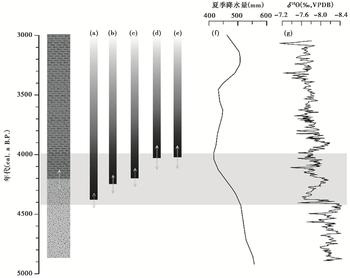
大仰湖沼泽泥炭地形成时间与区域内高山泥炭研究结果基本一致(图 5),包括福建戴云山[8, 19, 22]、福建天湖山[23]、福建水竹洋[39~40]、浙江烂田砚[21]、浙江天目山[7, 41]、江西井冈山[20]、江西大湖[42]、江西玉华山[43]等,均显示在4200 cal.a B. P.前后出现了新的泥炭层位或者沉积过程发生了显著变化。如福建中部戴云山莲花池泥炭底部埋藏于4400 cal.a B. P.[22],距离其较近的山间洼地内的另外一处泥炭DYS-2的底部埋藏年龄约为4250 cal.a B. P.[8];福建九仙山泥炭底部埋藏年龄为4230 cal.a B. P.[22];福建天湖山泥炭在4100 cal.a B. P.前后有机质含量突然明显增大[23]。浙江烂田砚泥炭沉积岩芯研究结果显示,在4600~4400 cal.a B. P.期间为明显的泥炭扩张时期[21]。浙江北部天目山千亩田泥炭记录显示,剖面115 cm深度处开始发育沼泽泥淤,对应年代约为4000 cal.a B. P.[7],天目山另一个泥炭钻孔在4300 cal.a B. P.左右发育了棕黑色泥炭[41]。大仰湖沼泽泥炭地的形成时间和区域其他山地泥炭的变化基本同步,说明4200 cal.a B. P.前后是区域山地沼泽泥炭形成的重要时期,且可能是由于区域气候环境变化导致。
|
图 5 大仰湖沼泽泥炭地和区域泥炭形成年代与东亚夏季风强度对比 (a)福建戴云山莲花池泥炭[22];(b)福建九仙山泥炭[22];(c)福建戴云山泥炭[8];(d)福建南屏天湖山泥炭[23];(e)浙江天目山千亩田泥炭[7];(f)浙江Xinjie剖面花粉定量重建的夏季降水量[45];(g)董哥洞氧同位素曲线[44];图中双向箭头代表年代误差 Fig. 5 Initiations of the Dayanghu marsh peat and other regional mountain peats, and their relations to the monsoonal precipitation. (a)Lianhuachi peat core[22]; (b)Jiuxianshan peat core[22]; (c)Daiyunshan peat core[8]; (d)Tianhushan peat core[23]; (e)Qianmutian peat core[7]; (f)Pollen-based summer precipitation reconstruction from Xinjie site[45]; (g)The δ18O from Dongge Cave[44]. The two-way arrows represent the age errors |
泥炭的形成和累积受到气候因素的显著控制,特定区域的泥炭是气候变化的产物[1]。与高纬度的泥炭发育受到温度变化影响不同,我国东部地区的山地泥炭发育和泥炭碳埋藏主要受到夏季太阳辐射和夏季风强度变化的控制[13],尤其是我国东部季风区的泥炭受到东亚夏季风变率的强烈影响[9, 14~15]。大仰湖湿地位于典型的东亚夏季风影响范围内(图 1),可以推测该点位泥炭地发育的原因是由于中全新世亚洲夏季风强度的变化。董哥洞石笋的δ18O记录显示,东亚夏季风在4000 cal.a B. P.前后显著减弱[44]。Lu等[45]以及Li等[46]利用花粉定量重建的全新世长江下游地区的夏季降水量变化过程,均发现在4000 cal.a B. P.前后存在降水突然减少的现象。同样,中国东南部泥炭花粉记录[18~22, 40]以及中国北方的气候重建记录[47~48]均显示了中全新世东亚夏季风突然减弱的证据。全新世早-中期,北半球太阳辐射较强,东亚夏季风较为强盛,我国东南部处于“全新世适宜期”,对应夏季高温多雨的气候特征[45~46]。与此相对应,我国东部的泥炭花粉记录显示,在8000~5000 cal.a B. P.期间亚热带和热带植被成分显著增加[18~22, 40]。大仰湖湿地钻孔下部沉积物以粉砂和砂为主,有机质含量较低,沉积速率快,对应于河流相沉积环境。此种环境下,较强的水动力条件限制了水生植物的生长。随着东亚夏季风在4200 cal.a B. P.前后突然减弱,区域季风降水减少,大仰湖湿地转变为水动力较弱的浅水沼泽环境,一方面有利于外源有机质的沉积,同时也有利于水生植物的生长。浙江和福建地区的山地泥炭中水生植物花粉含量在5000~4000 cal.a B. P.期间显著增加进一步支持了我们的推断[19, 21]。此外,同样位于浙江南部的望东垟湿地泥炭的花粉研究,揭示了区域内短暂存在的温带植物扩张,指示了区域温度的降低,同时湿地指示意义的植物花粉含量增加指示了区域水生植物的扩张[28]。由此可推断,4200 cal.a B. P.季风降水减少导致大仰湖湿地水动力显著减弱,水生植物开始扩张,水体沼泽化,进而导致了大仰湖沼泽泥炭地的发育。
5 结论本文基于浙江景宁大仰湖沼泽泥炭钻孔的沉积记录重建了该泥炭的发育过程,通过对比区域其他沼泽泥炭地沉积过程研究结果,探讨了区域性沼泽泥炭形成的关键时期及其主要驱动机制,主要结论如下:
(1) 大仰湖湿地钻孔沉积物始于4800 cal.a B. P.。钻孔沉积粒度组分、有机质含量以及磁学参数等的分析结果显示,钻孔下部沉积物颗粒较粗、磁化率较高且烧失量和含水率较低,表现为沉积速率较快的河流相沉积;而在4200 cal.a B. P.以后沉积环境发生了显著变化,粒度明显细化,磁化率很低,烧失量和含水率升高,沉积速率显著下降,指示了水体沼泽化的开始。
(2) 大仰湖沼泽泥炭地形成时间与中国东南部其他高山泥炭(如戴云山莲花池泥炭、九仙山泥炭、南屏天湖山泥炭、天目山千亩田泥炭等)研究结果基本一致,说明4500~4000 cal.a B. P.是区域山地泥炭开始形成的重要时期。
(3) 大仰湖沼泽泥炭地形成原因是由于区域气候变化,而非构造运动以及洪水事件引起的沉积环境改变。孢粉重建的夏季降水量和董哥洞的氧同位素均显示在4200 cal.a B. P.左右东亚夏季风减弱。夏季风降水减少导致大仰湖湿地水动力显著减弱,水生植物开始扩张,水体沼泽化加剧,进而形成了大仰湖沼泽泥炭地。
致谢: 感谢审稿专家和编辑部赵淑君老师建设性的修改意见。
| [1] |
柴岫. 泥炭地学[M]. 北京: 地质出版社, 1990: 1-90. Chai Xiu. Peat Geology[M]. Beijing: Geological Publishing House, 1990: 1-90. |
| [2] |
Charman D J, Beilman D W, Blaauw M, et al. Climate-related changes in peatland carbon accumulation during the last millennium[J]. Biogeosciences, 2013, 10: 929-944. DOI:10.5194/bg-10-929-2013 |
| [3] |
鲍锟山, 邢伟, 宋理洪, 等. 黑龙江流域湿地过去百年水位变化历史及驱动机制[J]. 第四纪研究, 2018, 38(4): 981-995. Bao Kunshan, Xing Wei, Song Lihong, et al. A 100-year history of water level change and driving mechanism in Heilongjiang River basin wetlands[J]. Quaternary Sciences, 2018, 38(4): 981-995. |
| [4] |
刘金亮, 尹希杰, 濮鸿雪, 等. 大九湖泥炭地现代植物不同组分的δ18O特征及其古气候意义[J]. 第四纪研究, 2018, 38(4): 1024-1034. Liu Jinliang, Yin Xijie, Pu Hongxue, et al. Characteristics of δ18O of the different components of plants and it's climatic significance in the Dajiuhu peatbog, Central China[J]. Quaternary Sciences, 2018, 38(4): 1024-1034. |
| [5] |
Yue Y, Zheng Z, Huang K, et al. A continuous record of vegetation and climate change over the past 50, 000 years in the Fujian Province of eastern subtropical China[J]. Palaeogeography, Palaeoclimatology, Palaeoecology, 2012, 365-366(9): 115-123. |
| [6] |
Zhang W, Yan H, Cheng P, et al. Peatland development and climate changes in the Dajiuhu basin, Central China, over the last 14, 100 years[J]. Quaternary International, 2016, 425: 273-281. DOI:10.1016/j.quaint.2016.06.039 |
| [7] |
Ma C M, Cheng Z, Zheng C G, et al. Climate changes in East China since the late-glacial inferred from high-resolution mountain peat humification records[J]. Science in China(Series D), 2009, 52(1): 118-131. DOI:10.1007/s11430-009-0003-5 |
| [8] |
Zhao L, Ma C, Tang L, et al. Investigation of peat sediments from Daiyun Mountain in Southeast China:Late Holocene vegetation, climate and human impact[J]. Vegetation History and Archaeobotany, 2016, 25(4): 359-373. DOI:10.1007/s00334-016-0554-2 |
| [9] |
Zhang Z, Liu K B, Bianchette T A, et al. The mid-Holocene decline of the East Asian summer monsoon indicated by a lake-to-wetland transition in the Sanjiang Plain, Northeast China[J]. The Holocene, 2018, 28(2): 246-253. DOI:10.1177/0959683617721321 |
| [10] |
Jones M C, Yu Z. Rapid deglacial and Early Holocene expansion of peatlands in Alaska[J]. Proceedings of the National Academy of Sciences of the United States of America, 2010, 107(16): 7347-7352. DOI:10.1073/pnas.0911387107 |
| [11] |
Yu Z C, Loisel J, Brosseau D P, et al. Global peatland dynamics since the Last Glacial Maximum[J]. Geophysical Research Letters, 2010, 37(13): 69-73. |
| [12] |
Loisel J, Bellen S V, Pelletier L, et al. Insights and issues with estimating northern peatland carbon stocks and fluxes since the Last Glacial Maximum[J]. Earth-Science Reviews, 2017, 165: 59-80. DOI:10.1016/j.earscirev.2016.12.001 |
| [13] |
Zhao Y, Yu Z, Tang Y, et al. Peatland initiation and carbon accumulation in China over the last 50, 000 years[J]. Earth-Science Reviews, 2014, 128: 139-146. DOI:10.1016/j.earscirev.2013.11.003 |
| [14] |
Xing W, Bao K, Guo W, et al. Peatland initiation and carbon dynamics in northeast China:Links to Holocene climate variability[J]. Boreas, 2015, 44(3): 575-587. DOI:10.1111/bor.12116 |
| [15] |
Liu X, Lu R, Du J, et al. Evolution of peatlands in the Mu Us Desert, Northern China, since the last deglaciation[J]. Journal of Geophysical Research:Earth Surface, 2018, 123(2): 252-261. DOI:10.1002/2017JF004413 |
| [16] |
贾飞飞, 鲁瑞洁, 高尚玉. 毛乌素沙漠东南缘湖沼相沉积物粒度特征记录的12.2 cal.ka B. P.以来的区域环境变化[J]. 第四纪研究, 2018, 38(5): 1211-1220. Jia Feifei, Lu Ruijie, Gao Shangyu. Environmental changes recorded from grain-size characteristics of the lacustrine-peat sediments from southeastern margin of Mu Us Desert since 12.2 cal. ka B. P.[J]. Quaternary Sciences, 2018, 38(5): 1211-1220. |
| [17] |
周卫健, 卢雪峰, 武振坤, 等. 若尔盖高原全新世气候变化的泥炭记录与加速器放射性碳测年[J]. 科学通报, 2001, 46(12): 1040-1044. Zhou Weijian, Lu Xuefeng, Wu Zhenkun, et al. Peat record reflecting Holocene climatic change in the Zoigê Plateau and AMS radiocarbon dating[J]. Chinese Science Bulletin, 2001, 46(12): 1040-1044. DOI:10.3321/j.issn:0023-074X.2001.12.018 |
| [18] |
Zhou W, Xie S, Meyers P A, et al. Reconstruction of Late Glacial and Holocene climate evolution in Southern China from geolipids and pollen in the Dingnan peat sequence[J]. Organic Geochemistry, 2005, 36(9): 1272-1284. DOI:10.1016/j.orggeochem.2005.04.005 |
| [19] |
Zhao L, Ma C, Leipe C, et al. Holocene vegetation dynamics in response to climate change and human activities derived from pollen and charcoal records from Southeastern China[J]. Palaeogeography, Palaeoclimatology, Palaeoecology, 2017, 485: 644-660. DOI:10.1016/j.palaeo.2017.06.035 |
| [20] |
Huang K, Zheng Z, Liao W, et al. Reconstructing Late Holocene vegetation and fire histories in monsoonal region of Southeastern China[J]. Palaeogeography, Palaeoclimatology, Palaeoecology, 2014, 393: 102-110. DOI:10.1016/j.palaeo.2013.11.005 |
| [21] |
Ma T, Tarasov P E, Zheng Z, et al. Pollen-and charcoal-based evidence for climatic and human impact on vegetation in the northern edge of Wuyi Mountains, China, during the last 8200 years[J]. The Holocene, 2016, 26(10): 1616-1626. DOI:10.1177/0959683616641744 |
| [22] |
Qiu H L. A 4000-year pollen record of vegetation change from the subtropical mountains of Fujian Province, China[J]. Journal of Subtropical Resources and Environment, 2006, 1(1): 11-23. |
| [23] |
胡凡根, 李志忠, 姜修洋, 等. 福建屏南天湖山泥炭腐殖化度记录的早全新世以来气候变化[J]. 亚热带资源与环境学报, 2011, 6(3): 31-39. Hu Fangen, Li Zhizhong, Jiang Xiuyang, et al. Holocene climate change recorded in peat humification on Tianhu Mountain in northern Fujian Province[J]. Journal of Subtropical Resources and Environment, 2011, 6(3): 31-39. DOI:10.3969/j.issn.1673-7105.2011.03.007 |
| [24] |
周云鹏, 胡忠行, 张曼, 等. 浙江望东垟亚高山沼泽泥炭磁性特征及其环境意义[J]. 第四纪研究, 2017, 37(6): 1348-1356. Zhou Yunpeng, Hu Zhongxing, Zhang Man, et al. Magnetic properties of the Wangdongyang subalpine peatland in Zhejiang Province, Eastern China and its paleoenvironmental implications[J]. Quaternary Sciences, 2017, 37(6): 1348-1356. |
| [25] |
牛蕊, 周立旻, 孟庆浩, 等. 贵州草海南屯泥炭记录的中全新世以来的气候变化[J]. 第四纪研究, 2017, 37(6): 1357-1369. Niu Rui, Zhou Limin, Meng Qinghao, et al. The paleoclimate variations of the Nantun peat in the Caohai area since the Middle Holocene[J]. Quaternary Sciences, 2017, 37(6): 1357-1369. |
| [26] |
伦子健, 顾延生, 刘红叶, 等. 神农架大九湖湿地表土植硅体记录及其环境意义[J]. 第四纪研究, 2016, 36(3): 656-665. Lun Zijian, Gu Yansheng, Liu Hongye, et al. Phytolith records in the surface soils of Dajiuhu wetland and their environmental significance, Shennongjia Mountains[J]. Quaternary Sciences, 2016, 36(3): 656-665. |
| [27] |
浙江省地质矿产局. 浙江省区域地质志[M]. 北京: 地质出版社, 1989: 10-50. Bureau of Geology and Mineral Resources of Zhejiang Province. Regional Geology of Zhejiang Province[M]. Beijing: Geological Publishing House, 1989: 10-50. |
| [28] |
顾延生, 唐倩倩, 刘红叶, 等. 浙江景宁亚高山湿地群形成环境探究[J]. 湿地科学, 2016, 14(3): 302-310. Gu Yansheng, Tang Qianqian, Liu Hongye, et al. Formation environment of the subalpine wetlands in Jingning She Autonomous County, Zhejiang Province[J]. Wetland Science, 2016, 14(3): 302-310. |
| [29] |
刘日林, 叶文晶, 徐端妙, 等. 景宁望东垟、大仰湖自然保护区种子植物区系分析[J]. 浙江林业科技, 2017, 37(3): 9-16. Liu Rilin, Ye Wenjing, Xu Duanmiao, et al. Flora of seed plants in Wangdongyang and Dayanghu nature reserve of Jingning[J]. Journal of Zhejiang Forest Science and Technology, 2017, 37(3): 9-16. DOI:10.3969/j.issn.1001-3776.2017.03.002 |
| [30] |
Reimer P J, Bard E, Bayliss A, et al. IntCal13 and Marine13 radiocarbon age calibration curves 0-50, 000 years cal BP[J]. Radiocarbon, 2013, 55(4): 1869-1887. DOI:10.2458/azu_js_rc.55.16947 |
| [31] |
R Core Team. R: A language and environment for statistical computing. R foundation for statistical computing[CP]. Vienna, Austria, 2016, URL: https://www.R-project.org/.
|
| [32] |
Blaauw M, Christen J A. Flexible paleoclimate age-depth models using an autoregressive gamma process[J]. Bayesian Analysis, 2011, 6(3): 457-474. |
| [33] |
秦亚超. 南黄海西部日照至连云港海域表层沉积物粒度特征及其指示意义[J]. 第四纪研究, 2017, 37(6): 1412-1428. Qin Yachao. Grain-size characteristics of bottom sediments and its implications offshore between Rizhao and Lianyungang in the western South Yellow Sea[J]. Quaternary Sciences, 2017, 37(6): 1412-1428. |
| [34] |
叶远达, 徐海, 蓝江湖, 等. 云南程海沉积物粒度对水深的指示意义[J]. 第四纪研究, 2018, 38(4): 1007-1016. Ye Yuanda, Xu Hai, Lan Jianghu, et al. Sedimentary grain size at Lake Chenghai, Yunnan Province:Indicator for water depth[J]. Quaternary Sciences, 2018, 38(4): 1007-1016. |
| [35] |
Meyers P A. Applications of organic geochemistry to paleolimnological reconstructions:A summary of examples from the Laurentian Great Lakes[J]. Organic geochemistry, 2003, 34(2): 261-289. DOI:10.1016/S0146-6380(02)00168-7 |
| [36] |
Lottes A L, Ziegler A M. World peat occurrence and the seasonality of climate and vegetation[J]. Palaeogeography, Palaeoclimatology, Palaeoecology, 1994, 106(1-4): 23-37. DOI:10.1016/0031-0182(94)90003-5 |
| [37] |
刘与锟, 郭逢英, 陈兆煌, 等. 福建省现代地壳垂直运动与断裂活动[J]. 地壳形变与地震, 1998, 18(4): 68-73. Liu Yukun, Guo Fengying, Chen Zhaohuang, et al. Recent crustal vertical movement and fault activity of Fujian Province[J]. Crustal Deformation and Earthquake, 1998, 18(4): 68-73. |
| [38] |
王咏梅, 任福民, 李维京, 等. 中国台风降水的气候特征[J]. 热带气象学报, 2008, 24(3): 233-238. Wang Yongmei, Ren Fumin, Li Weijing, et al. Climatic characteristics of typhoon precipitation over China[J]. Journal of Tropical Meteorology, 2008, 24(3): 233-238. DOI:10.3969/j.issn.1004-4965.2008.03.004 |
| [39] |
Wang M, Zheng Z, Man M, et al. Branched GDGT-based paleotemperature reconstruction of the last 30, 000 years in humid monsoon region of Southeast China[J]. Chemical Geology, 2017, 463: 94-102. DOI:10.1016/j.chemgeo.2017.05.014 |
| [40] |
Yue Y, Zheng Z, Huang K, et al. A continuous record of vegetation and climate change over the past 50, 000 years in the Fujian Province of eastern subtropical China[J]. Palaeogeography, Palaeoclimatology, Palaeoecology, 2012, 365-366: 115-123. DOI:10.1016/j.palaeo.2012.09.018 |
| [41] |
张愈, 马春梅, 赵宁, 等. 浙江天目山千亩田泥炭晚全新世以来Rb/Sr记录的干湿变化[J]. 地层学杂志, 2015, 39(1): 97-107. Zhang Yu, Ma Chunmei, Zhao Ning, et al. Late Holocene Rb/Sr ratios as a paleoclimate proxy in the Qianmutian peat of Tianmu Mountains, Zhejiang Province[J]. Journal of Stratigraphy, 2015, 39(1): 97-107. |
| [42] |
薛积彬, 钟巍, 彭晓莹, 等. 南岭东部大湖泥炭沉积记录的古气候[J]. 海洋地质与第四纪地质, 2007, 27(5): 105-113. Xue Jibin, Zhong Wei, Peng Xiaoying, et al. Paleo-climate significance for the past 12 ka BP revealed by Dahu peat record in the eastern South Mountain[J]. Marine Geology & Quaternary Geology, 2007, 27(5): 105-113. |
| [43] |
李亮, 马春梅, 鹿化煜, 等. 江西中部玉华山沼泽泥炭记录的过去两千年气候变化初步研究[J]. 第四纪研究, 2017, 37(3): 548-559. Li Liang, Ma Chunmei, Lu Huayu, et al. A preliminary study of the climate change since 2 ka archived by a peat core from Yuhua Mountain in the middle Jiangxi Province[J]. Quaternary Sciences, 2017, 37(3): 548-559. |
| [44] |
Wang Y, Cheng H, Edwards R L, et al. The Holocene Asian monsoon:Links to solar changes and North Atlantic climate[J]. Science, 2005, 308(5723): 854-857. DOI:10.1126/science.1106296 |
| [45] |
Lu F, Ma C, Zhu C, et al. Variability of East Asian summer monsoon precipitation during the Holocene and possible forcing mechanisms[J]. Climate Dynamics, 2019, 52(1-2): 969-989. DOI:10.1007/s00382-018-4175-6 |
| [46] |
Li J, Dodson J, Yan H, et al. Quantitative Holocene climatic reconstructions for the lower Yangtze region of China[J]. Climate Dynamics, 2018, 50(3-4): 1101-1113. DOI:10.1007/s00382-017-3664-3 |
| [47] |
Chen F, Xu Q, Chen J, et al. East Asian summer monsoon precipitation variability since the last deglaciation[J]. Scientific Reports, 2015, 5: 11186. DOI:10.1038/srep11186 |
| [48] |
Wen R, Xiao J, Fan J, et al. Pollen evidence for a mid-Holocene East Asian summer monsoon maximum in Northern China[J]. Quaternary Science Reviews, 2017, 176: 29-35. DOI:10.1016/j.quascirev.2017.10.008 |
2 Bureau of Dayang Wetland Nature Reserve, Jingning 323500, Zhejiang)
Abstract
Climate change in the Holocene is closely related to the development of mash peat. Study the initiation of peatland and its relative climatic controls will provide a better understanding of the fate of peatland in the future climate scenario. Zhejiang Province (Southeastern China) is strongly influenced by the East Asian Summer Monsoon, and mountain peats have been widely developed in the southern part. In this paper, we aim to study the initiation of Dayanghu marsh peat from Dayanghu Wetland Reserve (27°50'37"~28°00'29 N", 119°39'25"~119°47'39"E; 613.8~1556.9 m a.s.l.), Jingning County, Zhejiang Province, by using the AMS 14C technique and analyzing the sedimentary grain size, organic matter content and magnetic susceptibility of 140 samples from a 1.4-m core. Additionally, we try to reveal the climatic controls of the initiation of Dayanghu marsh peat in the mid-Holocene, based on comparisons with regional peat records and other paleoclimatic records relating to the East Asian Summer Monsoon. The age model shows that the basal age of the Dayanghu sediment is about 4800 cal.a B. P., and the initiation of the marsh peat is around 4200 cal.a B. P. The variations of grain-size components, organic matter content and magnetic susceptibility also reflect a significant change from fluvial to marsh environments right around this time. The initiation of Dayanghu marsh peat is roughly consistent with the formation of regional alpine peat, indicating that 4500~4000 cal.a B. P. is an important period for the initiation of regional mountain peats. Based on paleoclimatic background revealed by previous researches, we suggest that the variabilities of East Asian Summer Monsoon was the main driver for Dayanghu marsh peat formation. The monsoonal precipitation reduced significantly around 4200 cal.a B. P., leading to negative water balance in the study region. The consequential drop in water level and reduced hydrodynamics during this period triggered the expansion of aquatic plants. These processes finally allowed the initiation and accumulation of the marsh peat in the Dayanghu wetland. 2019, Vol.39

