2 中国科学院大学, 北京 100049)
泥炭作为植物残体在无氧环境下积累与缓慢分解的产物,其形成与发育主要受到植被、土壤水分和温度及其不同水热组合等因素的影响[1]。泥炭沉积可以提供多种指示意义明确的古环境代用指标记录,且具有年代控制与连续性好、分辨率高等优势,因而在古气候研究中得到了广泛的应用[2~9]。
青藏高原东部的若尔盖盆地分布有我国面积最大的高山沼泽湿地,是我国泥炭的主要分布区之一[10]。近年来,诸多学者在若尔盖盆地利用泥炭沉积开展了全新世泥炭地发育、气候与植被变化的多指标记录研究。若尔盖盆地多个泥炭沉积的底界年龄测定显示,其泥炭地最早于早全新世(约11 ka,即1 ka=1000 a B.P.)开始发育[11~14]。已有的地球化学指标、同位素与孢粉组合等记录揭示出全新世若尔盖盆地区域尺度植被与气候变化的趋势表现为“季风模态”,即从早、中全新世气候暖湿适宜,之后趋向冷干;期间发生的多期次千年-百年尺度的植被、气候快速变化可以与北大西洋浮冰事件相对应,可能反映了全新世高纬地区温度异常对若尔盖地区的环境影响[11~15]。
青藏高原东部若尔盖盆地已有的研究基于单点记录为主,忽略了地形地貌因素对泥炭地发育的可能影响[16]。部分泥炭古气候记录揭示的气候突变事件在变化幅度上与北大西洋地区温度异常的记录并不匹配[11],如诸多地区表现显著的8.2 ka气候事件在若尔盖地区却较微弱[14~15, 17]。最近,青藏高原全新世植被变化的集成研究和若尔盖古植物多样性的研究发现,高原植被对不同气候要素的响应可能存在“阈值效应”与“滞后效应”[18~20];那么,若尔盖盆地植被与气候因素共同控制下的泥炭发育也可能存在着对不同气候要素如温度、降水的不同响应。
本研究基于青藏高原东部若尔盖盆地泥炭沉积核心区具有一定空间展布的3支泥炭钻孔[13, 15, 21],通过高分辨率的测年数据与同一年代模型建立可对比的高精度的年代-深度模式,利用高分辨率的泥炭性质指标记录及其时间序列分析结果,探讨全新世泥炭发育对不同气候驱动力的响应及其记录的气候突变事件。
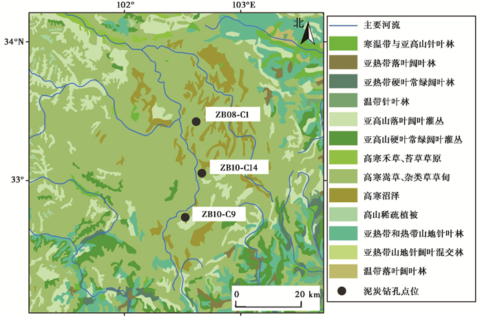
1 材料与方法 1.1 泥炭钻孔与测年若尔盖盆地(32°10′~34°10′N,101°45′~103°25′E;3400~3600 m a.s.l.)位于青藏高原东部,年均降水量约648.5 mm,年均温1.1 ℃[13]。若尔盖地区位于高寒草甸植被带,本区泥炭地多发育木里苔草(Carex muliensis)和矮蒿草(Kobresia humilis)沼泽草甸植被。在盆地周边海拔3400~3800 m的高山缓坡上分布有主要由四川蒿草(K.setchwanensis)、垂穗披碱草(Elymus nutans)、草地早熟禾(Poa partensis)等组成的高山草甸;海拔4000 m以上分布有山地针阔叶混交林和山地针叶林,主要由云杉(Picea asperata)、青杄(P.wilsonii)、紫果云杉(P. purpurea)、岷江冷杉(Abies faxoniana)、高山松(Pinus densata)、白桦(Betula platyphylla)以及辽东栎(Quercus liaotunggensis)等组成[22](图 1)。
|
图 1 青藏高原东部若尔盖泥炭钻孔位置与植被状况[22] Fig. 1 Vegetation map of the Zoigé Basin(eastern Tibetan Plateau)[22] and locations of studied peat cores |
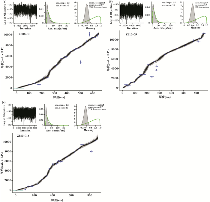
2008年和2010年,研究团队陆续在若尔盖盆地泥炭分布核心区钻取了3支透底泥炭钻孔,分别为ZB08-C1(长6.5 m;33°27′N,102°38′E;海拔3467 m a.s.l.)[13]、ZB10-C9 (6.68 m;32°47′N,102°31′E;3507 m a.s.l.)[21]和ZB10-C14 (8.9 m;33°06′N,102°40′E;海拔3470 m a.s.l.)[15](图 1)。本研究采用的3支钻孔AMS14 C年代数据分别有19个、20个和20个,测年材料为不同层位挑取的莎草科植物叶片和大炭屑颗粒。对不同钻孔年代数据校正使用的年代校正数据库为IntCal13[23],并一致采用贝叶斯年代-深度模型(Bacon)建立可对比的年代-深度模式[24]。
1.2 烧失量分析烧失量分析基于不同高温燃烧之后样品重量的变化对其有机质损失量(loss-on-ignition,简称LOI)进行测定[25~26],进而指示环境和气候的变化[27~28]。泥炭沉积物的容重指标可以指示其紧实程度和矿物质、有机质的相对比例;其有机质含量(organic matter content)和有机质干密度指标(ash-free bulk density)可指示其来源植被的生产力、形成时期的气候条件与保存情况等[13]。一般来说,泥炭沉积物的矿物含量与容重均低于湖相沉积物;气候暖湿背景下形成的泥炭具有较低的容重与较高的产量、有机质含量和有机质干密度[29]。泥炭沉积物的碳酸盐和硅酸盐类矿物的含量与其有机质含量呈反向变化,其来源主要为沉积过程自生碳酸盐和风力搬运的外源物质[13, 29]。因此本研究主要利用有机质含量和有机质干密度等指标来开展泥炭发育、气候变化及其时间序列的分析。
本研究采用的数据均基于以下的烧失量实验分析流程[30]:1)按照1~2 cm深度间距取1~2 cm3体积的样品,本研究的3支钻孔用于烧失量分析的样品数分别为565个、698个和815个;2)在105 ℃条件下,去除泥炭样品的水分,称重后计算获得含水率数据;3)在550 ℃高温下,去除样品有机质,称重后可计算获得有机质含量及其干密度数据;4)在1000 ℃条件下高温煅烧,分解碳酸盐矿物,称重后经过换算可得到碳酸盐含量和硅酸盐类残渣的含量。
1.3 泥炭性质指标记录的时间序列分析本研究将3个泥炭钻孔的泥炭性质指标记录按照20年间距插值、取平均值构成集成记录,并利用Redfit红噪音频谱分析方法来确定频谱分析峰值所表征的准周期成分[31];其中,我们选用了1000次蒙特卡罗拟合与Welch取样窗函数,并基于90 %和95 %置信线显示不同周期特征的显著性。
研究进一步对泥炭性质指标集成记录进行20年分辨率插值、去均值和去趋势,进而基于连续小波变换(Continuous Wavelet Analysis,简称CWT)进行了小波分析。小波分析将时间序列的时域-频域分解,分析周期及其频率振幅随时间的变化,揭示泥炭性质时间序列的周期随时间的变化特征[32~33]。分析采用蒙特卡罗方法[33]计算并检验符合χ2分布的95 %置信线,从而给出95 %的置信区间;同时还标定了序列功率谱的边缘效应影响区(Cone of Influence,简称COI)。Redfit频谱分析和小波分析采用了软件Matlab2016[34]。
2 结果 2.1 年代若尔盖泥炭钻孔的年代-深度模式显示,钻孔底部年龄分别为10210 cal.a B. P.(ZB08-C1孔)、11887 cal.a B. P.(ZB10-C9孔)和10550 cal.a B. P.(ZB10-C14孔)(图 2)。依据年代结果,烧失量分析的样品平均时间分辨率达到约20年,在后续研究中被插值到百年时间分辨率上进行了气候变化重建与时间序列分析。
|
图 2 若尔盖盆地泥炭钻孔年代-深度模式 (a)ZB08-C1孔(原始数据来自Zhao等[13]);(b)ZB10-C9孔(原始数据来自李焕[21]);(c)ZB10-C14孔(原始数据来自Sun等[15]) Fig. 2 Age-depth models for three peat cores in the Zoigé Basin. (a)Core ZB08-C1(raw chronological data from Zhao et al. [13]); (b)Core ZB10-C9(raw data from Li[21]); (c)Core ZB10-C14(raw data from Sun et al. [15]) |
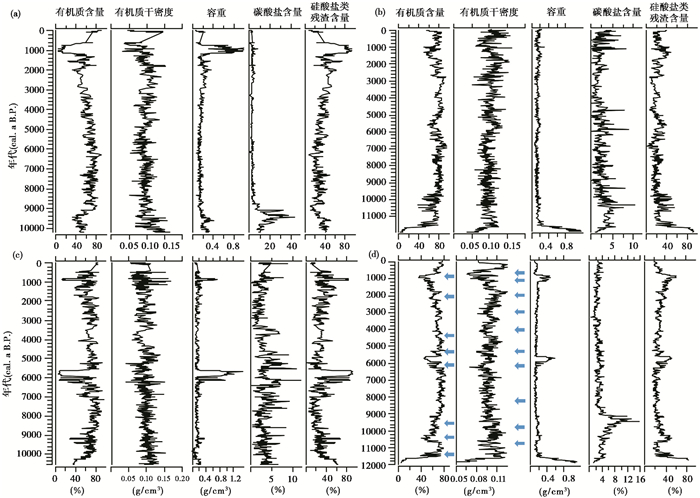
若尔盖盆地泥炭钻孔沉积物的烧失量分析结果显示,在盆地泥炭分布核心区,其泥炭地形成(有机质含量>50 %)分别起始于约9.3 ka(ZB08-C1)、11.5 ka(ZB10-C9)和10.3 ka(ZB10-C14)(图 3)。
|
图 3 若尔盖泥炭钻孔烧失量分析结果(原始数据来自Zhao等[13]、李焕[21]和Sun等[15]) (a)ZB08-C1孔;(b)ZB10-C9孔;(c)ZB10-C14孔;(d)3支钻孔集成数据序列,灰色箭头表示指标记录的快速变化 Fig. 3 Results of Loss-on-Ignition analysis on three peat cores in the Zoigé Basin(raw data from Zhao et al. [13], Li[21], and Sun et al. [15]). (a)Core ZB08-C1; (b)Core ZB10-C9; (c)Core ZB10-C14; (d)The integrated proxy sequences of three peat cores and the gray-colored arrows indicating the abrupt changes |
若尔盖盆地泥炭性质指标变化序列显示,钻孔底部湖相沉积物的硅酸盐类残渣含量(24.7 % ~95.7 %,平均58.3 %)、碳酸盐含量(平均10.6 %)和容重(平均0.42 g/cm3,最大值1.17 g/cm3)较高,而有机质含量(34.2 %)较低,并出现了有机质干密度的极低值(0.03 g/cm3);其上覆的泥炭沉积物则表现为较高的有机质含量(平均68.4 %,最大值96.7 %)和有机质干密度(平均0.11 g/cm3,最大值0.17 g/cm3),较低的碳酸盐含量(3.1 %)、硅酸盐类残渣含量(29.6 %)和容重(平均0.17 g/cm3,最小值0.04 g/cm3)(图 3)。
泥炭性质指标集成序列显示(图 3d),泥炭沉积物的有机质含量变化范围在4.9 % ~83.6 % (平均66.3 %),有机质干密度值变化范围则在0.04~0.17 g/cm3(平均0.10 g/cm3)。二者表现出从约11.5~10.0 ka至6 ka维持了较高(图 3d),指示了泥炭地在早中全新世高度发育,在6 ka以后逐渐下降;在6.1~5.6 ka期间当地泥炭沉积一度减缓,盆地北部的泥炭沉积中矿物含量明显增高(图 3a),盆地南部则发育了湖相沉积薄层[15](图 3b和3c);晚全新世泥炭性质指标在较大波动中逐渐下降,指示了晚全新世泥炭地发育逐渐变缓,有机质干密度在0.9~0.6 ka一度降至极低值区间(图 3d)。根据不同钻孔泥炭性质指标集成曲线的变化,其百年尺度上的显著降低出现于约11.2 ka、10.6~10.3 ka、9.6~9.4 ka、6.3~6.1 ka、5.5~5.3 ka、4.3~3.8 ka、3.1~2.8 ka、2.1 ka、1.6~1.4 ka和0.9~0.6 ka时段(图 3d、图 4a和4b)。
|
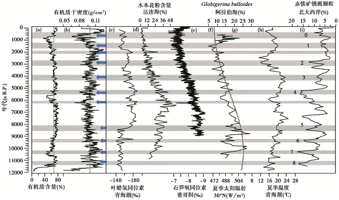
图 4 若尔盖泥炭性质指标序列揭示的气候突变事件及与大区域古气候记录的对比 (a)和(b)若尔盖有机质含量和有机质干密度集成记录曲线,灰色箭头及其长短表示主要的气候突变事件及其变幅差异;(c)青海湖沉积物叶蜡氢同位素记录[36];(d)达连海木本花粉含量[37];(e)董哥洞石笋氧同素记录[38];(f) 30°N夏季太阳辐射[39](灰色粗线);(g)阿拉伯海浮游有孔虫Globigerina bulloides含量[40];(h)青海湖沉积物U37K记录估算的夏季温度变化[41];(i)北大西洋冰筏沉积记录[42],其中数字表示冰筏事件期次;灰色条带标注了气候突变事件的对比 Fig. 4 Abrupt climatic changes inferred by multi-proxy sequences of peat formation history in the Zoigé Basin and their correlation with other regional paleoclimate records. (a)and (b) Integrated curves of organic matter content and ash-free bulk density recorded in three peat cores of the Zoigé Basin, respectively. While length variations in gray-colored arrows indicated the different amplitudes in the abrupt climate changes; (c)Leaf wax hydrogen isotope record in Qinghai Lake[36]; (d)Arboreal pollen content in Dalianhai[37]; (e)Oxygen isotope record in Dongge Cave[38]; (f)Summer insolation at 30°N [39](gray curve); (g)Fossil Globigerina bulloides record in the Arabian Sea[40]; (h)Summer temperature changes inferred by the U37K record in Qinghai Lake[41]; (i)Stack of drift ice records in the North Atlantic[42], with numbers marking the ice-rafted debris events. Horizontal grey bars highlighted a series of abrupt climatic changes |
若尔盖盆地泥炭沉积核心区3个具有精确年代控制与高分辨率的泥炭指标序列反映了青藏高原东部全新世泥炭发育历史与气候变化过程。指标记录显示,若尔盖盆地泥炭分布核心区,其泥炭地的形成最早始于早全新世约11.5 ka[11, 15, 19, 35]。泥炭有机质含量、有机质干密度等指标记录了当地早、中全新世11.5~6.0 ka泥炭发育繁盛,这指示了若尔盖盆地早、中全新世气候暖湿适宜[13~15];之后至晚全新世期间,泥炭发育过程频繁波动并逐渐变缓,反映了气候条件在波动中趋向于冷干,其中泥炭沉积物的有机质含量在0.9~0.6 ka时段显著降低,而容重指标和矿物含量显著增高(图 3、图 4a和4b),这可能指示了当地小冰期气候的变冷致使泥炭发育明显减弱;之后,伴随气候温度等条件的回升,泥炭发育迅速恢复(图 4a和4b)。
将若尔盖盆地烧失量指标与青藏高原东北部青海湖全新世降水变化(叶蜡氢同位素记录)[36]、邻近地区达连海的木本花粉含量变化[37]、中国东部董哥洞石笋氧同位素记录[38]、全新世北纬30°的夏季太阳辐射变化[39]、阿拉伯海浮游有孔虫记录的印度季风变化[40]、青海湖全新世U37K记录定量重建的夏季温度变化[41]、北大西洋冰筏沉积记录的温度异常[42]等大区域古气候记录进行对比。结果发现若尔盖泥炭指标记录的全新世泥炭地发育趋势与夏季太阳辐射[39]及其主控的气候温度[37]变化趋势较为一致,在千年尺度突变的发生时间和幅度上则可与季风突然减弱[40]与气候变冷事件[41~42]能很好地对应。这反映了在太阳辐射与温度变化对青藏高原东部全新世气候与泥炭发育的主要驱动之上,叠加了季风降水与北半球高纬温度异常的调制作用。
结合若尔盖盆地泥炭指标序列与不同地区全新世温度与降水突变序列(图 3和图 4),青藏高原东部泥炭发育快速变缓的时段(如11.2 ka、10.6~10.3 ka、9.6~9.4 ka和1.6~1.4 ka),气候相对冷干;而在其他泥炭发育快速、大幅变缓的时段(6.3~6.1 ka、5.5~5.3 ka、4.3~3.8 ka、3.1~2.8 ka、2.1 ka和0.9~0.6 ka)气候相对冷湿(图 4)。
其中,早全新世至中全新世约6.5 ka期间,若尔盖盆地泥炭发育指标如有机质干密度等变幅明显小于之后的时段,显示出该时期泥炭发育过程对北半球高纬温度异常响应的敏感程度弱于自6.5 ka至晚全新世的响应过程(图 4b)。特别是北半球大部分地区广泛发生的8.2 ka气候变冷事件[38, 42~44],在若尔盖盆地泥炭发育与植被变化记录中的表现却较为微弱[15, 17];而若尔盖泥炭记录揭示的4.3~3.8 ka、4.2 ka、3.1~2.8 ka、0.9~0.6 ka时段气候冷湿突变事件,在变化幅度与持续时间上与诸多记录中的4.2 ka、2.8 ka与小冰期气候突变具有很好的一致性[38, 42, 44~47](图 4)。这些现象可能反映了在季风降水较充沛、温度条件较好的早、中全新世,青藏高原东部泥炭地发育较快;在季风降水与温度显著减弱的晚全新世,北半球高纬地区温度异常对高原东部气候与泥炭地发育的影响更为显著。
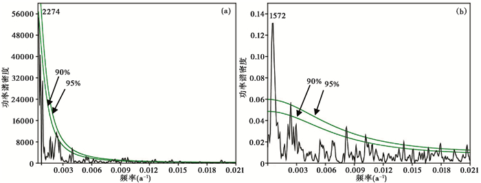
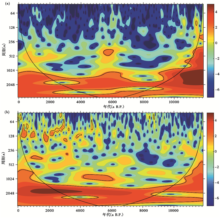
3.2 青藏高原东部泥炭发育历史与气候变化的周期性特征为了检验青藏高原东部泥炭发育与全新世气候变化的周期性特征,分析时间序列上不同气候驱动力对高原东部气候的不同影响,研究进一步对若尔盖盆地泥炭性质指标记录开展了频谱分析和小波分析(图 5和图 6)。
|
图 5 若尔盖盆地泥炭指标序列主要周期特征的频谱分析 (a)有机质含量集成序列结果;(b)有机质干密度集成序列结果 Fig. 5 Periodicity characteristics of peat-proxy records in the Zoigé Basin. (a)and (b) exhibited the results of univariate spectral analysis on the records of organic matter content and ash-free bulk density, respectively |
|
图 6 若尔盖盆地泥炭指标时间序列的小波分析 (a)有机质含量集成序列结果;(b)有机质干密度集成序列结果 Fig. 6 Results of continuous wavelet transform analysis on peat-proxy records in the Zoigé Basin. (a)and (b) exhibited the results of continuous wavelet transform analysis on the records of organic matter content and ash-free bulk density, respectively |
综合考虑频谱分析结果与研究指标记录的时间分辨率,若尔盖盆地全新世泥炭发育与气候变化存在的2274年和1572年准周期通过了90 %、95 %的检验水平,在同一区域其他记录中也有体现[48];而其他较短的周期特征如约400年的准周期在时间序列上并不连续(图 5和图 6)。若尔盖盆地全新世泥炭发育与气候变化的主导周期分别接近于全新世太阳活动2000年准周期[49]和北大西洋冰筏事件反映的太阳活动1500年准周期[42](图 5)。小波分析结果进一步显示,若尔盖盆地的泥炭发育与气候变化序列中,千年尺度的长周期如2000年和1500年准周期在整个全新世均比较显著(图 6),这进一步揭示了太阳活动及其控制的温度异常对青藏高原东部全新世气候与生态环境的调制作用。
4 结论研究利用青藏高原东部若尔盖盆地泥炭沉积核心区的3个具有可靠年代控制与高分辨率的泥炭性质指标序列,探讨了全新世泥炭发育历史及其记录的全新世气候突变事件。
(1) 若尔盖盆地早、中全新世(11.5~6.0 ka)泥炭发育繁盛,之后泥炭发育过程频繁波动并逐渐变缓。青藏高原东部全新世气候经历了从早、中全新世气候适宜期的温暖潮湿状态,向晚全新世相对冷干的变化过程。
(2) 若尔盖盆地泥炭发育历史记录了青藏高原东部全新世气候变化存在12次百年尺度的气候突变事件,如约11.2 ka、10.6~10.3 ka、9.6~9.4 ka和1.6~1.4 ka时段的气候冷干事件,以及6.3~6.1 ka、5.5~5.3 ka、4.3~3.8 ka、3.1~2.8 ka、2.1 ka和0.9~0.6 ka时段的气候冷湿事件。
(3) 青藏高原东部全新世气候的准周期与太阳活动的2000年、1500年主导周期特征具有较好的对应关系。这反映了在太阳辐射长期变化与季风降水的主要驱动之上,北半球高纬温度异常对青藏高原东部全新世气候与生态环境的调制作用。
致谢: 感谢审稿专家和编辑部杨美芳老师的建设性的修改意见!感谢汤雨、李焕、孙晓红、李芙蓉和赵文伟在野外采样、室内分析工作中的帮助,感谢秦锋和崔巧玉的建议与讨论!
| [1] |
柴岫. 泥炭地学[M]. 北京: 地质出版社, 1990: 1-256. Chai Xiu. Peatland Research[M]. Beijing: Geological Publishing House, 1990: 1-256. |
| [2] |
Clymo R S. The limits to peat bog growth[J]. Philosophical Transactions of the Royal Society. London, B, 1984, 303(1117): 605-654. DOI:10.1098/rstb.1984.0002 |
| [3] |
Gorham E. Northern peatlands:role in the carbon cycle and probable responses to climatic warming[J]. Ecological Applications, 1991, 1(2): 182-195. DOI:10.2307/1941811 |
| [4] |
Yu Z C, Loisel J, Brosseau D P, et al. Global peatland dynamics since the Last Glacial Maximum[J]. Geophysical Research Letters, 2010, 37(13): 1-5. |
| [5] |
Zhao Y, Yu Z C, Tang Y, et al. Peatland initiation and carbon accumulation in China over the last 50, 000 years[J]. Earth-Science Reviews, 2014, 128: 139-146. DOI:10.1016/j.earscirev.2013.11.003 |
| [6] |
李亮, 马春梅, 鹿化煜, 等. 江西中部玉华山沼泽泥炭记录的过去两千年气候变化初步研究[J]. 第四纪研究, 2017, 37(3): 548-559. Li Liang, Ma Chunmei, Lu Huayu, et al. A preliminary study of the climate change since 2 ka archived by a peat core from Yuhua Mountain in the middle Jiangxi Province[J]. Quaternary Sciences, 2017, 37(3): 548-559. |
| [7] |
牛蕊, 周立旻, 孟庆浩, 等. 贵州草海南屯泥炭记录的中全新世以来的气候变化[J]. 第四纪研究, 2017, 37(6): 1357-1369. Niu Rui, Zhou Limin, Meng Qinghao, et al. The paleoclimate variations of the Nantun peat in the Caohai area since the Middle Holocene[J]. Quaternary Sciences, 2017, 37(6): 1357-1369. |
| [8] |
王庆锋, 金会军, 吴青柏, 等. 距今约6000年以来青藏高原东北部黄河源区冻结泥炭沉积记录的气候演化[J]. 第四纪研究, 2017, 37(2): 402-415. Wang Qingfeng, Jin Huijun, Wu Qingbai, et al. Climatic evolution since 6 cal.ka B. P. recorded by frozen peat deposits in the source area of the Yellow River, northeastern Qinghai-Tibet Plateau[J]. Quaternary Sciences, 2017, 37(2): 402-415. |
| [9] |
张彦, 马学慧, 刘兴土, 等. 新疆阿尔泰山区全新世泥炭丘形态、发育过程与泥炭堆积速率初探[J]. 第四纪研究, 2018, 38(5): 1221-1232. Zhang Yan, Ma Xuehui, Liu Xingtu, et al. Preliminary study on morphology, development process and peat accumulation rate of palsas during the Holocene in the Altai Mountains, northern Xinjiang Autonomous Region, Northwest China[J]. Quaternary Sciences, 2018, 38(5): 1221-1232. |
| [10] |
Zhao Y, Tang Y, Yu Z C, et al. Holocene peatland initiation, lateral expansion, and carbon dynamics in the Zoigé Basin of the eastern Tibetan Plateau[J]. The Holocene, 2014, 24(9): 1137-1145. DOI:10.1177/0959683614538077 |
| [11] |
Hong Y T, Hong B, Lin Q H, et al. Correlation between Indian Ocean summer monsoon and North Atlantic climate change during the Holocene[J]. Earth and Planetary Science Letters, 2003, 211(3-4): 371-380. DOI:10.1016/S0012-821X(03)00207-3 |
| [12] |
Zhou W J, Shi Y Y, Burr G S, et al. Postglacial changes in the Asian summer monsoon system:A pollen record from the eastern margin of the Tibetan Plateau[J]. Boreas, 2010, 39(3): 528-539. |
| [13] |
Zhao Y, Yu Z C, Zhao W W. Holocene vegetation and climate histories in the eastern Tibetan Plateau:Controls by insolation driven temperature or monsoon-derived precipitation changes?[J]. Quaternary Science Reviews, 2011, 30(9-10): 1173-1184. DOI:10.1016/j.quascirev.2011.02.006 |
| [14] |
Xu H, Liu B, Lan J, et al. Holocene peatland development along the eastern margin of the Tibet Plateau[J]. Quaternary Research, 2013, 80(1): 47-54. |
| [15] |
Sun X H, Zhao Y, Li Q. Holocene peatland development and vegetation changes in the Zoigé Basin, eastern Tibetan Plateau[J]. Science China:Earth Sciences, 2017, 60(10): 1826-1837. DOI:10.1007/s11430-017-9086-5 |
| [16] |
梅田安治, 辻井達一, 高橋英纪. 泥炭和泥炭地的形成过程及其特性[J]. 地理科学, 1986, 6(2): 133-140. Umeda Yasuharu, Tsuji Tatsuishi, Takahashi Hidenori. On characteristics and forming process of peatland[J]. Scientia Geographica Sinica, 1986, 6(2): 133-140. |
| [17] |
Zhou W J, Lu X F, Wu Z K, et al. Peat record reflecting Holocene climatic change in the Zojgé Plateau and AMS radiocarbon dating[J]. Chinese Science Bulletin, 2002, 47(1): 66-70. DOI:10.1360/02tb9013 |
| [18] |
Zhao Y, Herzschuh U, Li Q. Complex vegetation responses to climate change on the Tibetan Plateau:A paleoecological perspective[J]. National Science Review, 2015, 2(4): 400-402. DOI:10.1093/nsr/nwv057 |
| [19] |
Zhao Y, Liu Y L, Guo Z T. Abrupt vegetation shifts caused by gradual climate changes in Central Asia during the Holocene[J]. Science China:Earth Sciences, 2017, 60(7): 1317-1327. DOI:10.1007/s11430-017-9047-7 |
| [20] |
Liang C, Zhao Y, Qin F, et al. Complex responses of vegetation diversity to Holocene climate change in the eastern Tibetan Plateau[J]. Vegetation History and Archaeobotany, 2019, 28(4): 379-390. DOI:10.1007/s00334-018-0697-4 |
| [21] |
李焕.青藏高原若尔盖泥炭地孢粉记录的全新世以来植被和环境变化[D].兰州: 兰州大学硕士学位论文, 2015: 1-57. Li Huan. Holocene Pollen Record and Reconstruction of Palaeovegetation and Palaeoclimate in the Zoigé Basin, Tibetan Plateau[D]. Lanzhou: The Master's Dissertation in Lanzhou University, 2015: 1-57. |
| [22] |
侯学煜. 中国植物图集[M]. 北京: 科学出版社, 2001: 1-48. Hou Xueyu. Vegetation Atlas of China[M]. Beijing: Science Press, 2001: 1-48. |
| [23] |
Reimer P J, Bard E, Bayliss A, et al. IntCal13 and Marine13 radiocarbon age calibration curves 0-50, 000 years cal BP[J]. Radiocarbon, 2013, 55(4): 1869-1887. DOI:10.2458/azu_js_rc.55.16947 |
| [24] |
Blaauw M, Christen J A. Flexible paleoclimate age-depth models using an autoregressive gamma process[J]. Bayesian Analysis, 2011, 6(3): 457-474. |
| [25] |
Davies B E. Loss-on-ignition as an estimate of soil organic matter[J]. Soil Science Society of America Proceedings, 1974, 38(1): 150-151. DOI:10.2136/sssaj1974.03615995003800010046x |
| [26] |
Craft C B, Seneca E D, Broome S W. Loss on ignition and Kjeldahl digestion for estimating organic carbon and total nitrogen in estuarine marsh soils:Calibration with dry combustion[J]. Estuaries, 1991, 14(2): 175-179. DOI:10.2307/1351691 |
| [27] |
张佳华, 孔昭宸, 杜乃秋. 烧失量数值波动对北京地区过去气候和环境的特征响应[J]. 生态学报, 1998, 18(4): 343-347. Zhang Jiahua, Kong Zhaochen, Du Naiqiu. The respondence of loss-on-ignition range to past climate and environment in Beijing[J]. Acta Ecologica Sinica, 1998, 18(4): 343-347. |
| [28] |
韩鹏, 刘兴起. 内蒙古中东部查干淖尔湖流域7000年以来的气候演变[J]. 第四纪研究, 2017, 37(6): 1381-1390. Han Peng, Liu Xingqi. The climate evolution inferred from Chagan-Nuur in middle-east part of Inner Mongolia since the last 7000 years[J]. Quaternary Sciences, 2017, 37(6): 1381-1390. |
| [29] |
Yu Z C, Campbell I D, Campbell C, et al. Carbon sequestration in Western Canadian peat highly sensitive to Holocene wet-dry climate cycles at millennial timescales[J]. The Holocene, 2003, 13(6): 801-803. DOI:10.1191/0959683603hl667ft |
| [30] |
Dean W E. Determination of carbonate and organic matter in calcareous sediments and sedimentary rocks by loss on ignition:Comparison with other methods[J]. Journal of Sedimentary Petrology, 1974, 44(1): 242-248. |
| [31] |
Schulz M, Mudelsee M. REDFIT:Estimating red-noise spectra directly from unevenly spaced paleoclimatic time series[J]. Computers & Geosciences, 2002, 28(3): 421-426. |
| [32] |
Lau K, Weng H. Climate signal detection using wavelet transform:How to make a time series sing[J]. Bulletin of the American Meteorological Society, 1995, 76(12): 2391-2402. DOI:10.1175/1520-0477(1995)076<2391:CSDUWT>2.0.CO;2 |
| [33] |
Torrence C, Compo G P. A practical guide to wavelet analysis[J]. Bulletin of the American Meteorological Society, 1998, 79(1): 61-78. DOI:10.1175/1520-0477(1998)079<0061:APGTWA>2.0.CO;2 |
| [34] |
Grinsted A, Moore J C, Jevrejeva S. Application of the cross wavelet transform and wavelet coherence to geophysical time series[J]. Nonlinear Processes in Geophysics, 2004, 11(5/6): 561-566. DOI:10.5194/npg-11-561-2004 |
| [35] |
Zheng Y H, Singarayer J S, Cheng P, et al. Holocene variations in peatland methane cycling associated with the Asian summer monsoon system[J]. Nature Communications, 2014, 5: 4631. DOI:10.1038/ncomms5631 |
| [36] |
Thomas E K, Huang Y S, Clemens S C, et al. Changes in dominant moisture sources and the consequences for hydroclimate on the northeastern Tibetan Plateau during the past 32 kyr[J]. Quaternary Science Reviews, 2016, 131(part A): 157-167. |
| [37] |
程波.青藏高原共和盆地末次冰消期以来的植被和环境变化研究[D].兰州: 兰州大学博士学位论文, 2006: 1-145. Cheng Bo. Late Glacial and Holocene Palaeovegetation and Palaeoenvironment Changes in the Gonghe Basin, Tibet Plateau[D]. Lanzhou: The Doctor Dissertation in Lanzhou University, 2006: 1-145. http://cdmd.cnki.com.cn/Article/CDMD-10730-2007012894.htm |
| [38] |
Wang Y J, Cheng H, Edwards R L, et al. The Holocene Asian monsoon:Links to solar changes and North Atlantic climate[J]. Science, 2005, 308(5723): 854-857. DOI:10.1126/science.1106296 |
| [39] |
Berger A, Loutre M F. Insolation values for the climate of the last 10 million years[J]. Quaternary Science Reviews, 1991, 10(4): 297-317. DOI:10.1016/0277-3791(91)90033-Q |
| [40] |
Gupta A K, Anderson D M, Overpeck J T. Abrupt changes in the Asian southwest monsoon during the Holocene and their links to the North Atlantic Ocean[J]. Nature, 2003, 421(6921): 354-357. DOI:10.1038/nature01340 |
| [41] |
Hou J Z, Huang Y S, Zhao J T, et al. Large Holocene summer temperature oscillations and impact on the peopling of the northeastern Tibetan Plateau[J]. Geophysical Research Letters, 2016, 43(3): 1323-1330. DOI:10.1002/2015GL067317 |
| [42] |
Bond G, Kromer B, Beer J, et al. Persistent solar influence on North Atlantic climate during the Holocene[J]. Science, 2001, 294(5549): 2130-2136. DOI:10.1126/science.1065680 |
| [43] |
董进国, 吉云松, 钱鹏. 黄土高原洞穴石笋记录的8.2 ka B. P.气候突变事件[J]. 第四纪研究, 2013, 33(5): 1034-1036. Dong Jinguo, Ji Yunsong, Qian Peng. "8.2 ka B. P. event" of Asian monsoon in a stalagmite record from Chinese Loess Plateau[J]. Quaternary Sciences, 2013, 33(5): 1034-1036. DOI:10.3969/j.issn.1001-7410.2013.05.20 |
| [44] |
李伟, 陈仕涛, 吴帅男, 等. 东亚季风"2.8 ka"事件高分辨率的石笋记录[J]. 第四纪研究, 2014, 34(6): 1256-1263. Li Wei, Chen Shitao, Wu Shuainan, et al. A high-resolution East Asian monsoon record around 2.8 ka B. P. from Mt. Shennongjia, Central China[J]. Quaternary Sciences, 2014, 34(6): 1256-1263. |
| [45] |
阳小兰, 张茹春, 张振, 等. 安固里淖湖近5000年来环境变化的孢粉及地球化学沉积记录[J]. 第四纪研究, 2017, 37(1): 130-142. Yang Xiaolan, Zhang Ruchun, Zhang Zhen, et al. Environmental change since 5000 cal.a B. P. in the Anguli-Nuur Lake area based on palynological and geochemical records[J]. Quaternary Sciences, 2017, 37(1): 130-142. |
| [46] |
蒋文静, 赵侃, 陈仕涛, 等. 小冰期十年际尺度亚洲季风变化的四川黑竹沟洞石笋记录[J]. 第四纪研究, 2017, 37(1): 118-129. Jiang Wenjing, Zhao Kan, Chen Shitao, et al. Decadal climate oscillations during the Little Ice Age of stalagmite record from Heizhugou Cave, Sichuan[J]. Quaternary Sciences, 2017, 37(1): 118-129. |
| [47] |
李康康, 秦小光, 张磊, 等. 罗布泊(楼兰)地区1260-1450 A.D.期间的绿洲环境和人类活动[J]. 第四纪研究, 2018, 38(3): 720-731. Li Kangkang, Qin Xiaoguang, Zhang Lei, et al. The ancient oasis and human activity in Lop Nur(Loulan)region during 1260-1450 A.D.[J]. Quaternary Sciences, 2018, 38(3): 720-731. |
| [48] |
鲜锋, 周卫健, 余华贵. 全新世气候系统的突变及周期性[J]. 海洋地质与第四纪地质, 2006, 26(5): 109-115. Xian Feng, Zhou Weijian, Yu Huagui. The abrupt changes and periodicities of climate during Holocene[J]. Marine Geology & Quaternary Geology, 2006, 26(5): 109-115. |
| [49] |
Solanki S K, Usoskin I G, Kromer B, et al. Unusual activity of the Sun during the recent decades compared to the previous 11, 000 years[J]. Nature, 2004, 431(7012): 1084-1087. DOI:10.1038/nature02995 |
2 University of Chinese Academy of Sciences, Beijing 100049)
Abstract
In this study, the history of peat formation and abrupt climate changes during the Holocene were reconstructed by using the loss-on-ignition results of three peat cores (ZB08-C1:33°27'N, 102°38'E, at 3467 m a.s.l., length of 6.5 m; ZB10-C9:32°47'N, 102°31'E, 3507 m a.s.l., length of 6.68 m; ZB10-C14:33°06'N, 102°40'E, 3470 m a.s.l., length of 8.9 m) in the Zoigé Basin (32°10'~34°10'N, 101°45'~103°25'E; 3400~3600 m a.s.l.) on the eastern Tibetan Plateau (TP). The results of loss-on-ignition analysis showed that local peatland initiated at around 11.5 ka, thrived during 11.5~6.0 ka under the climatic optimum in the Early to Middle Holocene, and then began to degrade when climate turned relatively cold and dry in the Late Holocene. Several abrupt climate changes were recovered, occurring at the cold/dry intervals of 11.2 ka、10.6~10.3 ka、9.6~9.4 ka and 1.6~1.4 ka, as well as the cold/wet intervals of 6.3~6.1 ka、5.5~5.3 ka、4.3~3.8 ka、3.1~2.8 ka、2.1 ka and 0.9~0.6 ka. Then, we used the spectral analysis and continuous wavelet transform to reveal the periodicity characteristics in the history of local peat formation. The quasi-periodicities imbedded in the peat-proxy sequences during the Holocene, which showed the dominating periodicities of ca. 2000 and 1500 years, were close to the periodic behavior of the summer solar insolation and temperature anomalies in the North Atlantic. Therefore, it's suggested that the climate and ecosystem on the eastern TP during the Holocene should be mainly driven by the variations in solar insolation, Indian Summer Monsoon and monsoonal precipitation, and modulated by the periodic behavior of the solar activity and temperature anomalies in the high northern latitudes. 2019, Vol.39
