2 中国地质科学院地质力学研究所, 北京 100081)
2018年最新出版的国际地层表,将4.2 ka B. P.作为全新世中期和晚期的界线[1],使得“4.2 ka B. P.气候突变事件”成为当今全球气候变化研究的热点问题。4.2 ka B. P.极端的干旱事件导致了世界范围内古文明的衰落[2~5],大量古气候指标表明,该时期气候的变冷变干是导致黄河上游齐家文化[6~7]、黄河中下游龙山文化[8]、岱海地区老虎山文化[9~10]以及长江中游的石家河文化[11]衰落的主要原因。
在东部沿海平原地区,中全新世海岸线变迁、海平面波动是该时期发育的大汶口文化和良渚文化衰落主要因素之一[12~17],但不同学者对全新世中期(5~4 ka B. P.)海平面升降的细节变化仍存在不同意见。Lambeck等[18]通过全球冰量变化模式推演的海平面自5 ka B. P.以来未有明显升降变化。赵希涛等[19]通过综合分析,认为5 ka B. P.以来海平面是存在波动,4.3 ka B. P.左右存在一个高海面。杨怀仁与谢志仁[20]发现5.5~4.5 ka B. P.为海平面下降阶段,4.5~3.5 ka B. P.为海平面上升期。赵希涛等[21]通过庆丰剖面孢粉和有孔虫组合恢复的海平面变化显示6.5~4.0 ka B. P.为高海平面时期,其中4.8~4.6 ka B.P.海平面下降,而4.6~4.0 ka B. P.为相对高海面时期,普遍高于现代海平面2.0~2.5 m。He等[16]基于宁绍平原的孢粉、硅藻和植硅体分析,认为5.0~4.5 ka B. P.为高海平面阶段,其高度高于现代海平面1.8 m。Wang等[17]通过对禹山遗址的分析,发现约2560 BC为高海平面阶段。因此,需要更多高分辨率的材料来反映中国东部中-晚全新世百年尺度的海平面变化历史。本文拟通过对中国东部苏北平原PM4剖面系统的AMS14C年龄、孢粉分析,重建全新世以来研究区的古植被更替过程,结合有孔虫、粒度分布特征查明5.20~3.00 cal.ka B. P.中国东部沿海平原百年尺度的海平面变化历史,并探讨沿海平原植被对海平面变化的响应。
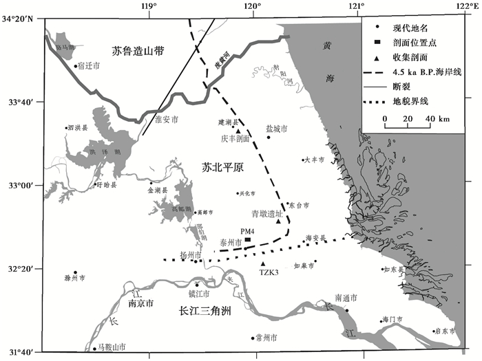
1 研究区域和剖面概况苏北平原(32°10′~35°05′N,118°40′~120°30′E)地处江苏省中部,东临黄海,西接盱眙、六合等低山丘陵(图 1),在内营力(构造沉降)、外营力(长江、海洋)的作用下[22],形成了地势平坦、原始坡降约万分之一左右的平原,其上河网密布,地面高程仅为0~10 m。苏北平原的西部又称里下河浅洼湖沼平原,全新世以来,经历了湖相(11.90~4.85 cal.ka B. P.)-滨海沼泽(4.85~4.25 cal.ka B. P.)-海湾(4.25~4.05 cal.ka B. P.)-潟湖(4.05~1.85 cal.ka B. P.)-湖相(1.85~0 cal.ka B. P.)的沉积环境演化过程[23]。
泰州PM4剖面(32°34′N,119°56′E)位于泰州市北侧9 km的北大洲农场(图 1),厚3.4 m,为一处自然露头。根据沉积物的物质成分、颗粒大小、沉积构造等特征对剖面自下而上分为7层:1)深灰-灰黑色含粉砂粘土(340~250 cm);2)灰黑色含粉砂粘土(250~160 cm);3)浅灰色含粉砂粘土(160~145 cm);4)灰色粉砂质粘土(145~110 cm);5)灰黄色粉砂(110~70 cm);6)灰色含粉砂粘土(70~60 cm);7)褐色粉砂质粘土(60~0 cm)。
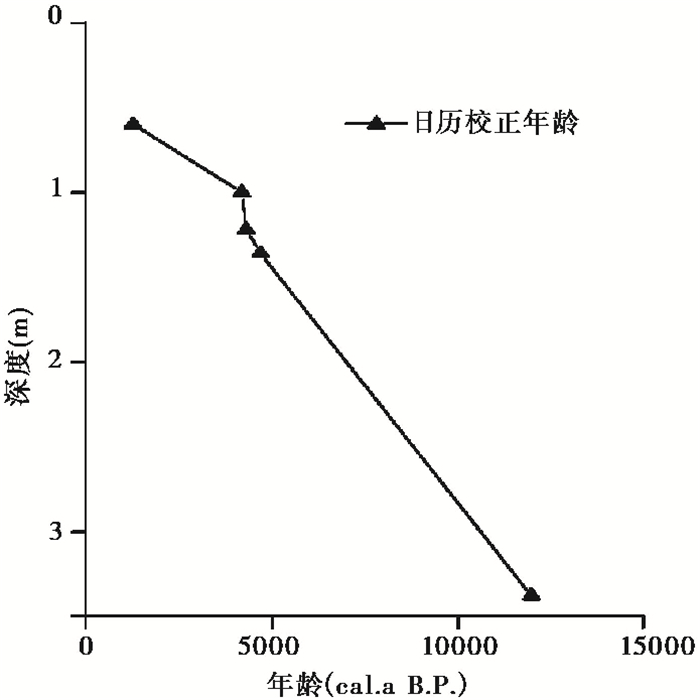
2 年龄框架和研究方法共选取7个样品送往波兰波兹南密茨凯维奇大学放射性碳实验室进行AMS14C测年,测年材料主要为有机质,有2个样品植物残体较少,使用全碳进行测年,结果见表 1。其中PM4-2和PM4-4的年龄出现了倒转,推测可能是因为PM4-4中砂质成分增加,水动力增强,物源变广;PM4-2中粉砂含量增加,砂质含量减少,物源发生了变化,部分老碳进入了测年样品,故测试的数据偏老。在年代框架中,我们去除了这2个倒转的年代数据,依据剩下的5个测试年龄进行线性内插,从而获得该剖面的时间标尺(图 2)[23],结果表明,该剖面的底界年龄为11.9 cal.ka B. P.;而距离剖面东南部约23 km,位于泰州南侧的TZK3孔12.1 cal.ka B. P.以来沉积地层厚43.92 m,沉积物以砂砾层为主,物质来源于长江[24],表明苏北平原和长江三角洲的界线位于TZK3孔和PM4剖面之间(图 1)。两孔全新世沉积物厚度的巨大差异主要是与长江的下蚀作用和物源不同有关。
孢粉分析与鉴定在中国科学院地理科学与资源研究所古环境分析实验室完成。按4 cm的间距采集孢粉样品82个,富含有机质呈青灰色、灰黑色的粘土、粉砂质粘土样品称取15~20 g,黄色、棕黄色、棕褐色粉砂和粘土质粉砂样品称取20~30 g,每个样品加1片石松孢子片(27637粒/片),依次经盐酸(10 %浓度)、氢氟酸(40 %浓度)、盐酸(10 %浓度)、KOH溶液(10 %浓度)处理,提取物分别经过100 μm、10 μm的滤布过滤。孢粉样品鉴定使用Olympus BX51显微镜,样品的鉴定均参考正式出版的现代孢粉图版[25],每个样品的孢粉统计量在300粒以上。孢粉鉴定和统计结果显示,孢粉浓度自下而上总体降低且变化较大,范围在1240~9944粒/g之间。
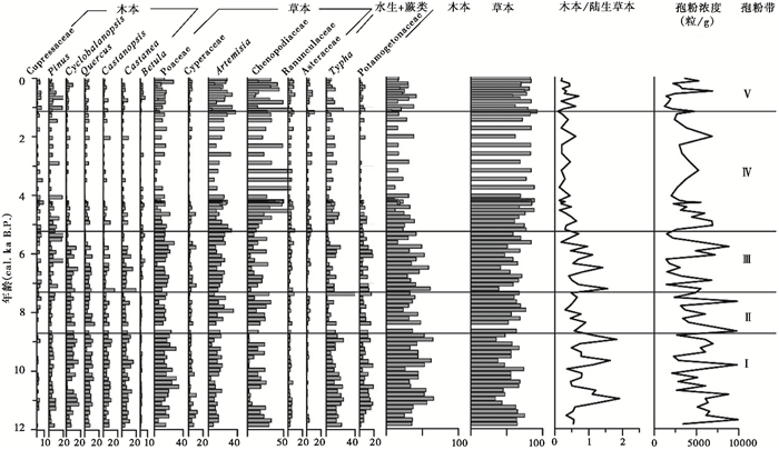
3 孢粉结果本次鉴定了82件样品,共30171粒孢粉,鉴定出孢粉类型(包括藻类和蕨类)45个,其中木本花粉主要包括针叶树的松属(Pinus)和柏科(Cupressaceae),零星见云杉属(Picea)、冷杉属(Abies);阔叶树花粉以壳斗科的青冈属(Cyclobalanopsis)、栎属(Quercus)、栗属(Castanea)、栲属(Castanopsis)为主,见少量的桦木属(Betula)、胡桃属(Juglans)、蔷薇科(Rosaceae)。草本植物花粉以禾本科(Poaceae)、莎草科(Cyperaceae)、蒿属(Artemisia)、藜科(Chenopodiaceae)为主,含有少量的毛茛科(Ranunculaceae)、菊科(Asteraceae)、伞形科(Apiaceae)、蓼科(Polygonaceae)、葎草属(Humulus)、十字花科(Brassicaceae)等;水生植物花粉包括香蒲属(Typha)和眼子菜科(Potamogetonaceae)等;藻类主要有环纹藻等;蕨类有水龙骨科(Polypodiaceae)、里白科(Gleicheniaceae)和三缝孢(Triletes)。依据剖面主要孢粉类型的百分比图谱(图 3),由下至上划出分5个孢粉组合带:

|
图 3 PM4剖面主要孢粉百分比图谱 Fig. 3 Pollen percentage diagram of PM4 section |
带Ⅰ (3.40~2.50 m;11.90~8.80 cal.ka B. P.),草本植物花粉含量相对较低(平均55.8 %),主要花粉类型为藜科(14.9 %)、蒿属(11.9 %)、莎草科(4.4 %)和毛茛科(3.1 %);木本植物花粉含量为全剖面最高值(25.0 %~65.7 %),主要包括阔叶树青冈属、栗属、栎属、栲属和针叶树松属;水生植物花粉主要为香蒲属(15.4 %);蕨类孢子主要为水龙骨科(10.1 %)。总体来说,带Ⅰ阔叶树花粉含量(44.2 %)、木本/陆生草本花粉含量比值(0.9)、孢粉平均浓度(5416粒/g)较高。
带Ⅱ (2.50~2.10 m;8.80~7.40 cal.ka B. P.),草本植物花粉百分含量增加,在52.3 %~76.6 %之间波动,平均为64.2 %,主要为藜科(21.4 %)和蒿属(17.7 %)花粉含量明显增加;而禾本科(14.8 %)和莎草科(3.1 %)花粉含量减少;木本植物花粉含量有所降低(23.4 %~47.7 %,平均35.8 %),其中阔叶树种青冈属(8.2 %)、栎属(7.4 %)、栗属(6.0 %)和栲属(5.5 %)花粉含量减少;此外,水生植物香蒲属(10.5 %)花粉明显减少。木本/陆生草本花粉含量比值(0.6)和孢粉浓度(5237粒/g)降低。
带Ⅲ (2.10~1.50 m;7.40~5.20 cal.ka B. P.),草本植物花粉百分含量减少(39.1 %~84.2 %,平均为60.8 %)。主要表现为藜科(14.3 %)和菊科(2.5 %)花粉含量明显减少。而蒿属、禾本科、毛茛科、莎草科花粉含量有所增加;木本植物花粉含量有所增加(30.2 %~60.9 %,平均39.2 %),其中针叶树种松属(8.3 %)和柏科(3.3 %)花粉增加显著,阔叶树种青冈属(6.8 %)、栎属(5.2 %)和栲属(4.3 %)花粉含量减少;而桦属(2.3 %)和栗属(6.8 %)花粉有所增加。木本/陆生草本花粉含量比值(0.72)增加,而孢粉浓度(3823粒/g)减少。
带Ⅳ (1.50~0.50 m;5.20~1.08 cal.ka B. P.),草本植物花粉百分含量显著增加(78.5 %)。主要为藜科(38.1 %)、毛茛科(4.1 %)和菊科(3.2 %)花粉含量明显增加,而禾本科(10.8 %)和莎草科(1.9 %)花粉含量有所减少;木本植物的花粉含量迅速下降(21.5 %),主要为阔叶树种栎属(3.2 %)、栗属(2.9 %)、栲属(2.5 %)、青冈属(2.0 %)花粉含量减少。木本/陆生草本花粉含量比值(0.29)降低;孢粉浓度(3970粒/g)稍微增加。
带Ⅴ (0.50~0 m;1.08~0 cal.ka B. P.),草本植物花粉百分含量稍有降低(74.1 %),主要表现为藜科(27.0 %)花粉含量明显降低,而蒿属(22.2 %)、禾本科(12.9 %)和莎草科(2.6 %)花粉含量增加;木本植物花粉的含量有所增加(25.9 %),青冈属(3.2 %)、栗属(3.1 %)、桦属(2.4 %)、松属(8.2 %)花粉含量增加,而栲属(2.1 %)花粉含量有所减少。此外,蕨类孢子主要为水龙骨科(3.1 %)显著减少。木本/陆生草本花粉含量比值(为0.37)增加,而孢粉浓度(3011粒/g)稍微减少。
4 讨论 4.1 全新世以来苏北平原的植被更替根据PM4剖面孢粉组合的变化,可将全新世苏北平原全新世植被更替分为以下5个阶段:
阶段Ⅰ,11.90~8.80 cal.ka B. P.:该阶段的孢粉浓度较高,植被类型是以壳斗科的青冈属、栗属、栎属、栲属为建群种的森林植被类型,林中混生有桦属、胡桃属、枫香属、山核桃属、枫杨属等;林下生长着禾本科、藜科、蒿属、莎草科、毛茛科和菊科等植物;局部地区生长着松属和柏科等较喜湿的针叶林。淡水湖泊或水塘边生长香蒲等水生植物及淡水藻类环纹藻等,林下分布以水龙骨科为主的蕨类植物。木本/陆生草本花粉及孢粉浓度较大,表明本阶段该地区温度和降水较高,气候生态环境较为优越,植被为亚热带常绿、落叶阔叶混交林。
阶段Ⅱ,8.80~7.40 cal.ka B. P.:相比阶段Ⅰ,草本植物增加而木本植物减少。喜温热的阔叶树如栗属、栲属、胡桃属、枫香属和山核桃属等明显减少,表明气候有所变冷。喜湿的禾本科和莎草科明显减少,相对喜干的藜科和菊科等草本植物繁盛,表明降水减少。此外,本阶段木本/陆生草本花粉含量比值及孢粉浓度减少,显示气候变得相对冷干,生态环境变差,为常绿、落叶阔叶混交林-草地。
阶段Ⅲ,7.40~5.20 cal.ka B. P.:喜温热的青冈属、栎属、栲属减少,而喜温的落叶阔叶树桦属和栗属增加,表明温度有所降低。喜湿的松属、柏科、禾本科和莎草科繁盛,相对喜盐的藜科和菊科等草本植物减少,表明该时期降水增加而温度降低,为常绿、落叶阔叶混交林。
阶段Ⅳ,5.20~1.08 cal.ka B. P.:该段最大的特征是藜科的快速增加,而阔叶树如青冈属、栗属、栲属、栎属减少。已有的研究表明,研究区于4.85 cal.ka B. P.开始受到海洋作用[23],海岸线在泰州一带,地带性植被为盐生草甸。
阶段Ⅴ,1.08~0 cal.ka B. P.:由于海岸线向东迁移,研究区的藜科减少,而由于人类活动的影响,本地区栗属、栎属、青冈属等阔叶树减少。
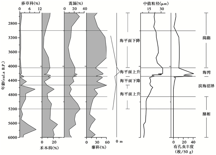
4.2 苏北平原植被对海平面变化的响应(5.20~3.00 ka B. P.)在自然条件下,江苏省海岸潮间带自上而下可分为草滩、泥滩、泥-粉砂滩和粉砂-细砂滩,中高潮位(草滩、泥滩)多为草本植物,向海方向草本植物逐渐减少,至低潮位无草本生长而出现沿岸流带来的花粉[26]。在潮上带中,由于海水咸度较高,一般植物难以生长,只有耐盐耐碱的植物才能繁殖,形成了滨海盐生植被类型,以藜科、禾本科、菊科为主[27]。萧家仪等[28]通过分析花粉数量与海岸线的关系,指出古沿海淤泥质沉积物中藜科花粉超过30 %,古环境可以判定为潮上带;如果藜科花粉含量为20 %~30 %,且禾本科和莎草科的花粉较多,为海滨盐沼植被景观,研究区离古海岸线不远。González和Dupont[29]通过委内瑞拉钻孔中的孢粉记录显示,藜科可用来指示高盐度的潮上带环境,藜科→禾本科→莎草科的植被演替可以反映海平面变化过程。因此,海岸带藜科植物(盐生植物或者耐盐植物的典型代表)及其花粉含量或者浓度,可以反映海岸线或者潮上带的长期变化。莎草科为淡水的水生草本,主要分布在潮湿或沼泽处[30]。本文以藜科、蒿属、禾本科和莎草科的含量变化为基础,结合中值粒径[23]、有孔虫丰度[23]及沉积环境的变迁,重建了海平面相对变化历史以及植被的响应过程(图 4)。

|
图 4 苏北平原5.2~3.0 ka B. P.中值粒径[23]、有孔虫丰度[23]、藜科-蒿属-禾本科-莎草科百分比含量所反映的海平面变化 Fig. 4 Sea-level changes reflected by median grain size[23], abundance of foraminifera[23], percentages of Chenopaceae, Artemisia, Poaceae and Cyperaceae during 5.2~3.0 ka B. P. in Subei plain |
虽然全球海平面和东海海平面在5 cal.ka B. P.以后趋于稳定[18, 31],但是在中国东部沿海地区,由于冰川-水均衡作用[32~34]、区域差异性构造沉降[35]等多因素的影响,其海平面存在明显的波动[36~38]。研究区在11.90~4.85 cal.ka B. P.为湖相沉积环境[23],藜科含量自5.20 cal.ka B. P.开始逐渐增加,表明研究区与海岸线的距离逐步缩短,5.20~4.85 cal.ka B. P.为海平面上升阶段,植被表现为喜盐的藜科和喜湿莎草科增加,而喜干蒿属减少;4.85~4.55 cal.ka B. P.为滨海沼泽环境[23],喜盐的藜科及喜湿莎草科持续繁盛,而喜干的蒿属减少,表明研究区与海岸线的距离进一步缩小,海平面处于持续上升阶段;4.55~4.25 cal.ka B. P.,沉积环境仍为滨海沼泽,但喜盐的藜科、喜湿莎草科减少,而喜干的蒿属增加,表明研究区与海岸线的距离增加,海岸线向东迁移,该时期海平面处于下降阶段;4.25~4.05 cal.ka B. P.,为海湾环境[23],藜科含量降低,淡水的莎草科快速减少,表明该阶段海平面上升,研究区被海水淹没;4.05~3.00 cal.ka B. P.,研究区为潟湖环境[23],海水逐渐退去,土壤盐度较高,耐盐耐碱的植被繁盛,以藜科为主,含有少量蒿属,而淡水植物禾本科和莎草科不易生长。随着海平面不断下降,海岸线向东迁移,土壤不断受到雨水和地表径流的淋洗,使得原来积累在表土中的盐分逐渐减低[27],蒿属和禾本科植物逐渐繁盛,而耐盐植物藜科减少(3.00~1.85 cal.ka B. P.)。
综上所述,5.20~3.00 cal.ka B. P.研究区的相对海平面存在多次升降变化:5.20~4.55 cal.ka B. P.相对海平面逐渐上升,4.55~4.25 cal.ka B. P.为下降阶段,4.25~4.05 cal.ka B. P.为高海平面阶段,4.05~3.00 cal.ka B. P.,海平面逐渐下降至现代海平面高度。该结果与庆丰剖面微体古生物反映的海平面变化[39]较为一致,其研究结果表明,5.1~4.6 ka B. P.,海平面下降至0 m左右,而后又迅速回升,4.4~4.0 ka B. P.海平面高度超过现今3 m左右[39]。
4.3 苏北平原4.25~4.05 cal.ka B. P.高海平面本研究PM4剖面的中值粒径、有孔虫、孢粉组合(图 4)记录显示,4.25~4.05 cal.ka B. P.期间有孔虫丰度呈显著升高,中值粒径急剧增加[23],藜科含量降低,淡水的莎草科快速减少,沉积环境从滨海沼泽转向海湾环境,这些指标记录反映出4.25~4.05 ka B. P.期间,研究区具有相对高的海平面。在PM4剖面西侧的海安青墩遗址剖面在4 ka(14C年龄)出现了厚1 m多的自然沉积层,该沉积层底部含有多种咸水种类(刺甲藻、多刺藻、圆膜藻、舌藻等),也指示该时期为高海平面阶段,之后海平面下降[40]。庆丰剖面的结果也显示,建湖地区在4.4~4.0 ka为高海平面时期[39]。
苏北平原这一高海平面的时段与大范围尺度的“4.2 ka气候事件”可以较好的对应。“4.2 ka气候事件”已经在全世界的海洋沉积物[41]、湖泊沉积物[42]、冰芯[43]、石笋[44~45]、泥炭[46~47]等古气候材料中得到证实[48],在“4.2 ka气候事件”期间,太阳辐射减弱导致赤道幅合带(ITCZ)南移[49~50],东亚季风减弱[51]。较弱的夏季风会导致长江流域或江南多雨,形成“北旱南涝”的气候格局[52~53],中国江汉盆地[54~55]、淮河流域[8]、上海地区[56]、太湖平原[57~58]已发现了大规模的洪水证据。苏北地区的强降雨、大规模洪水(大量的淡水资源)和长江携带的丰富物源可能会导致相对海平面上升,同时,海平面上升也会诱发大规模的洪水事件和沿海极端风暴洪水[59]。
“4.2 ka气候事件”是导致中国滨海平原新石器文化兴盛衰亡的重要原因之一[60]。苏北平原青墩遗址地区4 ka(14C年龄)古文明的衰落是海侵事件所致[40];太湖平原的良渚文化在5.1~4.3 ka B. P.水位较低时快速发展[14],水位上升[14]或者洪水事件[57]导致良渚文化衰落(4.3~3.8 ka B. P.)[58];宁绍平原的禹山遗址显示4.4~5 ka B. P.高海平面及引起的风暴潮是导致该地区良渚文化衰亡的主要因素[16~17];长江三角洲地区新石器文明衰落是4.2 ka气候事件(4.4~3.8 cal.ka B. P.期间)极端的寒冷事件(SST比现在低3~4 ℃)所致[61]。
因此,4.25~4.05 cal.ka B. P.期间,苏北平原海平面上升是对“4.2 ka气候事件”的响应,但海平面上升的原因仍需进一步讨论。该气候事件的时间序列以及结构特征还需要更多高分辨率材料研究,且该气候事件对人类古文明的影响机制仍需深入探讨。
5 结论(1) 本研究中PM4剖面的化石孢粉记录揭示了全新世以来苏北平原的植被经历了5个主要演替阶段:1)11.90~8.80 cal.ka B. P.,地带性植被为以壳斗科为主的亚热带常绿、落叶阔叶混交林,气候温暖湿润,环境适宜;2)8.80~7.40 cal.ka B. P.,木本植物减少,草本植物增加,植被为常绿、落叶阔叶混交林-草地,气候变冷变干;3)7.40~5.20 cal.ka B. P.,藜科等草本植物减少,木本植物增加,地带性植被为常绿、落叶阔叶混交林,指示出温度降低而湿度有所增加;4)5.20~1.08 cal.ka B. P.,草本植物中藜科迅速增加,木本植物减少,植被退化为盐生草甸;5)1.08~0 cal.ka B. P.,藜科植物减少,植被中湿生草本群落繁盛。
(2) 通过藜科、蒿属、禾本科和莎草科的含量变化及其记录的植被响应可重建苏北平原5.20~3.00 ka B. P.的海平面波动:1)5.20~4.55 cal.ka B. P.,耐盐藜科和喜湿莎草科增加,而耐干的蒿属减少,指示了海平面上升;2)4.55~4.25 cal.ka B. P.,藜科、莎草科减少,蒿属增加,沉积环境为滨海沼泽环境,对应了海平面下降阶段;3)4.25~4.05 cal.ka B. P.,藜科含量降低,莎草科含量快速减少,表明该阶段海平面上升,研究区被海水淹没;4)4.05~3.00 cal.ka B. P.,以藜科植物为主,含有少量蒿属植物,禾本科和莎草科的含量较低,海平面下降。
(3) 苏北平原4.25~4.05 ka B. P.的海平面上升过程是对“4.2 ka气候事件”的响应。当时东亚季风减弱、中国东部地区的强降水及大规模的洪水事件可能是海平面上升的主要原因。
致谢: 感谢蔡茂堂博士对孢粉样品的分析与鉴定,感谢舒军武副研究员对本文的指导,感谢同行评审专家和编辑赵淑君老师提出的宝贵建议!
| [1] |
Cohen K M, Finney S C, Gibbard P L, et al. The ICS international chronostratigraphic chart[J]. Episodes, 2013, 36(3): 199-204. |
| [2] |
Weiss H, Bradley R S. What drives societal collapse?[J]. Science, 2001, 291(5504): 609-610. DOI:10.1126/science.1058775 |
| [3] |
Hodell D A, Curtis J, Brenner M. Possible role of climate in the collapse of classic Maya civilization[J]. Nature, 1995, 375(6530): 391-394. DOI:10.1038/375391a0 |
| [4] |
Weiss H, Courty M A, Wetterstrom W, et al. The genesis and collapse of third millennium north Mesopotamian civilization[J]. Science, 1993, 261(5124): 995-1004. DOI:10.1126/science.261.5124.995 |
| [5] |
Demenocal P B. Cultural responses to climate change during the Late Holocene[J]. Science, 2001, 292(5517): 667-673. DOI:10.1126/science.1059827 |
| [6] |
An C B, Tang L, Loukas B, et al. Climate change and cultural response around 4000 cal yr B. P. in the western part of Chinese Loess Plateau[J]. Quaternary Research, 2005, 63(3): 347-352. DOI:10.1016/j.yqres.2005.02.004 |
| [7] |
刘峰贵, 侯光良, 张镱锂, 等. 中全新世气候突变对青海东北部史前文化的影响[J]. 地理学报, 2005, 60(5): 733-741. Liu Fenggui, Hou Guangliang, Zhang Yili, et al. The impact of abrupt climate change in mid-Holocene on the prehistoric culture in northeast Qinghai[J]. Acta Geographica Sinica, 2005, 60(5): 733-741. DOI:10.3321/j.issn:0375-5444.2005.05.004 |
| [8] |
张广胜, 朱诚, 王吉怀, 等. 安徽蚌埠禹会村遗址4.5-4.0 ka BP龙山文化的环境考古[J]. 地理学报, 2009, 64(7): 817-827. Zhang Guangsheng, Zhu Cheng, Wang Jihuai, et al. Environmental archaeology of Longshan Culture period on Yuhuicun site from 4.5 ka to 4.0 ka BP, Bengbu, Anhui[J]. Acta Geographica sinica, 2009, 64(7): 817-827. DOI:10.3321/j.issn:0375-5444.2009.07.006 |
| [9] |
方修琦, 孙宁. 降温事件:4.3 ka BP岱海老虎山文化中断的可能原因[J]. 人文地理, 1998, 13(1): 75-80. Fang Xiuqi, Sun Ning. Cold event:A possible cause of the interruption of the Laohushan culture[J]. Human Geography, 1998, 13(1): 75-80. |
| [10] |
Xiao J, Zhang S, Fan J, et al. The 4.2 ka event and its resulting cultural interruption in the Daihai Lake basin at the East Asian summer monsoon margin[J]. Quaternary International, 2018. DOI:10.1016/j.quaint.2018.06.025 |
| [11] |
Yasuda Y, Fujiki T, Nasu H, et al. Environmental archaeology at the Chengtoushan site, Hunan Province, China, and implications for environmental change and the rise and fall of the Yangtze River civilization[J]. Quaternary International, 2004, 123. DOI:10.1016/j.quaint.2004.02.016 |
| [12] |
徐军. 连云港新石器时代人类聚居遗址分布与海岸线变迁关系的剖析[J]. 第四纪研究, 2006, 26(3): 353-360. Xu Jun. The distribution of Neolithic archaeological ruins around Lianyungang area and their relation to coast line changes[J]. Quaternary Sciences, 2006, 26(3): 353-360. DOI:10.3321/j.issn:1001-7410.2006.03.006 |
| [13] |
朱丽东, 冯义雄, 叶玮, 等. 良渚时期文化发展与海平面变化[J]. 地理科学进展, 2011, 30(1): 121-128. Zhu Lidong, Feng Yixiong, Ye Wei, et al. Culture development and sea-level change during Liangzhu Period[J]. Progress in Geography, 2011, 30(1): 121-128. |
| [14] |
史辰羲, 莫多闻, 李春海, 等. 浙江良渚遗址群环境演变与人类活动的关系[J]. 地学前缘, 2011, 18(3): 347-356. Shi Chenxi, Mo Duowen, Li Chunhai, et al. The relationship between environmental evolution and human activities in Liangzhu sites group, Zhejiang Province[J]. Earth Science Frontiers, 2011, 18(3): 347-356. |
| [15] |
郑洪波, 周友胜, 杨青, 等. 中国东部滨海平原新石器遗址的时空分布格局——海平面变化控制下的地貌演化与人地关系[J]. 中国科学:地球科学, 2018, 61(2): 127-137. Zheng Hongbo, Zhou Yousheng, Yang Qing, et al. Spatial and temporal distribution of Neolithic sites in coastal China:Sea level changes, geomorphic evolution and human adaption[J]. Science China:Earth Sciences, 2018, 61(2): 123-133. |
| [16] |
He K Y, Lu H Y, Zheng Y F, et al. Middle-Holocene sea-level fluctuations interrupted the developing Hemudu Culture in the lower Yangtze River, China[J]. Quaternary Science Reviews, 2018, 188: 90-103. DOI:10.1016/j.quascirev.2018.03.034 |
| [17] |
Wang Z H, Ryves D B, Lei S, et al. Middle Holocene marine flooding and human response in the south Yangtze coastal plain, East China[J]. Quaternary Science Reviews, 2018, 187: 80-93. DOI:10.1016/j.quascirev.2018.03.001 |
| [18] |
Lambeck K, Rouby H, Purcell A, et al. Sea level and global ice volumes from the Last Glacial Maximum to the Holocene[J]. Proceedings of the National Academy of Sciences of the United States of America, 2014, 111(43): 15296-15303. DOI:10.1073/pnas.1411762111 |
| [19] |
赵希涛, 耿秀山, 张景文. 中国东部20000年来的海平面变化[J]. 海洋学报, 1979, 1(2): 269-281. Zhao Xitao, Geng Xiushan, Zhang Jingwen. Sea level changes of the Eastern China during the past 20000 years[J]. Acta Oceanologia Sinica, 1979, 1(2): 269-281. |
| [20] |
杨怀仁, 谢志仁. 中国东部近20, 000年来的气候波动与海面升降运动[J]. 海洋与湖沼, 1984, 15(1): 1-13. Yang Huairen, Xie Zhiren. Sea-level changes along the east coast of China over the last 2000 years[J]. Oceanologia et Limnologia Sinica, 1984, 15(1): 1-13. |
| [21] |
赵希涛, 唐领余, 沈才明, 等. 江苏建湖庆丰剖面全新世气候变迁和海面变化[J]. 海洋学报, 1994, 16(1): 78-88. Zhao Xitao, Tang Lingyu, Shen Caiming, et al. Climate evolution and sea level change based on Qingfeng section, Jianhu, Jiangsu[J]. Acta Oceanologia Sinica, 1994, 16(1): 78-88. DOI:10.3321/j.issn:0253-4193.1994.01.004 |
| [22] |
Cheng Y, Li X Q, Shu J W, et al. Sedimentary evolution and transgressions of the western Subei Basin in Eastern China since the Late Pliocene[J]. Acta Geologica Sinica(English edition), 2019, 93(1): 155-166. DOI:10.1111/acgs.2019.93.issue-1 |
| [23] |
程瑜, 李向前, 赵增玉, 等. 全新世以来苏北平原里下河南部地区的沉积记录和环境演化[J]. 海洋地质与第四纪地质, 2019, 39(1): 46-55. Cheng Yu, Li Xiangqian, Zhao Zengyu, et al. Sedimentary records and environmental evolution of the southern Lixiahe in Subei plain during the Holocene[J]. Marine Geology & Quanternary Geology, 2019, 39(1): 46-55. |
| [24] |
程瑜, 李向前, 舒军武, 等. 末次冰期以来长江三角洲的沉积特征和环境演化[J]. 第四纪研究, 2018, 38(3): 746-755. Cheng Yu, Li Xiangqian, Shu Junwu, et al. The formation and evolution of the Changjiang River delta since last glacial[J]. Quaternary Sciences, 2018, 38(3): 746-755. |
| [25] |
王伏雄, 钱南芬, 张玉龙, 等. 中国植物孢粉形态(第二版)[M]. 北京: 科学出版社, 1995: 1-461. Wang Fuxiong, Qian Nanfen, Zhang Yulong, et al. Pollen Flora of China(second edition)[M]. Beijing: Science Press, 1995: 1-461. |
| [26] |
王颖, 朱大奎. 中国的潮滩[J]. 第四纪研究, 1990(4): 291-300. Wang Ying, Zhu Dakui. Tidal flats of China[J]. Quaternary Sciences, 1990(4): 291-300. DOI:10.3321/j.issn:1001-7410.1990.04.001 |
| [27] |
单树模, 王维屏, 王庭槐. 江苏省地理[M]. 南京: 江苏人民出版社, 1980: 1-193. Shan Shumo, Wang Weiping, Wang Tinghuai. Geography in Jiangsu Province[M]. Nanjing: Jiangsu Peoples Publishing, 1980: 1-193. |
| [28] |
萧家仪, 吕燕, 祁国翔. 中国东部淤泥质海岸盐沼植被藜科花粉数量研究[J]. 地理研究, 2014, 33(11): 2157-2168. Xiao Jiayi, Lü Yan, Qi Guoxiang. On the quantity of Chenopodiaceae pollen in salt marsh vegetation of muddy coast in East China[J]. Geographical Research, 2014, 33(11): 2157-2168. |
| [29] |
González C, Dupont L M. Tropical salt marsh succession as sea-level indicator during Heinrich events[J]. Quaternary Science Reviews, 2009, 28(9): 939-946. |
| [30] |
庞莉莉, 李玉双, 陈洁, 等. 江苏省莎草科植物资源分布特点与应用分析[J]. 植物分类与资源学报, 2015, 37(5): 616-628. Pang Lili, Li Yushuang, Chen Jie, et al. The distribution characteristics and application of Cyperaceae plant resources in Jiangsu Province[J]. Plant Diversity and Resources, 2015, 37(5): 616-628. |
| [31] |
Li G X, Li P, Liu Y, et al. Sedimentary system response to the global sea level change in the East China seas since the Last Glacial Maximum[J]. Earth-Science Reviews, 2014, 139: 390-405. DOI:10.1016/j.earscirev.2014.09.007 |
| [32] |
Wang Z H, Zhuang C C, Saito Y, et al. Early mid-Holocene sea-level change and coastal environmental response on the southern Yangtze Delta plain, China:Implications for the rise of Neolithic culture[J]. Quaternary Science Reviews, 2012, 35(6): 51-62. |
| [33] |
Hori K, Saito Y, Zhao Q, et al. Sedimentary facies and Holocene progradation rates of the Changjiang(Yangtze)delta, China[J]. Geomorphology, 2001, 41(2): 233-248. |
| [34] |
于革, 叶良涛, 廖梦娜, 等. 我国沿海平原晚更新世海侵的定量重建、模拟与机制研究[J]. 第四纪研究, 2016, 36(3): 711-721. Yu Ge, Ye Liangtao, Liao Mengna, et al. Quantitative reconstruction, simulation and mechanism study on the Late Pleistocene marine transgressions[J]. Quaternary Sciences, 2016, 36(3): 711-721. |
| [35] |
辛立国, 李广雪, 李西双, 等. 中国东海2万年来海平面变化分析[J]. 中国海洋大学学报, 2006, 36(5): 699-704. Xin Liguo, Li Guangxue, Li Xishuang, et al. Analysis of sea-level variation the East China Sea since the Last Glacial Maximum[J]. Periodical of Ocean University of China, 2006, 36(5): 699-704. |
| [36] |
廖梦娜, 于革, 桂峰. 长江三角洲-辐射沙脊群YZ07钻孔晚更新世以来海侵事件的古生态学记录[J]. 第四纪研究, 2018, 38(3): 732-745. Liao Mengna, Yu Ge, Gui Feng. Paleoecological records of transgressions in Core YZ07 from Changjiang River delta-radial sand ridges of the South Yellow Sea since the Late Pleistocene[J]. Quaternary Sciences, 2018, 38(3): 732-745. |
| [37] |
梁钰莹, 李冬玲, 沙龙滨, 等. 浙江湘湖早-中全新世的硅藻记录及沉积环境演变[J]. 第四纪研究, 2018, 38(4): 842-853. Liang Yuying, Li Dongling, Sha Longbin, et al. Early to mid-Holocene sedimentary environment evolution in Xianghu Lake area, Zhejiang Province, based on a diatom record[J]. Quaternary Sciences, 2018, 38(4): 842-853. |
| [38] |
马明明, 葛伟亚, 李春海, 等. 福建霞浦钻孔沉积物记录的约7800 a B. P.以来海平面波动的磁学响应[J]. 第四纪研究, 2016, 36(5): 1307-1318. Ma Mingming, Ge Weiya, Li Chunhai, et al. Magnetic responses to sea-level fluctuations since about 7800 a B. P. recorded by core sediments at Xiapu, Fujian[J]. Quaternary Sciences, 2016, 36(5): 1307-1318. |
| [39] |
王绍鸿, 赵希涛. 江苏建湖庆丰剖面全新世有孔虫与海面变化[J]. 福建师大学报(自然科学版), 1997, 13(1): 105-111. Wang Shaohong, Zhao Xitao. Holocene forminiferal fauna and sea level changes in Qingfeng section, Jianhu County, Jiangsu Province[J]. Journal of Fujian Normal University(Natural Science), 1997, 13(1): 105-111. |
| [40] |
朱诚, 张强, 张芸, 等. 长江三角洲长江以北地区全新世以来人地关系的环境考古研究[J]. 地理科学, 2003, 23(6): 705-712. Zhu Cheng, Zhang Qiang, Zhang Yun, et al. Relationship between human and nature in the north part of the Yangtze Delta since the Holocene[J]. Scientia Geographica Sinica, 2003, 23(6): 705-712. DOI:10.3969/j.issn.1000-0690.2003.06.011 |
| [41] |
Arz H W, Lamy F, Pätzold J. A pronounced dry event recorded around 4.2 ka in brine sediments from the northern Red Sea[J]. Quaternary Research, 2006, 66(3): 432-441. DOI:10.1016/j.yqres.2006.05.006 |
| [42] |
Nakamura A, Yokoyama Y, Maemoku H, et al. Weak monsoon event at 4.2 ka recorded in sediment from Lake Rara, Himalayas[J]. Quaternary International, 2016, 397: 349-359. DOI:10.1016/j.quaint.2015.05.053 |
| [43] |
Thompson L G, Beer J. Kilimanjaro ice core records:evidence of Holocene climate change in tropical Africa[J]. Science, 2002, 298(5593): 589-593. DOI:10.1126/science.1073198 |
| [44] |
Berkelhammer M, Sinha A, Stott L, et al. An abrupt shift in the Indian monsoon 4000 years ago[M]//Giosan Liviu, Fuller Q Dorian, Nicoll Kathleen eds. Climates, Landscapes, and Civilizations. Wiley: American Geophysical Union, Geophysical Monograph Series 198, 2012: 75-87. doi: 10.1029/2012GM001207.
|
| [45] |
Railsback L B, Liang F, Brook G A, et al. The timing, two-pulsed nature, and variable climatic expression of the 4.2 ka event:A review and new high-resolution stalagmite data from Namibia[J]. Quaternary Science Reviews, 2018, 86: 78-90. DOI:10.1016/j.quascirev.2018.02.015 |
| [46] |
张贵林, 周新郢, 赵克良, 等. 沙漠/黄土过渡带6 ka B. P.以来气候环境变化及其对人类活动的影响[J]. 第四纪研究, 2018, 38(4): 874-886. Zhang Guilin, Zhou Xinying, Zhao Keliang, et al. Climate and environment change of desert/loess transition zone and its impact on prehistoric human activities since 6 ka B. P.[J]. Quaternary Sciences, 2018, 38(4): 874-886. |
| [47] |
牛蕊, 周立旻, 孟庆浩, 等. 贵州草海南屯泥炭记录的中全新世以来的气候变化[J]. 第四纪研究, 2017, 37(6): 1357-1369. Niu Rui, Zhou Limin, Meng Qinghao, et al. The paleoclimate variations of the Nantun peat in the Caohai area since the Middle Holocene[J]. Quaternary Sciences, 2017, 37(6): 1357-1369. |
| [48] |
Weiss H. Global megadrought, societal collapse and resilience at 4.2-3.9 ka BP across the Mediterranean and West Asia[J]. PAGES, 2016, 24(2): 62-63. DOI:10.22498/pages |
| [49] |
Bond G, Kromer B, Beer J, et al. Persistent solar influence on North Atlantic climate during the Holocene[J]. Science, 2001, 294(5549): 2130-2136. DOI:10.1126/science.1065680 |
| [50] |
Baker P A, Seltzer G O, Fritz S C, et al. The history of South American tropical precipitation for the past 25, 000 years[J]. Science, 2001, 291(5504): 640-643. DOI:10.1126/science.291.5504.640 |
| [51] |
Wang Y, Cheng H, Edwards R L, et al. The Holocene Asian monsoon:Links to solar changes and North Atlantic climate[J]. Science, 2005, 308(5723): 854-857. DOI:10.1126/science.1106296 |
| [52] |
Wu W, Liu T. Possible role of the "Holocene Event 3" on the collapse of Neolithic cultures around the Central Plain of China[J]. Quaternary International, 2004, 117(1): 153-166. DOI:10.1016/S1040-6182(03)00125-3 |
| [53] |
吴文祥, 刘东生. 4000 a B. P.前后东亚季风变迁与中原周围地区新石器文化的衰落[J]. 第四纪研究, 2004, 24(3): 278-284. Wu Wenxiang, Liu Tungsheng. Variations in east Asia monsoon around 4000 a B. P. and the collapse of Neolithic culture around Central Plain[J]. Quaternary Sciences, 2004, 24(3): 278-284. DOI:10.3321/j.issn:1001-7410.2004.03.006 |
| [54] |
朱诚, 于世永, 卢春成. 长江三峡及江汉平原地区全新世环境考古与异常洪涝灾害研究[J]. 地理学报, 1997, 52(3): 268-278. Zhu Cheng, Yu Shiyong, Lu Chuncheng. Archaeology and extreme flood disaster in the Three Gorges of the Changjiang River and the Jianghan plain[J]. Acta Geographica Sinica, 1997, 52(3): 268-278. DOI:10.3321/j.issn:0375-5444.1997.03.010 |
| [55] |
吴立, 朱诚, 李枫, 等. 江汉平原钟桥遗址地层揭示的史前洪水事件[J]. 地理学报, 2015, 70(7): 1149-1164. Wu Li, Zhu Cheng, Li Feng, et al. Prehistoric flood events recorded at the Zhongqiao Neolithic site in Jianghan plain, Central China[J]. Acta Geographica Sinica, 2015, 70(7): 1149-1164. |
| [56] |
张强, 刘春玲, 朱诚, 等. 长江三角洲地区全新世以来环境变迁对人类活动的影响[J]. 海洋地质与第四纪地质, 2004, 24(4): 9-15. Zhang Qiang, Liu Chunling, Zhu Cheng, et al. Impact of environmental changes on human activities during the Holocene in the Changjiang(Yangtze)River delta region[J]. Marine Geology & Quaternary Geology, 2004, 24(4): 9-15. |
| [57] |
申洪源, 朱诚, 贾玉连. 太湖流域地貌与环境变迁对新石器文化传承的影响[J]. 地理科学, 2004, 24(5): 580-585. Shen Hongyuan, Zhu Cheng, Jia Yulian. Impact of geomorphology and environmental variance on Neolithic culture evolution in Taihu basin[J]. Scientia Geographica Sinica, 2004, 24(5): 580-585. DOI:10.3969/j.issn.1000-0690.2004.05.011 |
| [58] |
史威, 马春梅, 朱诚, 等. 太湖地区多剖面地层学分析与良渚期环境事件[J]. 地理研究, 2008, 27(5): 1129-1138. Shi Wei, Ma Chunmei, Zhu Cheng, et al. Analysis of stratigraphy on multi-profiles in the Taihu Lake region and paleoenvironmental events in the Liangzhu culture epoch[J]. Geographical Research, 2008, 27(5): 1129-1138. DOI:10.3321/j.issn:1000-0585.2008.05.016 |
| [59] |
殷杰, 尹占娥, 于大鹏, 等. 海平面上升背景下黄浦江极端风暴洪水危险性分析[J]. 地理研究, 2013, 32(12): 2215-2221. Yin Jie, Yin Zhan'e, Yu Dapeng, et al. Hazard analysis of extreme storm flooding in context of sea level rise:A case study of Huangpu River Basin[J]. Geographical Research, 2013, 32(12): 2215-2221. |
| [60] |
马春梅, 王冰翎, 刘泽雨, 等. 浙江田螺山遗址区孢粉学记录的中全新世植被、环境和人类活动初步研究[J]. 第四纪研究, 2018, 38(5): 1304-1312. Ma Chunmei, Wang Bingling, Liu Zeyu, et al. A preliminary study on vegetation, environment and human activity of pollen records during Middle-Late Holocene in Tianluoshan site, Ningshao Plain[J]. Quaternary Sciences, 2018, 38(5): 1304-1312. |
| [61] |
Kajita H, Kawahata H, Wang K, et al. Extraordinary cold episodes during the mid-Holocene in the Yangtze Delta:Interruption of the earliest rice cultivating civilization[J]. Quaternary Science Reviews, 2018, 201: 418-428. DOI:10.1016/j.quascirev.2018.10.035 |
2 Institute of Geomechanics, Chinese Academy of Geological Sciences, Beijing 100081)
Abstract
The studied section PM4 is located in the north of Taizhou City(32°34'N, 119°56'E), southwestern Subei plain, the basal age of the section is 11.9 cal.ka B.P. The lithology of the section are composed of silt, silty clay and clay, and abundant organic residues were also found in the sediment. In total, 82 samples were collected for palynological analysis at an interval of 4 cm in the 3.4 m-thick section.Based on the results of palynological analysis, we reconstructed 5 stages of vegetation change:(1) 11.90~8.80 cal.ka B. P., subtropical evergreen and deciduous broadleaved forests developed as the zonal vegetation in the study area. They were dominated by Fagaceae trees(e.g. Cyclobalanopsis, Castanea, Quercus, Castanopsis). The climate was warm and humid. (2) 8.80~7.40 cal.ka B. P., herb taxa showed an expansion into the evergreen and deciduous broadleaved forests, as indicated by the increase of Chenopodaceae and Artemisia. The inferred climate condition turned to be relatively cold and dry. (3) 7.40~5.20 cal.ka B. P., the pollen contents of Betula, Castanea, Pinus, Curpressaceae, Poaceae and Cyperaceae increased, while the Cyclobalanopsis, Quercus and Castanopsis, Chenopodiaceae and Asteraceae decreased. It is suggested that the precipitation would increase and the temperature decrease during this period. (4) 5.20~1.08 cal ka B. P., herb taxa expanded with a dramatic increase of Chenopodiaceae. The vegetation is salt marsh in the study area. (5) 1.08~0 cal.ka B. P, the contents of Chenopodiaceae and arboreal pollen decreased, due to the eastward movement of the coastline and possible human activity.The content variations of Chenopodiaceae, Artemisia, Poaceae and Cyperaceae can reflect the sea-level fluctuations by their implications for the vegetation response under the changing sea level. (1) During 5.20~4.55 cal.ka B. P, the contents of Chenopodiaceae(as a typical taxon in coastal saline vegetation) and Cyperaceae pollen increased, while those of Artemisia decreased, indicating that the sea level rose up. (2) During 4.55~4.25 cal.ka B. P., Artemisia increased, while Chenopodiaceae and Cyperaceae sharply decreased, suggesting a relative fall of sea level. (3) From 4.25 cal.ka B.P. to 4.05 cal.ka B. P., Chenopodiaceae and Cyperaceae sharply decreased, indicating that the sea level rose up again and more area was submerged. (4) During 4.05~3.00 cal.ka B. P., local vegetation was mainly composed of Chenopodiaceae plants with a small amount of Artemisia, Poaceae and Cyperaceae, indicating that the sea level decreased. (5) During 3.00~1.85 cal.ka B. P., Chenopodiaceae reduced along with the decrease of soil salinity, while Artemisia and Poaceae plants gradually increased, reflecting the further withdraw of sea level.The sea-level rising in the Subei plain during 4.25~4.05 cal.ka B. P. can be coincided with the worldwide "4.2 ka B. P." climatic event. The weakening of the East Asian monsoon, related strengthening of precipitation and large-scaled flood events in Eastern China could be responsible for the rise of the sea level in the Subei plain. 2019, Vol.39


