2 中国科学院、水利部成都山地灾害与环境研究所, 中国科学院山地灾害与地表过程重点实验室, 四川 成都 610041;
3 汕头大学海洋科学学院, 广东 汕头 515063;
4 中国科学院青藏高原研究所, 北京 100101;
5 青海师范大学, 青海省自然地理与环境过程重点实验室, 青海 西宁 810008)
造山带地形演化是构造、气候和地表侵蚀共同作用的结果,是地球各圈层相互作用的体现[1~5]。以河流侵蚀为主导的地表侵蚀作用不仅响应于构造活动和气候变化,而且往往还能影响到地球的深部活动[1, 4, 6]。河流被认为是能够记录造山带的构造活动、气候变化和水系演化等信息的地貌单位[7~11]。以基岩侵蚀模型为基础,利用河流纵剖面定量形态参数(比如,陡峭指数(ks)、凹度指数、河流裂点和Chi-plot等),能够揭示区域构造地貌演化的特点,已经得到了广泛的应用[12~23]。
河道基岩岩性、河道沉积物的补给强度、构造格局与强度、局地气候等各种内在因素的综合作用控制河流纵剖面的发育[24]。因此,其对研究流域自然地理特征和分析河谷发育过程、探讨区域新构造运动等都有着重要意义。近年来越来越多的研究发现河流纵剖面对堰塞作用具有显著的响应[25~27],而以往研究对河流纵剖面定量形态参数的解读并未考虑这点,会影响到利用河流形态揭示区域构造和气候变化的可靠性,甚至区域地貌形成机制的解释。特别是Korup和Montgomery[28]认为堰塞作用在冰期-间冰期的时间尺度反复出现,在河道上形成裂点,阻止了河流的溯源侵蚀,对保持青藏高原面的完整性起到了重要作用,将堰塞作用的地貌响应推到了地貌演化研究的前沿。已有的河流堰塞相关研究多集中在青藏高原周边高山峡谷区,例如藏东南、喀喇昆仑山等地区,分析其对河流泥沙淤积和侵蚀作用的持续影响[25, 29~30]、堰塞坝的稳定性及其地貌环境效应[31~36],同时也对部分古堰塞湖进行了绝对定年和重建[37~45]。总体而言,河流堰塞、洪水等极端事件作为重要的沉积物-基岩侵蚀搬运堆积过程,国内对于其对河流地貌演化的影响还缺乏充足的认识。
本人尝试对当前河流堰塞地貌响应的相关研究进行系统的总结,为深入认识基岩河道的演变以及造山带的地貌演化过程提供一个新的视角。在简要介绍河流堰塞地貌相关的基本概念的基础上,引出堰塞坝在河流纵剖面的作用,以及堰塞坝与河流裂点的耦合关系;并以青藏高原地区、新西兰南部和瑞士阿尔卑斯山、美国东俄勒冈以及土耳其西部等地区为具体实例,总结了河流对堰塞的响应过程及研究意义,提出并探讨了当前对单个堰塞坝体研究的不足和未来可能发展的新方向。
1 堰塞地貌的相关概念堰塞现象具有突发性、短暂性等显著特点,多发生在地质构造破碎、河谷纵比降变化大、构造运动活跃的地区和异常气候时期[32]。
1.1 堰塞的类型堰塞是指滑坡、冰川、冰碛和火山熔岩等阻塞河段形成堰塞湖,随后直至堰塞湖消亡的过程[46~47]。堰塞湖主要有以下3种类型[48~49],第一,阻塞峡谷(图 1a),其中即包括滑坡、泥石流、冰川和火山等自然过程,也包括人为修建的水电站,水库等;第二,注水的自然封闭盆地,如构造盆地,冰上盆地,冰碛盆地等(图 1b);第三,封闭于岩层或者冰下的地下水体(图 1c),如火星上的地下湖,南极的冰下湖等。第一类堰塞湖的研究案例最多,也是本文的主要讨论对象。盆地堰塞湖比较常见的形式是冰碛湖,即冰川末端消融后,在冰舌前端与终碛垄之间洼地积水成湖[46, 50]。冰碛湖分布广泛,据统计在第三极地区有5701个(> 0.003 km2)[51],但通常位于江河源头海拔较高的地区,湖体较小,对河流整体地貌的影响很小,因此本文不做讨论。

|
图 1 堰塞湖的类型示意图 Fig. 1 Schematic diagrams of different dammed lakes types |
河流纵剖面是反演区域构造和气候变化的重要工具,能够记录活动造山带地区基岩的隆升以及河流的下切过程[52~53]。当地形发育达到均衡的条件下,也就是基岩的隆升速率与河流的下切速率达到平衡,基岩河道的河床高程将不随时间改变,此时的河道纵剖面被称为均衡河道剖面[54~55]。河流纵剖面在均衡条件下,坡度会向下游随着流域面积的不断增大而逐渐减小,因此,整体表现为相对比较平滑,并呈现为下凹的形态[7]。一旦这一均衡状态被打破,则会在平滑下凹的河流纵剖面上形成上凸的纵剖面异常部位,即裂点[13]。在基岩水力侵蚀模型中,均衡条件下,河道参数关系可总结为公式如下:

|
(1) |
对河道比降(S)和流域面积(A)进行反演计算就可得到河道的陡峭指数(ks)和下凹度(θ),固定θ=0.45,对陡峭指数归一化(ksn)处理后,用于提取河流裂点,可代表河流纵剖面的变化,可用来指示堰塞的地貌响应。
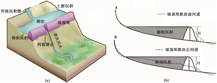
1.3 堰塞对河流系统的影响堰塞对河流系统的影响(图 2)[56],主要体现在以下两个方面:1)局地侵蚀基准面因堰塞抬升,堰塞湖回水影响区域河道淤积,坝体上游沉积物只能通过悬移质的方式向下游输送,较粗的物质滞留。若坝体长时间保持且未被河流切穿,堰塞湖库容存在被淤满的可能性,河道的宽度明显增加,坝体上游河道的坡度降低,堰塞作用河段,其河流纵剖面可能会变成上凸型,形成河流裂点[57~58]。堰塞坝表面的巨石,能够起到消减河流侵蚀能量的作用,且其被搬运需要的临界启动能量高,很难被河流侵蚀带走,能够有效的保护坝体,延长堰塞湖寿命,进一步阻止了下游临近裂点的溯源侵蚀。例如,岷江上游叠溪一带于71 ka B. P.左右发生了大面积堵江事件,在上游形成了长约30 km的堰塞湖,该堰塞湖持续了60 ka左右,于11 ka B. P.左右彻底溃坝,在湖相地层之下,发现了堵江时形成的叠溪巨砾[59]。2)堰塞湖若以突然溃决的方式结束,坝体和高含水率的湖相沉积堤为溃决洪水提供充足的物质来源,在坝体下游若干公里之内导致河道淤积抬升、填充,形成持续时间较短的辫状河道,河流侵蚀下切后发育洪积台地。Missoula古冰坝溃决洪水的洪峰流量达0.17×10⁸ m3/s,洪水沉积物分布广阔,厚度可达百米[60~62]。2000年9月的易贡滑坡方量达3×108 m3,完全堵塞易贡臧布,钻探资料显示扎木弄沟的堆积扇沉积物至少厚150 m[63]。当堰塞湖库容很大,堰塞坝溃决往往形成巨型洪水(洪峰流量> 106 m3/ s)[64],造成下游河道的剧烈侵蚀。Lang等[65]已有结果显示,单次巨型洪水对雅鲁藏布江大峡谷的侵蚀潜力相当于正常流量持续1~4 ka的缓慢作用。
|
图 2 堰塞坝影响河流地貌示意图,据文献[30, 56]修改 (a)堰塞作用示意图[56];(b)堰塞坝溃决前后河道纵剖面变化示意图[30] Fig. 2 A schematic diagram of the impact of dam on river landscape, modified from references[30, 56]. (a)is a schematic diagram of damming effect and (b)is a schematic diagram of channel profile before and after dam break |
上游淤积,下游侵蚀加剧,两种过程叠加,理论上会造成堰塞坝的位置处形成河流裂点。Korup和Montgomery[28]的研究结果显示,堰塞湖消失后,可能该裂点还会继续保持。从目前的野外证据来看,多数堰塞湖溃决后,河流会迅速切穿湖相沉积,故“堰塞”裂点在堰塞湖结束后的持续时间可能取决于残余坝体的规模,汶川地震触发的规模大于1000×104 m3的巨型滑坡达30余处,其中大光包滑坡的体积达到7.5×10⁸ m3,形成的滑坡坝高达690 m[66~67]。总体而言,长时间尺度上,堰塞坝溃决后河流一定会从裂点向上游溯源侵蚀,直至河流纵剖面自身调整至平衡状态,这一过程将会促进河流的侧向侵蚀,造成周边岸坡发生次生崩塌和滑坡。另外,该理论目前只是理论模型,在1~105 a的时间尺度,也就是堰塞湖普遍的寿命长度,其对坝体及其上游河道的抑制作用是毋庸置疑的。但是,在105~106 a的时间尺度上,目前没有证据支持受堰塞影响河段的平均下切速率对堰塞事件有所响应。毕竟,河流裂点与堰塞事件存在“鸡生蛋,蛋生鸡”式的关系?
2 河流堰塞的地貌响应研究实例在河流侵蚀下切控制区域侵蚀速率和地表形态发展的前提下,依照临界坡度理论,当坡体达到临界坡度时,会迅速地进行被动的自我调整以适应快速的河流下切速率[68~69];河流下切速率加快导致岸坡变陡,最终的结果是诱发大量的滑坡以帮助边坡恢复到原来的平衡状态。以往针对地貌演化的研究主要集中在盆地-造山带尺度、地壳抬升和河流侵蚀[70~71]。研究表明印度河上游喀喇昆仑山地区发现的近150个滑坡堰塞坝,导致流域整体的河流地貌发育片段化,而且全新世以来,该区河流系统演化为河道沉积和侵蚀下切所控制,并非构造作用主导[25, 72~73]。Kourp等[74~75]统计了喜马拉雅山、天山和阿尔卑斯山的10多处堵江案例,发现堰塞坝与河道沉积和河流裂点的发育具有很好的相关性,可能指示了堰塞坝对河流地貌发育具有重要影响。在南美的安第斯山,发现了滑坡堰塞和强烈的坡面侵蚀共同作用导致的河谷充填[76]。本文将青藏高原地区、新西兰南部和瑞士阿尔卑斯山、美国东俄勒冈以及土耳其西部等重点地区作为具体实例,总结堰塞坝对河流纵剖面变化的影响作用。
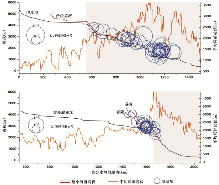
2.1 青藏高原地区青藏高原平均海拔超过4 km,是地球上海拔最高的高原,其整体地貌的基本特征为边缘比较陡,而内部比较平坦[77]。特别受关注的一个科学问题是为什么高原边缘的众多大型河流没有向高原内部进行溯源侵蚀,破坏高原相对平坦的地表及整体性。目前存在若干解释,比如用高原边缘的局部快速隆升和高原隆升导致的“雨影效应”[78]。事实上,雅鲁藏布江(Yarlung Tsangpo)和印度河(Indus River)在青藏高原东西构造结附近均发育了大峡谷,峡谷上游分布大量的堰塞坝[28, 72]。Kourp等[79]通过遥感解译与野外调查在雅鲁藏布江和印度河流域确定了超过900个冰川与滑坡堰塞坝的位置,发现它们与河流裂点的分布具有很好的一致性,推断堰塞作用对保持青藏高原面的完整性起到了重要作用。雅鲁藏布江少而巨的裂点与冰川坝周期性出现在同一位置有关,印度河的裂点相对分散与其流域主要发育的为滑坡坝有关[28, 79]。在印度河和雅鲁藏布江上出现数百个天然水坝明显聚集的现象,河流纵剖面在堰塞坝聚集的地方呈现明显的上凸,并形成河流裂点(图 3)。这两条河流上主要的裂点带(knickzone)上,分布着大小不一的滑坡坝和冰川坝,分别占印度河和雅鲁藏布江整个主河道长度的58 %和16 %,天然筑坝保护了河道基岩不受河流切割的影响,延缓了河流溯源侵蚀以及裂点的迁移,帮助稳定了青藏高原的西南和东南边缘,并在一定程度上保护了青藏高原边缘的完整性[79]。但是,也有研究认为是喜马拉雅东构造结附近2~4 Ma地表的快速抬升,阻止河流裂点溯源迁移从而保持了高原面未受破坏,而非堰塞作用占主导[80],也挑战了认为地表侵蚀主导了构造结地区演化的“构造瘤(tectonic aneurysms)”模式[6]。例如,喀喇昆仑锡亚琴(Siachen)冰川曾经在倒数第二次冰期时阻塞印度河支流什约克河(Shyok River),据沉积物厚度推测堰塞湖持续6~27 ka,但是,目前河流自身已经调整至新的平衡状态,冰川堰塞对其现代河流纵剖面并无显著影响[81]。
|
图 3 印度河和雅鲁藏布江河流纵剖面(据文献[79]修改) Fig. 3 River longitudinal profiles of the Indus and Yarlung Tsangpo rivers, modified from reference[79] |
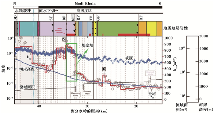
大渡河、雅砻江、金沙江位于青藏高原东缘,河谷深切,形成许多大型峡谷和裂点[82]。Ouimet等[30]通过对长期滑坡坝平均数量和平均高度的控制量化,认为以大滑坡为纽带,坡面侵蚀与河道切割两者存在动态耦合,河流的快速侵蚀下切为发生大型山体滑坡创造了必要条件;反过来,滑坡堆积物长时间覆盖河床,又会减慢或阻止河流进一步侵蚀下切;同时在大渡河和雅砻江以及他们的支流,通过提取其河流纵剖面,发现众多河流裂点均与大滑坡(>105 m3)有关;李海龙等[59, 83]通过对大渡河上的数个古堰塞湖进行光释光测年,结果表明其形成于末次冰期以来并且与区域的构造和气候具有很好的耦合性;而雅砻江支流漓江受大滑坡和坚硬基岩岩性影响,河流纵剖面呈现光滑的、凸起的形状,说明在考虑河流地貌演化过程中,应综合考虑各方面的因素[84]。同样,强烈的新构造运动和区域地质地貌条件使得堵江堰塞事件在金沙江河谷广泛发育,金沙江寨子村及其支流海口的堵江回水区河面弯曲、纵断面比降小、横断面宽而浅,具有平原河流的特征,与非堵江段差异显著[34]。段立曾等[32]认为,堵江堰塞事件发育对金沙江河谷演化的作用与影响大致为以下次序:构造活动及气候异常事件→发生滑坡堵江事件→形成堰塞坝(湖)→堰塞坝(湖)解体消亡→河谷地貌及环境变化→现代金沙江河谷地貌的形成;Walsh等[27]将堰塞坝、陡峭指数(ksn)、断层、基岩数据进行空间叠加,分析裂点的控制因素,认为在喜马拉雅中部莫迪科拉(Modi Khola)山谷地区的河流裂点主要受滑坡大坝的影响,与岩性空间变化和已知的断层无关(图 4)。
|
图 4 莫迪克拉河陡峭指数与堰塞坝、断层和岩性之间的相关性(据文献[27]修改). DD—Deorali拆离;ST—Sinuwa断裂;BF—Bhanuwa断层;MCT—主中央断裂;RF—Romi断层;TF—Tobro断层;GF— Ghandruk断层;RT—Ramgarh断层 Fig. 4 Correlation between the steep index and the barrier dam, the fault and lithology of Modi Khla River, modified from reference[27]. DD, Deorali detachment; ST, Sinuwa thrust; BF, Bhanuwa fault; MCT, Main Central thrust; RF, Romi fault; TF, Tobro fault; GF, Ghandruk fault; RT, Ramgarh thrust |
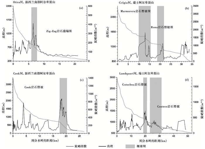
新西兰南部和瑞士阿尔卑斯山均为碰撞造山带,岩性和气候多样性高(降水500~15000 mm/ a)、区内地壳抬升速率(0.1~10 mm/a)差异性大、地震活动频繁,发生了众多大型基岩滑坡和崩塌[26]。两个区域的滑坡非常重要的一个地貌效应是对处于均衡状态的沟道和河流纵剖面的破坏。构造活动和冰川作用奠定了基本的地貌格局,理想化的河流纵剖面形态应如公式(1)所示,但滑坡和瞬时的沉积物供给事件,如泥石流能够在相对平滑的河流纵剖面上制造噪点,使其偏离理想化的形态[85]。因此,利用滑坡分析外部极端地质灾害事件对河流纵剖面发育过程的胁迫作用是可行的[86~88]。另外,高速远程滑坡冲刷侵蚀沟床,随后的碎屑堆积物覆盖沟床表层,形成保护层,消减河流的侵蚀能量,从而减缓河流正常的侵蚀下切速率[63]。
众所周知,河流裂点的形成与大型滑坡存在密不可分的关系,但是鲜见定量化的研究。利用公式(1),θ取构造活跃区的经验值0.45[7],获得陡峭指数ksn的变化趋势[89]。Korup[26, 75]发现,不管所处区域地质构造,气候条件有何差异,山区河流ksn最高值与大型基岩滑坡或者崩塌事件的发生位置具有很好的对应关系(图 5)。某些研究将这种关系解读为坡面过程对区域高速河流下切的快速响应[90]。当然,裂点的形成因素是多样的,比如岩性不同、区域差异性隆升和沉积物供给通量的差异。以陡峭指数等为代表的河流纵剖面形态特征分析,是构造-气候-地貌耦合关系研究的重要技术手段。但是,堵江事件对河流系统的影响长期以来是被忽略的,这可能造成对这些参数的错误解读。
|
图 5 新西兰南部与瑞士阿尔卑斯山河流纵剖面(据文献[26]修改) (a,c)新西兰南部河流纵剖面和陡峭指数、堰塞坝的空间关系图;(b,d)瑞士阿尔卑斯山河流纵剖面和陡峭指数、堰塞坝的空间关系图 Fig. 5 River longitudinal profiles of southern New Zealand and Swiss Alps, modified from reference[26]. (a, c)are spatial diagram of river longitudinal profiles, ksn and dam in southern New Zealand; (b, d)are spatial diagram of river longitudinal profiles, ksn and dam in Swiss Alps |
美国俄勒冈州东部具有特殊的气候-岩性组合,气候相对干燥,地势较低,基岩岩性主要为第三纪和第四纪的火山和火山碎屑岩[91]。因为熔岩流和火山碎屑沉积物覆盖在河流两侧坡体与阶地之上,致使河流两岸容易发生滑坡,而大滑坡可通过改变河道坡度、宽度和河床特征,并以滑坡堆积物填充谷底,从而抑制基岩河道局部的侵蚀下切[58]。Safran等[91]调查了美国东俄勒冈地区德舒特河(Deschutes River)、约翰河(John Day River)、马卢尔河(Malheur River)、奥怀希河(Owyhee River)等4个流域,发现研究区内的17个堰塞湖,其中14个(82 %)以溃坝的方式结束,并在下游形成了多次大型溃决洪水。通过对17个大坝遗址进行详细勘察和测量发现,该地区堰塞坝类型多样,且都是古老的大坝,形成时间约在103~104年,但是无法估计大坝存在的持续时间。该地区的平均坝高和坝体体积均低于其他地区,但由于地形原因,形成的堰塞湖集水面积却很大,这可能是该地区溃决洪水发生的频率高于其他地方的原因[91]。但从目前的河流纵剖面形态来看,仅有4个堰塞坝体使河流纵剖面产生变化,但都与河流裂点的空间相关性很强,这与多数堰塞湖持续时间短,堰塞坝规模小有关,在图 6中,图 6a、6c和6d中的河流纵剖面经过长时间的调整,已经恢复至均衡状态[92],只有图 5b中的约翰河保存着完整的堰塞坝,目前仍有堰塞湖存在,且河流纵剖面发生了明显改变,形成局部上凸,即裂点。这些研究通过已有的资料收集、遥感解译和GIS分析,以及野外调查对一个区域的堰塞坝进行总体分析,主要确定堰塞坝的高度和体积,以及形成的堰塞湖规模等参数,但缺乏对重建结果的可靠性分析,年代更是根据地层关系推测,缺乏绝对定年的支持[88]。
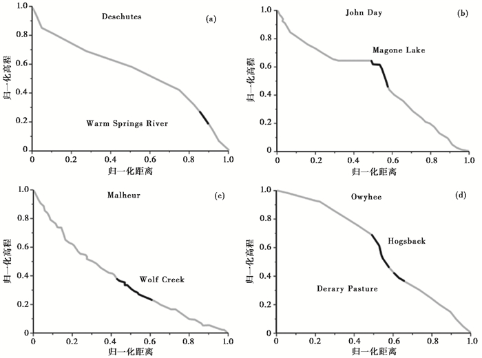
|
图 6 美国东俄勒冈地区河流标准化纵剖面图(据文献[91]修改) 黑色部分为堰塞坝位置;(a,c,d)已溃坝的标准化河流纵剖面,(b)堰塞湖仍存在的标准化河流纵剖面 Fig. 6 Standardized river longitudinal profile in the eastern Oregon region of America, modified from reference[91]. The black part is the location of dam; (a, c, d)are standardized river longitudinal profiles of dam outburst and (b)is standardized river longitudinal profile of dammed lake |
火山熔岩形成的堰塞坝,由于坝体结构的稳定性好,往往持续时间较长,对地貌的影响更为显著[93~95]。土耳其西部的格迪兹河(Gediz River)流域的整体地貌受抬升、气候变化和熔岩筑坝的共同作用,Maddy等[96]绘制了格迪兹河流域熔岩堰塞坝和河流地貌响应简略框架图(图 7),体现了大坝、湖泊、三角洲形成、上游坡度下降和下游坡度增加等过程[97~98]。Gorp等[95]认为库拉熔岩流对格迪兹河流筑坝的响应重建具有两个重要的特征。首先,同一熔岩流造成的多重筑坝,对不同的大坝事件造成不同的河流响应;其次,这些多水坝的破坏可能是作为联级事件发生的,下游的水坝的溃决可能触发了上游的水坝决口。
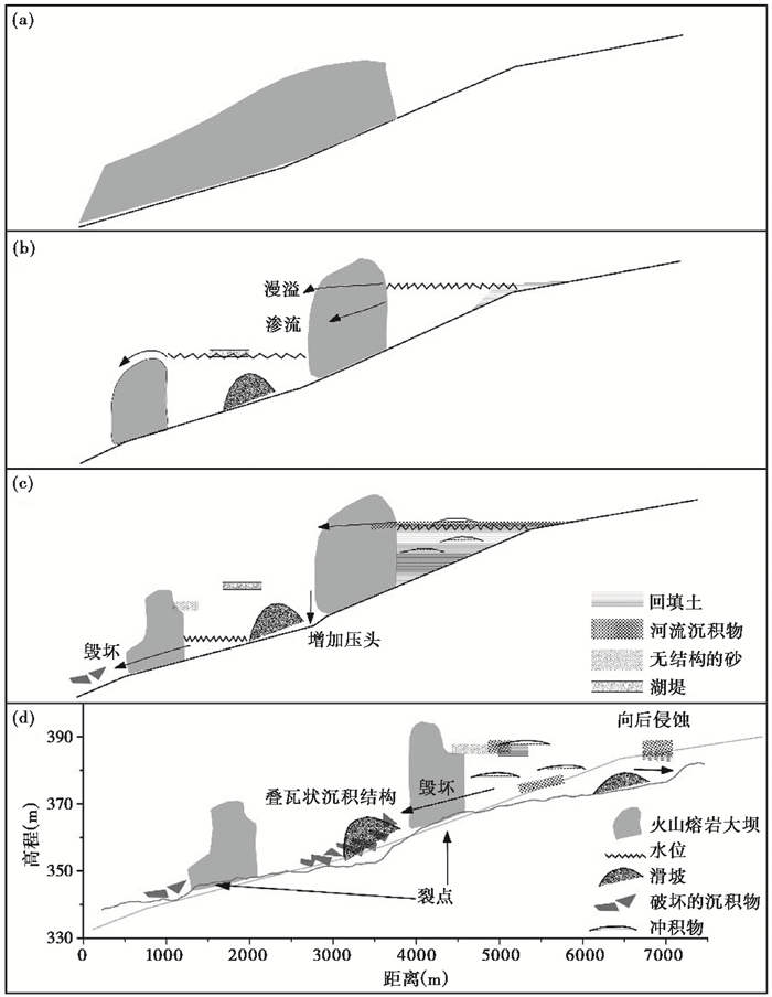
|
图 7 格迪兹河对熔岩筑坝响应示意图(据文献[95~96]修改) (a)~ (d)分别表示河流筑坝和溃坝的过程、河流纵剖面的变化以及裂点形成 Fig. 7 Schematic diagram of the response of the Gediz River to the lava dam, modified from references[95~96]. (a)~(d)represent the processe of damming and dam outburst, the variation of river profile and the formation of knickpoint, respectively |
格伦河(Geren River)是格迪兹河的一个小支流,流域面积约45 km2,在过去的300 ka中经历了多次火山喷发。Gorp等[93~95]对该流域30万年以来形成的5个熔岩堰塞坝进行详细的测年;Schoorl等[99~100]利用LEM LAPSUS这个长时间尺度的景观动态演化模型,模拟了河流的侵蚀和堆积过程,以及格伦河300 ka以来的河流基准面的变化,并绘制了长期的净侵蚀率与有效降雨量之间的相关关系图[93](图 8)。当有效降雨量超过50 mm时,植被发育较好,稳定了土壤,侵蚀系数降低了25 %;如果有效降雨量低于50 mm,由于稳定土壤的植被减少,侵蚀系数增加25 %。Gorp等[93]通过对比格伦河在无大坝、短期大坝和长期大坝这3种情景时的河流基准面的变化情况发现:在无大坝时,河流基准面以0.14 mm/a的速度逐渐降低[101];在有短期大坝和长期大坝时,河流基准面海拔等同于筑坝熔岩的高程。结合野外调查、年代测定和景观演化模型研究表明,格伦河流域至少有3次中更新世筑坝事件。建模表明,长时间的中更新世熔岩坝可以解释所观察到的阻碍切口和随后的切口加积周期;年代久远的河流沉积物与气候构造有关,但由于筑坝事件,由抬升驱动引起的多级阶地形式不存在[93]。
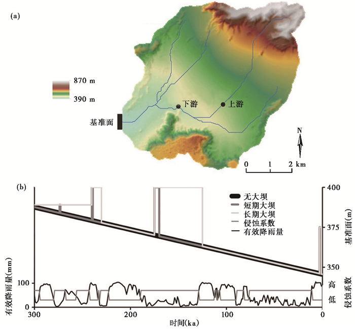
|
图 8 土耳其西部格伦河基准面以及侵蚀系数与有效降雨相关关系(据文献[93]修改) (a)格伦河的DEM河网;(b)无坝、有短期大坝短、有长期大坝、有效降雨和侵蚀系数的基面变化 Fig. 8 Correlation between effective rainfall and erosion coefficient of the base level in western Turkey, modified from reference[93]. (a)is DEM with drainage network of Geren River; (b)is base-level variation without, with short and with long duration dams, effective rainfall and erodibility factor |
河流纵剖面形态特征是河流地貌的重要参数,对其开展深入研究能够帮助我们解释河流地貌演化过程及其影响因素。上述研究案例多位于活动造山带地区,且沟谷深切发育,河谷两侧易发生滑坡、崩塌等地质灾害阻塞河道,使河流纵剖面形成了不规则的上凸,即河流裂点。但不同成因、不同时间尺度和不同规模的堰塞坝,可能会有不同的影响,也并不是每个堰塞堵江事件都对河流纵剖面有显著影响,并造成河流裂点。所以在研究河流堰塞的地貌响应时,需要对堰塞坝的地貌效应进行量化和具体分析,不能一概而论。因此堰塞对河流地貌演化的影响作用不可忽视,探讨河流堰塞的区域地貌影响可为解释河流地貌演化提供新的视角和切入点,主要与堰塞坝对河流纵剖面两种相反的作用方式有关[91]。一方面,堰塞坝将形成局地的侵蚀基准面,造成河道淤积、增加河道的宽度、降低河道的坡度、河道将变成上凸型、形成河流裂点,阻碍了上游河道侵蚀,其影响程度主要取决于堰塞坝的高度和堵江的持续时间;另一方面,堰塞坝溃决往往形成大型/巨型洪水,造成下游河道的剧烈侵蚀,并且溃决后裂点会沿着河道溯源侵蚀,直至河流纵剖面自身调整至平衡状态,这一过程将会促进河流的侵蚀,其影响程度主要取决于溃决洪水规模、次数(一次或者多次溃决)和发生年代。因此,要量化堰塞坝的地貌效应,首先要获取详细的堰塞坝的堵江高度、形成和消亡年代,以及溃决洪水规模、次数等参数。
同时,“堰塞型裂点”也为我们认识河流地貌演化提供了一个全新的视角[27~28, 36, 79]。在更长的时间尺度和空间尺度,一个区域的地貌形态还是由构造活动、岩性和气候等控制因素主导[70, 80, 102~103],但这并不意味着必须忽视极端堰塞事件对河流地貌的影响,尤其是短时间尺度上。相比于正常河流侵蚀搬运堆积过程,极端堰塞事件的侵蚀搬运堆积的速度更快,具有瞬时性。通常情况下,沉积物在输送路径中的持续时间> 103 a[104~105],对于极端堰塞事件来说,可能只是区区几分钟。这种极其快速的侵蚀堆积过程完全具备改变区域地貌演化边界条件的能力。长时间尺度的侵蚀过程,除了冰川作用,包括沟道侵蚀(河流过程和泥石流过程)和非沟道侵蚀(坡面侵蚀)[90, 106~108]。以天然堵江事件为例,堵江体上游会造成区域侵蚀基准面的抬升,造成河流两侧山体侵蚀状态、形态方式和速率的大幅转变;同时,由于坝体对河流搬运能力的控制,其上游地区风化形成的碎屑物最终只能进入堰塞湖库容,无法向下游输送,在上游形成堆积地貌;而一旦堰塞湖溃决,形成溃决洪水,下游则为侵蚀地貌;如果坝体能够保持稳定并持续足够长的时间,其产生的地貌效应可能是河流沟谷在上游地区呈宽谷形态[38]。最后,假设极端堰塞事件在地质历史时期以一定频率重复发生,上述的侵蚀搬运堆积差异量随时间而累积,最终由此产生的地貌差异将会变得非常显著。在研究河流地貌演化过程中,还需将极端堰塞事件与构造、气候等相结合,全面综合的讨论与分析,因此区分河流裂点的类型就显得尤为重要。我们对位于巴基斯坦北部印度河右岸支流吉尔吉特河(Gilgit River)进行了简单的河道分析,得出了河流纵剖面、Chi-plot和坡度-面积双对数图解,发现也可以从这些图上简单区分河流裂点(图 9)。首先从Chi-plot和河流纵剖面图上识别河流裂点,一般裂点的ksn值变化较大且河流纵剖面呈现局部上凸现象。堰塞型裂点的河道坡度仅在裂点附近局部区域陡增,裂点上、下游河道陡峭系数不变。构造型裂点上下游河道陡峭系数发生明显改变,河道坡度增加不仅仅局限在裂点附近。同时,在野外工作中,当看到河流裂点时,如果裂点两端有明显的残余坝体,可认为是由堰塞作用导致的。
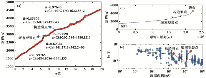
|
图 9 吉尔吉特河河流纵剖面(b)、Chi-plot (a)、坡度-面积双对数图解(c) 高程与Chi(χ)距离的回归系数为河道陡峭指数(ksn),R为高程和χ相关系数,z为高程 Fig. 9 River longitudinal profile (b), Chi-plot (a) and the log-log slope-area plot (c) of Gilgit River. The regression coefficient of elevation and Chi(χ)distance is river steepness index(ksn), R is the correlation coefficient between elevation and χ, and z is the elevation |
极端地表过程在作为突变事件在地貌演化中扮演着重要角色。河流发育过程中除了受到构造、气候等渐变过程的影响[109~113],也受到了堰塞、洪水等极端事件的影响。国内对于河流地貌演化的影响因素,一般认为是由于气候和构造的相互作用导致的[114~116],对堰塞作用为代表的极端事件研究较少涉及[32, 34]。因此本文在简要概述堰塞及其河流地貌响应的基础上,介绍了河流堰塞作用现有的研究方法和案例,以及河流堰塞的发育过程和研究意义。但从现有的研究来看,目前多仅从堰塞坝与河流纵剖面的空间关系的相关性来论证其地貌响应[25~27, 30, 117],并且发现一些堰塞坝与河流纵剖面的相关性[26~27, 30, 74],但是也有一些古堰塞坝对现代河流纵剖面的影响并不显著[81, 91]。这种河流对堰塞的差异地貌响应,原因主要可能与堰塞坝规模、持续时间和距今年代的不同有关,这方面还缺乏深入和量化研究。可对单个的堰塞坝进行详细的规模、持续年代等关键参数的重建,获取其河流裂点、陡峭指数等地貌参数,并分析裂点形成的原因,建立堰塞事件的地貌响应数值模拟模型。同时后续研究应该仔细探讨如何区分堰塞裂点、构造裂点、气候因素导致的基准面变化形成的裂点、岩性差异形成的裂点,分析不同类型的河流裂点在地貌演化中的作用,最终获得合理的区域地貌演化模式。
致谢: 非常感谢杨羽帆同学对论文部分作图的帮助以及胡旭东师兄对英文摘要修改的帮助;感谢中国地震局地质研究所王一舟师兄的有益指导和讨论;感谢审稿专家以及编辑部赵淑君和杨美芳老师建设性的修改意见。
| [1] |
Beaumont C, Jamieson R A, Nguyen M H, et al. Himalayan tectonics explained by extrusion of a low-viscosity crustal channel coupled to focused surface denudation[J]. Nature, 2001, 414(6865): 738-742. DOI:10.1038/414738a |
| [2] |
Burbank D W, Anderson R S. Tectonic geomorphology[J]. Environmental Engineering Geoscience, 2013, 19(2): 198-200. DOI:10.2113/gseegeosci.19.2.198 |
| [3] |
Liu-Zeng J, Tapponnier P, Gaudemer Y, et al. Quantifying landscape differences across the Tibetan Plateau:Implications for topographic relief evolution[J]. Journal of Geophysical Research:Earth Surface (2003-2012), 2008, 113: F04018. DOI:10.1029/2007JF000897 |
| [4] |
Molnar P, England P. Late Cenozoic uplift of mountain ranges and global climate change:Chicken or egg?[J]. Nature, 1990, 346(6279): 29-34. DOI:10.1038/346029a0 |
| [5] |
Montgomery D R, Balco G, Willett S D. Climate, tectonics, and the morphology of the Andes[J]. Geology, 2001, 29(7): 579-582. DOI:10.1130/0091-7613(2001)029<0579:CTATMO>2.0.CO;2 |
| [6] |
Zeitler P K, Meltzer A S, Koons P O, et al. Erosion, Himalayan geodynamics, and the geomorphology of metamorphism[J]. GSA Today, 2001, 11(1): 4-9. DOI:10.1130/1052-5173(2001)011<0004:EHGATG>2.0.CO;2 |
| [7] |
Whipple K X. Bedrock rivers and the geomorphology of active orogens[J]. Annual Review of Earth and Planetary Sciences, 2004, 32(1): 151-185. DOI:10.1146/annurev.earth.32.101802.120356 |
| [8] |
潘保田, 邬光剑, 王义祥, 等. 祁连山东段沙沟河阶地的年代与成因[J]. 科学通报, 2000, 45(24): 2669-2675. Pan Baotian, Wu Guangjian, Wang Yixiang, et al. The age and formation of shagou river terrace in the eastern part of Qilian Mountain[J]. Chinese Science Bulletin, 2000, 45(24): 2669-2675. DOI:10.3321/j.issn:0023-074X.2000.24.019 |
| [9] |
王一舟, 张会平, 郑德文, 等. 基岩河道河流水力侵蚀模型及其应用:兼论青藏高原基河道研究的迫切性[J]. 第四纪研究, 2016, 36(4): 884-897. Wang Yizhou, Zhang Huiping, Zheng Dewen, et al. Bedrock channel stream-power incision model and its application:The urgency of bedrock channel research in Tibetan Plateau[J]. Quaternary Sciences, 2016, 36(4): 884-897. |
| [10] |
王一舟, 张会平, 俞晶星, 等. 祁连山洪水坝河流域地貌特征及其构造指示意义[J]. 第四纪研究, 2013, 33(4): 737-745. Wang Yizhou, Zhang Huiping, Yu Jingxing, et al. Geomorphic features of the Hongshuiba river drainage basin in Qilianshan Mountain and its insight into tectonic implications[J]. Quaternary Sciences, 2013, 33(4): 737-745. DOI:10.3969/j.issn.1001-7410.2013.04.11 |
| [11] |
王一舟, 张会平, 郑德文, 等. 非均衡河道高程剖面及其蕴含的构造活动信息[J]. 第四纪研究, 2018, 38(1): 220-231. Wang Yizhou, Zhang Huiping, Zheng Dewen, et al. River longitudinal profiles under transient state and the related tectonic signals[J]. Quaternary Sciences, 2018, 38(1): 220-231. |
| [12] |
Goren L, Fox M, Willett S D. Tectonics from fluvial topography using formal linear inversion:Theory and applications to the Inyo Mountains, California[J]. Journal of Geophysical Research:Earth Surface, 2014, 119(8): 1651-1681. DOI:10.1002/2014JF003079 |
| [13] |
Kirby E, Whipple K. Quantifying differential rock-uplift rates via stream profile analysis[J]. Geology, 2001, 29(5): 415-418. DOI:10.1130/0091-7613(2001)029<0415:QDRURV>2.0.CO;2 |
| [14] |
Wang Yizhou, Zhang Huiping, Zheng Dewen, et al. How a stationary knickpoint is sustained:New insights into the formation of the deep Yarlung Tsangpo Gorge[J]. Geomorphology, 2017, 285: 28-43. DOI:10.1016/j.geomorph.2017.02.005 |
| [15] |
Willett S D, McCoy S W, Perron J T, et al. Dynamic Reorganization of River Basins[J]. Science, 2014, 343(6175): 1248765. DOI:10.1126/science.1248765 |
| [16] |
Yang R, Willett S D, Goren L. In situ low-relief landscape formation as a result of river network disruption[J]. Nature, 2015, 520(7548): 526-529. DOI:10.1038/nature14354 |
| [17] |
胡小飞, 潘保田, Kirby E, 等. 河道陡峭指数所反映的祁连山北翼抬升速率的东西差异[J]. 科学通报, 2010, 55(23): 3205-3214. Hu Xiaofei, Pan Baotian, Kirby E, et al. Spatial differences in rock uplift rates inferred from channel steepness indices along the northern flank of the Qilian Mountain, northeast Tibetan Plateau[J]. Chinese Science Bulletin, 2010, 55(23): 3205-3214. |
| [18] |
张会平, 张培震, 樊祺诚. 河流裂点的发育及其溯源迁移:以鸭绿江-望天鹅火山区为例[J]. 中国科学:地球科学, 2011(11): 1627-1635. Zhang Huiping, Zhang Peizhen, Fan Qicheng. Initiation and recession of the fluvial knickpoints:A case study from the Yalu River-Wangtian'e volcanic region, Northeastern China[J]. Science China:Earth Sciences, 2011(11): 1627-1635. |
| [19] |
程璐, 武登云, 靳文, 等. 基于地貌计量指标分析的钱塘江流域地貌演化特征[J]. 第四纪研究, 2017, 37(2): 343-352. Cheng Lu, Wu Dengyun, Jin Wen, et al. Geomorphic evolution of the Qiantang River drainage basin based on the analysis of topographic indexs[J]. Quaternary Sciences, 2017, 37(2): 343-352. |
| [20] |
刘蓓蓓, 崔之久, 刘耕年, 等. 基于面积-高程积分法的岷山雪宝顶-九寨沟地貌形态分析[J]. 第四纪研究, 2017, 37(2): 224-233. Liu Beibei, Cui Zhijiu, Liu Gengnian, et al. Geomorphologic analysis of the Xuebaoding-Jiuzhaigou area in Min Shan based on Hypsometric Integral method[J]. Quaternary Sciences, 2017, 37(2): 224-233. |
| [21] |
肖萍, 刘静, 王伟, 等. 青藏高原东南缘芒康地区河流地貌演化的磷灰石U-Th/He记录[J]. 第四纪研究, 2015, 35(2): 433-444. Xiao Ping, Liu Jing, Wang Wei, et al. The evoluiton of fluvial geomorphology of Mangkang area (southeastern Tibetan Plateau) recorded by apatite U-Th/He thermochronology[J]. Quaternary Sciences, 2015, 35(2): 433-444. |
| [22] |
陈建军, 季建清, 余绍立. 基岩河道流域地貌研究的定量计算方法及其进展[J]. 地质科技情报, 2008, 27(4): 39-48. Chen Jianjun, Ji Jianqing, Yu Shaoli. Quantitative analysis and significance of bedrock channel fluvial landscape response time scale[J]. Geological Science and Technology Information, 2008, 27(4): 39-48. DOI:10.3969/j.issn.1000-7849.2008.04.007 |
| [23] |
李小强, 王军, 熊仁伟, 等. 六盘山地区河道陡峭指数对隆升速率差异的响应[J]. 第四纪研究, 2016, 36(2): 443-452. Li Xiaoqiang, Wang Jun, Xiong Renwei, et al. The response of the change channel steepness index to the difference of uplift rate in the Liupanshan Mountain area[J]. Quaternary Sciences, 2016, 36(2): 443-452. |
| [24] |
赵洪壮, 李有利, 杨景春, 等. 天山北麓河流纵剖面与基岩侵蚀模型特征分析[J]. 地理学报, 2009, 64(5): 563-570. Zhao Hongzhuang, Li Youli, Yang Jingchun, et al. The longitudinal profiles of the ten rivers in north Tianhan Mountains and their tectonic significance[J]. Acta Geographica Sinica, 2009, 64(5): 563-570. DOI:10.3321/j.issn:0375-5444.2009.05.005 |
| [25] |
Hewitt K. Catastrophic landslides and their effects on the Upper Indus streams, Karakoram Himalaya, Northern Pakistan[J]. Geomorphology, 1998, 26(1): 47-80. |
| [26] |
Korup O. Rock-slope failure and the river long profile[J]. Geology, 2006, 34(1): 45-48. DOI:10.1130/G21959.1 |
| [27] |
Walsh L S, Martin A J, Ojha T P, et al. Correlations of fluvial knickzones with landslide dams, lithologic contacts, and faults in the southwestern Annapurna Range, central Nepalese Himalaya[J]. Journal of Geophysical Research:Earth Surface, 2012, 117: F01012. DOI:10.1029/2011JF001984 |
| [28] |
Korup O, Montgomery D R. Tibetan Plateau river incision inhibited by glacial stabilization of the Tsangpo gorge[J]. Nature, 2008, 455(7214): 786-789. DOI:10.1038/nature07322 |
| [29] |
Hewitt K. Disturbance regime landscapes:Mountain drainage systems interrupted by large rockslides[J]. Progress in Physical Geography, 2006, 30(3): 365-393. DOI:10.1191/0309133306pp486ra |
| [30] |
Ouimet W B, Whipple K X, Royden L H, et al. The influence of large landslides on river incision in a transient landscape:Eastern margin of the Tibetan Plateau (Sichuan, China)[J]. Geological Society of America Bulletin, 2007, 119(11-12): 1462-1476. DOI:10.1130/B26136.1 |
| [31] |
柴贺军. 大型天然水体的环境效应研究[J]. 地质灾害与环境保护, 1998, 9(2): 7-12. Chai Hejun. Research on the environmental effects of large scale natural water body[J]. Journal of Geological Hazards and Environment Preservation, 1998, 9(2): 7-12. |
| [32] |
段立曾, 明庆忠, 张虎才, 等. 金沙江堵江堰塞事件及其地貌环境效应研究进展[J]. 地球科学前沿, 2013, 3(1): 8-17. Duan Lizeng, Ming Qingzhong, Zhang Hucai, et al. Research progress of landslide dam events of Jinsha River and its geomorphologic and environmental effects[J]. Advances in Geosciences, 2013, 3(1): 8-17. |
| [33] |
李海龙, 张岳桥. 滑坡型堰塞湖形成与保留条件分析——基于文献总结和青藏高原东缘南北向深切河谷研究[J]. 第四纪研究, 2015, 35(1): 71-87. Li Hailong, Zhang Yueqiao. Analysis of the controlling factors of landslide damming and dam failure:An analysis based on literature review and the study on the meridional river system of eastern Tibetan Plateau[J]. Quaternary Sciences, 2015, 35(1): 71-87. |
| [34] |
徐则民, 刘文连, 黄润秋. 滑坡堵江的地貌效应[J]. 第四纪研究, 2013, 33(3): 490-500. Xu Zemin, Liu Wenlian, Huang Runqiu. Geomorphological effects of landslide damming[J]. Quaternary Sciences, 2013, 33(3): 490-500. DOI:10.3969/j.issn.1001-7410.2013.03.09 |
| [35] |
余国安, 王兆印, 黄河清, 等. 崩滑堰塞坝(湖)的地貌环境效应[J]. 地球科学进展, 2010, 25(9): 934-940. Yu Guo'an, Wang Zhaoyin, Huang Heqing, et al. Geomorphology and environment effects of landslide dams (dammed lakes)[J]. Advances in Earth Science, 2010, 25(9): 934-940. |
| [36] |
张康, 王兆印, 刘怀湘, 等. 裂点发育及其对堰塞坝的稳定性影响[J]. 山地学报, 2011, 29(4): 474-482. Zhang Kang, Wang Zhaoyin, Liu Huaixiang, et al. Effect of knickpoint development in controlling the stability of the landslide dam[J]. Journal of Mountain Science, 2011, 29(4): 474-482. DOI:10.3969/j.issn.1008-2786.2011.04.012 |
| [37] |
Hermanns R L, Niedermann S, Ivy-Ochs S, et al. Rock avalanching into a landslide-dammed lake causing multiple dam failure in Las Conchas valley (NW Argentina)-Evidence from surface exposure dating and stratigraphic analyses[J]. Landslides, 2004, 1(2): 113-122. |
| [38] |
Liu Weiming, Lai Zhongping, Hu Kaiheng, et al. Age and extent of a giant glacial-dammed lake at Yarlung Tsangpo gorge in the Tibetan Plateau[J]. Geomorphology, 2015, 246: 370-376. DOI:10.1016/j.geomorph.2015.06.034 |
| [39] |
Pánek T, Hradecký J, Smolková V, et al. The largest prehistoric landslide in Northwestern Slovakia:Chronological constraints of the Kykula long-runout landslide and related dammed lakes[J]. Geomorphology, 2010, 120(3-4): 233-247. DOI:10.1016/j.geomorph.2010.03.033 |
| [40] |
Pratt-Sitaula B, Garde M, Burbank D W, et al. Bedload-to- suspended load ratio and rapid bedrock incision from Himalayan landslide-dam lake record[J]. Quaternary Research, 2007, 68(1): 111-120. DOI:10.1016/j.yqres.2007.03.005 |
| [41] |
Reneau S L, Dethier D P. Late Pleistocene landslide-dammed lakes along the Rio Grande, White Rock Canyon, New Mexico[J]. Geological Society of America Bulletin, 1996, 108(11): 1492-1507. DOI:10.1130/0016-7606(1996)108<1492:LPLDLA>2.3.CO;2 |
| [42] |
Wu Q, Zhao Z, Liu L, et al. Outburst flood at 1920 BCE supports historicity of China's Great Flood and the Xia Dynasty[J]. Science, 2016, 353(6299): 579-582. DOI:10.1126/science.aaf0842 |
| [43] |
Mackey B H, Roering J J, Lamb M P. Landslide-dammed paleolake perturbs marine sedimentation and drives genetic change in anadromous fish[J]. Proceedings of the National Academy of Sciences of the United States of America, 2011, 108(47): 18905. DOI:10.1073/pnas.1110445108 |
| [44] |
陈剑, 崔之久. 金沙江上游雪隆囊古滑坡堰塞湖溃坝堆积体的发现及其环境与灾害意义[J]. 沉积学报, 2015, 33(2): 275-284. Chen Jian, Cui Zhijiu. Discovery of outburst deposits induced by the Xuelongnang paleolandslide-dammed lake in the upper Jinsha River, China and its environmental and hazard significance[J]. Acta Sedimentologica Sinica, 2015, 33(2): 275-284. |
| [45] |
朱正峰, 苏怀, 董铭, 等. 金沙江寨子村古堰塞湖沉积年代研究[J]. 第四纪研究, 2018, 38(1): 145-150. Zhu Zhengfeng, Su Huai, Dong Ming, et al. The age of Zhaizicun ancient dammed lake sediments in Jinsha River[J]. Quaternary Sciences, 2018, 38(1): 145-150. |
| [46] |
Clague J J, Evans S G. A review of catastrophic drainage of moraine-dammed lakes in British Columbia[J]. Quaternary Science Reviews, 2000, 19(17-18): 1763-1783. DOI:10.1016/S0277-3791(00)00090-1 |
| [47] |
刘宁, 程尊兰, 崔鹏, 等. 堰塞湖及其风险控制[M]. 北京: 科学出版社, 2013: 1-7. Liu Ning, Cheng Zunlan, Cui Peng, et al. Dammed Lake and Risk Management[M]. Beijing: Science Press, 2013: 1-7. |
| [48] |
Costa J E, Schuster R L. The formation and failure of natural dams[J]. Geological Society of America Bulletin, 1988, 100(7): 1054-1068. DOI:10.1130/0016-7606(1988)100<1054:TFAFON>2.3.CO;2 |
| [49] |
O'Connor J E, Clague J J, Walder J S, et al. 9.25 Outburst floods[J]. Treatise on Geomorphology, 2013, 9: 475-510. DOI:10.1016/B978-0-12-374739-6.00251-7 |
| [50] |
王欣, 刘时银. 冰碛湖溃决灾害研究进展[J]. 冰川冻土, 2007, 29(4): 626-635. Wang Xin, Liu Shiyin. An overview of researches on moraine-dammed lake outburst flood hazards[J]. Journal of Glaciology and Geocryology, 2007, 29(4): 626-635. DOI:10.3969/j.issn.1000-0240.2007.04.017 |
| [51] |
Zhang Guoqing, Yao Tandong, Xie Hongjie, et al. An inventory of glacial lakes in the Third Pole region and their changes in response to global warming[J]. Global and Planetary Change, 2015, 131: 148-157. DOI:10.1016/j.gloplacha.2015.05.013 |
| [52] |
Whipple K X. River incision into bedrock:Mechanics and relative efficacy of plucking, abrasion, and cavitation[J]. Geological Society of America Bulletin, 2000, 112(3): 490-503. DOI:10.1130/0016-7606(2000)112<490:RIIBMA>2.0.CO;2 |
| [53] |
陈彦杰, 宋国城, 陈昭男. 非均衡山脉的河流水力侵蚀模型[J]. 科学通报, 2006, 51(7): 865-869. Chen Yanjie, Song Guocheng, Chen Zhaonan. Stream-power incision model of unbalanced mountain range[J]. Chinese Science Bulletin, 2006, 51(7): 865-869. DOI:10.3321/j.issn:0023-074X.2006.07.019 |
| [54] |
李雪梅, 张会平. 河流瞬时地貌:特征、过程及其构造-气候相互作用内涵[J]. 第四纪研究, 2017, 37(2): 416-430. Li Xuemei, Zhang Huiping. Transient fluvial landscpe:Features, processes and its implication for tectonic-climate interaction[J]. Quaternary Sciences, 2017, 37(2): 416-430. |
| [55] |
张会平, 张培震, 吴庆龙, 等. 循化-贵德地区黄河水系河流纵剖面形态特征及其构造意义[J]. 第四纪研究, 2008, 28(2): 299-309. Zhang Huiping, Zhang Peizhen, Wu Qinglong, et al. Characteristics of the huanghe river longitudinal profiles around Xunhua-Guide area(NE Tibet) and their tectonic significance[J]. Quaternary Sciences, 2008, 28(2): 299-309. DOI:10.3321/j.issn:1001-7410.2008.02.012 |
| [56] |
Owen L A. Geomorphology:How Tibet might keep its edge[J]. Nature, 2008, 455(7214): 748-749. DOI:10.1038/455748a |
| [57] |
Safran E B, Anderson R S, Riihimaki C A, et al. Longitudinal stream profile morphology and patterns of knickpoint propagation in the Bighorn Range[C]. AGU Fall Meeting Abstracts, 2005: H34A-08. https://www.researchgate.net/publication/252404988_Longitudinal_Stream_Profile_Morphology_and_Patterns_of_Knickpoint_Propagation_in_the_Bighorn_Range
|
| [58] |
Safran E B, Peden D, Harrity K, et al. Impact of Landslide Dams on River Profile Evolution[C]. AGU Fall Meeting Abstracts, 2008: H54D-03. https://www.researchgate.net/publication/234550975_Impact_of_Landslide_Dams_on_River_Profile_Evolution
|
| [59] |
李海龙, 张岳桥, 李建华. 青藏高原东缘南北向河流系统及其伴生古堰塞湖研究[J]. 第四纪研究, 2010, 30(4): 812-824. Li Hailong, Zhang Yueqiao, Li Jianhua. Meridional river systems and ancient dammed lakes on the east margin of the Tibetan Plateau[J]. Quaternary Sciences, 2010, 30(4): 812-824. DOI:10.3969/j.issn.1001-7410.2010.04.16 |
| [60] |
Baker V R, Bunker R C. Cataclysmic Late Pleistocene flooding from glacial Lake Missoula:A review[J]. Quaternary Science Reviews, 1985, 4(1): 1-41. DOI:10.1016/0277-3791(85)90027-7 |
| [61] |
Carling P A. Freshwater megaflood sedimentation:What can we learn about generic processes?[J]. Earth-Science Reviews, 2013, 125(125): 87-113. |
| [62] |
Hanson M A, Lian O B, Clague J J. The sequence and timing of large Late Pleistocene floods from glacial Lake Missoula[J]. Quaternary Science Reviews, 2012, 31(1): 67-81. |
| [63] |
Shang Y, Yang Z, Li L, et al. A super-large landslide in Tibet in 2000:Background, occurrence, disaster, and origin[J]. Geomorphology, 2003, 54(3-4): 225-243. DOI:10.1016/S0169-555X(02)00358-6 |
| [64] |
Baker V R. High-Energy Megafloods: Planetary Settings and Sedimentary Dynamics[M]//Martini I P, Baker V R, Garzon G. Flood and Megaflood Feposits: Recent and Ancient Examples. International Association of Sedimentologists Special Publication, 2002: 1-15.
|
| [65] |
Lang K A, Huntington K W, Montgomery D R. Erosion of the Tsangpo Gorge by megafloods, eastern Himalaya[J]. Geology, 2013, 41(9): 1003-1006. DOI:10.1130/G34693.1 |
| [66] |
Cui Peng, Chen Xiaoqing, Zhu Yingyan, et al. The Wenchuan earthquake (May 12, 2008), Sichuan Province, China, and resulting geohazards[J]. Natural Hazards, 2011, 56(1): 19-36. DOI:10.1007/s11069-009-9392-1 |
| [67] |
黄润秋. 汶川地震地质灾害研究[M]. 北京: 科学出版社, 2009: 356-356. Huang Runqiu. Geohazard Assessment of the Wenchuan Earthquake[M]. Beijing: Science Press, 2009: 356-356. |
| [68] |
Safran E B, Bierman P R, Aalto R, et al. Erosion rates driven by channel network incision in the Bolivian Andes[J]. Earth Surface Processes and Landforms, 2005, 30(8): 1007-1024. DOI:10.1002/(ISSN)1096-9837 |
| [69] |
Whipple K X, Tucker G E. Dynamics of the stream-power river incision model:Implications for height limits of mountain ranges, landscape response timescales, and research needs[J]. Journal of Geophysical Research:Solid Earth, 1999, 104(B8): 17661-17674. DOI:10.1029/1999JB900120 |
| [70] |
刘静, 张金玉, 葛玉魁, 等. 构造地貌学:构造-气候-地表过程相互作用的交叉研究[J]. 科学通报, 2018, 63(30): 3070-3088. Liu-Zeng Jing, Zhang Jinyu, Ge Yukui, et al. Tectonic geomorphology:An interdisciplinary study of the interaction among tectonic climatic and surface processes[J]. Chinese Science Bulletin, 2018, 63(30): 3070-3088. |
| [71] |
张新钰, 季建清, 韩宝福, 等. 地表剥蚀、下地壳流变与造山作用研究进展[J]. 地球科学进展, 2006, 21(5): 521-531. Zhang Xinyu, Ji Jianqing, Han Baofu, et al. Research advances in erosion, rheology of the lower crust and orogeny[J]. Advances in Earth Science, 2006, 21(5): 521-531. DOI:10.3321/j.issn:1001-8166.2006.05.011 |
| [72] |
Hewitt K. Catastrophic rock slope failures and Late Quaternary developments in the Nanga Parbat-Haramosh Massif, Upper Indus basin, Northern Pakistan[J]. Quaternary Science Reviews, 2009, 28(11-12): 1055-1069. DOI:10.1016/j.quascirev.2008.12.019 |
| [73] |
Hewitt K. Rock Avalanche Dams on the Trans Himalayan Upper Indus Streams: A survey of Late Quaternary events and hazard- related characteristics[M]//Natural and Artificial Rockslide Dams. Berlin Heidelberg: Springer, 2011: 177-204.
|
| [74] |
Korup O, Strom A L, Weidinger J T. Fluvial response to large rock-slope failures:Examples from the Himalayas, the Tien Shan, and the Southern Alps in New Zealand[J]. Geomorphology, 2006, 78(1-2): 3-21. DOI:10.1016/j.geomorph.2006.01.020 |
| [75] |
Korup O. Effects of large deep-seated landslides on hillslope morphology, western Southern Alps, New Zealand[J]. Journal of Geophysical Research, 2006, 111: F01018. DOI:10.1029/2004JF000242 |
| [76] |
Penna I M, Hermanns R L, Daicz S, et al. Effects of tectonic deformation and landslides in the erosion of a mountain plateau in the transitional zone between the Central and Patagonian Andes[J]. American Journal of Science, 2015, 315(3): 257-274. DOI:10.2475/03.2015.03 |
| [77] |
Fielding E, Isacks B, Barazangi M, et al. How flat is Tibet?[J]. Geology, 1994, 22(2): 163-167. DOI:10.1130/0091-7613(1994)022<0163:HFIT>2.3.CO;2 |
| [78] |
Sobel E R, Hilley G E, Strecker M R. Formation of internally drained contractional basins by aridity-limited bedrock incision[J]. Journal of Geophysical Research:Solid Earth, 2003, 108(B7): 2344. DOI:10.1029/2002JB001883 |
| [79] |
Korup O, Montgomery D R, Hewitt K. Glacier and landslide feedbacks to topographic relief in the Himalayan syntaxes[J]. Proceedings of the National Academy of Sciences of the United States of America, 2010, 107(12): 5317-5322. DOI:10.1073/pnas.0907531107 |
| [80] |
Wang P, Scherler D, Liu-Zeng J, et al. Tectonic control of Yarlung Tsangpo Gorge revealed by a buried canyon in southern Tibet[J]. Science, 2014, 346(6212): 978-981. DOI:10.1126/science.1259041 |
| [81] |
Scherler D, Munack H, Mey J, et al. Ice dams, outburst floods, and glacial incision at the western margin of the Tibetan Plateau:A > 100k. y. chronology from the Shyok Valley, Karakoram[J]. Geological Society of America Bulletin, 2014, 126(5-6): 738-758. DOI:10.1130/B30942.1 |
| [82] |
Yang R, Fellin M G, Herman F, et al. Spatial and temporal pattern of erosion in the Three Rivers region, southeastern Tibet[J]. Earth and Planetary Science Letters, 2016, 433: 10-20. DOI:10.1016/j.epsl.2015.10.032 |
| [83] |
李海龙, 张岳桥, 乔彦松, 等. 青藏高原东缘大渡河中游深切河谷沉积物及其地震地质意义[J]. 地质通报, 2015, 34(1): 104-112. Li Hailong, Zhang Yueqiao, Qiao Yansong, et al. A study of the sediments in the middle reaches of the Dadu River on the eastern margin of the Tibetan Plateau and its seismogeological implications[J]. Geological Bulletin of China, 2015, 34(1): 104-112. DOI:10.3969/j.issn.1671-2552.2015.01.008 |
| [84] |
Begin Z E B, Meyer D F, Schumm S A. Knickpoint migration due to baselevel lowering[J]. Journal of the Waterway Port Coastal and Ocean Division, 1980, 106(3): 369-388. |
| [85] |
Benda L, Veldhuisen C, Black J. Debris flows as agents of morphological heterogeneity at low-order confluences, Olympic Mountains, Washington[J]. Geological Society of America Bulletin, 2003, 115(9): 1110-1121. DOI:10.1130/B25265.1 |
| [86] |
Cui Y, Parker G, Lisle T E, et al. Sediment pulses in mountain rivers:1. Experiments[J]. Water Resources Research, 2003, 39(9): 381-386. |
| [87] |
Korup O, McSaveney M J, Davies T R H. Sediment generation and delivery from large historic landslides in the Southern Alps, New Zealand[J]. Geomorphology, 2004, 61(1-2): 189-207. DOI:10.1016/j.geomorph.2004.01.001 |
| [88] |
Schlunegger F. Impact of hillslope-derived sediment supply on drainage basin development in small watersheds at the northern border of the central Alps of Switzerland[J]. Geomorphology, 2002, 46(3-4): 285-305. DOI:10.1016/S0169-555X(02)00081-8 |
| [89] |
Hodges K V, Wobus C, Ruhl K, et al. Quaternary deformation, river steepening, and heavy precipitation at the front of the Higher Himalayan ranges[J]. Earth and Planetary Science Letters, 2004, 220(3-4): 379-389. DOI:10.1016/S0012-821X(04)00063-9 |
| [90] |
Lague D, Davy P. Constraints on the long-term colluvial erosion law by analyzing slope-area relationships at various tectonic uplift rates in the Siwaliks Hills (Nepal)[J]. Journal of Geophysical Research:Solid Earth, 2003, 108(B2): 2129. DOI:10.1029/2002JB001893 |
| [91] |
Safran E B, O'Connor J E, Ely L L, et al. Plugs or flood-makers? The unstable landslide dams of eastern Oregon[J]. Geomorphology, 2015, 248: 237-251. DOI:10.1016/j.geomorph.2015.06.040 |
| [92] |
O'Connor J E, Curran J H, Beebee R A, et al. Quaternary Geology and Geomorphology of the Lower Deschutes River Canyon, Oregon[M]//O'Connor J E, Grant G E eds. A Peculiar River. New York: American Geophysical Union, 2013: 73-94.
|
| [93] |
Gorp W V, Schoorl J M, Temme A J A M, et al. Catchment response to lava damming:Integrating field observation, geochronology and landscape evolution modelling[J]. Earth Surface Processes and Landforms, 2016, 41(11): 1629-1644. DOI:10.1002/esp.v41.11 |
| [94] |
Gorp W V, Temme A J A M, Veldkamp A, et al. Modelling long-term (300 ka) upland catchment response to multiple lava damming events[J]. Earth Surface Processes and Landforms, 2015, 40(7): 888-900. DOI:10.1002/esp.3689 |
| [95] |
Gorp W V, Veldkamp A, Temme A J A M, et al. Fluvial response to Holocene volcanic damming and breaching in the Gediz and Geren rivers, Western Turkey[J]. Geomorphology, 2013, 201(3): 430-448. |
| [96] |
Maddy D, Demir T, Bridgland D R, et al. The Pliocene initiation and Early Pleistocene volcanic disruption of the palaeo-Gediz fluvial system, Western Turkey[J]. Quaternary Science Reviews, 2007, 26(22-24): 2864-2882. DOI:10.1016/j.quascirev.2006.01.037 |
| [97] |
Baartman J E M, Veldkamp A, Schoorl J M, et al. Oral presentation:Unravelling Late Pleistocene and Holocene landscape dynamics:The Upper Guadalentín Basin, SE Spain[J]. Geomorphology, 2011, 125(1): 172-185. DOI:10.1016/j.geomorph.2010.09.013 |
| [98] |
Crow R, Karlstrom K E, Mcintosh W, et al. History of Quaternary volcanism and lava dams in western Grand Canyon based on lidar analysis, 40Ar/39Ar dating, and field studies:Implications for flow stratigraphy, timing of volcanic events, and lava dams[J]. Geosphere, 2008, 4(1): 183-206. DOI:10.1130/GES00133.1 |
| [99] |
Schoorl J M, Sonneveld M P W, Veldkamp A. Three-dimensional landscape process modelling:The effect of DEM resolution[J]. Earth Surface Processes and Landforms, 2000, 25(9): 1025-1034. DOI:10.1002/(ISSN)1096-9837 |
| [100] |
Schoorl J M, Veldkamp A, Bouma J. Modeling water and soil redistribution in a dynamic landscape context[J]. Soil Science Society of America Journal, 2002, 66(5): 1610-1619. DOI:10.2136/sssaj2002.1610 |
| [101] |
Maddy D, Demir T, Veldkamp A, et al. The obliquity-controlled Early Pleistocene terrace sequence of the Gediz River, western Turkey:A revised correlation and chronology[J]. Journal of the Geological Society, 2012, 169(1): 67-82. DOI:10.1144/0016-76492011-011 |
| [102] |
张金玉, 刘静, 王伟, 等. 活动造山带地区河流阶地与下切速率及其时空分布样式[J]. 第四纪研究, 2018, 38(1): 204-219. Zhang Jinyu, Liu-Zeng Jing, Wang Wei, et al. Fluvial terraces and river incision rates in active orogen and their spatial and temporal pattern[J]. Quaternary Sciences, 2018, 38(1): 204-219. |
| [103] |
李晓峰, 王萍, 王慧颖, 等. 雅鲁藏布江大拐弯地区河流地貌参数揭示的地质构造意义[J]. 第四纪研究, 2018, 38(1): 183-192. Li Xiaofeng, Wang Ping, Wang Huiying, et al. Differential tectonic uplift indicated by river geomorphic parameters at the Tsangpo River Gorge[J]. Quaternary Sciences, 2018, 38(1): 183-192. |
| [104] |
Bhattacharya J P, Copeland P, Lawton T F, et al. Estimation of source area, river paleo-discharge, paleoslope, and sediment budgets of linked deep-time depositional systems and implications for hydrocarbon potential[J]. Earth-Science Reviews, 2016, 153: 77-110. DOI:10.1016/j.earscirev.2015.10.013 |
| [105] |
Hoffmann T. Sediment residence time and connectivity in non- equilibrium and transient geomorphic systems[J]. Earth-Science Reviews, 2015, 150: 609-627. DOI:10.1016/j.earscirev.2015.07.008 |
| [106] |
Montgomery D R, Dietrich W E. Channel initiation and the problem of landscape scale[J]. Science, 1992, 255(5046): 826. DOI:10.1126/science.255.5046.826 |
| [107] |
Stock J, Dietrich W E. Valley incision by debris flows:Evidence of a topographic signature[J]. Water Resources Research, 2003, 39(4): 1089. DOI:10.1029/2001WR001057 |
| [108] |
Tucker G E, Bras R L. Hillslope processes, drainage density, and landscape morphology[J]. Water Resources Research, 1998, 34(10): 2751-2764. DOI:10.1029/98WR01474 |
| [109] |
Pan Baotian, Geng Haopeng, Hu Xiaofei, et al. Bedrock channels response to differential rock uplift in eastern Qilian Mountain along the northeastern margin of the Tibetan Plateau[J]. Journal of Asian Earth Sciences, 2015, 100: 1-19. DOI:10.1016/j.jseaes.2014.12.009 |
| [110] |
贾绍凤. 构造运动影响河流纵剖面及河道冲淤的数学模型[J]. 地理学报, 1994, 49(4): 324-331. Jia Shaofeng. A study on the mathematical model of river-bed dynamics which involves neotectonic movement[J]. Acta Geographica Sinica, 1994, 49(4): 324-331. DOI:10.3321/j.issn:0375-5444.1994.04.006 |
| [111] |
李宗盟.晚第四纪石羊河河流过程对气候变化的响应研究[D].兰州: 兰州大学博士论文, 2016: 1-18. Li Zongmeng. Fluvial Responses to Late Quaternary Climate Change in the Shiyang River Drainage System, Western China[D]. Lanzhou: The Ph.D. Dissertation of Lanzhou University, 2016: 1-18. 晚第四纪石羊河河流过程对气候变化的响应研究 |
| [112] |
王乃瑞, 韩志勇, 李徐生, 等. 河流纵剖面陡峭指数对庐山构造抬升的指示[J]. 地理学报, 2015, 70(9): 1516-1525. Wang Nairui, Han Zhiyong, Li Xusheng, et al. Tectonic uplift of Mt. Lushan indicated by the steepness indices of the river longitudinal profiles[J]. Acta Geographica Sinica, 2015, 70(9): 1516-1525. |
| [113] |
闫亮, 李勇, 赵国华, 等. 青藏高原东缘龙门山构造带晚第四纪构造隆升作用的河流地貌响应[J]. 第四纪研究, 2018, 38(1): 232-246. Yan Liang, Li Yong, Zhao Guohua, et al. The uplift process and the geomorphological features of the rivers system in the Longmen Shan since Late Quaternary[J]. Quaternary Sciences, 2018, 38(1): 232-246. |
| [114] |
田晴映, 郑文俊, 张冬丽, 等. 构造活动和气候变化对河流阶地发育的影响——以祁连山北缘洪水坝河和马营河为例[J]. 地震地质, 2017, 39(6): 1283-1296. Tian Qingying, Zheng Wenjun, Zhang Dongli, et al. Influence of tectonics and climate on the evolution of fluvial teraces:A case study of the Hongshuiba and Maying Rivers in the northern margin of the Qilian Mountains[J]. Seismology and Geology, 2017, 39(6): 1283-1296. DOI:10.3969/j.issn.0253-4967.2017.06.013 |
| [115] |
王二七, 陈良忠. 在构造和气候因素制约下的雅鲁藏布江的演化[J]. 第四纪研究, 2002, 22(4): 365-373. Wang Erqi, Chen Liangzhong. Tectonic and climatic element-contrlled evolution of the Yalungzangbu River in southern Tibet[J]. Quaternary Sciences, 2002, 22(4): 365-373. DOI:10.3321/j.issn:1001-7410.2002.04.009 |
| [116] |
祝嵩, 赵希涛, 吴珍汉. 雅鲁藏布江加查段河流地貌对构造运动和气候的响应[J]. 地球学报, 2011, 32(3): 349-356. Zhu Song, Zhao Xitao, Wu Zhenhan. Response of fluvial landform of the Gyaca sector of the Yarlung Zangbo River to tectonic movement and climate[J]. Acta Geoscientica Sinica, 2011, 32(3): 349-356. DOI:10.3975/cagsb.2011.03.10 |
| [117] |
Korup O. Geomorphic hazard assessment of landslide dams in South Westland, New Zealand:Fundamental problems and approaches[J]. Geomorphology, 2005, 66(1-4): 167-188. DOI:10.1016/j.geomorph.2004.09.013 |
2 Key Laboratory of Mountain Hazards and Earth Surface Processes, Institute of Mountain Hazards and Environment, Chinese Academy of Sciences, Chengdu 610041, Sichuan;
3 Institute of Marine Science, Shantou University, Shantou 515063, Guangdong;
4 Institute of Tibetan Plateau Research, Chinese Academy of Sciences, Beijing 100101;
5 Qinghai Province Key Laboratory of Physical Geography and Environment Process, Qinghai Normal University, Xining 810008, Qinghai)
Abstract
The evolution of river landscape is comprehensively influenced of various factors, such as bedrock lithology, sediment supply, tectonic activities, vegatation and climate changes. An increasing number of studies suggested that damming incidents occurred on the stream channel are capable of significantly modifing the morphology of longitudinal profiles of river display. For example, knickpoints formed by repeatedly river damming during the glacial and interglacial periods could retard headward erosion along the river channel, which play a critical role in maintaining the integrity of the Tibetan Plateau. However, previous studies rarely take this into account when geomorphologic analyses were carried out using quantitative morphological parameters of the river longitudinal profile.The influences of river damming on the evolution of river longitudinal profiles are mainly reflected as follows. Firstly, the dams would rise the local base level of erosion, resulting in upstream aggradation, enlargement of valley width. In addition, the dams would act as a river knickpoint to retard the regressive erosion towards upstream channel. A forementioned influences primarily depends on the height and duration of the dams blocking. Lastly, the dam failures usually trigger flood of great magnitude causing severe downstream erosion of and longitudinal profile of river adjusts itself to equilibrium until the knickpoint vanish due to the focused downward erosion at the dam body. This process would promote river erosion, which mainly depends on the magnitude, frequency, and occurring time of outburst floods.Extreme events such as river damming and outburst floods are important processes for channel aggradation and erosion of rivers. However, an adequate understanding of their impacts on the evolution of river geomorphology is lacking in China. Hence, we conduct a brief overview of studies on river-damming and its influences on river geomorphology in this paper, taking related researches in southern New Zealand and Swiss Alps, the edge of the Tibetan Plateau, eastern Oregon and western Turkey as examples. To date, studies on responses of river system to damming incidents have only be carried out based on the spatial correlation between dams and knickpoints of the river. In oder to quantify the geomorphic effect of the river damming, it is necessary to obtain the detailed parameters of magnitude, frequency and time of duration of the river dammingand consequent outburst floods. 2019, Vol.39

