2 地表过程与资源生态国家重点实验室, 北京师范大学地理科学学部, 北京 100875;
3 防沙治沙教育部工程研究中心, 北京师范大学地理科学学部, 北京 100875;
4 环境演变与自然灾害教育部重点 实验室, 北京师范大学地理科学学部, 北京 100875)
在不同的沉积环境和沉积机制下沉积物粒度有不同的分布形式[1~4],其基本特征对于阐明沉积物物源、沉积动力和沉积环境等有重要意义。同时,由于粒度具有测定简单、快速,对气候变化敏感等特点,被广泛应用于各种陆相和海相沉积研究中,用来恢复古气候和古环境的基本状况[5~10]。
已有的研究表明,中国黄土的粒度呈双峰分布,其粗粒组分指示了冬季风主导的近地面气流的强度,而细粒组分则反映了由西风带控制的高空气流的强度[11]。在湖泊中,沉积物颗粒粗细受湖水能量的控制,从湖岸到湖心,随着水深逐步增大,水动力条件由强变弱,使得湖泊沉积物的粒径也由湖岸到湖心逐渐减小,呈环带状分布[12]。因此,在同一个地点,湖泊沉积物粒度变粗常指示湖泊缩小,气候干旱,而细颗粒则指示湖泊扩张,气候湿润。陈敬安等[13]通过对云南洱海和程海现代沉积物粒度的研究发现,湖泊沉积物在不同时间尺度、不同时间分辨率的研究中具有不同的环境指示意义。在干旱半干旱地区,地表物质疏松,在强风条件下,地表物质易被风携带进入湖泊,直接参与沉降,这些物质的加入必然会对湖泊沉积物粒度分布产生影响[6, 14~16]。因此,在这些地区,受到风力和流水的共同作用,湖泊沉积物粒度指标的环境意义更为复杂; 肖舜等[17]对柴达木盆地苏干湖表层沉积物粒度分布特征的研究发现,苏干湖沉积物砂组分与湖泊周边近地面强沙尘活动有关,粗粒组分记录了区域性尘暴事件,而细粒组分则主要反映了流域径流状况;郭晓阳等[18]对季风边缘区68个湖库表层沉积物粒度组分分布特征的研究也发现,湖泊表层沉积物粒度可以分为6个组分,而这6个粒度组分又有不同的环境指示意义。
毛乌素沙漠位于中国沙漠/黄土过渡带,其东南缘堆积了晚更新世以来的典型河湖相沉积。本文通过分析毛乌素沙漠东南缘全新世湖沼相沉积的粒度特征,探讨不同粒度组分的环境指示意义,从而揭示本区环境变化过程,这对进一步了解沙漠和湖泊演化具有重要意义。
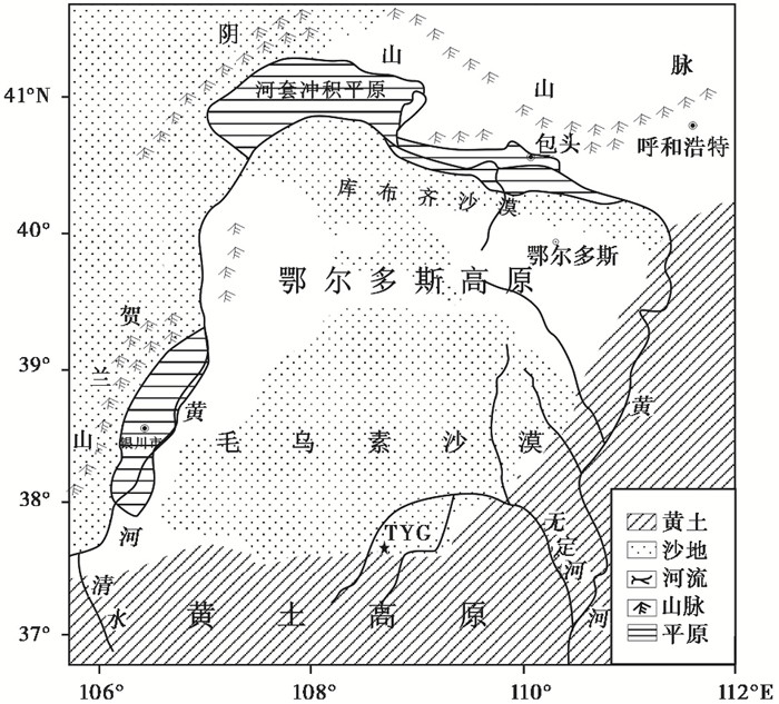
1 研究区概况毛乌素沙漠大部分位于鄂尔多斯东南洼地,属于鄂尔多斯高原向黄土高原的过渡区(图 1)。沙漠内部流动沙丘和固定、半固定沙丘相互交错分布,同时,在低洼处还存在湖盆、滩地和河谷阶地[19]。本区处于我国东部季风边缘区,属于温带干旱、半干旱的大陆性季风气候,年平均降水量400 mm左右,降水具有明显的季风气候特征,主要集中在夏季。冬季盛行西北风,冬春两季风力强劲而频繁,夏季以东南风为主[20]。
|
图 1 研究区和剖面位置图 Fig. 1 Location of the study area and the TYG section |
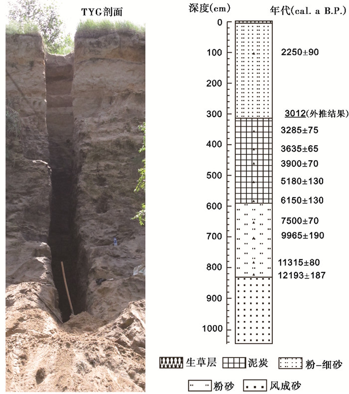
炭窑沟剖面(TYG: 37°43′10.73″N,109°0′4.2″E)位于陕西省靖边县海则滩乡柳树湾村,玄河右岸。剖面厚1050 cm,根据岩性特征将剖面划分为5个地层单元(图 2)。从下至上剖面岩性特征描述如下:
|
图 2 炭窑沟(TYG)剖面照片和岩性柱状图及年代序列 Fig. 2 Photo and lithologic histogram of the TYG section and radiocarbon ages |
1) 1050~834 cm:细砂,灰黄色,上部可见黄色锈斑,未见底;
2) 834~593 cm:粉砂层,黑灰色,较紧实,有黑色夹层;
3) 593~317 cm:泥炭层,黑色,夹有灰黄色和灰褐色条带,紧实,富植物残体,偶见白色霉菌;
4) 317~11 cm:粉-细砂层,浅灰黄色,夹有灰白色、灰绿色和黑灰色粘土条,富黄色锈斑,较疏松,11~64 cm颗粒较细,213 cm以下可见螺壳;
5) 11~0 cm,现代生草层,富现代植物根系。
在剖面每个层位进行样品采集,每隔2 cm或5 cm采集一个常规样品,年代样品采集深度见表 1,共采集常规样品218个,年代样品11个,其中在462~467 cm处有2个年代样品。利用Malvern Mastersizer 2000对常规样品进行粒度测定,测量范围为0.02~2000 μm,在北京师范大学环境演变与自然灾害教育部重点实验室完成。在美国Beta实验室用加速器质谱仪(Accelerator Mass Spectrometry,简称AMS)方法进行样品年代测定,462~467 cm处的2个年代样品分别用全样有机质和植物残体进行测年,其余9个样品测年材料均为全样有机质,年代数据如表 1所示。通过比较发现,年代校正前462~467 cm处两个年代样品的测年误差为80 a(全样有机质测定年龄为3580±30 a B.P.,植物残体测定年龄为3500±30 a B.P.),因此,可以忽略年代数据的“碳库效应”。利用测定的泥炭层年代数据通过线性外延的方法确定泥炭层上界(317 cm)的年龄为3012 cal. a B. P.;另外,由于1050~834 cm缺少测年数据,而且这一层堆积为风成砂,可能会存在沉积不连续或堆积速率不均匀的现象,因此,对于剖面底界年龄只能确定为在12.2 cal.ka B.P.之前,无法确定准确的年龄范围。
| 表 1 炭窑沟剖面AMS 14C年代数据 Table 1 Results of radiocarbon dating of the TYG section |
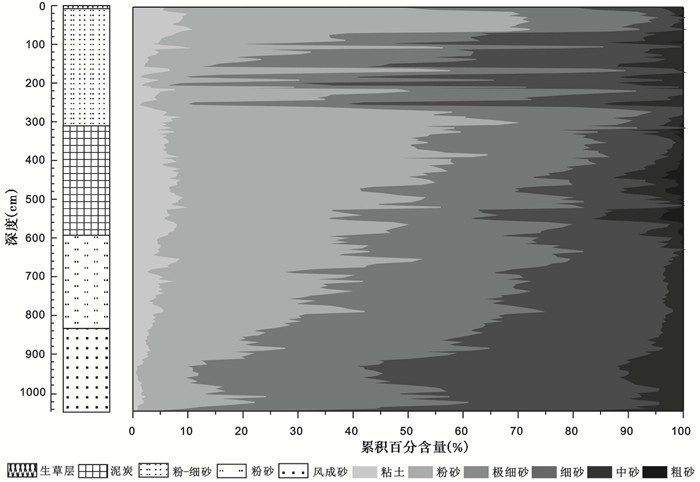
按照吴正等[21]的粒度分级标准,将沉积物粒径分为5个等级:粘土(<4 μm)、粉砂(4~63 μm)、极细砂(63~125 μm)、细砂(125~250 μm)、中砂(250~500 μm)、粗砂(>500 μm)。依照这个标准,对炭窑沟剖面沉积物粒度组成特征进行分析,结果如图 3所示。
|
图 3 炭窑沟剖面粒度组成 Fig. 3 The composition of the grain-size of the TYG section |
从炭窑沟剖面粒度组成图(图 3)可以看出,整个剖面粗砂含量最少,平均值仅为0.5 %,粘土含量次之,粉砂含量最高,平均含量达到32.1 %。对比不同层位沉积物的粒级组成可以看出,各层位之间存在一定差异。0~11 cm的现代生草层以粉砂为主,平均含量高达46.5 %,为整个剖面的最高值。11~317 cm沉积物主要以粉砂和极细砂为主,平均含量分别为34.8 %和30.4 %,与其他层不同,这层沉积物粒度各组分随深度变化波动幅度较大,且比较频繁。317~593 cm的泥炭层以粉砂为主,平均含量为42.8 %,仅次于现代生草层;与上一层相比,泥炭层细颗粒组分(粘土和粉砂)显著增加,粘土含量由5.0 %增加到6.6 %,粉砂含量则由34.5 %增加到42.8 %;同时,这一层中砂和粗砂含量也较其他层高,特别是粗砂含量,为整个剖面的最大值,平均含量为1.5 %。593~834 cm湖相沉积物以极细砂和粉砂为主,平均含量分别为34.7 %和31.1 %,粘土含量比泥炭层偏低,为4.5 %。834~1050 cm的风成砂层以细砂和极细砂为主,细砂含量达到40.7 %,远高于其他各层,而粗砂和细颗粒组分含量则极低,几乎不含粗砂,粘土平均含量仅为1.7 %,粉砂含量为14.6 %。
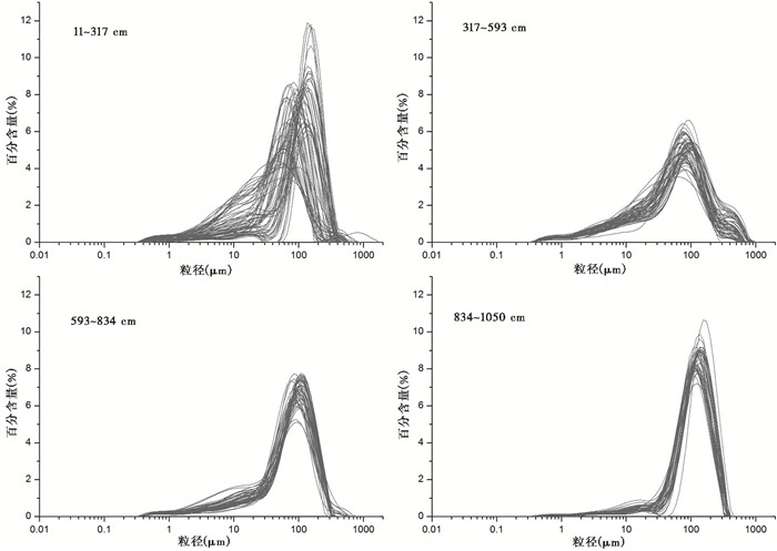
3.2 粒度分布特征沉积物粒度频率分布曲线是判断沉积作用形式的重要方法之一,其峰态变化常反映沉积作用形式的变化[22],因此,我们还分析了不同层位(现代生草层除外)每个样品的粒度频率分布曲线(图 4)。结果表明,11~317 cm沉积物粒度分布曲线表现为两种模式:一种主峰窄且高,说明沉积物分选性较好,众数分布集中,变化范围为110~170 μm,同时,在10~30 μm处还有一个次峰;另一种模式主峰变低变宽,< 63 μm的粉砂和粘土组分显著增多,众数分布范围较广,为40~100 μm。317~593 cm泥炭层粒度分布曲线与其他层位不同,除了在60~120 μm的主峰外,在粗端和细端还各有一个弱峰,粗端的峰粒径集中在300~500 μm,细端的峰比较宽,峰态不明显。593~834 cm沉积物粒度众数分布范围为80~120 μm,在细端的峰与泥炭层类似。834~1050 cm与11~317 cm的一种沉积物粒度分布模式一致,有很好地分选性,主峰集中在110~170 μm,在粉砂粒级还有一个次峰,为典型的风成沉积物分布模式。
|
图 4 炭窑沟剖面不同层位粒度频率分布曲线 Fig. 4 Grain-size distribution at different stratigraphic units of the TYG section |
根据剖面沉积相、年代序列及粒度特征可以将研究区环境演化过程划分为4个时期:
12.2 cal.ka B.P.之前(1050~834 cm)炭窑沟剖面堆积风成砂,沉积物粒度分布曲线与毛乌素沙漠现代风成砂十分一致[23]。风成砂是风作为唯一动力条件堆积的物质,分选性比湖泊沉积物好,粒度分布曲线在110~170 μm和10~30 μm各有一个峰。孙东怀等[24]利用数学方法对风成砂粒度组分进行分离,认为风成砂的这两个峰分别为近源跃移的砂组分和细粒大气背景粉尘组分。12.2 cal.ka B.P.之前风成砂的堆积指示着这一时期气候干旱,炭窑沟地区为沙漠环境。
12.2 cal.ka B.P.之后(834~593 cm)炭窑沟剖面开始堆积湖相沉积,< 63 μm的粉砂和粘土组分显著增多。在干旱半干旱地区,湖泊沉积物除接纳地表径流搬运来的流域物质外,还接受风力输送来的物质[6, 25]。已有的研究认为,湖泊沉积物中> 63 μm[26]或> 100 μm[22, 27]的粗粒物质反映了外源沙尘物质的输入,可以用来记录区域沙尘历史,而细颗粒组分(< 60 μm)则主要由地表径流带入湖泊,反映了流域的降水情况[17, 28]。与毛乌素沙漠地区的红碱淖[6]、岱海[22]和泊江海子[29]等湖泊沉积物相比,12.2~6.2 cal.ka B.P.期间炭窑沟剖面堆积的湖相沉积物细颗粒组分所占比重较小,粒度分布曲线在细颗粒处的峰并不明显。殷志强等[30]分析了多个地点湖泊湖滨、过渡区和湖心3个位置沉积物粒度特征,认为湖滨相70~150 μm组分占优势,而越靠近湖心位置 < 70 μm的细颗粒越多。因此,可以推测12.2~6.2 cal.ka B.P.期间气候变湿,降水增加,炭窑沟地区为湖滨或浅湖环境。
6.2~3.0 cal.ka B.P.(593~317 cm)炭窑沟剖面发育泥炭。泥炭是沼泽、湿地的特有产物,由于地表过湿或薄层积水,大量的植物残体在厌氧环境下不能彻底分解,逐渐累积而泥炭化[31]。因此,泥炭层的出现指示了沉积环境的变化[32~33]。由于沼泽或湿地水动力条件较弱,多沉积悬浮组分,导致泥炭层中粘土和粉砂的含量高达49.4 %。在沼泽或湿地,植被茂密,强风条件下,周边近地面跃移粗粒物质更容易被植被捕获,因此,粒度分布曲线在300~500 μm处出现一个弱峰。王国平等[34]对半干旱区沼泽沉积物粒度特征研究也发现,沼泽沉积剖面粒度有粗化的现象。泥炭层中这一组分记录了短时的大风沙尘暴等强风天气现象,对于其在揭示过去气候变化方面的潜力还需要进一步开展研究。
3.0 cal.ka B.P.之后(317~11 cm)粉-细砂层替代了泥炭。由粒度组成(图 3)和粒度分布曲线(图 4)可以看出,这期间炭窑沟地区沉积环境发生了频繁的变化,其中89~102 cm、138~159 cm、172~213 cm和243~258 cm这几个亚阶段粒度分布曲线与12.2 cal.ka B.P.之前堆积的风成砂一致,沉积物粒度高度分选,说明这些亚阶段炭窑沟地区堆积风成砂,而在其他几个亚阶段沉积物粒度分布曲线与12.2~6.2 cal.ka B.P.的湖相沉积又比较类似,沉积物分选较差,细颗粒组分显著增加,说明这几个亚阶段在炭窑沟地区出现了暂时性积水,沉积物粒度不仅受到风力的作用,还受到流水的影响。总的来说,沉积物粒度的这些变化特征说明3.0 cal.ka B.P.之后毛乌素沙漠东南缘气候变干,但期间也经历了多次干湿变化。
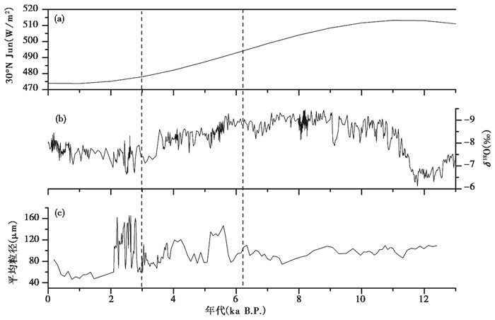
4.2 区域对比毛乌素沙漠作为东亚季风西北边缘区的一部分,其环境变化与周边地区的气候环境变化存在一定的联系。12.2 cal.ka B.P.之后炭窑沟地区由于降水增加,低洼处积水成湖,开始发育湖相沉积。同一时期,在毛乌素沙漠东南缘的萨拉乌苏河[35]和海则滩[36]地区也出露较为典型的河湖相沉积。类似地气候变化模式在周边地区的湖相沉积中也有记录,比如,位于内蒙古高原东南部的湖相沉积记录显示,黄旗海在11.0 ka B.P.开始进入冰后期,气候转暖,湖面回升,植被以云杉属和冷杉属的针叶林为主,林下生长湿生植物,指示了湿润的气候条件[37];内蒙古高原东南部的岱海在12.0~11.0 ka B.P.沉积物孢粉资料显示的高蒿/藜比值,也指示了湿润的气候[38]。全新世早期这种湿润的气候并不稳定,期间经历了多次气候波动。从图 3可以看出,在11.0~10.5 cal.ka B.P.(775~746 cm)和9.1~8.5 cal.ka B.P.(695~677 cm)炭窑沟地区沉积物粒度突然变粗,> 63 μm的粒度组分显著增加,说明这两个时期外源沙尘物质的输入增加[26],出现了干冷气候波动。邻近的内蒙古达里海在11.5~9.8 cal.ka B.P.期间也经历了湖水位的剧烈升降波动[39]。与此同时,在罗布泊[40]、共和盆地[41]、河南老母洞[42]等地区对这次干冷事件也有记录。8.5 cal.ka B.P.前后藏南地区江北剖面和曲水剖面记录了一次明显的风沙活动增强事件[43],这与9.1~8.5 cal.ka B.P.干冷事件在时间上比较吻合。已有研究发现,全新世早期北半球夏季太阳辐射增加[44](图 5a)、东亚季风也随之增强[45](图 5b)以及降水增加,但由于北大西洋融冰造成的淡水爆发,气候发生了多次振荡[46],北大西洋深海沉积记录了11.1 ka、10.3 ka、9.4 ka和8.1 ka的4次冷事件[47],其中11.1 ka和10.3 ka的冷事件与炭窑沟剖面记录的11.0~10.5 cal.ka B.P.气候波动十分一致。Mayewski等[48]分析了全球50个古气候记录,发现在9.0~8.0 cal.ka B.P.存在一次干冷波动,而这次气候波动与炭窑沟地区9.1~8.5 cal.ka B.P.的干冷事件也存在一致性。这些证据都说明炭窑沟剖面记录的这两次气候波动是对全球气候变化过程的响应。
|
图 5 不同古气候记录对比 (a)6月30°N太阳辐射[44];(b)董哥洞石笋δ18O值记录[45];(c)炭窑沟(TYG)剖面平均粒径虚线表示环境演化的不同阶段 Fig. 5 Comparisons with other paleoclimatic records. (a) The monthly average isolation (June) at 30°N[44]; (b)δ18O time series of the Dongge cave stalagmite[45]; (c)The mean grain-size changes recorded by the TYG section. Dash line indicated the boundary of different environmental stages |
6.2~3.0 cal.ka B.P.毛乌素沙漠东南缘降水减少,湖泊水位下降,但此时水热组合条件仍较适宜,植被茂盛,发育泥炭沉积,是气候适宜期。与传统的全新世大暖期(8.5~3.0 ka B.P.)相比[49],本区气候适宜期出现的时间偏晚,但结束的时间较为一致。从泥炭层粒度变化可以看出(图 3),在5.7~5.2 cal.ka B.P.、4.3~3.9 cal.ka B.P.和3.8~3.7 cal.ka B.P.毛乌素沙漠东南缘也出现了气候干冷波动。岱海岩芯记录揭示在约7.9~3.5 ka B.P.岱海流域植被繁盛、生产力相对增强,降水丰富,气候条件也相当适宜[50]。但在一些其他地区中全新世适宜期出现的时间还存在一定的差异:内蒙古察素齐泥炭剖面孢粉数据显示,在5.0~4.1 ka B.P.喜暖湿的阔叶树种大量出现,指示了内蒙古中部地区最适宜的气候条件[51];郭兰兰等[52]通过对鄂尔多斯高原中部巴汗淖湖泊沉积的环境代用指标综合分析发现,鄂尔多斯高原6.2~5.4 ka B.P.温湿组合状况最佳;内蒙古中东部的查干淖尔湖记录了6.9~5.8 cal. ka B.P.和4.5~2.0 cal.ka B.P.两个湿润期[53]。以上这些差异的出现可能与中全新世百年尺度的干冷气候扰动有关,也可能受到区域环境的影响,具体原因还有待进一步研究。
3.0 cal.ka B.P.以后毛乌素沙漠气候恶化,整体表现为变干的趋势,2.1 cal.ka B.P.之前经历了频繁的干湿波动,之后气候趋于平稳。周边的浑善达克沙地自3.2 ka B.P.开始进入温干、冷干的频繁波动期,风沙作用强盛,环境急剧恶化[54]。位于内蒙古高原东南缘的岱海和黄旗海在3.0 ka B.P.以后湖面也急骤收缩,但期间有多次停滞[37]。凌光久等[55]对黄旗海湖相地层的研究也发现,黄旗海流域在3.6~1.6 cal.ka B.P.期间气候环境经历了持续变干的过程。鄂尔多斯高原中部的巴汗淖湖泊在3.7 ka B.P.后也完全干涸[52]。尽管有些沉积序列并没有记录这时期的气候波动,但它们都揭示了晚全新世气候普遍出现变干的趋势。
12.2 cal.ka B.P.以来毛乌素沙漠东南缘虽然经历了多次百年尺度的气候波动,但总体区域环境演化过程可以概括为:12.2 cal.ka B.P.毛乌素沙漠东南缘低洼处开始积水成湖,到6.2 cal.ka B.P.湖泊开始退缩,水位下降,出现沼泽,3.0 cal.ka B.P.以后湖面进一步退缩,湖泊逐渐消失甚至干涸。对比东亚季风演化过程可以发现(图 5),炭窑沟剖面记录的区域环境变化进程与东亚季风盛衰变化具有同步的变化规律。董哥洞石笋δ18O值记录东亚季风在11.5 ka B.P.左右急剧增强,降水增加,而6 ka B.P.以后东亚季风开始减弱,降水减少,在大致3.5 ka B.P.时东亚季风强度又出现较大幅度的减弱[45]。因此,可以认为东亚季风控制了全新世毛乌素沙漠东南缘环境演化的主要进程。
5 结论本文通过分析毛乌素沙漠东南缘炭窑沟剖面沉积物粒度特征,揭示了12.2 cal.ka B.P.以来本区的环境演化过程。12.2 cal.ka B.P.之前,炭窑沟剖面堆积典型风成砂,沉积物粒度以极细砂和细砂为主,细砂含量达到40.7 %,粒度分布曲线表现为双峰型,指示了本区以流沙为主的干旱气候环境。12.2~6.2 cal.ka B.P.炭窑沟地区堆积湖相沉积,沉积物中粉砂和粘土含量增加,粉砂含量由14.6 %增加为31.1 %,而粘土含量则由1.7 %变为4.5 %,说明此时气候变湿,流域降水增加,炭窑沟地区由沙漠环境演化为湖滨或浅湖环境。6.2~3.0 cal.ka B.P.炭窑沟地区发育泥炭,沉积物粒度分布曲线呈三峰型,细颗粒和300~500 μm的粗颗粒含量显著增加,其中粉砂和粘土含量高达49.4 %,揭示本区气候条件进一步好转,由湖滨或浅湖环境转为植被茂密的湿地或沼泽环境。3.0 cal.ka B.P.之后沉积物平均粒径变粗,平均粒径为97.2 μm,随深度变化,粒度各组分波动频繁,而粒度分布曲线表现为两种模式,一种为风成沉积模式,一种为湖相沉积模式,说明本区气候总体变干,但期间还存在几次干湿波动,此时,炭窑沟地区湿地或沼泽消失,在干旱期为裸露的风成砂地表,湿润期有暂时性积水出现。与其他古气候记录对比发现,12.2 cal.ka B.P.以来本区的环境演化过程与季风边缘区气候变化具有很好地一致性,也与东亚季风盛衰变化具有同步的变化规律,说明东亚季风控制了全新世毛乌素沙漠东南缘环境演化的主要进程。
致谢: 感谢赵超、李金凤同学在野外采样工作中的帮助;感谢审稿专家和编辑部杨美芳老师对本文的细心审阅和提出的宝贵修改意见。
| [1] |
成都地质学院陕北队. 沉积岩(物)粒度分析及其应用[M]. 北京: 地质出版社, 1978: 55-66. The Geology Team of Chengdu College of Geology. Sediment Grain Size Analysis and Its Application[M]. Beijing: Geological Publishing House, 1978: 55-66. |
| [2] |
王庆, 王小鲁, 李雪艳, 等. 黄河三角洲南部废弃三角洲潮间滩涂表层沉积粒度特征及其粗化现象[J]. 第四纪研究, 2017, 37(2): 353-367. Wang Qing, Wang Xiaolu, Li Xueyan, et al. Grain size characteristics and coarsening phenomenon of inter-tidal flat surficial sediment along the abandoned southern Yellow River sub-delta[J]. Quaternary Sciences, 2017, 37(2): 353-367. |
| [3] |
殷志强, 秦小光, 吴金水, 等. 中国北方部分地区黄土、沙漠沙、湖泊、河流细粒沉积物粒度多组分分布特征研究[J]. 沉积学报, 2009, 27(2): 343-351. Yin Zhiqiang, Qin Xiaoguang, Wu Jinshui, et al. The multimoda grain-size distribution characteristics of loess, desert, lake and river sediments in some areas of Northern China[J]. Acta Sedmentologica Sinica, 2009, 27(2): 343-351. |
| [4] |
范佳伟, 肖举乐, 温锐林, 等. 达里湖沉积粒度组分-湖面状况定量模型[J]. 第四纪研究, 2016, 36(3): 612-622. Fan Jiawei, Xiao Jule, Wen Ruilin, et al. A model for the linkage between grain-size component in the Dali Lake sediments and lake level status[J]. Quaternary Sciences, 2016, 36(3): 612-622. |
| [5] |
鹿化煜, 安芷生. 黄土高原黄土粒度组成的古气候意义[J]. 中国科学(D辑), 1998, 28(3): 278-283. Lu Huayu, An Zhisheng. Paleoclimatic significance of grainsize of loess-palaeosol depositin Chinese Loess Plateau[J]. Science in China(Series D), 1998, 28(3): 278-283. DOI:10.3321/j.issn:1006-9267.1998.03.002 |
| [6] |
沈吉, 汪勇, 羊向东, 等. 湖泊沉积记录的区域风沙特征及湖泊演化历史:以陕西红碱淖湖泊为例[J]. 科学通报, 2006, 51(1): 87-92. Shen Ji, Wang Yong, Yang Xiangdong, et al. Paleosandstorm characteristic sand lake evolution history deduced from investigation on lacustrine sediments:The case of Hongjiannao Lake, Shaanxi Province[J]. Chinese Science Bulletin, 2006, 51(1): 87-92. DOI:10.3321/j.issn:0023-074X.2006.01.017 |
| [7] |
聂军胜, 李曼. 柴达木盆地晚中新世河湖相沉积物粒度组成及其古环境意义[J]. 第四纪研究, 2017, 37(5): 1017-1026. Nie Junsheng, Li Man. A grain size study on Late Miocene Huaitoutala section, NE Qaidam Basin, and its implications for Asian monsoon evolution[J]. Quaternary Sciences, 2017, 37(5): 1017-1026. |
| [8] |
刘世昊, 丰爱平, 李培英, 等. 现代黄河三角洲地区晚更新世以来高分辨率沉积粒度特征及动力沉积环境演化[J]. 第四纪研究, 2015, 35(2): 291-306. Liu Shihao, Feng Aiping, Li Peiying, et al. High-resolution grain size distribution and evolution of the sediment-dynamic environment in the modern Yellow River delta since the Latest Pleistocene[J]. Quaternary Sciences, 2015, 35(2): 291-306. |
| [9] |
向荣, 杨作升, Saito Y, 等. 济州岛西南泥质区近2300 a来环境敏感粒度组分记录的东亚冬季风变化[J]. 中国科学(D辑), 2006, 49(7): 654-662. Xiang Rong, Yang Zuosheng, Saito Y, et al. East Asia winter monsoon changes inferred from environmentally sensitive grain size component records during the last 2300 a in mud area southwest of Cheju Island, ECS[J]. Science in China(Series D), 2006, 49(6): 604-614. |
| [10] |
姜韬, 曾志刚, 南青云, 等. 全新世以来冲绳海槽北部S9孔粒度变化特征及其古气候响应[J]. 第四纪研究, 2015, 35(2): 307-318. Jiang Tao, Zeng Zhigang, Nan Qingyun, et al. The grain size characteristic of the core S9 sediments in the northern Okinawa Trough and their paleoclimate response since Holocene[J]. Quaternary Sciences, 2015, 35(2): 307-318. |
| [11] |
孙东怀, 鹿化煜, Rea D K, 等. 中国黄土粒度的双峰分布及其古气候意义[J]. 沉积学报, 2000, 18(3): 327-335. Sun Donghuai, Lu Huayu, Rea D K, et al. Bimode grain-size distribution of Chinese loess and its paleoclimate implication[J]. Acta Sedimentologica Sinica, 2000, 18(3): 327-335. DOI:10.3969/j.issn.1000-0550.2000.03.001 |
| [12] |
Sly P G. Sedimentary processes in lakes[M]//Lerman A. Lakes: Chemistry, Geology, Physics. New York: Springer-Verlag, 1978: 65-90.
|
| [13] |
陈敬安, 万国江, 张峰, 等. 不同时间尺度下的湖泊沉积物环境记录——以沉积物粒度为例[J]. 中国科学(D辑), 2004, 47(6): 563-568. Chen Jing'an, Wan Guojiang, Zhang Feng, et al. Environment records of lacustrine sediments in different time scale:Sediment grain size as an example[J]. Science in China(Series D), 2004, 47(10): 954-960. |
| [14] |
Long Hao, Lai Zhongping, Wang Nai'ang, et al. Holocene climate variations from Zhuyeze terminal lake records in East Asian monsoon margin in arid Northern China[J]. Quaternary Research, 2010, 74(1): 46-56. DOI:10.1016/j.yqres.2010.03.009 |
| [15] |
刘兴起, 姚波, 杨波. 青藏高原北部可可西里库赛湖沉积物及风成物的粒度特征[J]. 第四纪研究, 2010, 30(6): 1193-1198. Liu Xingqi, Yao Bo, Yang Bo. Grain size distribution of aeolian and lacustrine sediments of Kusai Lake in the Hoh Xil region of the northern Qinghai-Tibetan Plateau[J]. Quaternary Sciences, 2010, 30(6): 1193-1198. DOI:10.3969/j.issn.1001-7410.2010.06.17 |
| [16] |
郭超, 马玉贞, 刘杰瑞, 等. 过去2000年来西藏羊卓雍错沉积物粒度记录的气候变化[J]. 第四纪研究, 2016, 36(2): 405-419. Guo Chao, Ma Yuzhen, Liu Jierui, et al. Climatic change recorded by grain size in the past about 2000 years from Yamzhog Yumco Lake, Tibet[J]. Quaternary Sciences, 2016, 36(2): 405-419. |
| [17] |
肖舜, 陈发虎, 强明瑞, 等. 青海苏干湖表层沉积物粒度分布模式与大气粉尘记录[J]. 地理学报, 2007, 62(11): 1153-1164. Xiao Shun, Chen Fahu, Qiang Mingrui, et al. Distribution pattern of grain size in surface sediments from Sugan Lake and its potential in recording aeolian dust in arid China[J]. Acta Geographica Sinica, 2007, 62(11): 1153-1164. |
| [18] |
郭晓阳, 王维, 王国良, 等. 季风边缘区湖泊表层沉积物粒度组分分布特征与影响因素[J]. 地理研究, 2016, 35(4): 677-691. Guo Xiaoyang, Wang Wei, Wang Guoliang, et al. Within-lake distributions of grain-size components and environmental implications based on the survey of lake surface sediment of Chinese monsoon marginal area[J]. Geographical Research, 2016, 35(4): 677-691. |
| [19] |
朱震达, 吴正, 刘恕, 等. 中国沙漠概论[M]. 北京: 科学出版社, 1980: 68-73. Zhu Zhenda, Wu Zheng, Liu Shu, et al. Introduction to the Desert of China[M]. Beijing: Science Press, 1980: 68-73. |
| [20] |
孙继敏, 刘东生, 丁仲礼, 等. 五十万年来毛乌素沙漠的变迁[J]. 第四纪研究, 1996(4): 359-367. Sun Jimin, Liu Tungsheng, Ding Zhongli, et al. The Mu Us Desert evolution in the last 0.5 Ma[J]. Quaternary Sciences, 1996(4): 359-367. DOI:10.3321/j.issn:1001-7410.1996.04.009 |
| [21] |
吴正, 等. 风沙地貌与治沙工程学[M]. 北京: 科学出版社, 2010: 196-200. Wu Zheng, et al. Geomorphology of Wind-drift Sands and Their Controlled Engineering[M]. Beijing: Science Press, 2010: 196-200. |
| [22] |
孙千里, 周杰, 肖举乐. 岱海沉积物粒度特征及其古环境意义[J]. 海洋地质与第四纪地质, 2001, 21(1): 93-95. Sun Qianli, Zhou Jie, Xia Jule. Grain-size characteristics of Lake Daihai sediments and its paleoenvironment significance[J]. Marine Geology & Quaternary Geology, 2001, 21(1): 93-95. |
| [23] |
舒培仙, 李保生, 牛东风, 等. 毛乌素沙漠东南缘滴哨沟湾剖面DGS1层段粒度特征及其指示的全新世气候变化[J]. 地理科学, 2016, 36(3): 448-457. Shu Peixian, Li Baosheng, Niu Dongfeng, et al. Climate variations recorded by the grain-size from the DGS1 segment in the southeast of China's Mu Us Desert during the Holocene[J]. Scientia Geographica Sinica, 2016, 36(3): 448-457. |
| [24] |
孙东怀, 安芷生, 苏瑞侠, 等. 古环境中沉积物粒度组分分离的数学方法及其应用[J]. 自然科学进展, 2001, 11(3): 269-276. Sun Donghuai, An Zhisheng, Su Ruixia, et al. The mathematical method and it's application of partition grain-size distribution from these dimentary components in paleoenvironments[J]. Progress of Natural Sciences, 2001, 11(3): 269-276. DOI:10.3321/j.issn:1002-008X.2001.03.008 |
| [25] |
Chen Chen-Tung A, Lan Hsin-Chi, Lou Jiann-Yuh, et al. The dry Holocene Megathermal in Inner Mongolia[J]. Palaeogeography, Palaeoclimatology, Palaeoecology, 2003, 193(2): 181-200. DOI:10.1016/S0031-0182(03)00225-6 |
| [26] |
强明瑞, 陈发虎, 周爱锋, 等. 苏干湖沉积物粒度组成记录尘暴事件的初步研究[J]. 第四纪研究, 2006, 26(6): 915-922. Qiang Mingrui, Chen Fahu, Zhou Aifeng, et al. Preliminary study on dust storm events documented by grain size components of Sugan Lake sediments, north Qaidam Basin[J]. Quaternary Sciences, 2006, 26(6): 915-922. DOI:10.3321/j.issn:1001-7410.2006.06.005 |
| [27] |
金章东, 王苏民, 沈吉, 等. 岱海地区近400年来的"尘暴"事件——来自岱海沉积物粒度的证据[J]. 湖泊科学, 2000, 12(3): 193-198. Jin Zhangdong, Wang Sumin, Shen Ji, et al. Dust-storm events in Daihai Lake area, Inner Mongolia during the past 400 years:Evidence from grain size analysis of lake sediments[J]. Journal of Lake Sciences, 2000, 12(3): 193-198. DOI:10.3321/j.issn:1003-5427.2000.03.001 |
| [28] |
隆浩, 王乃昂, 李育, 等. 毛乌素沙漠北缘泊江海子剖面粒度特征及环境意义[J]. 中国沙漠, 2007, 27(2): 187-193. Long Hao, Wang Nai'ang, Li Yu, et al. Particle size characteristics of deposits from PJHZ section in Northern edge of Mu Us Desert and their environmental significance[J]. Journal of Desert Research, 2007, 27(2): 187-193. DOI:10.3321/j.issn:1000-694X.2007.02.004 |
| [29] |
隆浩, 王乃昂, 马海州, 等. 腾格里沙漠西北缘湖泊沉积记录的区域风沙特征[J]. 沉积学报, 2007, 25(4): 626-631. Long Hao, Wang Nai'ang, Ma Haizhou, et al. Eolian activity and environment evolution history recorded by the Qingtu Lake, NW Tengger Desert[J]. Acta Sedmentologica Sinica, 2007, 25(4): 626-631. DOI:10.3969/j.issn.1000-0550.2007.04.018 |
| [30] |
殷志强, 秦小光, 吴金水, 等. 湖泊沉积物粒度多组分特征及其成因机制研究[J]. 第四纪研究, 2008, 28(2): 345-353. Yin Zhiqiang, Qin Xiaoguang, Wu Jinshui, et al. Multimodal grain-size distribution characteristics and formation mechanism of lake sediments[J]. Quaternary Sciences, 2008, 28(2): 345-353. DOI:10.3321/j.issn:1001-7410.2008.02.018 |
| [31] |
张兰芳, 苗美玲, 郭伊乐. 鄂尔多斯泥炭资源的开发与利用初探[J]. 内蒙古草业, 2005, 17(3): 14-15. Zhang Lanfang, Miao Meiling, Guo Yile. Exploration and utilization of peat resources in Ordos[J]. Inner Mongolia Prataculture, 2005, 17(3): 14-15. DOI:10.3969/j.issn.2095-5952.2005.03.005 |
| [32] |
王庆锋, 金会军, 吴青柏, 等. 距今约6000年以来青藏高原东北部黄河源区冻结泥炭沉积记录的气候演化[J]. 第四纪研究, 2017, 37(2): 402-415. Wang Qingfeng, Jin Huijun, Wu Qingbai, et al. Climatic evolution since 6 cal.ka B.P. recorded by frozen peat deposits in the source area of the Yellow River, northeastern Qinghai-Tibet Plateau[J]. Quaternary Sciences, 2017, 37(2): 402-415. |
| [33] |
牛蕊, 周立旻, 孟庆浩, 等. 贵州草海南屯泥炭记录的中全新世以来的气候变化[J]. 第四纪研究, 2017, 37(6): 1357-1369. Niu Rui, Zhou Limin, Meng Qinghao, et al. The paleoclimate variations of the Nantun peat in the Caohai area since the Middle Holocene[J]. Quaternary Sciences, 2017, 37(6): 1357-1369. |
| [34] |
王国平, 刘景双, 汤洁. 半干旱区沼泽沉积物粒度特征及环境意义[J]. 干旱区研究, 2003, 20(3): 211-216. Wang Guoping, Liu Jingshuang, Yang Jie. Characteristics and environmental significance of the granularity of swampy sediment in semi-arid areas[J]. Arid Zone Research, 2003, 20(3): 211-216. |
| [35] |
Liu Kai, Lai Zhongping. Chronology of Holocene sediments from the archaeological Salawusu site in the Mu Us Desert in China and its palaeoenvironmental implications[J]. Journal of Asian Earth Sciences, 2012, 45: 247-255. DOI:10.1016/j.jseaes.2011.11.002 |
| [36] |
苏志珠, 董光荣, 李小强, 等. 晚冰期以来毛乌素沙漠环境特征的湖沼相沉积记录[J]. 中国沙漠, 1999, 19(2): 104-109. Su Zhizhu, Dong Guangrong, Li Xiaoqiang, et al. The lake-swamp sediment records on the environmental characteristics of Mu Us Desert since the late glacial epoch[J]. Journal of Desert Research, 1999, 19(2): 104-109. |
| [37] |
李华章, 刘清泗, 汪家兴. 内蒙古高原黄旗海、岱海全新世湖泊演变研究[J]. 湖泊科学, 1992, 4(1): 31-39. Li Huazhang, Liu Qingsi, Wang Jiaxing. Study of evolution of Huangqihai and Daihai lakes in Holocene in Inner Mongolia Plateau[J]. Journal of Lake Sciences, 1992, 4(1): 31-39. |
| [38] |
许清海, 肖举乐, 中村俊夫, 等. 孢粉资料定量重建全新世以来岱海盆地的古气候[J]. 海洋地质与第四纪地质, 2003, 23(4): 99-108. Xu Qinghai, Xiao Jule, Nakamura Toshio, et al. Quantitative reconstructed climatic changes of Daihai basin by pollen data[J]. Marine Geology & Quaternary Geology, 2003, 23(4): 99-108. |
| [39] |
Xiao Jule, Chang Zhigang, Si Bin, et al. Partitioning of the grain-size components of Dali Lake core sediments:Evidence for lake level changes during the Holocene[J]. Journal of Paleolimnology, 2009, 42(2): 249-260. DOI:10.1007/s10933-008-9274-7 |
| [40] |
贾红娟, 汪敬忠, 秦小光, 等. 罗布泊地区晚冰期至中全新世气候特征及气候波动事件[J]. 第四纪研究, 2017, 37(3): 510-521. Jia Hongjuan, Wang Jingzhong, Qin Xiaoguang, et al. Climate and abrupt events recorded in the Lop Nur region from late glacial to the Middle Holocene[J]. Quaternary Sciences, 2017, 37(3): 510-521. |
| [41] |
刘冰, 靳鹤龄, 孙忠, 等. 青藏高原东北部泥炭沉积粒度与元素记录的全新世千年尺度的气候变化[J]. 冰川冻土, 2013, 35(3): 609-620. Liu Bing, Jin Heling, Sun Zhong, et al. Holocene millennial-scale climate change recorded by grain size and chemical elements of peat deposits in Gonghe Basin, northeastern Tibetan Plateau[J]. Journal of Glaciology and Geocryology, 2013, 35(3): 609-620. |
| [42] |
张银环, 杨琰, 杨勋林, 等. 早全新世季风演化的高分辨率石笋δ18O记录研究——以河南老母洞石笋为例[J]. 沉积学报, 2015, 33(1): 134-141. Zhang Yinhuan, Yang Yan, Yang Xunlin, et al. Early Holocene monsoon evolution of high resolution stalagmite δ18O records:In Henan Laomu cave[J]. Acta Sedmentologica Sinica, 2015, 33(1): 134-141. |
| [43] |
刘星星, 宋磊, 金彦香, 等. 青藏高原全新世风沙活动历史与环境变化[J]. 干旱区资源与环境, 2013, 27(6): 41-47. Liu Xingxing, Song Lei, Jin Yanxiang, et al. History of aeolian deposits in Tibetan Plateau and climate change over Holocene[J]. Journal of Arid Land Resources and Environment, 2013, 27(6): 41-47. |
| [44] |
Berger A, Loutre M F. Insolation values for the climate of the last 10 million years[J]. Quaternary Science Reviews, 1991, 10: 297-317. DOI:10.1016/0277-3791(91)90033-Q |
| [45] |
Dykoski Carolyn A, Edwards R Lawrence, Cheng Hai, et al. A high-resolution, absolute-dated Holocene and deglacial Asian monsoon record from Dongge cave, China[J]. Earth and Planetary Science Letters, 2005, 233(1-2): 71-86. DOI:10.1016/j.epsl.2005.01.036 |
| [46] |
王绍武. 全新世气候变化[M]. 北京: 气象出版社, 2011: 106-120. Wang Shaowu. The Holocene Climate Change[M]. Beijing: China Meteorological Press, 2011: 106-120. |
| [47] |
Bond Gerard, Showers William, Cheseby Maziet, et al. A pervasive millennial-scale cycle in North Atlantic Holocene and glacial climates[J]. Science, 1997, 278(5341): 1257-1266. DOI:10.1126/science.278.5341.1257 |
| [48] |
Mayewski P A, Rohling E E, Stager J C, et al. Holocene climate variability[J]. Quaternary Research, 2004, 62: 243-255. DOI:10.1016/j.yqres.2004.07.001 |
| [49] |
施雅风, 孔昭宸, 王苏民, 等. 中国全新世大暖期的气候波动与重要事件[J]. 中国科学(B辑), 1992, 22(12): 1300-1308. Shi Yafeng, Kong Zhaochen, Wang Sumin, et al. The climatic fluctuations and important events of Holocene Megathermal in China[J]. Science in China(Series B), 1992, 22(12): 1300-1308. |
| [50] |
孙千里, 肖举乐. 岱海沉积记录的季风/干旱过渡区全新世适宜期特征[J]. 第四纪研究, 2006, 26(5): 781-790. Sun Qianli, Xiao Jule. Characteristics of the Holocene Optimum in the monsoon/arid transition belt recorded by core sediments of Daihai Lake, North China[J]. Quaternary Sciences, 2006, 26(5): 781-790. DOI:10.3321/j.issn:1001-7410.2006.05.013 |
| [51] |
王琫瑜, 孙湘君. 内蒙古察素齐泥炭剖面全新世古环境变迁的初步研究[J]. 科学通报, 1997, 42(5): 274-278. Wang Bengyu, Sun Xiangjun. A preliminary study on the palaeoenvironmental changes recorded by the Chasuqi deposition section during the Holocene in Inner Mongolia[J]. Chinese Science Bulletin, 1997, 42(5): 274-278. |
| [52] |
郭兰兰, 冯兆东, 李心清, 等. 鄂尔多斯高原巴汗淖湖泊记录的全新世气候变化[J]. 科学通报, 2007, 52(5): 584-590. Guo Lanlan, Feng Zaodong, Li Xinqing, et al. Holocene climatic and environmental changes recorded in Baahar Nuur Lake core in the Ordos Plateau, Inner Mongolia of China[J]. Chinese Science Bulletin, 2007, 52(5): 584-590. DOI:10.3321/j.issn:0023-074X.2007.05.015 |
| [53] |
韩鹏, 刘兴起. 内蒙古中东部查干淖尔湖流域7000年以来的气候演变[J]. 第四纪研究, 2017, 37(6): 1381-1390. Han Peng, Liu Xingqi. The climate evolution inferred from Chagan-Nuur in middle-east part of Inner Mongolia since the last 7000 years[J]. Quaternary Sciences, 2017, 37(6): 1381-1390. |
| [54] |
李森, 孙武, 李孝泽, 等. 浑善达克沙地全新世沉积特征与环境演变[J]. 中国沙漠, 1995, 15(4): 323-331. Li Sen, Sun Wu, Li Xiaoze, et al. Sedimentary characteristics and environmental evolution of Otindag sandy land in Holocene[J]. Journal of Desert Research, 1995, 15(4): 323-331. DOI:10.3321/j.issn:1000-694X.1995.04.011 |
| [55] |
凌光久, 贾玉连, 马春梅, 等. 内蒙古黄旗海中晚全新世(3580-1630 cal. a B.P.)气候环境记录[J]. 第四纪研究, 2016, 36(2): 257-267. Ling Guangjiu, Jia Yulian, Ma Chunmei, et al. Mid-Late Holocene(3580-1630 cal. a B.P.)climate and environment records from Huangqihai Lake in Inner Mongolia[J]. Quaternary Sciences, 2016, 36(2): 257-267. |
2 State Key Laboratory of Earth Surface Processes and Resource Ecology, Faculty of Geographical Science, Beijing Normal University, Beijing 100875;
3 Engineering Center of Desertification and Blown-Sand Control of Ministry of Education, Faculty of Geographical Science, Beijing Normal University, Beijing 100875;
4 Key Laboratory of Environmental Change and Natural Disaster of Ministry of Education, Faculty of Geographical Science, Beijing Normal University, Beijing 100875)
Abstract
The Mu Us Desert, located in the desert/loess transition zone and in the margin of the East Asian summer monsoon, is an ideal region for studying past environmental changes due to its sensitive climatic response. Fluvial-lacustrine sediments, peat and aeolian deposits have been used to explore past climate changes in this area. Compared to aeolian deposits, fluvial-lacustrine sediments and peat provide high resolution climatic or environmental information because of the relatively uniform accumulation rate in an aquatic or wetland environment. In this paper, we obtained a 1050 cm-long lacustrine-peat sediment sequence(TYG section:37°43'10.73"N, 109°0'4.2"E) from the southeastern margin of Mu Us Desert. This section located on the first terrace of the Xuanhe River, a third-order tributary of the Yellow River. Subsamples were taken generally at an interval of 2 cm or 5 cm, and a total of 218 samples were collected for grain-size analysis using Malvern Mastersizer 2000. 11 samples were collected from the TYG section for Accelerator Mass Spectrometry(AMS) 14C dating at the Beta Analytic Radiocarbon Dating Laboratory. The dating results indicated the aeolian sand at 1050~834 cm accumulated before 12.2 cal.ka B.P., lacustrine sediments at 834~593 cm deposited from 12.2 cal.ka B.P. to 6.2 cal.ka B.P., peat at 593~317 cm developed from 6.2 cal.ka B.P. to 3.0 cal.ka B.P., and silt-sand at 317~11 cm accumulated after 3.0 cal.ka B.P. We reconstructed regional environment changes since 12.2 cal.ka B.P. based on the grain-size characteristic of a high-resolution Holocene sequence of lacustrine-peat sediments. Our results indicate that before 12.2 cal.ka B.P., sediments sizes of TYG section were coarser than other periods, and main fractions of grain size were fine sand and sand, with the content of fine sand was 40.7%, distribution curve of grain size was bimodal. These results indicated climate was dry and this region was in a desert environment before 12.2 cal.ka B.P. From 12.2 cal.ka B.P. to 6.2 cal.ka B.P., lacustrine sediments occurred in the TYG section, accompanying with decreased sand fraction and increased fine grain-size fraction. The content of silt increased from 14.6% to 31.1%, and the content of clay changed from 1.7% to 4.5%.These evidences indicated that climate was wet and desert environment turned to shallow lake. Peat replaced lacustrine sediments in TYG section between 6.2 cal.ka B.P. and 3.0 cal.ka B.P. Clay and silt fraction content increased to 49.4%. The distribution curve of grain size was multimodal and there was a weak peak at 300~500 μm because coarse grains were more easily captured by the plants. These suggested that climate was optimum and shallow lake changed to swamp during this period in this region. Silt-sand accumulated and grain-size of sediments has two different distribution patterns since 3.0 cal.ka B.P. One was similar with that of aeolian sand, and the other was similar with that of lacustrine sediments. These evidences implied that climate turned to dry but it fluctuated frequently with several wet fluctuations since 3.0 cal.ka B.P. Comparison with other lacustrine sediments from surrounding areas shown that the environmental evolution in the southeastern margin of Mu Us Desert since 12.2 cal.ka B.P. was consistent with the climate changes in the margin of the East Asian summer monsoon, and was also synchronous with the changes of East Asian monsoon, indicating that the environmental evolution in the southeastern margin of Mu Us Desert was controlled by East Asian monsoon. 2018, Vol.38
