2 中国科学院西北生态环境资源研究院, 甘肃 兰州 730000;
3 云南大学资源环境与地球科学学院, 云南 昆明 650504;
4 中国科学院青藏高原研究所, 北京 100101)
过去15万年,地球经历的最近一次完整的冰期-间冰期旋回,是研究地球气候环境系统变化规律的重要时段[1~4]。深海氧同位素记录提供了轨道尺度上的环境变化时间序列[5~6],极地冰芯记录(如:Dome C和NGRIP)重建了末次间冰期以来的温度演化历史[7~8]。这些研究使我们对全球范围的过去15万年来的古气候演化有了基本的认识。经过许多科学家的努力,黄土[9~11]、石笋[12~25]、湖泊[26~30]、沙漠[31~33]也为过去气候环境变化提供了重要信息。在我国,经过长期的研究,对季风气候的演化历史及其形成机制已经有了较为清晰的认识,但西风影响区的研究仍需更多的深入探索。
我国西北干旱区是亚欧大陆中部干旱区的重要组成部分,该区域受北半球中纬度西风环流的显著影响,相对于亚洲大陆东南部的季风区而言,可简称为西风区。现代气候条件下,西风区与季风区在我国的分界大致是:沿大兴安岭向西南延伸,经河套地区至青藏高原东北部边缘,然后过青海湖西北部,经高原中部32°N一线西伸至国境线[34],与我国干旱-半干旱区的界限大体重合,符合我国气候-生物带实际分布情况,有明确的气候和环境意义。界限以西和以北的西风区,分布大面积的沙漠和(高寒)荒漠[35],生态系统脆弱,对气候变化响应敏感,全球变化影响显著。
我国学者很早就注意到西风区气候环境变化的特殊性[36],随着近年来代用记录的开发和积累[37~42],通过集成研究进一步发现,在现代间冰期(全新世)不同时间尺度上,西风区气候变化与季风区有显著差异,其湿度变化在全新世与亚洲季风演化历史存在“错位相”关系[34];近千年来,两者关系甚至表现出“反位相”特征[43]。在年代际尺度上,全球变暖背景下,内陆干旱区普遍出现山地降水和出山径流增加,封闭湖泊面积扩大,自然绿洲区域扩张等现象,指示了区域气候发生转型[44],这与我国华北地区季风衰退、气候干旱化[45]形成鲜明对照。据此,陈发虎等[46]首先提出在现代间冰期(全新世)存在气候变化的“西风模态”,实际上是万年以下的非轨道尺度上全球变化在不同气候区域不同响应方式的体现。那么在末次冰期/间冰期轨道尺度上,我国西北干旱区气候环境变化的具体表现如何?在末次冰期内部备受关注的深海氧同位素第3阶段(MIS 3)、末次冰期最盛期(Last Glacial Maximum,简称LGM)等特殊时段,我国西风区气候环境变化有着哪些区域特点?对于这些重要科学问题,还没有明确的答案。
新疆是我国西北干旱区的重要组成部分,也是典型的西风影响区域[47]。对这一区域湖泊记录的研究,有助于深入理解前文提到的这些关键科学问题。但该区域长序列的气候记录有限,仅有的记录显示,关于这个区域末次间冰期以来气候变化特征的说法并不一致[36, 48~57]。比如,关于末次冰盛期是否存在高湖面的争论。导致目前认识存在分歧的最主要的原因是,已有的湖泊记录往往只包含了过去15万年来的一个或几个片段[58~61],难以窥其全貌。现有的长序列的湖泊记录,受限于测年的不确定性、较低分辨率[62~64]以及地层缺失[54, 65]等,而不能提供准确、完整的高分辨率的气候环境演化信息。因此,重建区域末次间冰期以来湖泊记录的气候环境演化序列,关键是建立年代可靠、序列完整的气候记录。为此我们选择了新疆研究基础较好的乌伦古湖、博斯腾湖和巴里坤湖为研究对象,并分别获取长钻岩芯,进行相关的研究。
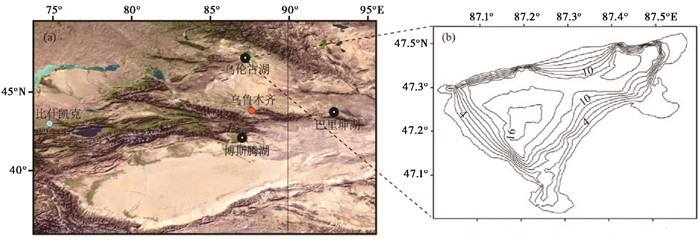
1 材料与方法 1.1 样品采集乌伦古湖位于新疆北部阿勒泰地区福海县(图 1a),是乌伦古河的尾闾封闭湖泊。湖形似三角形,南北宽约30 km,东西长35 km,湖水面积为859 km2。于2010年实地测量结果表明,该湖泊最大水深为18 m(图 1b);同期在乌伦古湖湖岸附近利用手工钻钻取了长3.56 m的岩芯WLG10B(47°21′N,87°27′E),相关成果已经发表[66]。于2011年2月利用X-1型100 m机械钻从湖心钻取长24.11 m的湖泊岩芯,命名为WLG11E(47°14.4′N,87°13.1′E;海拔479 m)。本文对WLG11E岩芯0~9 m部分进行研究(表 1),湖泊沉积物主要由粉砂质粘土、粉砂等组成,以5 cm间隔进行粒度实验分析。

|
图 1 研究点(a)及乌伦古湖实际水深分布(m) (b) Fig. 1 Study sites (a) and the depth contour (m)of Wulugu Lake (b) |
| 表 1 3个岩芯的相关参数信息 Table 1 Related parameter information of three sediment cores |
博斯腾湖位于新疆博湖县,是以开都河补给为主的开放性湖泊。湖泊东西长55 km,南北宽25 km,水域总面积超过800 km2。于2010年实地测量结果显示,该湖平均深度10 m,最大水深超过15 m。2011年冬天利用X-1型100 m机械钻从湖心钻取了长51.6 m的湖泊岩芯,命名为BST12B(42°0.7′N,87°9.3′E;海拔1051 m)。本文主要研究BST12B岩芯顶部20 m部分(表 1),湖泊沉积物主要由粉砂质粘土、砂、黄土质粘土和粘土组成。以2~3 cm间隔完成粒度实验分析。
巴里坤湖(43°36′~43°45′N,92°42′~92°54′E;海拔1575 m)位于新疆巴里坤县。湖泊形状略呈椭圆形,东西宽约9 km,南北长13 km,湖泊面积约116 km2。该湖主要补给源来自巴里坤山和莫钦乌拉山,以地表径流和地下水的形式补给。湖泊盐度较高。我们于2005年考察时了解到湖泊的水深普遍在0.5~1.0 m。并于2011年利用X-1型100 m机械钻从湖心钻取了长62.53 m的湖泊岩芯,命名为BLK11A。本文主要分析了BLK11A岩芯顶部45 m部分(表 1),湖泊沉积物主要由粘土、砂和盐层组成,以1 cm间隔进行粒度实验分析。
所有岩芯样品密封在湖泊岩芯专用PVC管中,用黑色塑料布包裹后装箱运回实验室,于4 ℃下保存在冷冻箱内,之后进行分样。在分样前,首先选取释光测年样品,该样品的采集需要在柔和的红光下利用核心管收集,并储存在恒温为4 ℃冷库中;然后详细描述钻孔岩性特征并分样,其间选取出14C测年的样品;最后对分好的样品进行各代用指标的实验分析。本文主要报告这3个湖泊岩芯末次间冰期以来年代、岩性和粒度的变化特征。
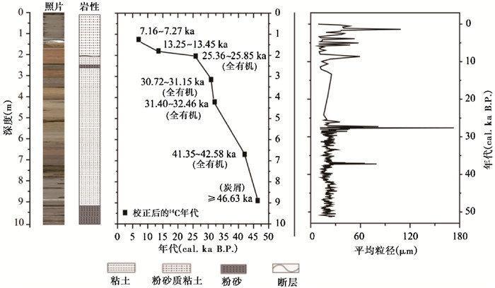
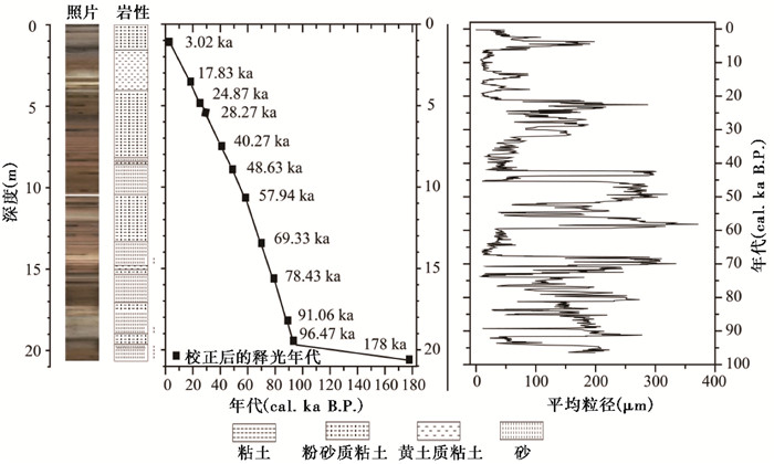
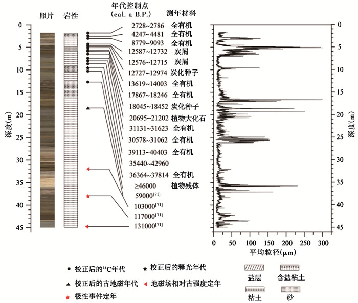
1.2 测年方法年代测定主要采用了加速器AMS 14C和光释光测年方法。其中WLG11E岩芯采用AMS 14C测年方法,测年材料包括全有机和炭屑,测得7个年代数据,其中120 cm和159 cm的年代样在北京大学测试,其余5个14C年代样在美国Beta实验室测试并已发表[67]。扣除760 a的碳库效应[72]后进行年代校正,之后线性内插获得WLG11E岩芯9 m以上的年代-深度模型(图 2)。BST12B岩芯采用石英和钾长石光释光测年方法,利用Risø TL/OSL-20释光测量系统完成,获取12个年代数据[68]。通过线性内插建立了BST12B岩芯20 m以上的年代框架(图 3)。BLK11A岩芯主要采用AMS 14C测年、光释光测年技术,并结合已有的古地磁研究结果,建立了岩芯顶部45 m可靠的年代标尺。其中15个14C年代样在美国Beta实验室完成,测年材料包括全有机、炭屑等;1个光释光年代样,在兰州大学西部环境教育部重点实验室完成;其余的4个年代结果已经发表[71],扣除790 a的碳库效应[56, 69]后进行年代校正,线性内插得到了BLK11A岩芯的年代-深度模型,如图 4显示。

|
图 2 乌伦古湖WLG11E岩芯地层、年代及平均粒径变化(年代数据多引自Zhang等[67]) Fig. 2 The stratum-depth-age and variation of grain size of the core WLG11E from Wulugu Lake(data from Zhang, et al. [67]) |

|
图 3 博斯腾湖BST12B地层、年代及平均粒径变化(年代数据引自Li等[68]) Fig. 3 The stratum-depth-age and variation of grain size of the core BST 12B from Bosten Lake(data from Li, et al. [68]) |

|
图 4 巴里坤湖BLK11A地层、年代数据及平均粒径变化 AMS 14C和OSL年代引自文献[56, 69~70];古地磁数据引自刘宇航[71] Fig. 4 The stratum-depth-age and variation of grain size of the core BLK11A from Balikun Lake. AMS 14C and OSL dates derived from references[56, 69~70]; Palaeomagnetism data derived from Liu[71] |
湖泊岩芯的粒度实验分析采用Peng等[73]方法,使用Malvern Mastersizer 2000型激光粒度仪进行测量,该仪器测量范围在0.02~2000 μm,测量误差小于0.2 %;同时也分析完整沉积岩芯的岩石磁学特征,获得了地磁场相对强度[71]。指标分析在兰州大学西部环境教育部重点实验室完成。
2 初步结果 2.1 乌伦古湖乌伦古湖WLG11E岩芯在8.98 m处的14C年代大于46.63 cal.ka B.P.[67]。因此,9 m以上的岩芯记录了近50 ka来的气候环境变化(图 2)。
就岩性特征来说,9.0~6.2 m(46.6~40.0 cal.ka B.P.)为灰色粉砂质粘土,粒度偏细,平均粒径为20.8 μm,属于较为典型的湖泊沉积;6.2~2.7 m(40.0~28.9 cal.ka B.P.)为黄色粉砂质粘土,平均粒径为21.2 μm,比前一个时期略大,并且在39.0 cal.ka B.P.和28.9 cal.ka B.P.前后出现平均粒径值突然增大的现象;2.7~2.0 m(28.9~25.5 cal.ka B.P.)为棕色粉砂质粘土,这一阶段平均粒径的变化波动很大,其中在2.5 m左右(28.0 cal.ka B.P.)处出现了灰色粉砂层,平均粒径达到了将近180 μm;2.0~1.8 m为棕色粉砂质粘土,年代从25.5 cal.ka B.P.跳跃到13.4 cal.ka B.P.,显示这一时期沉积速率极低或者中断;大概在1.8 m(13.4~0 cal.ka B.P.)以上逐步从棕色粉砂质粘土过渡到灰色粉砂质粘土。
2.2 博斯腾湖石英和钾长石光释光测年结果显示[68](图 3),博斯腾湖20 m以上的岩芯记录了过去将近100 ka来的气候环境变化。
博斯腾湖BST12B岩芯在20 m以下,年代从100 cal.ka B.P.左右突然跳跃到178 cal.ka B.P.,可能存在沉积间断。20.0~4.0 m(100.0~20.3 cal.ka B.P.)以黄色粉砂、砂为主,平均粒径在50~310 μm之间波动,指示这一时期不存在典型的湖泊沉积;4.0~1.6 m(20.3~5.6 cal.ka B.P.)为黄土质粘土,粒度偏细,但平均粒径仍然在40 μm左右,并在18 cal.ka B.P.和14 cal.ka B.P.前后出现了两次小的峰值;1.6 m以上(5.6 cal.ka B.P.以来)为灰色粉砂质粘土。我们初步的孢粉分析结果表明(未发表),在7 cal.ka B.P.以来的沉积中,孢粉浓度高,而在7 cal.ka B.P.以前的沉积中,很难统计到足够的孢粉数量。类似地,在长尺度的黄土地层中提取足够粒数的孢粉也很困难,不利于恢复黄土高原地区过去的植被面貌[74~76],难题还有待于深入研究。
2.3 巴里坤湖根据AMS 14C、光释光测年技术[56, 69~70],结合古地磁研究结果[71],巴里坤湖BLK11A岩芯上部45 m记录了过去130 cal.ka B.P.的气候环境变化(图 4)。
45.0~26.0 m(130.0~83.4 cal.ka B.P.)以粘土沉积为主,其中下部为灰色粘土,向上逐渐变为黄色和棕色粘土,粉砂的含量逐步增加,平均粒径值表现为:从130.0 cal.ka B.P.至62.2 cal.ka B.P.波动增大;26.0~7.0 m(83.4~27.3 cal.ka B.P.),灰色粘土和含盐粘土交互出现,并在9.7~10.0 m、16.6~17.0 m和18.5~20.0 m出现了粉砂层,峰值出现在砂层对应的时期;7.0~4.5 m(27.3~12.7 cal.ka B.P.)为灰色粉砂层,平均粒径达到末次间冰期以来的峰值;4.5 m(12.7 cal.ka B.P.)以上为粘土和含盐粘土,顶部为盐层。平均粒径值在早全新世(10 cal.ka B.P.左右)最大,而8 cal.ka B.P.以来在10.0 μm左右变化。
3 讨论 3.1 湖泊长钻及其气候环境记录潜力从上述3个岩芯的年代、岩性和粒度分析结果来看,巴里坤湖BLK11A岩芯能够连续地记录末次间冰期以来的气候变化特征,是研究该区域末次间冰期以来气候环境变化的理想载体;博斯腾湖BST12B岩芯在178~100 cal.ka B.P.期间可能出现了沉积间断,其典型的湖泊沉积主要出现在全新世;乌伦古湖WLG11E岩芯的下部未能获得有效年代,只能记录区域MIS 3阶段以来的气候环境变化的信息,并且在25.5~13.4 cal.ka B.P.期间,沉积速率极低或者沉积中断,难以进行高分辨率的气候变化重建。
由此可见,获取连续的、精确定年的、长序列的湖泊记录在区域气候重建中特别重要。根据我们多年的研究,湖泊沉积形态与组成受水动力条件和湖底地形的影响很大,所以要对湖盆进行实地测量,选取合适的地点进行钻探。另外,在干旱区的湖泊中,化学沉积主要表现为各种盐类,而化学沉积受温度和蒸发过程的影响较大,因此其气候意义需要具体分析。生物沉积,在干旱区湖泊中也会经常见到,主要发生在湖泊泥炭化时期,苔藓及其他草本植物的残留物所组成的沉积。其他生物沉积的类型比较少见。
3.2 特征时期气候环境变化特征MIS 5阶段,与现代间冰期(全新世)的气候条件较为相似[77],因而具有很好的可比性。据前文描述,巴里坤湖在MIS 5阶段主要为湖泊沉积,平均粒径较细,以粘土为主,推测该时期的湖泊发育较稳定,湖水较深,气候比较湿润。同时我们正在进行的孢粉分析将有助于进一步认识这一时期的气候环境变化信息。
MIS 3阶段,距离现今最近的一个间冰期,其气候边界条件与现在有许多相似之处[6, 8, 78~80]。最近研究显示,在MIS 3阶段的早中期,新疆地区存在黄土堆积[81],且很少或没有石笋生长[82],指示了干旱的气候特征。本文的初步结果也表明,这一时期巴里坤湖的沉积岩芯中砂成分的含量逐步增加,粘土成分减少,气候的湿润程度比MIS 5阶段低;而且巴里坤湖和乌伦古湖的记录都表明:60~27 cal.ka B.P.期间,气候的湿润程度波动降低[67, 69],且40~30 cal.ka B.P.并不是最湿润的时期,这可能代表了该区域的气候变化趋势。博斯腾湖在这一时期没有出现典型的湖泊沉积。这些都在一定程度上表明,MIS 3阶段气候湿润程度降低。
末次冰盛期(LGM)期间,全球冰盖和CO2含量发生剧烈变化[83~85],与现代气候形成鲜明对比。由于降水的减少导致亚洲季风区和中亚干旱区的湖泊要比现代的湖泊面积较小[85]。这一阶段的巴里坤湖出现了砂层,乌伦古湖可能出现了沉积间断,指示两个湖泊处于显著的收缩期,气候比较干旱。同时期的巴里坤湖的孢粉浓度显著下降[56, 86],博斯腾湖在这一时期仍没有出现典型的湖泊沉积。区域内的其他研究[46, 49, 80]也显示,末次冰盛期期间研究区湖面降低,气候干旱。可见,LGM时期的新疆气候比较干旱。这不同于之前的“高湖面”说法[55]。
全新世,是第四纪历史的最后一幕。就近期发表的高分辨率的黄土记录[88]表明,区域早全新干旱,中全新世变湿,晚全新世最湿。本文中巴里坤湖、乌伦古湖、博斯腾湖在这一时期都形成了典型的湖泊沉积,表明全新世以来区域湿度在逐渐增加。
4 初步结论及展望本文基于初步的年代框架,通过分析新疆巴里坤湖BLK11A岩芯、博斯腾湖BST12B岩芯和乌伦古湖WLG11E岩芯的岩性和粒度变化特征,得出以下初步结论:
(1) 取自巴里坤湖45 m多的BLK11A岩芯能够连续记录末次间冰期以来的气候变化历史,成为研究这一区域气候环境变化的理想载体。
(2) 具有连续沉积记录的巴里坤湖显示,MIS 5阶段的湖泊中主要以粘土为主,湖水较深,气候比较湿润。MIS 3阶段期间,乌伦古湖沉积岩芯以粉砂质粘土为主;巴里坤湖沉积岩芯中的粘土、含盐粘土交替出现,且出现粉砂层。这些都表明,MIS 3阶段这一区域的气候湿润程度降低;到了LGM时期,乌伦古湖的年代结果显示这一时期的沉积速率极低或者中断,博斯腾湖和巴里坤湖的平均粒径都较粗,表明这一时期的气候更加干旱。全新世以来,3个湖泊以粘土、粉砂质粘土为主,指示湖泊沉积环境变好,区域湿度逐渐增加。
新疆长序列的湖泊记录较少,已有的高分辨率、连续的湖泊记录研究大多揭示了冰消期以来的气候环境变化。另外,干旱区的湖泊在记录气候环境变化方面虽存在很大的潜力,但不同湖泊的记录能力是有差异的。比如博斯腾湖和乌伦古湖都可能出现过沉积间断,不利于进行高分辨率气候环境变化重建。再者,在湖泊记录中,大于50 ka的湖泊记录的年代框架的建立,仍然是当前研究中的难点,需要进行多方面的探索。为此,现阶段应该在更多的地点开展研究,努力重建末次间冰期以来新疆气候环境变化的时空特征。其次,加强代用指标与环境要素的定量关系研究。定量化的研究将有助于理解该区域长尺度气候变化研究中存在的争议。
致谢: 兰州大学王伟、段炎武、施超在材料整理和实验分析方面提供了很大的帮助;审稿专家和杨美芳老师提出了建设性意见,在此一并感谢!
| [1] |
Jouzel J, Lorius C, Petit J R, et al. Vostok ice core:A continuous isotope temperature record over the last climatic cycle (160, 000 years)[J]. Nature, 1987, 329(6138): 403. |
| [2] |
Lorius C, Jouzel J, Ritz C, et al. A 150, 000-year climatic record from Antarctic ice[J]. Nature, 1985, 316(6029): 591. |
| [3] |
Porter S C. Chinese loess record of monsoon climate during the last glacial-interglacial cycle[J]. Earth-Science Reviews, 2001, 54(1-3): 115-128. |
| [4] |
Yao Tandong, Thompson L G, Shi Yafeng, et al. Climate variation since the last interglaciation recorded in the Guliya ice core[J]. Science in China(Series D), 1997, 40(6): 662-668. |
| [5] |
Martinson D G, Pisias N G, Hays J D, et al. Age dating and the orbital theory of the ice ages:Development of a high-resolution 0 to 300, 000-year chronostratigraphy[J]. Quaternary Research, 1987, 27(27): 1-29. |
| [6] |
Lisiecki L E, Raymo M E. A Pliocene-Pleistocene stack of 57 globally distributed benthic δ18O records[J]. Paleoceanography, 2005, 20(1): 1-16. DOI:10.1029/2004PA00107 |
| [7] |
Jouzel J, Masson-Delmotte V, Cattani O, et al. Orbital and millennial Antarctic climate variability over the past 800, 000 years[J]. Science, 2007, 317(5839): 793-797. DOI:10.1126/science.1141038 |
| [8] |
North Greenland Ice Core Project Members. High-resolution record of Northern Hemisphere climate extending into the last interglacial period[J]. Nature, 2004, 431(7005): 147-151. |
| [9] |
刘东生, 等. 黄土与环境[M]. 北京: 科学出版社, 1985: 1-12. Liu Tungsheng, et al. Loess and Environment[M]. Beijing: Science Press, 1985: 1-12. |
| [10] |
杨石岭, 丁仲礼. 黄土高原黄土粒度的空间变化及其古环境意义[J]. 第四纪研究, 2017, 37(5): 934-944. Yang Shiling, Ding Zhongli. Spatial changes in grain size of loess deposits in the Chinese Loess Plateau and implications for palaeoenvironment[J]. Quaternary Sciences, 2017, 37(5): 934-944. |
| [11] |
孙有斌, 郭飞. 中国黄土记录的季风快速变化[J]. 第四纪研究, 2017, 37(5): 963-973. Sun Youbin, Guo Fei. Rapid monsoon changes recorded by Chinese loess deposits[J]. Quaternary Sciences, 2017, 37(5): 963-973. |
| [12] |
Edwards R L, Chen J H, Wasserburg G J. 238U-234U-230Th-232Th systematics and the precise measurement of time over the past 500, 000 years[J]. Earth and Planetary Science Letters, 1986, 81(2-3): 175-192. |
| [13] |
Cheng H, Edwards R L, Hoff J, et al. The half-lives of uranium-234 and thorium-230[J]. Chemical Geology, 2000, 169(1-2): 17-33. DOI:10.1016/S0009-2541(99)00157-6 |
| [14] |
Wang Y J, Cheng H, Edwards R L, et al. A high-resolution absolute-dated. record of the East Asian monsoon from 11, 000 to 75, 000 years B. P. from Hulu cave, China[J]. Science, 2001, 294(5550): 2345-2348. |
| [15] |
Wang Y J, Cheng H, Edwards R L, et al. Millennial and orbital scale changes in the East Asian monsoon over the past 224000 years[J]. Nature, 2008, 451(7182): 1090-1093. |
| [16] |
Yuan D X, Cheng H, Edwards R L, et al. Timing, duration, and transitions of the last interglacial Asian monsoon[J]. Science, 2004, 304(5670): 575-578. |
| [17] |
Cai Y J, Cheng H, An Z S, et al. Large variations of oxygen isotopes in precipitation over south-central Tibet during marine isotope stage 5[J]. Geology, 2010, 38(3): 243-246. |
| [18] |
Meyer M C, Spøtl C, Mangini A. The demise of the last interglacial recorded in isotopically dated speleothems from the Alps[J]. Quaternary Science Reviews, 2008, 27(5-6): 476-496. |
| [19] |
Couchoud I, Genty D, Hoffmann D, et al. Millennial-scale climate variability during the last interglacial recorded in a speleothem from south-western France[J]. Quaternary Science Reviews, 2009, 28(27-28): 3263-3274. |
| [20] |
Regattieri E, Zanchetta G, Drysdale R N, et al. A continuous stable isotope record from the penultimate Glacial Maximum to the last interglacial(159-121 ka) from Tana Che Urla Cave (Apuan Alps, central Italy)[J]. Quaternary Research, 2014, 82(2): 450-461. |
| [21] |
Rossi C, Mertz-Kraus R, Osete M L. Paleoclimate variability during the Blake geomagnetic excursion(MIS 5d) deduced from a speleothem record[J]. Quaternary Science Reviews, 2014, 102: 166-180. |
| [22] |
Bar-Matthews M, Ayalon A, Gilmour M, et al. Sea-land oxygen isotopic relationships from planktonic foraminifera and speleothems in the Eastern Mediterranean region and their implication for paleorainfall during interglacial intervals[J]. Geochimica et Cosmochimica Acta, 2003, 67(17): 3181-3199. DOI:10.1016/S0016-7037(02)01031-1 |
| [23] |
孙喜利, 杨勋林, 史志超, 等. 石笋记录的西南地区MIS 4阶段夏季风的演化[J]. 第四纪研究, 2017, 37(6): 1370-1380. Sun Xili, Yang Xunlin, Shi Zhichao, et al. The evolution of summer monsoon in Southwest China during MIS 4 as revealed by stalagmite δ18O record[J]. Quaternary Sciences, 2017, 37(6): 1370-1380. |
| [24] |
王权, 汪永进, 刘殿兵, 等. DO3事件的湖北神农架高分辨率年纹层石笋记录[J]. 第四纪研究, 2017, 37(1): 108-117. Wang Quan, Wang Yongjin, Liu Dianbing, et al. The DO3 event in Asian monsoon climates evidenced by an annually laminated stalagmite from Qingtian cave, Mt. Shennongjia[J]. Quaternary Sciences, 2017, 37(1): 108-117. |
| [25] |
董进国, 赵侃, 沈川洲, 等. 黄土高原石笋记录的DO25季风增强事件[J]. 第四纪研究, 2016, 36(6): 1502-1509. Dong Jinguo, Zhao Kan, Shen Chuan-Chou, et al. Strong East Asian summer monsoon during the do 25 event recorded by an absolute-dated stalagmite from Dragon cave, Northern China[J]. Quaternary Sciences, 2016, 36(6): 1502-1509. |
| [26] |
Brauer A, Allen J R M, Mingram J, et al. Evidence for last interglacial chronology and environmental change from Southern Europe[J]. Proceedings of the National Academy of Sciences of the United States of America, 2007, 104(2): 450-455. |
| [27] |
Thouveny N, Creer K M, Blunk I. Extension of the Lac du Bouchet palaeomagnetic record over the last 120, 000 years[J]. Earth and Planetary Science Letters, 1990, 97(1-2): 140-161. |
| [28] |
张恩楼, 孙伟伟, 刘恩峰, 等. 末次冰盛期以来洱海沉积物元素碳同位素特征与区域植被组成变化[J]. 第四纪研究, 2017, 37(5): 1027-1036. Zhang Enlou, Sun Weiwei, Liu Enfeng, et al. Vegetation change reconstructed by a stable isotope record of elemental carbon from Lake Erhai, Southwest China since the Last Glacial Maximum[J]. Quaternary Sciences, 2017, 37(5): 1027-1036. |
| [29] |
韩鹏, 刘兴起. 内蒙古中东部查干淖尔湖流域7000年以来的气候演变[J]. 第四纪研究, 2017, 37(6): 1381-1390. Han Peng, Liu Xingqi. The climate evolution inferred from Chagan-Nuur in middle-east part of Inner Mongolia since the last 7000 years[J]. Quaternary Sciences, 2017, 37(6): 1381-1390. |
| [30] |
倪振宇, 王永波, 刘兴起. 青藏高原北部库赛湖自生碳酸盐稳定同位素记录的晚全新世气候组合特征[J]. 第四纪研究, 2016, 36(4): 961-969. Ni Zhenyu, Wang Yongbo, Liu Xingqi. Late Holocene climatic combination on the northern Tibetan Plateau based on stable isotope analysis of authigenic carbonate from Kusai Lake[J]. Quaternary Sciences, 2016, 36(4): 961-969. |
| [31] |
Li G Q, Jing M, Chen X M, et al. Environmental changes in the Ulan Buh Desert, southern Inner Mongolia, China since the Middle Pleistocene based on sedimentology, chronology and proxy indexes[J]. Quaternary Science Reviews, 2015, 128: 69-80. |
| [32] |
Yang X P, Scuderi L, Paillou P, et al. Quaternary environmental change in the drylands of China[J]. Quaternary Science Reviews, 2011, 30(23-24): 3219-3233. |
| [33] |
Ellwein A L, Mahan S A, McFadden L D. New optically stimulated luminescence ages provide evidence of MIS 3 and MIS 2 eolian activity on Black Mesa, northeastern Arizona, USA[J]. Quaternary Research, 2011, 75(3): 395-398. |
| [34] |
Chen F H, Yu Z C, Yang M L, et al. Holocene moisture evolution in arid Central Asia and its out-of-phase relationship with Asian monsoon history[J]. Quaternary Science Reviews, 2008, 27(3-4): 351-364. DOI:10.1016/j.quascirev.2007.10.017 |
| [35] |
郑度. 中国生态地理区域系统研究[M]. 北京: 商务印书馆, 2008: 1-387. Zheng Du. Study on the Eco-geographical Region System of China[M]. Beijing: The Commerial Press, 2008: 1-387. |
| [36] |
李吉均. 中国西北地区晚更新世以来环境变迁模式[J]. 第四纪研究, 1990(3): 197-204. Li Jijun. The patterns of environmental changes since Late Pleistocene in Northwestern China[J]. Quaternary Sciences, 1990(3): 197-204. DOI:10.3321/j.issn:1001-7410.1990.03.001 |
| [37] |
王苏民, 吉磊. 呼伦湖晚第四纪湖相地层沉积学及湖面波动历史[J]. 湖泊科学, 1995, 7(4): 297-306. Wang Sumin, Ji Lei. Sedimentology of Late Quaternary lacustrine deposits and history of lake level fluctuation in Hulun Lake[J]. Journal of Lake Sciences, 1995, 7(4): 297-306. |
| [38] |
Herzschuh U, Tarasov P, Wünnemann B, et al. Holocene vegetation and climate of the Alashan Plateau, NW China, reconstructed from pollen data[J]. Palaeogeography, Palaeoclimatology, Palaeoecology, 2004, 211(1): 1-17. |
| [39] |
李冠华, 夏敦胜, 赵爽, 等. 新疆塔城地区黄土沉积的磁学特征及其对古环境变化的指示[J]. 中国沙漠, 2012, 32(6): 1565-1575. Li Guanhua, Xia Dunsheng, Zhao Shuang, et al. Magnetic properties and palaeoclimatic implication of the loess deposits in Tacheng, Northwest China[J]. Journal of Desert Research, 2012, 32(6): 1565-1575. |
| [40] |
Feng Z D, Wu H N, Zhang C J, et al. Bioclimatic change of the past 2500 years within the Balkhash Basin, eastern Kazakhstan, Central Asia[J]. Quaternary International, 2013, 311(11): 63-70. |
| [41] |
Liu X M, Liu T S, Paul H, et al. Two pedogenic models for paleoclimatic records of magnetic susceptibility from Chinese and Siberian loess[J]. Science in China(Series D), 2008, 51(2): 284-293. |
| [42] |
王岳, 李育, 张成琦. 河西走廊东西段全新世古湖泊演化对比研究[J]. 第四纪研究, 2017, 37(3): 581-596. Wang Yue, Li Yu, Zhang Chengqi. The comparative study of paleolakes evolution between the eastern and western parts of the Hexi Corridor in Holocene[J]. Quaternary Sciences, 2017, 37(3): 581-596. |
| [43] |
Chen F H, Chen J H, Holmes J, et al. Moisture changes over the last millennium in arid Central Asia:A review, synthesis and comparison with monsoon region[J]. Quaternary Science Reviews, 2010, 29(7): 1055-1068. |
| [44] |
Shi Y F, Shen Y P, Kang E, et al. Recent and future climate change in Northwest China[J]. Climatic Change, 2007, 80(3): 379-393. |
| [45] |
符淙斌, 安芷生, 郭维栋. 我国生存环境演变和北方干旱化趋势预测研究(Ⅰ):主要研究成果[J]. 地球科学进展, 2005, 20(11): 1158-1168. Fu Congbin, An Zhisheng, Guo Weidong. Evolution of life-supporting environment in our nation and the predictive study of aridification in Northern China (Ⅰ):Main scientific issues and achievements[J]. Advances in Earth Science, 2005, 20(11): 1157-1167. |
| [46] |
陈发虎, 陈建徽, 黄伟. 中纬度亚洲现代间冰期气候变化的"西风模式"讨论[J]. 地学前缘, 2009, 16(6): 23-32. Chen Fahu, Chen Jianhui, Huang Wei. A discussion on the westerly-dominated climate model in mid-latitude Asia during the modern interglacial period[J]. Earth Science Frontiers, 2009, 16(6): 23-32. DOI:10.3321/j.issn:1005-2321.2009.06.003 |
| [47] |
黄伟, 陈建徽, 张肖剑, 等. 现代气候条件下降水变化的"西风模态"空间范围及其影响因子初探[J]. 中国科学:地球科学, 2015, 58(4): 379-388. Huang Wei, Chen Jianhui, Zhang Xiaojian, et al. Definition of the core zone of the "westerlies-dominated climatic regime", and its controlling factors during the instrumental period[J]. Science China:Earth Sciences, 2015, 58(5): 676-684. |
| [48] |
韩淑菴, 袁玉江. 新疆巴里坤湖35000年来古气候变化序列[J]. 地理学报, 1990, 45(3): 350-362. Han Shuti, Yuan Yujiang. The sequence of paleoclimatic variation of Balikun Lake of Xinjiang in the past 35000 years[J]. Acta Geographica Sinica, 1990, 45(3): 350-362. DOI:10.3321/j.issn:0375-5444.1990.03.011 |
| [49] |
闫顺, 穆桂金, 许英勤, 等. 新疆罗布泊地区第四纪环境演变[J]. 地理学报, 1998, 53(4): 332-340. Yan Shun, Mu Guijin, Xu Yingqin, et al. Quaternary environmental evolution of the Lop Nur region, China[J]. Acta Geographica Sinica, 1998, 53(4): 332-340. DOI:10.3321/j.issn:0375-5444.1998.04.007 |
| [50] |
Yu G, Xue B, Liu J, et al. LGM lake records from China and an analysis of climate dynamics using a modelling approach[J]. Global and Planetary Change, 2003, 38(3): 223-256. |
| [51] |
罗超, 杨东, 彭子成, 等. 新疆罗布泊地区近3.2万年沉积物的气候环境记录[J]. 第四纪研究, 2007, 27(1): 114-121. Luo Chao, Yang Dong, Peng Zicheng, et al. Climatic and environmental records in the sediment of the Luobei Billabong in Lop-Nur, Xinjiang in recent 32 ka[J]. Quaternary Sciences, 2007, 27(1): 114-121. DOI:10.3321/j.issn:1001-7410.2007.01.014 |
| [52] |
Luo C X, Zheng Z, Tarasov P, et al. Characteristics of the modern pollen distribution and their relationship to vegetation in the Xinjiang region, Northwestern China[J]. Review of Palaeobotany and Palynology, 2009, 153(3): 282-295. |
| [53] |
Yang D, Peng Z C, Luo C, et al. High-resolution pollen sequence from Lop Nur, Xinjiang, China:Implications on environmental changes during the Late Pleistocene to the Early Holocene[J]. Review of Palaeobotany and Palynology, 2013, 192(192): 32-41. |
| [54] |
Rhodes T E, Gasse F, Ruifen L, et al. A Late Pleistocene-Holocene lacustrine record from Lake Manas, Zunggar (northern Xinjiang, Western China)[J]. Palaeogeography, Palaeoclimatology, Palaeoecology, 1996, 120(1-2): 105-121. |
| [55] |
于革, 薛滨, 王苏民, 等. 末次盛冰期中国湖泊记录及其气候意义[J]. 科学通报, 2000, 45(3): 250-255. Yu Ge, Xue Bin, Wang Sumin, et al. Lake-level records of China during the Last Glacial Maximum and its climatic implications[J]. Chinese Science Bulletin, 2000, 45(3): 250-255. DOI:10.3321/j.issn:0023-074X.2000.03.003 |
| [56] |
Zhao Y T, An C B, Mao L M, et al. Vegetation and climate history in arid Western China during MIS 2:New insights from pollen and grain-size data of the Balikun Lake, eastern Tien Shan[J]. Quaternary Science Reviews, 2015, 126: 112-125. |
| [57] |
Kislov A V, Panin A, Toropov P. Current status and palaeostages of the Caspian Sea as a potential evaluation tool for climate model simulations[J]. Quaternary International, 2014, 345: 48-55. |
| [58] |
贾红娟, 汪敬忠, 秦小光, 等. 罗布泊地区晚冰期至中全新世气候特征及气候波动事件[J]. 第四纪研究, 2017, 37(3): 510-521. Jia Hongjuan, Wang Jingzhong, Qin Xiaoguang, et al. Climate and abrupt events record in the Lop Nur region from Late Glacial to the Middle Holocene[J]. Quaternary Sciences, 2017, 37(3): 510-521. |
| [59] |
蒋庆丰, 钱鹏, 周侗, 等. MIS-3晚期以来乌伦古湖古湖相沉积记录的初步研究[J]. 湖泊科学, 2016, 28(2): 444-454. Jiang Qingfeng, Qian Peng, Zhou Tong, et al. Preliminary research on ancient lacustrine sediments in Lake Ulungur in arid Central Asia since late MIS-3[J]. Journal of Lake Sciences, 2016, 28(2): 444-454. |
| [60] |
孙湘君, 杜乃秋, 翁成郁, 等. 新疆玛纳斯湖盆周围近14000年以来的古植被古环境[J]. 第四纪研究, 1994(3): 239-248. Sun Xiangjun, Du Naiqiu, Weng Chengyu, et al. Paleovegetation and paleoenvironment of Manas Lake, Xinjiang, N. W. China during the last 14000 year[J]. Quaternary Sciences, 1994(3): 239-248. DOI:10.3321/j.issn:1001-7410.1994.03.005 |
| [61] |
薛积彬, 钟巍. 新疆巴里坤湖全新世环境记录及区域对比研究[J]. 第四纪研究, 2008, 28(4): 610-620. Xue Jibin, Zhong Wei. Holocene climate change recorded by lacustrine sediment in Barkol Lake and its regional comparison[J]. Quaternary Sciences, 2008, 28(4): 610-620. DOI:10.3321/j.issn:1001-7410.2008.04.013 |
| [62] |
顾兆炎, 赵惠敏, 王振海, 等. 末次间冰期以来新疆巴里坤湖蒸发盐的沉积环境记录[J]. 第四纪研究, 1998(4): 328-334. Gu Zhaoyan, Zhao Huimin, Wang Zhenhai, et al. Evaporation salt records of environmental response to climate change in Barkol Lake basin, Northwestern China[J]. Quaternary Sciences, 1998(4): 328-334. DOI:10.3321/j.issn:1001-7410.1998.04.005 |
| [63] |
Ma Y Z, Zhang H C, Pachur H J, et al. Modern pollen-based interpretations of mid-Holocene paleoclimate (8500 to 3000 cal.BP) at the southern margin of the Tengger Desert, Northwestern China[J]. The Holocene, 2004, 14(6): 841-850. |
| [64] |
袁宝印, 魏兰英, 王振海, 等. 新疆巴里坤湖十五万年来古水文演化序列[J]. 第四纪研究, 1998(4): 319-327. Yuan Baoyin, Wei Lanying, Wang Zhenhai, et al. The paleohydrological evolution sequence of Barkol Lake since 150000 a B. P[J]. Quaternary Sciences, 1998(4): 319-327. DOI:10.3321/j.issn:1001-7410.1998.04.004 |
| [65] |
Luo C, Peng Z C, Yang D, et al. A lacustrine record from Lop Nur, Xinjiang, China:Implications for paleoclimate change during Late Pleistocene[J]. Journal of Asian Earth Sciences, 2009, 34(1): 38-45. |
| [66] |
赵永涛, 安成邦, 陈玉凤, 等. 晚冰期以来乌伦古湖沉积物多指标高分辨率的古环境演化[J]. 干旱区地理, 2014, 37(2): 222-229. Zhao Yongtao, An Chengbang, Chen Yufeng, et al. A high-resolution climatic change since the late glacial age inferred from multi-proxy of sediments in Ulungur Lake[J]. Arid Land Geography, 2014, 37(2): 222-229. |
| [67] |
Zhang X N, Zhou A F, Zhang C, et al. High-resolution records of climate change in arid eastern Central Asia during MIS 3(51600-25300 cal a BP) from Wulungu Lake, north-Western China[J]. Journal of Quaternary Science, 2016, 31(6): 577-586. |
| [68] |
Li G Q, Duan Y W, Huang X Z, et al. The luminescence dating chronology of a deep core from Bosten Lake(NW China) in arid Central Asia reveals lake evolution over the last 220 ka[J]. Boreas, 2017, 46(2): 264-281. |
| [69] |
Zhao Y T, An C B, Duan F T, et al. Consistent vegetation and climate deterioration from early to late MIS 3 revealed by multi-proxies(mainly pollen data) in north-West China[J]. Review of Palaeobotany and Palynology, 2017, 244: 43-53. DOI:10.1016/j.revpalbo.2017.04.010 |
| [70] |
Zhao J J, An C B, Huang Y S, et al. Contrasting Early Holocene temperature variations between monsoonal East Asia and westerly dominated Central Asia[J]. Quaternary Science Reviews, 2017, 178: 14-23. DOI:10.1016/j.quascirev.2017.10.036 |
| [71] |
刘宇航.巴里坤湖地磁场相对古强度定年研究[D].兰州: 兰州大学硕士论文, 2013: 20-49. Liu Yuhang. Geomagnetic Relative Palarintensity Dating of Lake Balikun Sediments[D]. Lanzhou: The Master's Degree Thesis of Lanzhou University, 2013: 20-49. http://cdmd.cnki.com.cn/Article/CDMD-10730-1016025557.htm |
| [72] |
Liu X Q, Herzschuh U, Shen J, et al. Holocene environmental and climatic changes inferred from Wulungu Lake in northern Xinjiang, China[J]. Quaternary Research, 2008, 70(3): 412-425. |
| [73] |
Peng Y J, Xiao J L, Nakamura T, et al. Holocene East Asian monsoonal precipitation pattern revealed by grain-size distribution of core sediments of Daihai Lake in Inner Mongolia of north Central China[J]. Earth and Planetary Science Letters, 2005, 233(3-4): 467-479. |
| [74] |
冯雪冰, 魏明建. 黄土样品重量对孢粉分析结果的影响[J]. 首都师范大学学报(自然科学版), 2015, 36(5): 60-64. Feng Xuebing, Wei Mingjian. Effects of weight to the pollen analysis results in the loess samples[J]. Journal of Capital Normal University(Natural Science Edition), 2015, 36(5): 60-64. DOI:10.3969/j.issn.1004-9398.2015.05.013 |
| [75] |
李育, 王乃昂, 许清海, 等. 中国北方第四纪孢粉提取方法研究[J]. 沉积学报, 2007, 25(1): 124-130. Li Yu, Wang Nai'ang, Xu Qinghai, et al. Investigation of Quaternary pollen and spores extraction methods in North China[J]. Acta Sedimentologica Sinica, 2007, 25(1): 124-130. DOI:10.3969/j.issn.1000-0550.2007.01.016 |
| [76] |
唐领余, 李春海, 安成邦, 等. 黄土高原西部4万多年以来植被与环境变化的孢粉记录[J]. 古生物学报, 2007, 46(1): 45-61. Tang Lingyu, Li Chunhai, An Chengbang, et al. Vegetation history of the western Loess Plateau of China during the last 40 ka based on pollen record[J]. Acta Palaeontologica Sinica, 2007, 46(1): 45-61. DOI:10.3969/j.issn.0001-6616.2007.01.003 |
| [77] |
van Kolfschoten T, Gibbard P L, Knudsen K L. The Eemian interglacial:A global perspective. Introduction[J]. Global and Planetary Change, 2003, 36(3): 147-149. |
| [78] |
Imbrie J, Mcintyre A, Mix A. Oceanic response to orbital forcing in the Late Quaternary: Observational and experimental strategies[M]//Berger A, Schneider S, Duplessy J C. Climate and Geo-sciences. Netherlands: Springer, 1989: 121-164.
|
| [79] |
Dansgaard W, Johnsen S J, Clausen H B, et al. Evidence for general instability of past climate from a 250-kyr ice-core record[J]. Nature, 1993, 364(6434): 218-220. |
| [80] |
Voelker A H L. Global distribution of centennial-scale records for Marine Isotope Stage(MIS) 3:A database[J]. Quaternary Science Reviews, 2002, 21(10): 1185-1212. DOI:10.1016/S0277-3791(01)00139-1 |
| [81] |
Li G Q, Rao Z G, Duan Y W, et al. Paleoenvironmental changes recorded in a luminescence dated loess/paleosol sequence from the Tianshan Mountains, arid Central Asia, since the Penultimate Glaciation[J]. Earth and Planetary Science Letters, 2016, 448: 1-12. |
| [82] |
Cheng H, Zhang P Z, Spøtl C, et al. The climatic cyclicity in semiarid-arid Central Asia over the past 500, 000 years[J]. Geophysical Research Letters, 2012, 39(1): 1705. |
| [83] |
Mix A C, Bard E, Schneider R. Environmental processes of the ice age:Land, oceans, glaciers (EPILOG)[J]. Quaternary Science Reviews, 2001, 20(4): 627-657. |
| [84] |
Clark P U, Dyke A S, Shakun J D, et al. The Last Glacial Maximum[J]. Science, 2009, 325(5941): 710-714. |
| [85] |
Herzschuh U. Palaeo-moisture evolution in monsoonal Central Asia during the last 50, 000 years[J]. Quaternary Science Reviews, 2006, 25(1): 163-178. |
| [86] |
An C B, Tao S C, Zhao J J, et al. Late Quaternary(30.7-9.0 cal ka BP) vegetation history in Central Asia inferred from pollen records of Lake Balikun, Northwest China[J]. Journal of Paleolimnology, 2013, 49(2): 145-154. |
| [87] |
Boomer I, Aladin N, Plotnikov I, et al. The palaeolimnology of the Aral Sea:A review[J]. Quaternary Science Reviews, 2000, 19(13): 1259-1278. |
| [88] |
Chen F H, Jia J, Chen J H, et al. A persistent Holocene wetting trend in arid Central Asia, with wettest conditions in the Late Holocene, revealed by multi-proxy analyses of loess-paleosol sequences in Xinjiang, China[J]. Quaternary Science Reviews, 2016, 146: 134-146. |
2 Northwest Institute of Eco-Environment and Resources, Chinese Academy of Sciences, Lanzhou 730000, Gansu;
3 School of Resource Environment and Earth Science, Yunnan University, Kunming 650504, Yunnan;
4 Institute of Tibetan Plateau Research, Chinese Academy of Sciences, Beijing 100101)
Abstract
In the past 150 thousand years, the earth experienced a complete glacial-interglacial cycle encompassing some special periods, such as the Marine Isotope Stage(MIS) 3 and Last Glacial Maximum(LGM). However, there have, to date, been few studies covering the full glacial-interglacial cycle, especially for the lake studies. Here we present a preliminary study from three inland lakes in Xinjiang, Northwest China, including Wulungu Lake, Bosten Lake, and Balikun Lake. A 24.11 m drilling core(WLG11E) was collected form the center of Wulungu Lake(47°14.4'N, 87°13.1'E; 479 m a.s.l.) in February 2011. The present study focuses on the top 9 m of the core. The age-depth model of the core was established based on seven AMS 14C dates measured by Beta Analytic Inc. USA and the Key Laboratory of Western China's Environmental Systems(Ministry of Education), Lanzhou University. A 51.6 m long sediment core(BST12B) was taken from the center of Bosten Lake(42°0.7'N, 87°9.3'E; 1051 m a.s.l.) in 2012. In this study, we focus on the depth interval of 0~20 m to infer climate changes. And twelve luminescence dating samples were used to establish the chronology based on multi-grain quartz OSL and K-feldspar post-IRIRSL(pIRIR290) dating. A 62.53 m long sediment core(BLK11A) was retrieved from the center of Balikun Lake(43°36'~43°45'N, 92°42'~92°54'E; 1575 m a.s.l.) in June 2011. In this paper, we focus on the top 45 m of the core. The chronology framework of the core was established based on fourteen AMS 14C dates measured by Beta Analytic Inc. USA, one OSL date by the Key Laboratory of Western China's Environmental Systems(Ministry of Education), Lanzhou University and existed palaeomagnetic analysis. In this paper, we use lithology characteristics and grain-size data from these three lakes mentioned above to infer climate changes of Xinjiang since the Last Interglaciation. The results show that (1) Balikun Lake has continuous Late Pleistocene deposits spanning the last glacial-interglacial interval, thus is beneficial for the reconstruction of the past climate change in arid areas of China; while the other two lakes are characteristic of haitus due to erosion. (2) After comparisons with these three records, we get the conclusion that:an optimum climate prevailed the most areas of Western China during MIS 5, and this humid condition made clay-dominated sedimentation in most lakes; a continuous and gradually drying climate was found during MIS 3, leading to an increase in coarse particles in Balikun and Wulungu lakes. Hiatus occurred during LGM, accompanying with elevated grain size that indicated a degraded environment. The Holocene deposits were featured by clay and/or silty-clay, which suggested a gradual trend towards a wetter environment with high lake level. 2018, Vol.38

