2 中国科学院生物演化与环境卓越创新中心, 北京 100044;
3 中国科学院大学, 北京 100049)
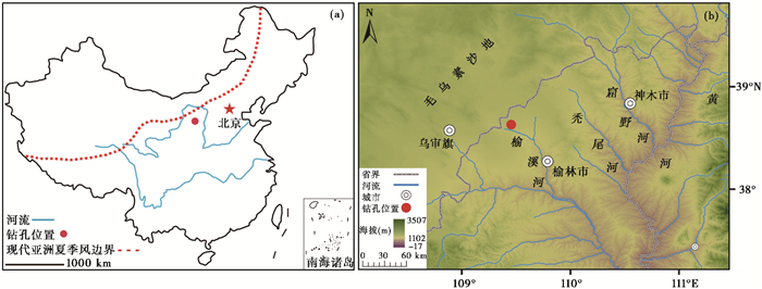
我国沙漠/黄土过渡带地处东亚夏季风尾闾区,水资源匮乏,生态系统脆弱,对气候变化响应敏感[1]。毛乌素沙地东南缘与黄土高原北部丘陵沟壑区接壤地带[2],是我国沙漠/黄土过渡带的典型区域[3](图 1a和1b)。独特的自然地理环境,使其成为全球变化研究的理想地区,受到广泛关注。科学家通过对沙漠/黄土过渡带内广泛分布的风成砂/黄土/古土壤沉积进行沉积相分析和地层空间对比,同时结合年代学、气候环境代用指标等研究方法,科学论证了冰期/间冰期长时间尺度上毛乌素沙地形成与演化、沙地时空分布、环境演变、季风环流变迁及与全球气候变化的联系等重要科学问题[1, 4~8]。近年来基于大范围沉积相调查工作和大量研究点位的批量测年结果,已基本确立毛乌素沙地在末次冰盛期(Last Glacial Maximum,简称LGM)和全新世大暖期(Holocene Megathermal)时的空间分布范围,这对特殊地质历史时期的古气候模拟、粉尘排放强度估算等有重要科学意义[9~11]。
|
图 1 (a) 现代亚洲季风边界线;(b)沙漠/黄土过渡带白河庙钻孔地理位置示意图 Fig. 1 (a)Modern Asian summer monsoon limit; (b)The geographical location of Baihemiao core in desert/loess transition zone |
植被是自然生态系统中最活跃的因子,花粉指标重建的区域性植被类型演替和空间格局变迁,是反映气候变化、沙地收缩与扩张、生态环境演变的直接证据。但是因为沙漠/黄土过渡带内缺乏可提供高分辨率花粉记录分析的地质档案,使得已有研究对全新世以来百年时间尺度上的植被演变历史关注较少[12~13]。
史前人类活动和自然环境变化之间的关系,一直是备受关注的科学问题[14~15]。环境考古学家通过对新石器时代考古遗址的数量、空间分布范围和气候变化进行关联性分析,认为气候变化对史前考古学文化的兴衰有重要影响[16~31]。例如,在北方甘青地区,降水变化而非温度,是影响马家窑文化演替的主要因素[19];全新世适宜期夏季风增强,降水增多,湿润的气候有利于考古聚落数量增加和人类活动空间范围扩大[17, 20, 28~29],反之亦然。但在中国南方福建地区,人类活动加强,农业文明发展是在夏季风衰弱,降水减少的气候背景下完成的,与全新世适宜期暖湿的气候形成明显滞后性[32];另外,极端气候突变事件引发的干旱、洪水等自然灾害是导致史前考古学文化衰退的重要自然因素[15, 33~35]。总体来看,目前气候变化影响人类活动的机制和过程还不清晰[16],需要结合自然科学和考古学对具体区域进行分析查验,才能为解释这一问题提供更多视角和科学依据。石峁、寨峁、新华等重要遗址的考古发掘及研究[36~38],充分证明沙漠/黄土过渡区是中华文明形成时重要的组成部分。较为清晰的考古学文化发展脉络和丰富的考古遗址,为开展典型生态脆弱区学科交叉研究,探索自然环境变化与人类活动之间的联系提供了丰富的素材。
泥炭沉积敏感地记录了区域气候环境信息,为建立高分辨率气候变化序列提供了良好的地质载体[39~40]。本文选择的白河庙钻孔位于沙漠/黄土过渡带中心地区,通过对泥炭沉积进行可靠的测年和高分辨率花粉指标分析,重建区域内中晚全新世古植被演替、生态系统演变及气候环境变化;同时结合考古资料,统计与气候变化序列处于同一时间框架内的考古遗址点分布信息,以此来尝试探索适宜气候环境阶段内和极端气候事件发生时考古遗址的时空分布变化规律,揭示人类活动变化的气候环境背景及其影响机制。
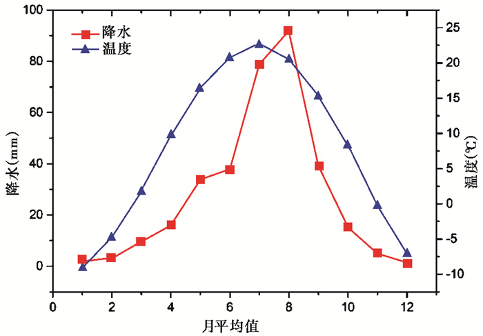
1 研究区自然环境概况2015年9月,使用冲击钻在榆林市白河庙村榆溪河滩地钻取岩芯。白河庙钻孔(38°35′9.89″N,109°24′0.71″E)位于黄土高原北部丘陵地貌向毛乌素沙地过渡地带,榆溪河下游,东距榆林市36 km(图 1b)。研究区属半干旱中温带大陆性季风气候,冬季受蒙古-西伯利亚高压影响,气候寒冷干燥,风沙活动频繁,夏季接受少量夏季风携带的水汽,气候暖湿。距离研究点最近的乌审旗气象站1981~2010年气象统计资料显示,该区域年均降水量约337 mm,降水集中在5~9月份,占全年降水总量的84 %,年均温约7.1 ℃(图 2)。研究点附近现代植被以禾本科、蒿类草原群落为主,低洼滩地为草甸、盐生草甸,柽柳(Tamarix)、沙柳(Salix psammophila)、柠条(Caragana korshinskii)等灌木被广泛栽培,形成大范围的人工灌木林。
|
图 2 乌审旗气象站1981~2010年降水和温度月值数据集 Fig. 2 Monthly average data set of precipitation and temperature in Wushenqi Weather Station in 1981~2010 |
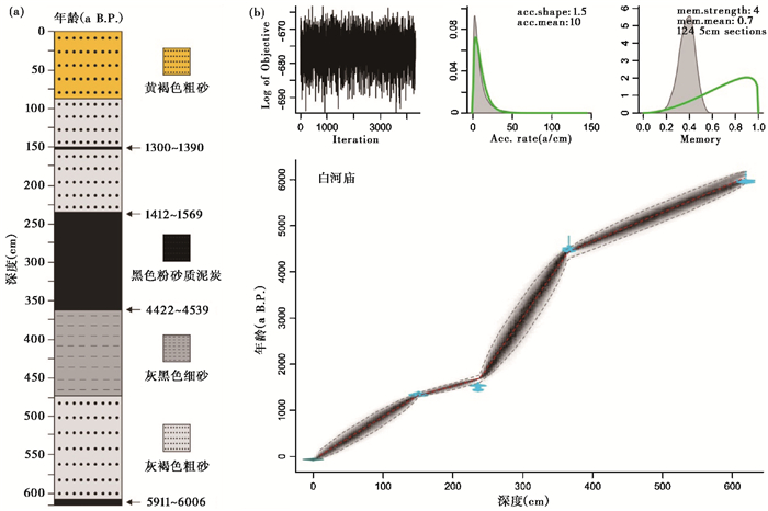
白河庙岩芯总厚6.19 m,根据不同的岩性,将岩芯从上至下划分如下(图 3a):
|
图 3 (a) 白河庙岩芯岩性及测年材料选择点;(b)Bacon年龄-深度模式建立的白河庙岩芯年代序列 Fig. 3 (a)Lithological characters and layers of dating materials of Baihemiao core; (b)Age sequence of Baihemiao core reconstructed by Bacon age-depth model |
0~ 88 cm,岩芯上部为黄褐色粗砂,含现代植物根系;
88~ 150 cm,灰褐色粗砂,偶见植物残体;
150~ 155 cm,黑色粉砂质泥炭,含丰富的植物花序;
155~ 235 cm,灰褐色粗砂;
235~ 366 cm,黑色粉砂质泥炭,分解度较差,保留大量植物茎秆、叶片、种子;
366~ 472 cm,灰黑色细砂,其中390~420 cm含较多植物茎秆;
472~ 615 cm,灰褐色粗砂;
615~ 619 cm,黑色粉砂质泥炭,含大量炭屑。
2.2 年代序列为建立白河庙泥炭沉积良好的年代框架,共选择植物种子、花序、炭屑、陆生植物残体等4个可靠的测年材料,送交Beta实验室进行AMS 14C定年(图 3a)。在获得14C年代后,使用OxCal v4.3.2和IntCal13软件将其校正为日历年龄[41~42]。以已测定的4个可靠年龄点为年代标尺,使用贝叶斯年龄模型软件Bacon 2.0年龄-深度模式[43],将泥炭沉积深度转换为年龄,建立岩芯的年代序列(图 3b)。
2.3 花粉分析以间隔10 cm或20 cm厚度为间距,共采集42块孢粉样品。泥炭样品用量为2 g,其余样品为50~100 g。综合使用筛选、酸碱处理、重液浮选等方法提取花粉[44~45],外加石松孢子以计算花粉浓度。在Zeiss AxioImager. A2生物显微镜400X下对样品中提取出的花粉进行鉴定和统计,花粉形态鉴定参照已发表的花粉图谱[46~48]。其中37个样品统计花粉至300粒,5个样品统计花粉至100~150粒。根据陆生植物花粉的统计数量,使用Tilia软件计算不同类型花粉百分比,同时通过CONISS地层约束聚类分析对花粉组合进行分带,绘制花粉图谱。因花粉浓度在中国北方草原区与植被盖度并不一定呈线性关系[49~50],因此本文计算的花粉浓度只做参考,并未在图谱中列出。选择干旱-半干旱地区具有可靠生态指示意义的蒿属/藜科(A/C)花粉含量比值,来反映气候的干湿变化[49, 51~53]。
3 史前考古遗址点的统计考古遗址点的时空分布模式,可证明史前人类活动与自然环境的联系。因此,为查验适宜气候环境阶段和极端气候事件对人类活动的影响,本文参照《中国文物地图集——陕西分册》[54]以及相关考古学研究成果[55],首先使用ArcGIS软件对相关考古遗址点进行数字化处理,之后围绕107°59′36.04″E以东和37°26′33.77″N以北沙漠/黄土过渡带核心区域,统计仰韶时期庙底沟文化到夏商时期(6~3 ka B.P.)不同考古学时代考古遗址点的数量、空间分布范围、海拔高度等地理信息。3 ka B.P.之后考古遗址点受周边地区不同经济基础国家的政治、军事、交通、屯垦政策等社会因素影响大,因此未做统计。毛乌素沙地内部的考古遗址受风沙活动、沙漠扩张等埋藏条件限制,保存状况差,目前发现的数量极少且考古学文化背景不清晰,因此本文未统计沙地内部的考古遗址。
4 研究结果 4.1 年代序列白河庙岩芯的测年结果见表 1,日历年龄显示白河庙岩芯底部619 cm深处的年代为6 cal.ka B.P. (表 1),基本涵盖了中晚全新世新石器时代考古学文化发展的关键时间段。另外,从Bacon模型[43]建立的年代序列和花粉样品量可计算出本文每个样品平均时间分辨率约为143年,基本符合高分辨率花粉分析的要求(图 3b)。
| 表 1 白河庙岩芯AMS 14C测年结果 Table 1 AMS 14C dating results of botanical materials of Baihemiao core |
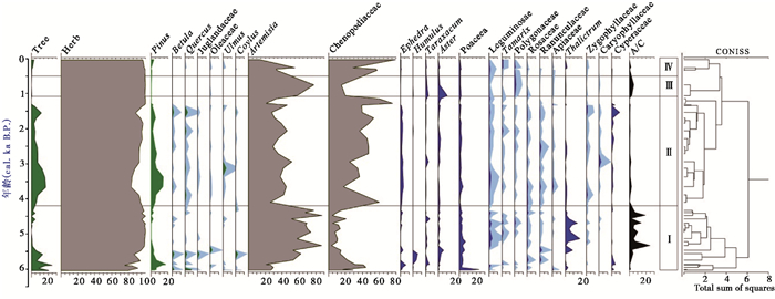
42个样品共鉴定花粉12921粒,分属30个科属(图 4),包括松属(Pinus)、云杉属(Picea)、冷杉属(Abies)、桦属(Betula)、栎属(Quercus)、柽柳属(Tamarix)、蒿属(Artemisia)、藜科(Chenopodiaceae)、禾本科(Poaceae)、豆科(Leguminosae)、唐松草属(Thalictrum)、莎草科(Cyperaceae)、麻黄属(Ephedra)、葎草属(Humulus)、狐尾藻属(Myriophyllum)、卷柏科(Selaginellaceae)等。其中,以蒿属、藜科为主的草本植物花粉百分含量(75 % ~99 %)占绝对优势,而以松属植物花粉为主的乔木花粉所占百分含量少(1 % ~24 %)(图 4)。
|
图 4 白河庙泥炭沉积中主要陆生植物花粉百分比图谱 Fig. 4 Percentage diagram of main terrestrial pollen types from Baihemiao peat |
以岩芯年代序列为基础,依据花粉百分比含量聚类分析,从下至上可将花粉谱划分为4个不同的花粉组合带(图 4)。
带Ⅰ(619~350 cm,6.0~4.2 ka B.P.):草本植物花粉含量高(75 % ~99 %),其中以蒿属(21 % ~87 %)花粉含量占优势,藜科(3 % ~44 %)、禾本科(1 % ~23 %)以及喜湿的唐松草属(0~15 %)花粉含量也较高。乔木花粉含量以松属(1 % ~17 %)为主,桦属、栎属、胡桃科(Juglandaceae)、木犀科(Oleaceae)、榛属(Corylus)花粉等在短时期内有零星出现。A/C比值由6.0~5.8 ka B.P.的0.6~1.6,持续升高到2.3~25.0。
带Ⅱ(350~121 cm,4.2~1.1 ka B.P.):草本植物花粉含量含量(83 % ~98 %)仍然很高,以藜科花粉为主(17 % ~76 %),蒿属(21 % ~52 %)、禾本科(0~4 %)、唐松草属(0~2 %)花粉含量低,较带Ⅰ明显下降。灌木麻黄属(0~3 %)花粉含量达到全序列最高值。莎草科花粉含量上升(0~9 %)。乔木植物花粉含量(0~17 %)小,以松属为主(0~14 %)。桦属(0~2 %)、栎属(0~4 %)花粉有一定含量,其余乔木花粉含量极少,均小于1 %。A/C比值为0.6~2.6,较带Ⅰ显著降低。
带Ⅲ(121~50 cm,1.1~0.5 ka B.P.):草本植物花粉含量高达99 %,蒿属花粉(58 % ~78 %)含量较带Ⅱ明显上升,藜科花粉(15 % ~20 %)含量下降。菊科紫菀属(Aster)(0~10 %)和蒲公英属(Taraxacum)花粉(1 % ~3 %)含量增加。乔木花粉极少出现或消失。A/C比值升高,在2.9~5.6之间。
带Ⅳ(50~0 cm,0.5 ka B.P.以来):草本植物花粉含量(97 % ~99 %)占绝对优势,以藜科花粉为主(58 % ~79 %),蒿属花粉(13 % ~55 %)较少。乔木花粉只零星出现在接近地表的沉积中,含量极低(0~3 %)。A/C比值下降,在0.1~1.9之间。
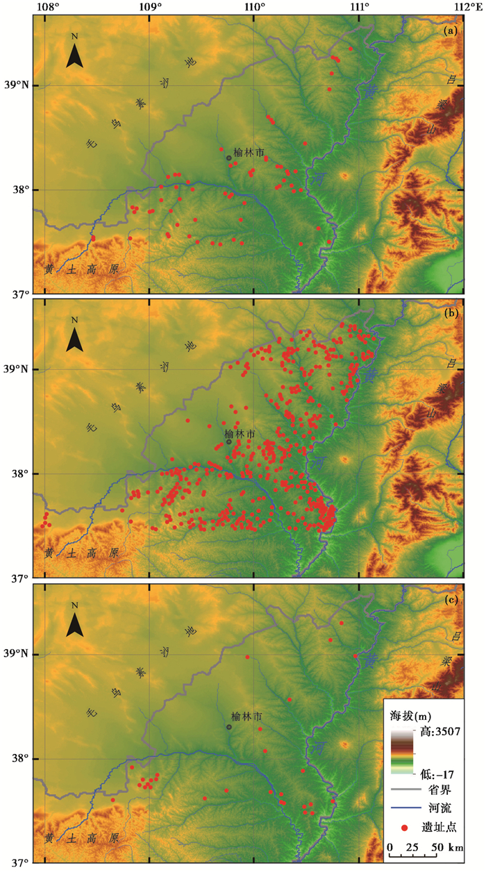
4.3 研究区6~3 ka B.P.考古遗址点时空分布格局图 5和表 2的统计信息表明,仰韶中晚期(6~5 ka B.P.)考古遗址点有65处,集中分布于河流谷地或阶地(图 5a)。龙山时期(5~4 ka B.P.)遗址点显著增多,共有509处,数量约为仰韶时期的8倍,遗址密度明显增大。遗址点密集分布于黄河、窟野河、秃尾河等主要河流的谷地、阶地。另外,遗址点向毛乌素沙地东南缘、海拔较高的丘陵地区大规模扩展(图 5b)。这表明龙山时期人口数量大幅增加,人类活动空前加强,人类活动范围达到最大。夏商时期(4~3 ka B.P.),遗址点数量急剧下降,仅有29处,遗址点密度大幅降低。遗址较为分散,多分布于海拔较低、水资源条件较好的地区(图 5c)。表明夏商时期人口急剧减少,人类活动空间范围大幅缩小。
|
图 5 6~3 ka B.P.考古遗址点空间分布信息 (a)仰韶中晚期6~5 ka B.P.;(b)龙山时期5~4 ka B.P.;(c)夏商时期4~3 ka B.P. Fig. 5 Spatial and temporal distribution information of archaeological sites in 6~3 ka B.P. (a)Middle and late Yangshao Period 6~5 ka B.P.; (b)Longshan Period 5~4 ka B.P.; (c)Xia and Shang Period 4~3 ka B.P. |
| 表 2 沙漠/黄土过渡区6~3 ka B.P.考古遗址点数量、空间分布范围、海拔高度统计信息 Table 2 Counting numbers of archaeological sites and their geographical information during 6~3 ka B.P. |
根据白河庙钻孔沉积的花粉组合以及重要花粉属种的生态特征(图 4),可将该地区中晚全新世气候变化划分为4个阶段:
阶段Ⅰ(6.0~4.2 ka B.P.),蒿属花粉含量上升,并保持高值,A/C比值随着蒿属花粉的增加而持续上升。藜科花粉含量下降,5.8 ka B.P.后百分比含量小于25 %。喜湿的唐松草属花粉含量达到整个年代序列的峰值。乔木植物花粉含量虽少,但种类多样,以松属(最高含量17 %)为主。松属花粉产量大,传播能力强,具有超代表性。当孢粉组合带中松属花粉含量小于30 %时,指示研究区内可能无松林发育[56]。因此,白河庙研究点周围可能并无松属植物生长,松属花粉可能通过风力或水流作用,从黄土高原丘陵或河谷地区搬运而来。花粉组合反映研究区植被为典型草原,可能伴生有少量乔木,指示夏季风较为强盛,降水较多,温暖湿润的气候条件。
阶段Ⅱ(4.2~1.1 ka B.P.),孢粉组合在4.2 ka B.P.后发生明显变化,蒿属花粉含量较阶段Ⅰ迅速下降,藜科花粉含量相应快速上升,之后保持高值,A/C比值小于2。指示干旱气候的麻黄属花粉含量明显增加。花粉组合显示区域范围内植被为荒漠草原,而快速扩张的耐干旱植被,揭示4.2 ka B.P.突变的气候干旱事件,以及之后持续的干旱化。但花粉组合中喜湿的莎草科花粉含量增加,榆属、栎属等乔木有零星出现,结合该阶段发育以莎草科植物为主的泥炭等证据,证明研究区附近湖泊和河漫滩等局地环境较为湿润。
阶段Ⅲ(1.1~0.5 ka B.P.),蒿属花粉含量及A/C比值较阶段Ⅱ快速上升,藜科花粉含量的变化趋势与蒿属花粉相反。花粉组合表明,1.1~0.5 ka B.P.期间,研究区植被由阶段Ⅱ的荒漠草原短暂恢复为干草原,指示气候条件改善,降水增多,湿度增大。
阶段Ⅳ(0.5 ka B.P.以来),草本植物花粉以藜科为主,植被群落单一。A/C比值低,可能与过渡放牧和人类活动有关系[49]。花粉组合表明,0.5 ka B.P.后植被退化为荒漠草原,指示降水减少,湿度减小,气候再次向干旱化转变。
5.2 沙漠/黄土过渡带气候环境变化对人类活动的影响 5.2.1 中晚全新世气候变化的区域环境效应白河庙泥炭沉积花粉记录显示,6.0~4.2 ka B.P.东亚夏季风带来的降水较多,气候湿润,为全新世适宜期(Holocene Optimum)。适宜的气候有利于良好生态环境的建立和持续稳定发展,使得区域内发育典型草原。这种环境效应在沙漠/黄土过渡带内多个黄土/古土壤剖面中都有记录。例如,榆林剖面磁化率、总有机碳含量在6.0~4.2 ka B.P.处于高值,区域植被生产力较高[57];三道沟剖面7.5~4.0 ka B.P.气候湿润,古土壤中粉砂和粘粒成分所占比例显著增加[58]。多个风成砂/古土壤剖面沉积相变化显示,全新世适宜期毛乌素沙地水分条件较好,广泛发育较厚砂质古土壤层,沙地收缩,沙丘基本被固定,沙漠/黄土过渡带向西北中纬度干旱区移动[9~11, 59~60]。和林格尔、姬塬、韩家梁、蔡家沟等黄土/古土壤剖面孢粉记录表明沙漠/黄土过渡带在10~4 ka B.P.发育草甸草原,并伴生有乔木,植被群落发育好[61~62]。另外,季风边缘区其他重要湖泊、泥炭沉积载体中均有类似的环境效应记录,例如,岱海、察素齐地区分别在7.90~4.45 ka B.P.和5.0~4.1 ka B.P.气候温暖湿润,发育针阔叶混交林[63~64];调角海子7.1~4.4 ka B.P.孢粉通量最高,盘星藻含量高,在山地发育以松属、桦属和栎属为主的针阔叶混交林[65]。黄土高原西部在8~4 ka B.P.气候暖湿,河流谷地森林植被繁茂,植被盖度高,形成广阔的湿地/沼泽相地层[66~67]。C4植物分布与东亚夏季风强度有关,全新世适宜期黄土高原C4植物增加,并向西北扩张[68]。
4.2 ka B.P.白河庙地区气候突然变干,季风降水快速减少。4.2 ka B.P.事件可能是全球性的气候突变事件,在我国季风区及全球范围内多种地质载体中均有广泛记录[69~72]。黄土高原东部莲花洞石笋δ18 O表明,东亚夏季风在全新世适宜期后快速衰退,导致中国北方全新世在4 ka B.P.出现干旱[73];多个研究点的植被综合形成的湿度曲线表明,全新世季风边缘区最大湿度出现在中全新世8~4 ka B.P.,最干旱的环境在晚全新世4 ka B.P.后[74];4.2 ka B.P.极端气候事件,导致全新世气候适宜期结束,气候由湿润向干旱化转型[75]。季风边缘区生态系统对这一重要气候转型期响应明显。由于降水减少,植被盖度降低,4.4 ka B.P.后呼伦贝尔沙地内部沉积风成砂,沙丘活化,沙地扩张加剧[76];呼伦湖在4.40~3.35 ka B.P.发育以藜科为主的荒漠草原,气候极其干旱[77];达里湖湖泊水位在4.45~3.75 ka B.P.大幅降低[78];4.5 ka B.P.后青海湖区气候变冷干,特别是在3.9 ka B.P.后孢粉浓度、碳酸盐、总有机碳、总氮含量迅速减少,蒿属草原扩张,湖泊生产力下降[79]。
5.2.2 适宜的气候环境阶段和极端气候事件对人类活动的影响关中盆地鱼化寨遗址植物种子浮选结果表明,仰韶晚期(5.0~5.5 ka B.P.)甚至庙底沟文化时,以粟黍为主的北方旱作农业已取代狩猎采集,成为最主要的经济主体[80]。史前旱作农业体系的确立,农业生产增加,使先民有较为充足的食物来源,人口规模不断扩大[17, 81~82]。关中盆地的古代先民在仰韶中晚期,开始向周边地区扩散[83],而该时间段内沙漠/黄土过渡带受东亚夏季风影响,气候适宜,降水较多,毛乌素沙地向西北方向收缩。同时水资源较为丰富,植被群落发育良好,植被盖度高,成壤作用加强,发育古土壤层。适宜的自然环境和气候条件,有利于旱作农业生产和古代先民定居。考古遗址点统计信息表明(图 5和表 2),6~5 ka B.P.庙底沟文化因素已经扩展到陕北沙漠/黄土过渡带。但该时间段内遗址点数量较少;到5~4 ka B.P.时,沙漠/黄土过渡带遗址点数量呈现爆发式增长,遗址密度大幅增加,这与适宜而且稳定的气候、农业经济发展、人口大量增加有密切联系。水资源是干旱/半干旱地区影响农业活动和人类生存的重要自然因子[14]。龙山时期古代先民多选择沙漠/黄土过渡带内主要河流的谷地和阶地定居[84],说明水资源的获取与利用是先民定居和开展农业活动优先考虑的因素。另外,龙山晚期古代先民开始修筑多个规模较大的石城。其中石峁城址为超大型中心聚落,面积约400万平方米,是目前发现的中国史前最大的城址[36]。
东亚夏季风降水变化是影响我国北方干旱/半干旱地区生态系统最重要的自然因子[85],而大范围生态系统的突变则对人类生存策略和人类活动产生深远影响。在季风边缘区的浑善达克沙地,4.2 ka B.P.气候突变事件导致沙地内部水文系统快速转变,河流水位迅速降低,湖泊消失,地下水位大幅下降。由此造成生态系统破坏,引发不可逆的沙漠化,导致人类活动明显衰退[75]。4.2 ka B.P.后气候条件不稳定,气象灾害频发,如黄河中游泾河、七水河、北洛河等多地爆发大洪水,破坏了原有的人类生存条件,导致人类居址废弃[34, 87~88]。另外,甘青地区的齐家文化[21]、山东龙山文化[15]、长江中下游地区的石家河文化、良渚文化等在4.2 ka B.P.后大范围衰退可能均与气候突变事件及频繁的气象灾害有关[33, 35]。而沙漠/黄土过渡区4.2 ka B.P.发生的极端干旱事件,以及夏季风衰退引发的长期干旱,导致水资源匮乏,植被退化,风沙活动加强,沙漠化发展,毛乌素沙地向东南方向的沙漠/黄土过渡带扩张;同时大范围内降水持续减少,导致河流水量减小,湖泊干涸[89]。水分条件的大规模重组造成生态系统破坏,环境承载力降低,土地利用条件退化,对龙山时期水分变化响应敏感的以粟为主的旱作农业造成严重影响[90]。由于农业经济衰退,人口数量锐减,考古遗址点随之大幅减少,空间分布范围缩小,考古学文化衰退。
6 结论白河庙泥炭沉积高分辨率孢粉记录表明,研究区6.0~4.2 ka B.P.发育典型草原,同时伴生少量乔木,植物种类多样,群落发育良好,指示夏季风强盛,降水较多,气候温暖湿润。4.2 ka B.P.时,以藜科为主的荒漠草原快速扩张,表明极端干旱事件发生。4.2 ka B.P.后,虽然在1.1~0.5 ka B.P.期间植被短暂恢复为草原,但总体上植被以荒漠草原为主,植物种类少,群落结构简单。植被类型演替过程表明4.2 ka B.P.后夏季风明显衰退,降水减少,气候逐渐干旱化。
季风变化控制的水资源分布以及与水资源密切相关的旱作农业发展,是影响人类活动的重要机制。6.0~4.2 ka B.P.湿润的气候推动沙漠/黄土过渡带向西北移动,较为充足的水资源和良好的生态环境促进了农业发展,使得仰韶时期和龙山时期的人口数量不断增加,人类活动逐渐加强,人类活动范围明显扩大。4.2 ka B.P.极端干旱事件及之后持续的干旱化,导致生态系统退化、沙漠扩张,沙漠/黄土过渡带向东南摆动。水资源短缺和旱作农业经济体系破坏,引发夏商时期人类活动大范围衰退。
致谢: 感谢审稿专家和杨美芳老师提出的重要修改意见;感谢地理空间数据云提供榆林地区DEM高程数据,国家气象科学数据共享服务平台提供乌审旗站点气象资料。
| [1] |
孙继敏, 丁仲礼, 刘东生. 50万a来沙漠-黄土边界带的环境演变[J]. 干旱区地理, 1995, 18(4): 1-9. Sun Jimin, Ding Zhongli, Liu Dongsheng. Environmental evolution of the desert-loess transitional zone over the last 0.5 Ma[J]. Arid Land Geography, 1995, 18(4): 1-9. |
| [2] |
陈淑娥, 樊双虎, 刘秀花, 等. 陕西榆林风沙滩区全新世气候和环境变迁[J]. 地球科学与环境学报, 2010, 32(1): 81-88. Chen Shu'e, Fan Shuanghu, Liu Xiuhua, et al. Climate and environmental changes in the eolian sand section of Yulin, Shaanxi Province[J]. Journal of Earth Sciences and Environment, 2010, 32(1): 81-88. |
| [3] |
杨利荣. 末次冰期以来陕北沙漠-黄土过渡带气候记录与环境变迁[D]. 西安: 西北大学硕士论文, 2004: 3-6. Yang Lirong. Climatic Records and Environmental Evolution of the Desert-Loess Transitional Zone in the North of Shaanxi Province since the Last Glacial[D]. Xi'an: The Master Thesis of Northwest University, 2004: 3-6. |
| [4] |
孙继敏, 丁仲礼, 刘东生, 等. 末次间冰期以来沙漠-黄土边界带的环境演变[J]. 第四纪研究, 1995(2): 117-122. Sun Jimin, Ding Zhongli, Liu Dongsheng, et al. Environmental changes in the desert-loess transitional zone of North China since beginning of the last interglacial[J]. Quaternary Sciences, 1995(2): 117-122. |
| [5] |
董光荣, 靳鹤龄, 陈惠忠. 末次间冰期以来沙漠-黄土边界带移动与气候变化[J]. 第四纪研究, 1997(2): 158-167. Dong Guangrong, Jin Heling, Chen Huizhong. Desert-loess boundary belt shift and climatic changes since the last interglacial period[J]. Quaternary Sciences, 1997(2): 158-167. |
| [6] |
董光荣, 陈惠忠, 王贵勇, 等. 150 ka以来中国北方沙漠、沙地演化和气候变化[J]. 中国科学:化学, 1995, 25(12): 1303-1312. Dong Guangrong, Chen Huizhong, Wang Guiyong, et al. Desert evolution and climate change of desert in Northern China since 150 ka BP[J]. Science in China:Chemistry, 1995, 25(12): 1303-1312. |
| [7] |
Sun J M, Yin G M, Ding Z L, et al. Thermoluminescence chronology of sand profiles in the Mu Us Desert, China[J]. Paleogeography, Paleoclimatology, Paleoecology, 1998, 144(1-2): 225-233. DOI:10.1016/S0031-0182(98)00082-0 |
| [8] |
Sun J M, Ding Z L, Rokosh D, et al. 580, 000 year environmental reconstruction from eolian deposits at the Mu Us Desert margin, China[J]. Quaternary Science Reviews, 1999, 18(12): 1351-1364. DOI:10.1016/S0277-3791(98)00086-9 |
| [9] |
Lu H Y, Yi S W, Xu Z W, et al. Chinese deserts and sand fields in Last Glacial Maximum and Holocene Optimum[J]. Chinese Science Bulletin, 2013, 58(23): 2775-2783. DOI:10.1007/s11434-013-5919-7 |
| [10] |
郭正堂, 羊向东, 陈发虎, 等. 末次冰盛期以来我国气候环境变化及人类适应[J]. 科学通报, 2014, 59(30): 2937-2939. Guo Zhengtang, Yang Xiangdong, Chen Fahu, et al. Climate changes in China since the Last Glacial Maximum and Holocene human adaptation[J]. Chinese Science Bulletin, 2014, 59(30): 2937-2939. |
| [11] |
徐志伟, 鹿化煜, 弋双文, 等. 末次盛冰期和全新世大暖期毛乌素沙地的空间变化[J]. 第四纪研究, 2013, 33(2): 218-227. Xu Zhiwei, Lu Huayu, Yi Shuangwen, et al. Spatial variations of the Mu Us dune filed(north Central China) during the Last Glacial Maximum and Holocene Optimum[J]. Quaternary Sciences, 2013, 33(2): 218-227. |
| [12] |
Li X Q, Zhou W J, An Z S, et al. The vegetation and monsoon variations at the desert-loess transition belt at Midiwan in Northern China for the last 13 ka[J]. The Holocene, 2003, 13(13): 779-784. |
| [13] |
李小强, 周卫建, 安芷生, 等. 沙漠/黄土过渡带13 ka BP以来季风演化的古植被记录[J]. 植物生态学报, 2000, 42(8): 868-872. Li Xiaoqiang, Zhou Weijian, An Zhisheng, et al. The palaeovegetation record of monsoon evolution in the desert/loess transition zone for the last 13 ka BP[J]. Acta Botanica Sinica, 2000, 42(8): 868-872. |
| [14] |
吕厚远, 张健平. 关中地区的新石器古文化发展与古环境变化的关系[J]. 第四纪研究, 2008, 28(6): 1050-1060. Lü Houyuan, Zhang Jianping. Neolithic cultural evolution and Holocene climate change in the Guanzhong Basin, Shaanxi, China[J]. Quaternary Sciences, 2008, 28(6): 1050-1060. |
| [15] |
Gao H Z, Zhu C, Xu W F. Environmental change and cultural response around 4200 cal. yr BP in the Yishu River basin, Shandong[J]. Journal of Geographical Sciences, 2007, 17(3): 285-292. DOI:10.1007/s11442-007-0285-5 |
| [16] |
董广辉. 甘青地区新石器文化演化及其环境动力研究进展与展望[J]. 海洋地质与第四纪地质, 2013, 33(4): 67-75. Dong Guanghui. Neolithic cultural evolution and its environmental driving force in the Gansu-Qinghai region:Problems and perspectives[J]. Marine Geology & Quaternary Geology, 2013, 33(4): 67-75. |
| [17] |
董广辉, 刘峰文, 杨谊时, 等. 黄河流域新石器文化的空间扩张及其影响因素[J]. 自然杂志, 2016, 38(4): 248-252. Dong Guanghui, Liu Fengwen, Yang Yishi, et al. Cultural expansion and its influencing factors during Neolithic Period in the Yellow River valley, Northern China[J]. Chinese Journal of Nature, 2016, 38(4): 248-252. |
| [18] |
Dong G H, Jia X, An C B, et al. Mid-Holocene climate change and its effect on prehistoric cultural evolution in eastern Qinghai Province, China[J]. Quaternary Research, 2012, 77(1): 23-30. DOI:10.1016/j.yqres.2011.10.004 |
| [19] |
Dong G H, Wang L, Cui Y F, et al. The spatiotemporal pattern of the Majiayao cultural evolution and its relation to climate change and variety of subsistence strategy during late Neolithic period in Gansu and Qinghai provinces, Northwest China[J]. Quaternary International, 2013, 316(459): 155-161. |
| [20] |
Dong G H, Jia X, Elston R, et al. Spatial and temporal variety of prehistoric human settlement and its influencing factors in the upper Yellow River valley, Qinghai Province, China[J]. Journal of Archaeological Science, 2013, 40(5): 2538-2546. DOI:10.1016/j.jas.2012.10.002 |
| [21] |
An C B, Tang L Y, Barton L, et al. Climate change and cultural response around 4000 cal yr B.P. in the western part of Chinese Loess Plateau[J]. Quaternary Research, 2005, 63(3): 347-352. DOI:10.1016/j.yqres.2005.02.004 |
| [22] |
安成邦, 王琳, 吉笃学, 等. 甘青文化区新石器文化的时空变化和可能的环境动力[J]. 第四纪研究, 2006, 26(6): 923-927. An Chengbang, Wang Lin, Ji Duxue, et al. The temporal and spatial changes of Neolithic cultures in Gansu-Qinghai region and possible environmental forcing[J]. Quaternary Sciences, 2006, 26(6): 923-927. |
| [23] |
王建军, 胡珂, 鲁鹏, 等. 陕西榆林和河南洛阳地区4 ka BP前后聚落演化差异及其古气候原因[J]. 古地理学报, 2015, 17(6): 841-850. Wang Jianjun, Hu Ke, Lu Peng, et al. Difference and its palaeoclimate reason of settlement evolution between Yulin area of Shaanxi Province around 4 ka BP[J]. Journal of Palaeogeography, 2015, 17(6): 841-850. DOI:10.7605/gdlxb.2015.06.069 |
| [24] |
胡珂, 莫多闻, 毛龙江, 等. 榆林地区全新世聚落时空变化与人地关系[J]. 第四纪研究, 2010, 30(2): 344-355. Hu Ke, Mo Duowen, Mao Longjiang, et al. Temporal and spatial distribution of the Yangshao Age to West Zhou Dynasty's settlement sites in the Yulin area and human-earth relationships[J]. Quaternary Sciences, 2010, 30(2): 344-355. |
| [25] |
侯光良, 许长军, 曹广超, 等. 青藏高原末次冰消期-全新世中期人类扩张的时空模拟[J]. 第四纪研究, 2017, 37(4): 709-720. Hou Guangliang, Xu Changjun, Cao Guangchao, et al. The spatial-temporal simulation of mankind's expansion on the Tibetan Plateau during last deglaciation-Middle Holocene[J]. Quaternary Sciences, 2017, 37(4): 709-720. |
| [26] |
Jia X, Sun Y G, Wang L, et al. The transition of human subsistence strategies in relation to climate change during the Bronze Age in the West Liao River basin, Northeast China[J]. The Holocene, 2016, 26(5): 781-789. DOI:10.1177/0959683615618262 |
| [27] |
Jia X, Yi S W, Sun Y G, et al. Spatial and temporal variations in prehistoric human settlement and their influencing factors on the south bank of the Xar Moron River, Northeastern China[J]. Frontiers of Earth Science, 2017, 11(1): 137-147. DOI:10.1007/s11707-016-0572-5 |
| [28] |
Li Z X, Zhu C, Wu G X, et al. Spatial pattern and temporal trend of prehistoric human sites and its driving factors in Henan Province, Central China[J]. Journal of Geographical Sciences, 2015, 25(9): 1109-1121. DOI:10.1007/s11442-015-1222-7 |
| [29] |
Richerson P J, Boyd R, Bettinger R L. Was agriculture impossible during the Pleistocene but mandatory during the Holocene? A climate change hypothesis[J]. American Antiquity, 2001, 66(3): 387-411. DOI:10.2307/2694241 |
| [30] |
张山佳, 董广辉. 青藏高原东北部青铜时代中晚期人类对不同海拔环境的适应策略探讨[J]. 第四纪研究, 2017, 37(4): 696-708. Zhang Shanjia, Dong Guanghui. Human adaptation strategies to different altitude environment during mid-late Bronze Age in northeast Tibetan Plateau[J]. Quaternary Sciences, 2017, 37(4): 696-708. |
| [31] |
张振, 李佳, 王春癑, 等. 冀中南地区新石器时代至春秋时期聚落遗址时空分布及环境演变的影响[J]. 第四纪研究, 2017, 37(3): 474-485. Zhang Zhen, Li Jia, Wang Chunyue, et al. The temporal and spatial distribution of settlement sites and the influence of environmental changes since the Neolithic to Chunqiu periods in central and southern Hebei Province[J]. Quaternary Sciences, 2017, 37(3): 474-485. |
| [32] |
Zhao L, Ma C M, Leipe C, et al. Holocene vegetation dynamics in response to climate change and human activities derived from pollen and charcoal records from Southeastern China[J]. Palaeogeography, Palaeoclimatology, Palaeoecology, 2017, 485: 644-660. DOI:10.1016/j.palaeo.2017.06.035 |
| [33] |
Wu W X, Liu T S. Possible role of the "Holocene Event 3" on the collapse of Neolithic Cultures around the Central Plain of China[J]. Quaternary International, 2004, 117(1): 153-166. DOI:10.1016/S1040-6182(03)00125-3 |
| [34] |
Huang C C, Pang J L, Zha X C, et al. Extraordinary floods of 4100-4000 a BP recorded at the late Neolithic ruins in the Jinghe River Gorges, middle reach of the Yellow River, China[J]. Palaeogeography, Palaeoclimatology, Palaeoecology, 2010, 289(1-4): 1-9. DOI:10.1016/j.palaeo.2010.02.003 |
| [35] |
王巍. 公元前2000年前后我国大范围文化变化原因探讨[J]. 考古, 2004, 67(1): 67-77. Wang Wei. Reasons for cultural alternation in a vast territory of China around 2000 BC[J]. Archaeology, 2004, 67(1): 67-77. |
| [36] |
孙周勇, 邵晶, 邵安定, 等. 陕西神木县石峁遗址[J]. 考古, 2013(7): 15-24. Sun Zhouyong, Shao Jing, Shao Anding, et al. The Shimao site in Shenmu County of Shaanxi Province[J]. Archaeology, 2013(7): 15-24. |
| [37] |
陕西省考古研究所. 陕西神木县寨峁遗址发掘简报[J]. 考古与文物, 2002(3): 3-18. Shaanxi Provincial Institute of Archaeology. The excavation of Zhaimao site in Shenmu County[J]. Archaeology and Cultural Relics, 2002(3): 3-18. |
| [38] |
邢福来, 李明, 孙周勇. 陕西神木新华遗址1999年发掘简报[J]. 考古与文物, 2002(1): 3-12. Xing Fulai, Li Ming, Sun Zhouyong. An excavation of Xinhua site in 1999[J]. Archaeology and Cultural Relics, 2002(1): 3-12. |
| [39] |
王庆锋, 金会军, 吴青柏, 等. 距今约6000年以来青藏高原东北部黄河源区冻结泥炭沉积记录的气候演化[J]. 第四纪研究, 2017, 37(2): 402-415. Wang Qingfeng, Jin Huijun, Wu Qingbai, et al. Climatic evolution since 6 cal.ka B.P. recorded by frozen peat deposits in the source area of the Yellow River, northeastern Qinghai-Tibet Plateau[J]. Quaternary Sciences, 2017, 37(2): 405-415. |
| [40] |
周云鹏, 胡忠行, 张曼, 等. 浙江望东篛亚高山沼泽泥炭磁性特征及其环境意义[J]. 第四纪研究, 2017, 37(6): 1348-1356. Zhou Yunpeng, Hu Zhongxing, Zhang Man, et al. Magnetic properties of the Wangdongyang subalpine peatland in Zhejiang Province, Eastern China and its paleoenvironmental implications[J]. Quaternary Sciences, 2017, 37(6): 1348-1356. |
| [41] |
Reimer P J, Bard E, Bayliss A, et al. IntCal13 and Marine 13 radiocarbon age calibration curves 0-50, 000 years cal BP[J]. Radiocarbon, 2013, 55(4): 1869-1887. DOI:10.2458/azu_js_rc.55.16947 |
| [42] |
Bronk R C. OxCal v4. 3. 2[CP]. 2017, https://c14.arch.ox.ac.uk/oxcal/OxCal.html.
|
| [43] |
Blaauw M, Christen J A. Flexible paleoclimate age-depth models using an autoregressive gamma process[J]. Bayesian Analysis, 2011, 6(6): 457-474. |
| [44] |
李小强, 尚雪, 周新郢, 等. 黄土花粉分析的筛析——重液综合法[J]. 干旱区地理, 2006, 29(5): 663-667. Li Xiaoqiang, Shang Xue, Zhou Xinying, et al. Integrative method of sieving and heavy liquid in pollen analysis of loess[J]. Arid Land Geography, 2006, 29(5): 663-667. |
| [45] |
李育, 王乃昂, 许清海, 等. 中国北方第四纪孢粉提取方法研究[J]. 沉积学报, 2007, 25(1): 124-130. Li Yu, Wang Nai'ang, Xu Qinghai, et al. Investigation of Quaternary pollen and spores extraction methods in North China[J]. Acta Sedimentologica Sinica, 2007, 25(1): 124-130. |
| [46] |
席以珍, 宁建长. 中国干旱半干旱地区花粉形态研究[J]. Yushania, 1994(11): 119-191. Xi Yizhen, Ning Jianchang. Study on pollen morphology of plants from dry and semidry area in China[J]. Yushania, 1994(11): 119-191. |
| [47] |
王伏雄, 钱南芬, 张玉龙, 等. 中国植物花粉形态[M]. 第二版. 北京: 科学出版社, 1997: 1-461. Wang Fuxiong, Qian Nanfen, Zhang Yulong, et al. Pollen Flora of China[M]. Second Edition. Beijing: Science Press, 1997: 1-461. |
| [48] |
唐领余. 中国第四纪孢粉图鉴[M]. 北京: 科学出版社, 2016: 1-601. Tang Lingyu. An Illustrated Handbook of Quaternary Pollen[M]. Beijing: Science Press, 2016: 1-601. |
| [49] |
李月丛, 许清海, 阳小兰, 等. 中国草原区主要群落类型花粉组合特征[J]. 生态学报, 2005, 25(3): 555-564. Li Yuecong, Xu Qinghai, Yang Xiaolan, et al. Pollen assemblages of major steppe communities in China[J]. Acta Ecologica Sinica, 2005, 25(3): 555-564. |
| [50] |
许清海, 李月丛, 阳小兰, 等. 北方草原区主要群落类型表土花粉分析[J]. 地理研究, 2005, 24(3): 394-402. Xu Qinghai, Li Yuecong, Yang Xiaolan, et al. Study on surface pollen of major steppe communities in Northern China[J]. Geographical Research, 2005, 24(3): 394-402. |
| [51] |
翁成郁, 孙湘君, 陈因硕. 西昆仑地区表土花粉组成特征及与植被的数量关系[J]. 植物学报, 1993, 35(1): 69-79. Weng Chengyu, Sun Xiangjun, Chen Yinshuo. Numerical characteristics of pollen assemblages of surface samples from the west Kunlun Mountains[J]. Acta Botanica Sinica, 1993, 35(1): 69-79. |
| [52] |
El-Moslimany A P. Ecological significance of common nonarboreal pollen:Examples from drylands of the Middle East[J]. Review of Palaeobotany and Palynology, 1990, 64(1): 343-350. |
| [53] |
Liu H Y, Cui H T, Pott R, et al. The surface pollen of the woodland-steppe ecotone in south eastern Inner Mongolia, China[J]. Review of Palaeobotany and Palynology, 1999, 105(3-4): 237-250. DOI:10.1016/S0034-6667(98)00074-8 |
| [54] |
国家文物局. 中国文物地图集——陕西分册[M]. 西安: 西安地图出版社, 1998: 1-57. State Administration of Cultural Heritage. Atlas of Chinese Cultrual Relics-Shaanxi Province[M]. Xi'an: Xian Cartographic Press, 1998: 1-57. |
| [55] |
杨亚长, 马明志, 胡松梅, 等. 陕西史前考古的发现和研究[J]. 考古与文物, 2008(6): 17-65. Yang Yachang, Ma Mingzhi, Hu Songmei, et al. Archaeological discoveries and researches of the Xia-Shang-Zhou dynasties in Shaanxi Province[J]. Archaeology and Cultural Relics, 2008(6): 17-65. |
| [56] |
李文漪. 中国第四纪植被与环境[M]. 北京: 科学出版社, 1998: 1-253. Li Wenyi. Vegetation and Environment in Quaternary of China[M]. Beijing: Science Press, 1998: 1-253. |
| [57] |
Lu H Y, Yi S W, Liu Z Y, et al. Variation of East Asian monsoon precipitation during the past 21 k.y. and potential CO 2 forcing[J]. Geology, 2013, 41(9): 1023-1026. DOI:10.1130/G34488.1 |
| [58] |
高尚玉, 陈渭南, 靳鹤龄, 等. 全新世中国季风区西北缘沙漠演化初步研究[J]. 中国科学(B辑), 1993, 23(2): 202-208. Gao Shangyu, Chen Weinan, Jin Heling, et al. Preliminary research of desert succession in northwest monsoon boundary since Holocene[J]. Science in China (Series B), 1993, 23(2): 202-208. |
| [59] |
Li Q, Wu H B, Guo Z T, et al. Distribution and vegetation reconstruction of the deserts of Northern China during the mid-Holocene[J]. Geophysical Research Letters, 2014, 41(14): 5184-5191. DOI:10.1002/2014GL059952 |
| [60] |
Li Q, Wu H B, Yu Y Y, et al. Reconstructed moisture evolution of the deserts in Northern China since the Last Glacial Maximum and its implications for the East Asian summer monsoon[J]. Global and Planetary Change, 2014, 121(10): 101-112. |
| [61] |
杨青, 李小强, 周新郢, 等. MIS 3阶段以来沙漠/黄土过渡区植被演替及其对气候变化的响应[J]. 第四纪研究, 2011, 31(6): 962-971. Yang Qing, Li Xiaoqiang, Zhou Xinying, et al. Vegetation succession and its response to climate changes since MIS 3 in desert-loess transition belt, Northern China[J]. Quaternary Sciences, 2011, 31(6): 962-971. |
| [62] |
杨青, 李小强, 周新郢. 末次盛冰期以来沙漠-黄土过渡带植被演替及其对气候变化的响应[J]. 人类学学报, 2016, 35(3): 469-480. Yang Qing, Li Xiaoqiang, Zhou Xinying. Vegetation succession in response to climate changes since the LGM in the desert-loess transition zone, North China[J]. Acta Anthropologica Sinica, 2016, 35(3): 469-480. |
| [63] |
Xiao J L, Xu Q H, Nakamura T, et al. Holocene vegetation variation in the Daihai Lake region of north-central China:A direct indication of the Asian monsoon climatic history[J]. Quaternary Science Reviews, 2004, 23(14): 1669-1679. |
| [64] |
王琫瑜, 孙湘君. 内蒙古察素齐泥炭剖面全新世古环境变迁的初步研究[J]. 科学通报, 1997, 42(5): 514-518. Wang Bengyu, Sun Xiangjun. Preliminary study of Holocene environmental change of Chasuqi peatland section in Inner Mongolia[J]. Chinese Science Bulletin, 1997, 42(5): 514-518. |
| [65] |
Shi P J, Song C Q. Palynological records of environmental changes in the middle part of Inner Mongolia, China[J]. Chinese Science Bulletin, 2003, 48(14): 1433-1438. DOI:10.1360/02wd0259 |
| [66] |
安成邦, 冯兆东, 唐领余. 黄土高原西部全新世中期湿润气候的证据[J]. 科学通报, 2003, 48(21): 2280-2287. An Chengbang, Feng Zhaodong, Tang Lingyu. Evidence of humid mid-Holocene in the western part of Chinese Loess Plateau[J]. Chinese Science Bulletin, 2003, 48(22): 2472-2479. |
| [67] |
Feng Z D, An C B, Tang L Y, et al. Stratigraphic evidence of a Megahumid climate between 10, 000 and 4000 years B.P. in the western part of the Chinese Loess Plateau[J]. Global and Planetary Change, 2004, 43(3-4): 145-155. DOI:10.1016/j.gloplacha.2004.05.001 |
| [68] |
Yang S L, Ding Z L, Li Y Y, et al. Warming-induced north westward migration of the East Asian monsoon rain belt from the Last Glacial Maximum to the mid-Holocene[J]. Proceedings of the National Academy of Sciences of the United States of America, 2015, 112(43): 13178-13183. DOI:10.1073/pnas.1504688112 |
| [69] |
Bond G, Showers W, Cheseby M, et al. A pervasive millennial-scale cycle in north Atlantic Holocene and glacial climates[J]. Science, 1997, 278(7): 2402-2415. |
| [70] |
王绍武. 4.2 ka BP事件[J]. 气候变化研究进展, 2010, 6(1): 75-76. Wang Shaowu. 4.2 ka BP event[J]. Advances in Climate Change Research, 2010, 6(1): 75-76. |
| [71] |
刘浴辉, 孙霞, 郭彩青. 中国全新世4.2 ka BP气候事件及其对古文明的影响[J]. 地质科技情报, 2013, 32(1): 99-106. Liu Yuhui, Sun Xia, Guo Caiqing. Records of 4.2 ka BP Holocene event from China and its impact on ancient civilizations[J]. Geological Science and Technology Information, 2013, 32(1): 99-106. |
| [72] |
牛蕊, 周立旻, 孟庆浩, 等. 贵州草海南屯泥炭记录的中全新世以来的气候变化[J]. 第四纪研究, 2017, 37(6): 1357-1369. Niu Rui, Zhou Limin, Meng Qinghao, et al. The paleoclimate variations of the Nantun peat in the Caohai area since the Middle Holocene[J]. Quaternary Sciences, 2017, 37(6): 1357-1369. |
| [73] |
Dong J G, Shen C C, Kong X G, et al. Rapid retreat of the East Asian summer monsoon in the Middle Holocene and a millennial weak monsoon interval at 9 ka in Northern China[J]. Journal of Asian Earth Sciences, 2018, 151: 31-39. DOI:10.1016/j.jseaes.2017.10.016 |
| [74] |
Zhao Y, Yu Z C. Vegetation response to Holocene climate change in East Asian monsoon margin region[J]. Earth-Science Reviews, 2012, 113(1-2): 1-10. DOI:10.1016/j.earscirev.2012.03.001 |
| [75] |
Yang X P, Scuderib L A, Wang X L, et al. Groundwater sapping as the cause of irreversible desertification of Hunshandake sandy lands, Inner Mongolia, Northern China[J]. Proceedings of the National Academy of Sciences of the United States of America, 2015, 112(3): 702-706. DOI:10.1073/pnas.1418090112 |
| [76] |
Li S H, Sun J M. Optical dating of Holocene dune sands from the Hulun Buir Desert, Northeastern China[J]. The Holocene, 2006, 16(3): 457-462. DOI:10.1191/0959683606hl942rr |
| [77] |
Wen R L, Xiao J L, Chang Z G, et al. Holocene climate changes in the mid-high-latitude-monsoon margin reflected by the pollen record from Hulun Lake, northeastern Inner Mongolia[J]. Quaternary Research, 2010, 73(2): 293-303. DOI:10.1016/j.yqres.2009.10.006 |
| [78] |
Xiao J L, Si Bin, Zhai D Y, et al. Hydrology of Dali Lake in central-eastern Inner Mongolia and Holocene East Asian monsoon variability[J]. Journal of Paleolimnology, 2008, 40(1): 519-528. DOI:10.1007/s10933-007-9179-x |
| [79] |
Shen J, Liu X Q, Wang S M, et al. Palaeoclimatic changes in the Qinghai Lake area during the last 18, 000 years[J]. Quaternary International, 2005, 136(1): 131-140. DOI:10.1016/j.quaint.2004.11.014 |
| [80] |
赵志军. 仰韶文化时期农耕生产的发展和农业社会的建立——鱼化寨遗址浮选结果的分析[J]. 江汉考古, 2017(6): 98-108. Zhao Zhijun. The development of agriculture in the time of Yangshao Culture and the establishment of agricultural society:An analysis on the flotation result of Yuhuazhai Site[J]. Jianghan Archaeology, 2017(6): 98-108. |
| [81] |
董广辉, 张山佳, 杨谊时, 等. 中国北方新石器时代农业强化及对环境的影响[J]. 科学通报, 2016, 61(26): 2913-2925. Dong Guanghui, Zhang Shanjia, Yang Yishi, et al. Agricultural intensification and its impact on environment during Neolithic Age in Northern China[J]. Chinese Science Bulletin, 2016, 61(26): 2913-2925. |
| [82] |
Wang C, Lu H Y, Zhang J P, et al. Prehistoric demographic fluctuations in China inferred from radiocarbon data and their linkage with climate change over the past 50, 000 years[J]. Quaternary Science Reviews, 2014, 98(15): 45-59. |
| [83] |
Li H, An C B, Fan W J, et al. Population history and its relationship with climate change on the Chinese Loess Plateau during the past 10, 000 years[J]. The Holocene, 2015, 25(7): 1144-1152. DOI:10.1177/0959683615580200 |
| [84] |
卓海昕, 鹿化煜, 贾鑫, 等. 全新世中国北方沙地人类活动与气候变化关系的初步研究[J]. 第四纪研究, 2013, 33(2): 303-313. Zhuo Haixin, Lu Huayu, Jia Xin, et al. A preliminary study on human activities in sand fields of Northern China and its relationship with the climatic variations in Holocene[J]. Quaternary Sciences, 2013, 33(2): 303-313. |
| [85] |
An Z S, Porter S C, Kutzbach J E, et al. Asynchronous Holocene optimum of the East Asian monsoon[J]. Quaternary Science Reviews, 2000, 19(8): 743-762. DOI:10.1016/S0277-3791(99)00031-1 |
| [86] |
Huang C C, Pang J L, Zha X C, et al. Extraordinary floods related to the climatic event at 4200 a BP on the Qishuihe River, middle reaches of the Yellow River, China[J]. Quaternary Science Reviews, 2011, 30(3): 460-468. |
| [87] |
Zhang Y Z, Huang C C, Pang J L, et al. Holocene palaeoflood events recorded by slackwater deposits along the middle Beiluohe River valley, middle Yellow River basin, China[J]. Boreas, 2015, 44(1): 127-138. DOI:10.1111/bor.12095 |
| [88] |
Tan L C, Shen C C, Cai Y J, et al. Great flood in the middle-lower Yellow River reaches at 4000 a BP inferred from accurately-dated stalagmite record[J]. Chinese Science Bulletin, 2018, 63(4): 206-208. |
| [89] |
郭兰兰, 冯兆东, 李心清, 等. 鄂尔多斯高原巴汗淖湖泊记录的全新世气候变化[J]. 科学通报, 2007, 52(5): 584-590. Guo Lanlan, Feng Zhaodong, Li Xinqing, et al. Holocene climatic and environmental changes recorded in Baahar Nuur Lake core in the Ordos Plateau, Inner Mongolia of China[J]. Chinese Science Bulletin, 2007, 52(5): 584-590. |
| [90] |
Huang C C, Pang J L, Zhou Q Y, et al. Holocene pedogenic change and the emergence and decline of rain-fed cereal agriculture on the Chinese Loess Plateau[J]. Quaternary Research, 2010, 73(2): 293-303. DOI:10.1016/j.yqres.2009.10.006 |
2 CAS Center for Excellence in Life and Paleoenvironment, Beijing 100044;
3 University of Chinese Academy of Sciences, Beijing 100049)
Abstract
Baihemiao core(38°35'9.89″N, 109°24'0.71″E) was drilled in desert/loess transition zone. The core is 619 cm in length, and from top to bottom, mainly consists of yellowish brown eolian sand(0~88 cm), grey brown sand(88~150 cm, 155~235 cm, and 472~615 cm), black silty peat(150~155 cm, 235~366 cm, and 615~619 cm) and sandy silt(366~472 cm). The bottom of the core(619 cm) was dated to 6 cal.ka B.P. by precise radiocarbon date. Then high resolution fossil pollen data was used for reconstructing vegetation succession and climate change. In addition, ancient archaeological sites in 6~3 ka B.P. were counted, and their spatial and temporal distribution information were analysed in order to explore how optimum climate and extreme climate event affected human activities. The result shows that 12921 pollen grains in total were counted and identified in 42 samples, mainly including Pinus, Picea, Abies, Betula, Quercus, Tamarix, Artemisia, Chenopodiaceae, Poaceae, Leguminosae, Thalictrum, Cyperaceae, Ephedra, Humulus, Myriophyllum and Selaginellaceae. Herbaceous pollen dominated by Artemisia and Chenopodiaceae account for 75%to 99%of total pollen percentage content, and tree pollen content was 1%to 24%. Vegetation types experienced four phases since 6 ka B.P., including typical steppe, desert grassland, dry steppe and desert grassland. Vegetation succession presents four phases of climate change. 6.0~4.2 ka B.P., climate was warm and moist. 4.2~1.1 ka B.P., extreme arid climate event occurred and climate distinctly became dry. After 1.1 ka B.P., the moist climate resumed and then turned to dry condition. Climate change and archaeological data indicate ancient human activities were closely related to climate and ecosystem change. East Asian summer monsoon brought rainfalls and controlled water sources change in semi-arid and arid region, and then affected rain-fed agriculture, human activities and archaeological culture succession. 6.0~4.2 ka B.P., relatively sufficient rainfall and high vegetation cover fixed Mu Us Desert. Desert/loess transition zone expanded northwest. Moist climate condition and good ecological environment contributed to agriculture development and population growth. Therefore archaeological sites increased rapidly and spatial space of human activities expanded. However, 4.2~3.0 ka B.P., archaeological sites decreased and human activities fade. The development of archaeological culture was interrupted because extreme dry climate event of 4.2 ka B.P. and continuous dry climate conditions. Water sources were lack and made a severe impact on rain-fed agricultural production and human subsistence. Therefore, climate change was testified as a significant influencing factor of archaeological culture succession. 2018, Vol.38

