2 中国科学院大学, 北京 100049;
3 中国科学院新疆生态与地理研究所, 新疆 乌鲁木齐 830011;
4 吉林大学, 吉林 长春 130012;
5 新疆文物考古研究所, 新疆 乌鲁木齐 830011;
6 河北地质大学, 河北 石家庄 050031;
7 若羌县文物局, 新疆 若羌 841800)
气候变化是影响人类活动的重要因素之一,近年来在气候变化、人类活动与气候变化相互关系问题方面开展了大量的研究工作[1~13]。我国西部地区深居内陆,发育广泛的沙漠戈壁等极干旱地貌单元,形成脆弱的绿洲生态[14~20],充分了解绿洲区人类活动与气候变化的关系,成为干旱区可持续发展的重要前提。
罗布泊地区位于我国新疆南部塔里木盆地的最东端(图 1),是黄河流域与塔里木盆地之间、青藏高原与北方蒙古高原之间南北交往的通道[21]。罗布泊是古塔里木河的尾闾湖,是塔里木盆地的沉积中心,是气候变化的敏感区域[22~23]。罗布泊现已变成世界上最大的干盐湖之一[24],干涸后湖区发育大面积的盐壳,西岸楼兰古绿洲也已变为雅丹林立的不毛之地。自然与人文环境的剧烈变化使塔里木河下游的罗布泊地区成为研究干旱区气候-水文-人类活动三者之间相互关系最具代表性的区域,长期以来受到来自不同领域的中外学者高度关注[25~33]。

|
图 1 (a) 研究区位置:1.克桑洞石笋,2.古丽雅冰芯,3.敦德冰芯,4.青藏高原东北部树轮;(b)样品点分布:红星为楼兰古城,底图来自谷歌地球,下同 Fig. 1 (a)Location of studied area:1. Kesang cave stalagmite; 2. Guliya ice core; 3. Dunde ice core; 4. Tree ring from northeastern Tibetan Plateau.(b)Distribution of sampling sites: Red star is Loulan ancient city.Background image is from Google earth, similar hereinafter |
历史时期罗布泊地区的人类活动以汉晋时期为主[25, 34],即位于罗布泊西岸的楼兰古国。自汉武帝时期张骞出西域开辟了丝绸之路后,楼兰开始频繁出现在中国古代历史文献记载中[35~36],自此成为古代中国控制西域的据点和东西方文化交流的枢纽。然而在600 A.D.前后,楼兰从史书中突然消失,大量的古城址、居址废弃[25, 34],直到清朝时期文献记载罗布泊南部出现少量罗布人活动[37~38]。
以罗布泊湖区沉积地层为研究材料的古环境研究虽然取得了较大进展[22~23, 39~42],但是因顶部地层遭受严重盐壳化、强烈风蚀的破坏,导致利用湖相沉积进行该地区历史时期的古环境研究难度较大。本文利用罗布泊地区大量植物遗存和野外考察发现的多处古代人类活动遗址的14C年代学数据,分析该地区水文环境变化,并结合区域已有的高分辨率古气候记录,讨论该地区人类活动与气候变化的关系。
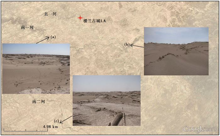
1 采样位置与地貌 1.1 古河道胡杨树树皮样品罗布泊西岸的楼兰台地区发育有多条古河道,我们将分布在楼兰古城LA南北的古河道,依据距LA的距离由近及远编号,南面为南一河、南二河,北面为北一河、北二河和北三河。野外考察发现常常在河道由窄变宽或拐弯后的开阔河段、下游不远处河床突然抬升变浅的河段和河床宽且深的河段有大量的胡杨树干倒卧,因此很可能是洪水从上游冲下来的漂木。但一些地方的河岸上仍有矗立的枯死胡杨,因此不排除河岸胡杨枯死后倒入河床的可能。我们在南一河和南二河选择3个倒卧胡杨密集的地点系统采集胡杨树皮样品(图 2a、2b和2c),采样点河道宽度均在百米左右,每个采样点均采集多棵胡杨树皮样品,以便具有代表性和统计意义,共30个(表 1)。
|
图 2 古河道采样点空间分布和地貌 Fig. 2 Spatial distribution of ancient river channels and location of sampling sites |
| 表 1 样品14C年代结果 Table 1 14C dating results of all samples |
罗布泊地区雅丹广泛发育,雅丹长轴走向为北偏东30°左右,但楼兰古城附近雅丹个体较为矮小,主要由较为坚硬的粘土粉砂层和松散的砂质粉砂层交互组成[43]。雅丹顶部常见芦苇残体,表明当时水文环境适宜芦苇生长,雅丹顶部正是当时的地面。芦苇是典型的水生或湿生植被,芦苇秆样品的年龄指示了楼兰地区水文条件较好的时间。采集并编号雅丹顶部芦苇根茎样品共4个(表 1)。
红柳是罗布泊地区主要的植物之一,红柳沙包是风沙受到红柳阻挡而堆积形成的。地下水位降低到一定深度时红柳开始死亡,大量红柳的存在指示了高地下水位期的存在[25, 44],其死亡年龄指示了地下水位大幅下降的时间。采集并编号红柳沙包红柳细枝样品共6个(表 1)。
1.3 古代遗址样品楼兰地区遗址保存条件均较差,但人类活动遗迹却依然明显,我们对3处遗址分别采集了相应的年代学样品5个(表 1),年龄可代表存在人类活动的时间。
楼兰东南遗址LD[45](40°30′07.3″N,89°57′29.7″E):位于楼兰古城东南约4 km的雅丹高台上。台地髙出周边约1 m,南距南一河约1 km。遗址长22~30 m,宽15~20 m,地表散落有大量陶片。平台南部的红柳枝篱笆墙残高约1 m,厚约20 cm,取红柳细枝样品,编号14Zh-Age-24。
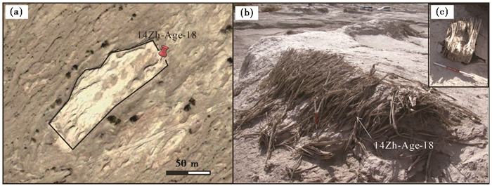
14-居址-1 (40°34′14.16″N,90°00′05.0″E;图 3):该新发现居址位于宽31~48 m,长158 m的高台地上。台地高出周边3~5 m,呈北东-南西走向。台地上分布有陶片和炉渣,样品取自东北端西北-东南走向的残留红柳墙(图 3b),取红柳细枝编号14Zh-Age-18。红柳寨墙内有一长方形深坑,深度1.0~1.5 m,周边发现有房屋木柱础(图 3c),显示此处为一处房舍遗址。
|
图 3 14-居址-1遥感影像图和野外照片 (a)居址遥感影像图;(b)红柳墙;(c)木柱础 Fig. 3 Newly discovered ancient ruin(14-JZ-1). (a)Remote sense image of the ruin; (b)The tamarisk-constructed wall; (c)Wooden foundation |
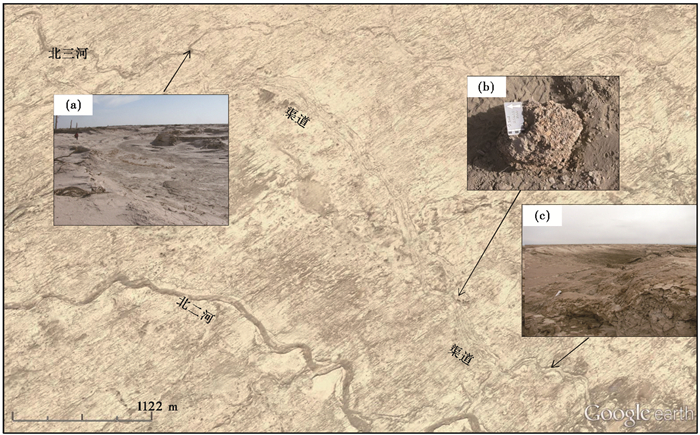
人工水渠(40°34′50.7″N,89°56′06.8″E)(图 4):新发现水渠连通北二河和北三河,自西北向东南调水。北渠首位置水渠深度1.5 m左右(图 4a),水渠具有良好的圆弧形边坡,边坡土层厚度由水道中间向外厚度增加(图 4c)。渠道边坡中存在被后期堆土覆盖的芦苇层,取芦苇样品,编号14Zh-Age-17和14Zh-Age-36。同时在渠道边坡中发现保存有红烧土角砾(图 4b),取其中炭屑样品,编号14Zh-Age-38。在渠道附近地表散落有动物骨头残片、陶片、炉渣和石器等人类活动遗迹。
|
图 4 古渠道照片 (a)北三河引水口;(b)红烧土角砾;(c)人工边坡 Fig. 4 Characteristics of ancient canals. (a)The entrance of a canal from the North River No.3; (b)The reddish brecciform sintered-clay; (c)The artificial bank of the canal |
对本次共采45个样品进行AMS 14C年代学分析。首先用超纯水洗去附着在植物表面的土壤等外来污染物,加入10 %的盐酸浸泡1 h除去附着碳酸盐,再加入1 %的NaOH溶液浸泡0.5 h除掉有机酸。倒掉过量的溶液,加入超纯水清洗多次,直到用pH试纸检测溶液呈中性。将植物样品放置在105 ℃恒温烘干箱里烘干12 h,干燥后的样品和CuO在900 ℃下燃烧2.5 h产生CO2气体[26, 46]。然后在真空系统中合成石墨,进行AMS 14C年代测定。CN系列样品的前处理在中国科学院地质与地球物理研究所宇宙成因核素年代学实验室完成,加速器质谱年代测定在北京大学完成;Beta-470213为美国BETA实验室编号,并完成测试。所有样品的14C年龄数据,利用Calib Rev 7.0.4软件进行校正[47],表 1中列出2σ的校正年龄。
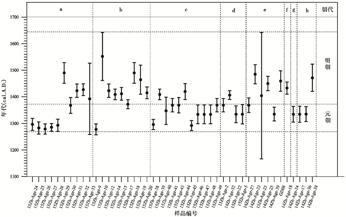
3 结果自然植物遗存样品和古代遗址样品的AMS 14C年代数据见表 1,分布在元朝-明朝早期(图 5)。
|
图 5 样品年龄分布 a~c:古河道胡杨样品,分别对应图 2a、2b和2c三处采样点;d~e:分别为雅丹区芦苇和红柳样品;f:新发现古代居址(14-居址-1);g:LD遗址;h:人工水渠 Fig. 5 14C ages of all samples. a~c:Populus euphratica specimens from ancient channels, corresponding to sampling sites in Fig. 2; d~e:Tamarix chinensis and reed ages from Yardangs area; f:14-JZ-1; g:LD ruin; h:The artificial canal |
南一河上游的样品年龄大都集中分布在元朝时期,而南一河下游样品年龄只有1个(15Zh-Age-9)分布在元朝,其他均分布在明朝早期。南二河中游样品和芦苇样品年龄分布在元末至明初。红柳样品15Zh-Age-23的年龄数据为1167~1642 cal. A. D.,跨度较大;其他4个样品中14Zh-Age-39和14Zh-Age-27分布在元朝晚期,14Zh-Age-23、14Zh-Age-25和GD08分布在明朝早期。
人工水渠人工边坡堆土下芦苇层的年龄分别为1304~1365 cal. A. D.(14Zh-Age-17)和1307~1363 cal. A.D.(14Zh-Age-36),对应元朝中晚期。红烧土角砾中炭屑的年龄为1420~1523 cal. A. D.(14Zh-Age-38),晚于芦苇层的年龄,对应明朝早期。楼兰东南房舍和新发现古人居址的城墙红柳枝年代分别为1305~1364 cal. A.D.和1410~1456 cal. A. D.,分别对应元朝晚期和明朝早期。
4 讨论 4.1 1260~1450 cal. A.D.期间楼兰古绿洲格局绿洲是干旱区特有的地理单元,水文条件的好坏是决定绿洲演化方向和人类活动的先决条件[17, 48~53]。按绿洲形成的历史可划分为古绿洲、旧绿洲和新绿洲[48],已知汉晋时期是楼兰地区历史时期的古绿洲期[30~31],其他时段的古绿洲知之甚少。
由于胡杨树皮(野外胡杨树干最外层)样品年龄代表胡杨树的最后生长时间,可以指示胡杨的大致死亡时间。如果是上游的胡杨树被洪水带到下游形成漂木,那么漂木的最后生长时间就大致指示了洪水发生的时间(或死亡时间)。同一次洪水中的漂木大致同时死亡,因此死亡年龄相对集中,统计上会出现树木死亡年龄峰值。而因为区域水文环境变差逐渐枯死的河道两岸的胡杨树,由于个体的差异先后死亡,表现为树木死亡年龄数据较分散。
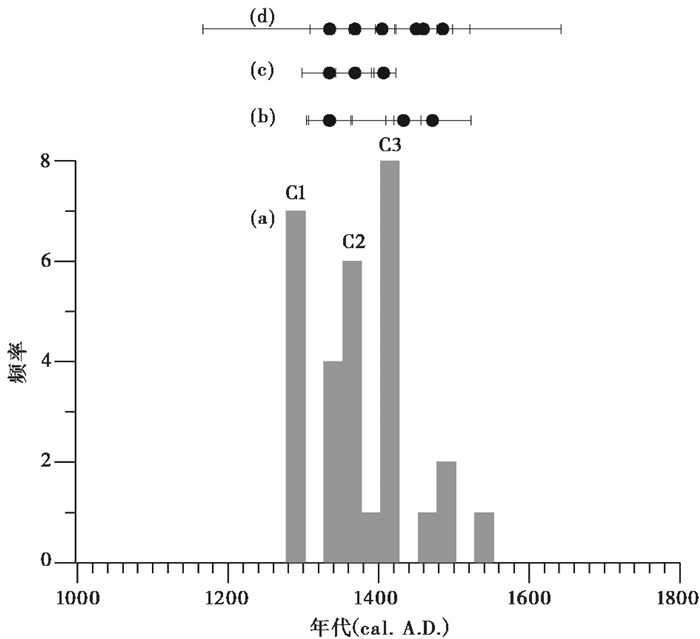
古河床胡杨树树皮样品的统计频率高峰期表示样品死亡时间较集中,对应样品是洪水带来的漂木。从表 1样品的14C年龄看出古河道样品的测年误差多数在25 a左右,于是按25 a间隔对古河道胡杨树树皮样品年龄分布进行频率统计,分布在一个间隔里的年龄数据可认为样品的最后生长时间大致相同。统计结果显示在1260~1450 cal. A. D.期间,出现3次高峰期;1450~1550 cal. A. D.样品年龄较少,而且分布较分散(图 6)。
|
图 6 古河道胡杨样品年龄分布频率和其他样品年龄分布 a—古河道胡杨样品年龄分布;b—古代人类遗址样品年龄;c—芦苇年龄数据;d—红柳样品年龄 Fig. 6 Statistic frequency of Populus euphratica samples' age and correlation of other sample ages. a—Statistic frequency of Populus euphratica samples' age; b—Ages of archeological sites; c—Ages of reed specimens; d—Ages of tamarisk specimens |
1260~1450 cal. A. D.期间的3次高峰期表明,期间存在至少3次洪水期(C1、C2和C3),每个洪水期可能包含多次洪水事件(图 6),其中C2洪水期可能持续时间较长。南一河上、下游和南二河胡杨树的年龄差异(图 5)表明1260~1450 cal. A. D.期间存在多次不同强度的洪水事件。雅丹顶部的芦苇秆的年龄与红柳年龄均出现在洪水事件结束后,表明在洪水事件(期)的间隔时期出现了地下水位较低的干旱状态。考虑到胡杨的生长时间,湿润期开始时间可能会更早一些。但因缺少胡杨生长地信息,因此只能根据胡杨漂木的死亡年龄指示的洪水期与芦苇、红柳的年龄数据,确定1260~1450cal. A.D.是罗布泊(楼兰)地区的绿洲湿润期。沿地表河流生长的胡杨林、红柳灌丛和芦苇等草甸植被构成干旱区所特有的绿洲植被景观。
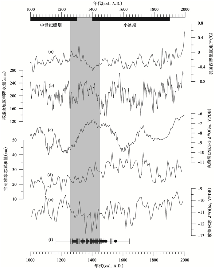
4.2 元明时期人类活动与气候变化的关系1260~1450 cal. A.D.处于中世纪暖期(1000~1300 A.D.)向小冰期(1400~1900 A.D.)转变的过渡阶段[54],区域温度逐渐降低(图 7a和7e)[55~57]。此时段在高纬度地区出现冰川扩张,因此也称早小冰期(early Little Ice Age)[58~60]。
|
图 7 元明时期楼兰地区古绿洲、人类活动和区域古环境对应关系 (a)我国西部温度距平重建曲线[56];(b)青藏高原东北部树轮古气候记录[63];(c)新疆克桑洞CNKS-3石笋记录[33];(d)古里雅冰芯冰雪累积量[61~62];(e)敦德冰芯δ18O[57];(f)本研究的14C年龄点 灰色阴影区的年代范围为1260~1450 cal. A.D. Fig. 7 Relations between climate and human activity in the Loulan area during Yuan-Ming Dynasties. (a)Reconstructed western Chinese temperature anomalies[56], (b)Tree ring record from the northeastern Tibetan Plateau[63], (c)The Kesang cave CNKS-3 stalagmite δ18O[33], Xinjiang, (d)Ice and snow accumulation of the Guliya ice core[61~62], (e)δ18O of Dunde ice core[57], (f)14C ages in this paper. Grey vertical bar denotes the range between 1260~1450 cal. A.D. |
罗布泊地区北靠天山山脉,南临阿尔金山和昆仑山山脉,其水文变化主要受控于高山降水或冰雪融水。昆仑山区是塔里木河重要的水源区,古里雅冰芯冰雪累积量的变化可作为指示昆仑山区降水量变化的有效指标,在这一时期的冰雪累积量不断增加,表明昆仑山区的降水量在不断增加[61~62](图 7d)。新疆克桑洞石笋记录(图 7c)和祁连山地区树轮的证据(图 7b)均显示此时段降水量明显增加[33, 63],艾比湖、巴里坤湖和Karakul湖古气候重建的结果表明1260~1450 cal. A.D.时期区域环境湿润[64~66]。
元明时期中原地区与西域有着频繁交流[67~72],在塔里木南缘东西向交通线以及河西走廊地区均存在这一时期的遗址[73~77]。楼兰地区人类活动和气候变化关系的研究多集中在青铜时期(小河-古墓沟)和汉晋(楼兰)时期[26, 30, 78~80],元明时期的人类活动系首次发现。新发现的古代人类居址和人工水渠表明元明时期有人在此居住并修建水渠调水灌溉。卫星影像图显示在水渠的东段存在具有规则形状的暗红色耕地[30~31]。新发现的居址、水渠和耕地,说明元明时期楼兰地区应存在一定规模、有组织的农业耕作活动,但这一时期的人类活动完全没有相关的历史记载,但此时段的人类活动和气候记录具有很好的耦合关系。因此,气候变化导致山地降水增加或区域湿度增加使1260~1450 cal. A.D.期间罗布泊地区出现适宜人类活动的绿洲环境是导致元明时期人类再次定居楼兰地区的主要原因。
13世纪是欧亚大陆历史的一段重要时期,成吉思汗及其后代带领的蒙古帝国分别于1219~1225 A.D.、1235~1241 A.D.和1252~1258 A.D.在欧亚大陆进行了3次规模空前的西征[32, 81]。罗布泊地区为欧亚干旱核心区,元明时期的湿润期意味着塔里木盆地乃至整个中亚干旱区都会出现利于绿洲发育的湿润环境[32]。考虑到楼兰地区河床内出现的漂木的生长期需至少几十年,因此塔里木盆地的湿润期应比1260 A.D.早约几十年[32],正覆盖了西征的时间。这表明中亚干旱区此时段绿洲环境的大范围发育,不仅促使蒙古帝国兵强马壮,而且为大军西征沿途提供了足够的物质基础。因此,这一时期中亚地区的湿润环境应该是蒙古国西征的重要环境因素之一。
5 结论罗布泊(楼兰)地区是古代中国与西方文化交流的重要通道,在古代丝绸之路上具有重要地位。自然环境的荒漠化与楼兰古国的消亡,使之成为干旱区气候变化-绿洲演化-人类活动关系研究的热点区域。本文在大规模野外实地考察的基础上,通过对罗布泊地区古河道中大量胡杨残体、雅丹区芦苇和红柳遗存以及多处古代遗址共45个样品的精确AMS 14C定年和统计分析,探讨了元明时期罗布泊(楼兰)地区的绿洲环境,并结合高分辨率古气候记录分析环境变化与人类活动之间的关系。
结果揭示,1)罗布泊地区自古楼兰消亡(约600 A.D.)之后,环境并非一直雅丹荒漠化,大约1260~1450 cal. A.D.是罗布泊地区的又一次湿润期,生长大量的绿洲植被。湿润期包含多次洪水事件,表现为洪水期与枯水期的脉冲式交替出现。2)古代人类居址和人工水渠的年代结果显示在元明时期楼兰地区存在一定规模的人类活动,并修渠调水灌溉农田,但未发现其他具有指示性意义的墓葬遗址或器物。3)气候变化导致的洪水使楼兰地区再次出现绿洲化,区域水文条件变好是导致元明时期人类再次定居楼兰地区的主要因素。13世纪中亚干旱区相对湿润的绿洲环境,应该是蒙古国西征的重要环境因素之一。
致谢: 感谢杨美芳老师和审稿专家的宝贵意见,感谢若羌县文物局楼兰文物保护站崔有生同志在野外采样上的帮助。
| [1] |
Zhang P, Cheng H, Edwards R L et al. A test of climate, sun, and culture relationships from an 1810-year Chinese cave record. Science, 2008, 322(5903): 940-942. DOI:10.1126/science.1163965 |
| [2] |
Buckley B M, Anchukaitis K J, Penny D et al. Climate as a contributing factor in the demise of Angkor, Cambodia. Proceedings of National Academy of Sciences of the United States of America, 2010, 107(15): 6748-6752. DOI:10.1073/pnas.0910827107 |
| [3] |
Büntgen U, Tegel W, Nicolussi K et al. 2500 years of European climate variability and human susceptibility. Science, 2011, 331(6017): 578. DOI:10.1126/science.1197175 |
| [4] |
Büntgen U, Cosmo N Di. Climatic and environmental aspects of the Mongol withdrawal from Hungary in 1242 CE. Scientific Reports, 2016, 6: 25606. DOI:10.1038/srep25606 |
| [5] |
Pederson N, Hessl A E, Baatarbileg N et al. Pluvials, droughts, the Mongol Empire, and modern Mongolia. Proceedings of National Academy of Sciences of the United States of America, 2014, 111(12): 4375-4379. DOI:10.1073/pnas.1318677111 |
| [6] |
Dong G, Ren L, Jia X et al. Chronology and subsistence strategy of Nuomuhong Culture in the Tibetan Plateau. Quaternary International, 2016, 426: 42-49. DOI:10.1016/j.quaint.2016.02.031 |
| [7] |
Dong G, Yang Y, Zhao Y et al. Human settlement and human-environment interactions during the historical period in Zhuanglang County, western Loess Plateau, China. Quaternary International, 2012, 281(1): 78-83. |
| [8] |
Jia X, Lee H F, Zhang W et al. Human-environment interactions within the West Liao River basin in Northeastern China during the Holocene Optimum. Quaternary International, 2016, 426: 10-17. DOI:10.1016/j.quaint.2016.01.011 |
| [9] |
Kawahata H, Matsuoka M, Togami A et al. Climatic change and its influence on human society in western Japan during the Holocene. Quaternary International, 2017, 440(Part A): 102-117. |
| [10] |
韩鹏, 刘兴起. 内蒙古中东部查干淖尔湖流域7000年以来的气候演变. 第四纪研究, 2017, 37(6): 1381-1390. Han Peng, Liu Xingqi. The climate evolution inferred from Chagan-Nuur in middle-east part of Inner Mongolia since the last 7000 years. Quaternary Sciences, 2017, 37(6): 1381-1390. |
| [11] |
郭超, 马玉贞, 刘杰瑞等. 过去2000年来西藏羊卓雍错沉积物粒度记录的气候变化. 第四纪研究, 2016, 36(2): 405-419. Guo Chao, Ma Yuzhen, Liu Jierui et al. Climatic change recorded by grain-size in the past about 2000 years from Yamzhog Yumco Lake, Tibet. Quaternary Sciences, 2016, 36(2): 405-419. |
| [12] |
倪振宇, 王永波, 刘兴起. 青藏高原北部库赛湖自生碳酸盐稳定同位素记录的晚全新世气候组合特征. 第四纪研究, 2016, 36(4): 961-969. Ni Zhenyu, Wang Yongbo, Liu Xingqi. Late Holocene climatic combination on the northern Tibetan Plateau based on stable isotope analysis of authigenic carbonate from Kusai Lake. Quaternary Sciences, 2016, 36(4): 961-969. |
| [13] |
蒋文静, 赵侃, 陈仕涛等. 小冰期十年际尺度亚洲季风变化的四川黑竹沟洞石笋记录. 第四纪研究, 2017, 37(1): 118-129. Jiang Wenjing, Zhao Kan, Chen Shitao et al. Decadal climate oscillations during the Little Ice Age of stalagmite record from Heizhugou cave, Sichuan. Quaternary Sciences, 2017, 37(1): 118-129. |
| [14] |
Yang X. The oases along the Keriya River in the Taklamakan Desert, China, and their evolution since the end of the last glaciation. Environmental Geology, 2001, 41(3-4): 314-320. DOI:10.1007/s002540100388 |
| [15] |
Miao L L, Cai W B, Wang A M. On evolution of man-land system in oasis. Chinese Geographical Science, 2002, 12(3): 199-205. DOI:10.1007/s11769-002-0002-3 |
| [16] |
Zu R, Gao Q, Qu J et al. Environmental changes of oases at southern margin of Tarim Basin, China. Environmental Geology, 2003, 44(6): 639-644. DOI:10.1007/s00254-003-0808-z |
| [17] |
Xie Y, Chen F, Qi J. Past desertification processes of Minqin Oasis in arid China. International Journal of Sustainable Development & World Ecology, 2009, 16(4): 260-269. |
| [18] |
Liu B, Zhao W, Chang X et al. Water requirements and stability of oasis ecosystem in arid region, China. Environmental Earth Sciences, 2009, 59(6): 1235-1244. |
| [19] |
Zhao K, Li X, Zhou X et al. Impact of agriculture on an oasis landscape during the Late Holocene:Palynological evidence from the Xintala site in Xinjiang, NW China. Quaternary International, 2013, 311(311): 81-86. |
| [20] |
Song W, Zhang Y. Expansion of agricultural oasis in the Heihe River basin of China:Patterns, reasons and policy implications. Physics and Chemistry of the Earth, Parts A/B/C, 2015, 89-90: 46-55. DOI:10.1016/j.pce.2015.08.006 |
| [21] |
王守春. 楼兰国都与古代罗布泊的历史地位. 西域研究, 1996(4): 43-53. Wang Shouchun. The historical status of Loulan city and Lop Nur. The Western Regions Studies, 1996(4): 43-53. |
| [22] |
Luo Chao, Peng Zicheng, Yang Dong et al. A lacustrine record from Lop Nur, Xinjiang, China:Implications for paleoclimate change during Late Pleistocene. Journal of Asian Earth Sciences, 2009, 34(1): 38-45. DOI:10.1016/j.jseaes.2008.03.011 |
| [23] |
Jia H, Wang J, Qin X et al. Palynological implications for Late Glacial to Middle Holocene vegetation and environmental history of the Lop Nur Xinjiang Uygur Autonomous Region, Northwestern China. Quaternary International, 2017, 436(Part A): 162-169. |
| [24] |
Dong Z, Lv P, Qian G et al. Research progress in China's Lop Nur. Earth-Science Reviews, 2012, 111(1-2): 142-153. DOI:10.1016/j.earscirev.2011.11.003 |
| [25] |
夏训诚, 王富葆, 赵元杰. 中国罗布泊. 北京: 科学出版社, 2007: 1-469. Xia Xuncheng, Wang Fubao, Zhao Yuanjie. Lop Nur of China. Beijing: Science Press, 2007: 1-469. |
| [26] |
Xu B, Gu Z, Qin X et al. Radiocarbon dating the ancient city of Loulan. Radiocarbon, 2017, 59(4): 1-12. |
| [27] |
陈宗器. 罗布淖尔与罗布荒漠. 地理学报, 1936, 3(1): 1-30. Chen Zongqi. Lop Nur Lake and Lop desert. Acta Geographica Sinica, 1936, 3(1): 1-30. |
| [28] |
Hedin S(1926). My Life as An Explorer[M]. New Delhi: AES, 1998: 1-544.
|
| [29] |
Huntington E. The pulse of Asia. Geographical Review, 1907(3): 347-373. |
| [30] |
Qin X, Liu J, Jia H et al. New evidence of agricultural activity and environmental change associated with the ancient Loulan kingdom, China, around 1500 years ago. The Holocene, 2011, 22(1): 53-61. |
| [31] |
Zhang J, Lu H, Wu N et al. Palaeoenvironment and agriculture of ancient Loulan and Milan on the Silk Road. The Holocene, 2012, 23(2): 208-217. |
| [32] |
Putnam A E, Putnam D E, Andreu-Hayles L et al. Little Ice Age wetting of interior Asian deserts and the rise of the Mongol Empire. Quaternary Science Reviews, 2016, 131(1): 33-50. |
| [33] |
Cai Y J, Chiang C H, Breitenbach S F M et al. Holocene moisture changes in Western China, Central Asia, inferred from stalagmites. Quaternary Science Reviews, 2017, 158: 15-28. DOI:10.1016/j.quascirev.2016.12.014 |
| [34] |
Lü H, Xia X, Liu J et al. A preliminary study of chronology for a newly-discovered ancient city and five archaeological sites in Lop Nor, China. Chinese Science Bulletin, 2009, 55(1): 63-71. |
| [35] |
司马迁(91BC). 史记[M]. 文天译注. 北京: 中华书局, 2016: 1-450. Sima Qian(91BC). Shi Ji[M]. Annotation by Wen Tian. Beijing: Zhonghua Book Company, 2016: 1-450. |
| [36] |
班固(92). 汉书[M]. 张永雷, 刘丛注释. 北京: 中华书局, 2016: 1-340. Ban Gu(92). Han Shu[M]. Annotation by Zhang Yonglei and Liu Cong. Beijing: Zhonghua Book Company, 2016: 1-340. |
| [37] |
韩春鲜, 熊黑钢, 张冠斌. 罗布地区人类活动与环境变迁. 中国历史地理论丛, 2003, 18(3): 38-45. Han Chunxian, Xiong Heigang, Zhang Guanbin. Human activities and environmental evolution in the Lop region. Collections of Essays on Chinese Historical Geography, 2003, 18(3): 38-45. |
| [38] |
韩春鲜, 吕光辉. 清代以来塔里木盆地东部罗布人的生活及其环境变化. 中国历史地理论丛, 2006, 21(2): 60-66. Han Chunxian, Lü Guanghui. The changes of Lopliks living in the east of the Tarim Basin and their environment since the Qing Dynasty. Collections of Essays on Chinese Historical Geography, 2006, 21(2): 60-66. |
| [39] |
Liu C, Zhang J, Jiao P et al. The Holocene history of Lop Nur and its palaeoclimate implications. Quaternary Science Reviews, 2016, 148: 163-175. DOI:10.1016/j.quascirev.2016.07.016 |
| [40] |
Yang D, Peng Z, Luo C et al. High-resolution pollen sequence from Lop Nur, Xinjiang, China:Implications on environmental changes during the Late Pleistocene to the Early Holocene. Review of Palaeobotany and Palynology, 2013, 192(192): 32-41. |
| [41] |
Wang J Z, Jia H J. Sediment record of environmental change at Lake Lop Nur(Xinjiang, NW China) from 13.0 to 5.6 cal ka BP. Chinese Journal of Oceanology and Limnology, 2016, 35(5): 1070-1078. |
| [42] |
贾红娟, 汪敬忠, 秦小光等. 罗布泊地区晚冰期至中全新世气候特征及气候波动事件. 第四纪研究, 2017, 37(3): 510-521. Jia Hongjuan, Wang Jingzhong, Qin Xiaoguang et al. Climate and abrupt events recorded in the Lop Nur region from Late Glacial to the Middle Holocene. Quaternary Sciences, 2017, 37(3): 510-521. |
| [43] |
林永崇, 穆桂金, 秦小光等. 新疆楼兰地区雅丹地貌差异性侵蚀特征. 中国沙漠, 2017, 37(1): 33-39. Lin Yongchong, Mu Guijin, Qin Xiaoguang et al. Erosion characteristics of Yardangs at Loulan area, Xinjiang, China. Journal of Desert Research, 2017, 37(1): 33-39. DOI:10.7522/j.issn.1000-694X.2015.00214 |
| [44] |
Gries D, Zeng F, Foetzki A et al. Growth and water relations of Tamarix ramosissima and Populus euphratica on Taklamakan Desert dunes in relation to depth to a permanent water table. Plant Cell & Environment, 2003, 26(5): 725-736. |
| [45] |
Stein M A, Andrews F H. Serindia:Detailed report of explorations in Central Asia and westernmost China. Veterinary Surgery, 1921, 44(5): 328-332. |
| [46] |
Getachew G, Kim S-H, Burri B J et al. How to convert biological carbon into graphite for AMS. Radiocarbon, 2016, 48(3): 325-336. |
| [47] |
Reimer P J, Bard E, Bayliss A et al. IntCal13 and Marine13 radiocarbon age calibration curves 0-50, 000 years cal BP. Radiocarbon, 2013, 55(4): 1869-1887. DOI:10.2458/azu_js_rc.55.16947 |
| [48] |
樊自立. 塔里木盆地绿洲形成与演变. 地理学报, 1993(5): 421-427. Fan Zili. A study on the formation and evolution of oases in Tarim Basin. Acta Geographica Sinica, 1993(5): 421-427. |
| [49] |
李并成. 河西走廊汉唐古绿洲沙漠化的调查研究. 地理学报, 1998, 53(2): 106-115. Li Bingcheng. An investigation and study on the desertification of the ancient oases from Han to Tang Dynasties in the Hexi Corridor. Acta Geographica Sinica, 1998, 53(2): 106-115. |
| [50] |
Wang G, Cheng G. Water resource development and its influence on the environment in arid areas of China——The case of the Hei River basin. Journal of Arid Environments, 1999, 43(2): 121-131. DOI:10.1006/jare.1999.0563 |
| [51] |
Zhang F, Wang T, Yimit H et al. Hydrological changes and settlement migrations in the Keriya River delta in central Tarim Basin ca. 2.7-1.6 ka BP:Inferred from 14C and OSL chronology. Science China:Earth Sciences, 2011, 54(12): 1971-1980. DOI:10.1007/s11430-011-4206-1 |
| [52] |
夏倩倩, 张峰. 塔克拉玛干沙漠腹地克里雅河尾闾圆沙三角洲AMS 14C年代学测定及相关历史地理问题刍议. 第四纪研究, 2016, 36(5): 1280-1292. Xia Qianqian, Zhang Feng. AMS 14C dating and related historical geography question proposal at the Yuansha delta in the central Taklamakan Desert. Quaternary Sciences, 2016, 36(5): 1280-1292. |
| [53] |
耿建伟, 赵晖, 王兴繁等. 历史时期额济纳盆地水系与绿洲演变过程及其机制研究. 第四纪研究, 2016, 36(5): 1204-1215. Geng Jianwei, Zhao Hui, Wang Xingfan et al. Oasis and drainage network evolution processes and mechanisms of Ejina Basin during historical period. Quaternary Sciences, 2016, 36(5): 1204-1215. |
| [54] |
Ruddiman W F. Earth's Climate Past and Future(second edition)[M]. New York: W. H. Freeman and Company, 2008: 289-308.
|
| [55] |
Yang B, Braeuning A, Johnson K R et al. General characteristics of temperature variation in China during the last two millennia. Geophysical Research Letters, 2002, 29(9): 38-31-38-34. |
| [56] |
Shi F, Yang B, Von Gunten L. Preliminary multiproxy surface air temperature field reconstruction for China over the past millennium. Science China:Earth Sciences, 2012, 55(12): 2058-2067. DOI:10.1007/s11430-012-4374-7 |
| [57] |
Thompson L G, Mosley-Thompson E, Brecher H et al. Abrupt tropical climate change:Past and present. Proceedings of National Academy of Sciences of the United States of America, 2006, 103(28): 10536-10543. DOI:10.1073/pnas.0603900103 |
| [58] |
Luckman B H. Calendar-dated, early 'Little Ice Age' glacier advance at Robson Glacier, British Columbia, Canada. The Holocene, 1995, 5(2): 149-159. DOI:10.1177/095968369500500203 |
| [59] |
Luckman B H. The Little Ice Age in the Canadian Rockies. Geomorphology, 2000, 32(3-4): 357-384. DOI:10.1016/S0169-555X(99)00104-X |
| [60] |
Barclay D J, Wiles G C, Calkin P E. Holocene glacier fluctuations in Alaska. Quaternary Science Reviews, 2009, 28(21-22): 2034-2048. DOI:10.1016/j.quascirev.2009.01.016 |
| [61] |
Thompson L G, Mosley-Thompson E, Davis M E et al. A 1000 year climate ice-core record from the Guliya ice cap, China:Its relationship to global climate variability. Annals of Glaciology, 1995, 21: 175-181. DOI:10.1017/S0260305500015780 |
| [62] |
Yao T, Jiao K, Tian L et al. Climatic variations since the Little Ice Age recorded in the Guliya Ice Core. Science in China(Series D), 1996, 39(6): 587-596. |
| [63] |
Yang B, Qin C, Wang J et al. A 3, 500-year tree-ring record of annual precipitation on the northeastern Tibetan Plateau. Proceedings of National Academy of Sciences of the United States of America, 2014, 111(8): 2903-2908. DOI:10.1073/pnas.1319238111 |
| [64] |
Mischke S, Rajabov I, Mustaeva N et al. Modern hydrology and Late Holocene history of Lake Karakul, eastern Pamirs(Tajikistan):A reconnaissance study. Palaeogeography, Palaeoclimatology, Palaeoecology, 2010, 289(1-4): 10-24. DOI:10.1016/j.palaeo.2010.02.004 |
| [65] |
Tao S, An C, Chen F et al. Pollen-inferred vegetation and environmental changes since 16.7 ka BP at Balikun Lake, Xinjiang. Chinese Science Bulletin, 2010, 55(22): 2449-2457. DOI:10.1007/s11434-010-3174-8 |
| [66] |
Wang W, Feng Z, Ran M et al. Holocene climate and vegetation changes inferred from pollen records of Lake Aibi, northern Xinjiang, China:A potential contribution to understanding of Holocene climate pattern in East-central Asia. Quaternary International, 2013, 311: 54-62. DOI:10.1016/j.quaint.2013.07.034 |
| [67] |
田卫疆, 伊第利斯·阿不都热苏勒. 新疆通史. 乌鲁木齐: 新疆美术摄影出版社, 2016: 166-200. Tian Weijiang, Yidilis Abuduresule. History of Xinjiang. Vrümqi: Xinjiang Art and Photography Press, 2016: 166-200. |
| [68] |
施新荣. 明代哈密与中原地区的经济交往——以贡赐贸易为中心. 西域研究, 2007(1): 18-27. Shi Xinrong. Economic contact between Hami and the Central Plains during the Ming Dynasty-Focusing on the exchange of tributing and granting. The Western Regions Studies, 2007(1): 18-27. |
| [69] |
王旭送. "元明时期的新疆"学术研讨会综述. 西域研究, 2011(4): 136-137. Wang Xusong. Overview of the symposium called "Xinjiang of Yuan-Ming Dynasties". The Western Regions Studies, 2011(4): 136-137. |
| [70] |
刘刚. 论察合台汗国和窝阔台汗国关系嬗变. 兰台世界, 2012(6): 11-12. Liu Gang. The changing relation between Chahetai and Wokuotai. Lantai World, 2012(6): 11-12. |
| [71] |
袁澍. 元代用人政策与西域知识分子. 新疆师范大学学报:哲学社会科学版, 1986(2): 52-58. Yuan Shu. The employment policy of Yuan Dynasty and intellectuals in the western region. Journal of Xinjiang Normal University:Philosophical and Social Science, 1986(2): 52-58. |
| [72] |
马建春. 元代西域人的商业活动. 暨南学报(哲学社会科学版), 2006, 28(3): 171-176. Ma Jianchun. The commercial activities of the people in the western region of the Yuan Dynasty. Journal of Jinan University(Philosophy and Social Sciences), 2006, 28(3): 171-176. |
| [73] |
Li H, Liu F, Cui Y et al. Human settlement and its influencing factors during the historical period in an oasis-desert transition zone of Dunhuang, Hexi Corridor, Northwest China. Quaternary International, 2017, 458: 113-122. DOI:10.1016/j.quaint.2016.11.044 |
| [74] |
Luo L, Wang X, Liu C et al. Integrated RS, GIS and GPS approaches to archaeological prospecting in the Hexi Corridor, NW China:A case study of the royal road to ancient Dunhuang. Journal of Archaeological Science, 2014, 50(1): 178-190. |
| [75] |
张平. 新疆若羌出土两件元代文书. 文物, 1987(5): 91-92. Zhang Ping. Two documents of Yuan Dynasty unearthed from Ruoqiang Country, Xinjiang. Cultural Relics, 1987(5): 91-92. |
| [76] |
袁晓红, 潜伟. 新疆若羌瓦石峡遗址出土冶金遗物的科学研究. 中国国家博物馆馆刊, 2012(2): 141-149. Yuan Xiaohong, Qian Wei. A scientific research of metallurgical remains found in Washixia. Journal of National Museum of China, 2012(2): 141-149. |
| [77] |
黄小江. 若羌县文物调查简况(上). 新疆文物, 1985(1): 20-25. Huang Xiaojiang. A brief description of the cultural relics investigation of Ruoqiang County. The Cultural Relics of Xinjiang, 1985(1): 20-25. |
| [78] |
Qiu Z, Yang Y, Shang X et al. Paleo-environment and paleo-diet inferred from Early Bronze Age cow dung at Xiaohe Cemetery, Xinjiang, NW China. Quaternary International, 2014, 349: 167-177. DOI:10.1016/j.quaint.2014.03.029 |
| [79] |
Mischke S, Liu C, Zhang J et al. The world's earliest Aral-Sea type disaster:The decline of the Loulan Kingdom in the Tarim Basin. Scientific Reports, 2017, 7: 43102. DOI:10.1038/srep43102 |
| [80] |
Zhang Y, Mo D, Hu K et al. Holocene environmental changes around Xiaohe Cemetery and its effects on human occupation, Xinjiang, China. Journal of Geographical Sciences, 2017, 27(6): 752-768. DOI:10.1007/s11442-017-1404-6 |
| [81] |
吴文祥, 葛全胜, 郑景云等. 气候变化因素在蒙古西征中的可能作用研究. 第四纪研究, 2009, 29(4): 724-732. Wu Wenxiang, Ge Quansheng, Zheng Jingyun et al. Possible role of climate change in the Mongol westward conquests. Quaternary Sciences, 2009, 29(4): 724-732. |
2 University of Chinese Academy of Science, Beijing 100049;
3 Xinjiang Institute of Ecology and Geography, Chinese Academy of Sciences, Vrümqi 830011, Xinjiang;
4 Jilin University, Changchun 130012, Jilin;
5 Xinjiang Institute of Archaeology, Vrümqi 830011, Xinjiang;
6 Hebei GEO University, Shijiazhuang 050031, Hebei;
7 Bureau of Cultural Heritage of Ruoqiang County, Ruoqiang 841800, Xinjiang)
Abstract
The oasis evolution and human activity strongly related to hydrological conditions in Tarim Basin, Xinjiang, China, in historic time. The Lop Nur(Loulan) region, southern Xinjiang, was the terminal lake of the Tarim River and the famous ancient Loulan kingdom located on the west bank of the Lake Lop Nur. However, the area has been experienced dramatic changes from oasis to wasteland. In this paper, we conducted systematical radiocarbon dating(AMS 14C) with 30 specimens of subfossil Populus euphratica lying on ancient riverbeds, which may be driftwoods transported by floods or be dead trees grew on both sides of the river, 10 specimens of Tamarix chinensis and reed in Yardang area between ancient rivers, and 5 specimens sampled from three archaeological sites(two settlements and an artificial canal). The statistical characteristics of 14C ages were also analyzed. Finally by compared with historical documents and reported palaeoclimatic records, the relation between oasis environment and human activity was discussed. Results show good consistency between natural plant remains and archaeological sites, corresponding with the Yuan-Ming Dynasty(1271~1644 A.D.). It was found that the difference on age distribution of two aforementioned sources of subfossil P. euphratica is obvious. The presence of three age peaks of P. euphratica, corresponding with our driftwood samples, implies that the Loulan area experienced at least three flood events and re-experienced oasis environment from 1260 cal. A.D. to 1450 cal. A.D., which is the climate transition stage from the Medieval Warm Period to the Little Ice Age. Specifically, results show that reed and tamarisk samples appear to be dated to the end of flood events, indicating a decrease in groundwater level during intermittent periods. Therefore, it is concluded that several pulse-like flood event-featured wet-dry alternative cycles constitute the wet period. In the meantime, human re-settled in the Loulan area and built canals to irrigate farmlands. Buried reed layers were found on the artificial bank because the people who lived in the Loulan area at this time dredged the canal and placed sediments directly onto growing reeds in the banks of the canal during the flooding periods. The presence of reddish sintered-clay breccia in the artificial bank can also be interpreted as evidence of human activity at this time, which may be related to people maintaining the canal after flooding events. By compared with high-resolution palaeoclimatic records(ice core, tree ring, and stalagmite) from Kunlun Mountains, Qilian Mountains, and Tianshan Mountains, around Tarim Basin, it was believed that human resettlement in the area during the Yuan-Ming Dynasties was primarily dominated by an increase in runoff resulted from mountain precipitation. Furthermore, Lop Nur region is the core arid area of Eurasia, the enlargement of Loulan oasis strongly suggests the wet climate and a prosperous oasis environment in the whole central Asia, that may be a major environmental factor for the three times of Mongol westward conquest in 13th century. 2018, Vol.38

