2 西安交通大学, 全球环境变化研究院, 陕西 西安 710049;
3 杜伦大学地理系, 杜伦 DH1 3LE, 英国;
4 南加州大学地球科学系, 洛杉矶, CA 90089 美国)
构造活动对地球表面地形地貌的形成具有重要的作用,一方面通过板块碰撞隆升山脉,另一方面却又通过构造应力作用将岩石破裂为易剥蚀搬运的碎块,加速剥蚀移平作用[1~2];这两个过程的竞争制约着造山带的演化和地表物质的循环[3~6]。在发生地壳形变的区域,特别是构造活动活跃的造山带,地震频发。大地震的强震动往往造成大量的岩石崩塌、滑坡[7~10]。这些滑坡物质易输送进入河流,增加年际尺度的流域剥蚀速率[3~4, 7, 10~13],造成山脉质量亏损。在全球尺度上,地震造成的滑坡数量和体积与震级还存在较好的相关性[6~7, 14]。在增加山脉剥蚀的同时,地震产生的滑坡会加速化学风化与有机碳输移,进而影响碳循环。已有的研究表明,地震滑坡往往造成新鲜岩石的暴露,加速岩石的化学风化[15~18]。滑坡也导致大量森林植被的破坏和颗粒有机碳(POC)的剥蚀[19~21],但是对这些有机质的归宿(氧化还是埋藏)还缺乏深入的认识[22~23]。这类事件所造成的剥蚀和风化通量比正常情形下要高几倍,乃至一个数量级,且影响时间可持续几年至数百年[13, 24]。然而,由于高强度构造突发事件具有偶然性、极低的发生频次(复发周期通常大于百年),加之往往缺乏事件之前的样品或数据,因此由这些重大事件引发的流域剥蚀和风化过程和通量变化还所知甚少,与之相关的碳收支也是目前全球碳循环研究和气候变化模型中最不确定的部分。
发生在青藏高原东缘的2008年汶川特大地震及其造成的大面积滑坡为评价巨大的、罕见的地质构造事件对地表剥蚀、风化和有机碳输移的影响提供了一次非常珍贵的自然实验场[25~26],特别是对于岷江流域[13, 27~30]。该地震除了因为震级高、伤亡大而举世瞩目外,其核心区所处的青藏高原东缘龙门山构造带是地球科学的热门关注区域之一;该构造带以构造活动强烈和剥蚀速率高而著称,前人对该流域构造运动、地表剥蚀-风化均有大量的报道[31~35]。地震发生后,前人开展了有关地震成因、造山变形、滑坡、地质灾害等方面的研究[3, 36~38]。然而,就该地震事件对流域剥蚀风化影响则较为缺乏,认识也还十分有限。例如地震产生的滑坡对河流输移和风化通量的影响到底有多大?它们的输移受什么因素控制?巨量的滑坡物质产生沉积物的机制和速率以及最终如何被河流系统转运出去?地震造成的滑坡剥蚀的POC归宿如何?将对流域造成多长时间的影响?这些问题均缺乏基本的认识和了解。
本文通过2008年汶川MW7.9级特大地震引发的滑坡分布的评估,对比研究地震前后流域剥蚀-风化和有机碳输移通量的变化,揭示类似汶川地震之类的构造活动对流域剥蚀-风化及有机碳输移过程的影响强度、幅度和持续时间;并结合2013年芦山6.6级地震的滑坡分布,提出地震滑坡是长时间尺度流域剥蚀的主控因子。这将有助于加深我们对青藏高原隆升对地表剥蚀和风化制约以及地质时间尺度上的构造与全球气候变化关系的认识。
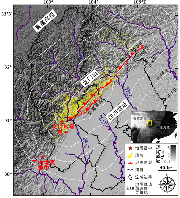
1 地震滑坡分布与剥蚀通量2008年5月12日的汶川特大地震发生于青藏高原东缘的龙门山断裂带。该断裂带东北走向,为青藏高原与四川盆地的过渡山区,长约500 km,宽约30 km,由一系列右行逆冲、斜向滑动断裂构成[39~41]。龙门山地势陡峭、高程落差巨大,海拔从500 m的四川盆地在30~50 km距离内上升到4000~5000 m,最高山峰达到6000 m,局部地形坡度超过10 % [31],表现为强烈的侵蚀切割型高山峡谷,为地球上最陡峭的构造活动区之一[40~42]。2008年汶川地震产生了近6万个滑坡,主要分布于发源自龙门山的长江一级支流岷江、沱江和二级支流涪江流域[5, 43],总体积达3 km3[5],大多数滑坡物质至今还停留在震区的山坡和谷地(图 1)。发生于2013年4月20日的雅安芦山6.6级地震离汶川地震震中以南约80 km,位于龙门山南边(图 1)。与汶川地震类似,芦山地震造成了总面积达18.88 km2的2万多个山体滑坡,滑坡总体积为0.042 km3[44]。
|
图 1 研究区域地形地貌图 包括汶川地震断裂带、峰值加速度(PGA)等值线(来自USGS,http://earthquake.usgs.gov/earthquakes)及其引发的滑坡、2008年汶川地震与2013年芦山地震震中位置、龙门山与主要流域(岷江、沱江、涪江)以及研究区域位置图;芦山地震引发的滑坡体积约为汶川滑坡体积的1 %~2 % [5, 44](未在图中展示) Fig. 1 Map of the study area, including topography, fault trace, peak ground acceleration(PGA)contours(from U.S. Geological Survey Earthquake Hazards Program, http://earthquake.usgs.gov/earthquakes)of the Wenchuan earthquake, the Wenchuan earthquake-triggered landslides(yellow polygon), the epicenters of the 2008 MW7.9 Wenchuan and the 2013 MW6.6 Lushan earthquakes, the Longmen Shan Mountains and the main fluvial systems draining the Longmen Shan (the Minjiang River, the Tuojiang River and the Fujiang River catchments). The total volume of the Lushan earthquake-triggered landslides(not shown)was 1 %~2 % of that of the Wenchuan earthquake-triggered landslides[5, 44] |
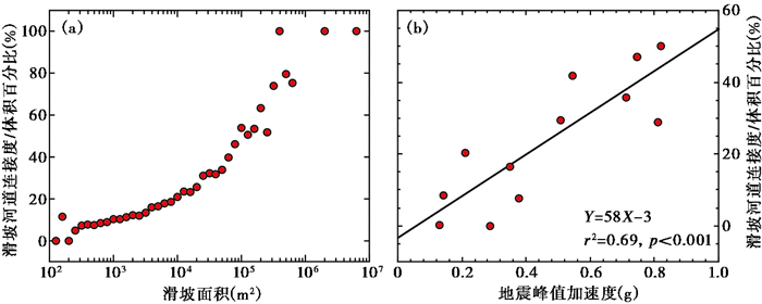
要评估地震滑坡与剥蚀作用的关系,首先需要获得滑坡的空间分布、面积及体积,它们关系到滑坡物质能否顺利输移到河道中以及需要多长时间被清空。本研究利用遥感图像绘编的汶川地震引发的滑坡数据集[5],并根据滑坡面积-体积的经验关系估算了滑坡体积。由汶川地震产生的近6万个滑坡中,大约总个数的16 %、总面积的30 %和总体积43 % (约1.4 km3)的滑坡直接与流域河道相连接,剩余的占总体积57 % (约1.6 km3)的滑坡没有直接与河道相连接而是位于山坡上[30]。滑坡与河道的连接度主要受到单个滑坡体大小以及滑坡区域的地震峰值加速度的控制(图 2)。在地震峰值加速度较大的区域,产生的滑坡体尺寸也较大,也更容易连接到河道。
|
图 2 (a) 滑坡面积与滑坡-河道连接度关系和(b)地震峰值加速度与滑坡-河道连接度关系 (b)中横坐标单位“g”是加速度的一个度量单位,代表一个标准重力加速度值,数值上为9.8 m/s2 Fig. 2 Relationships between landslide-channel connectivity plotted vs. (a)landslide area triggered by the Wenchuan earthquake and (b) peak ground accelerations. The unit of the x-axis in (b), g, means the standard gravitational acceleration with a value of 9.8 m/s2, and is used here as a metric of the peak ground acceleration |
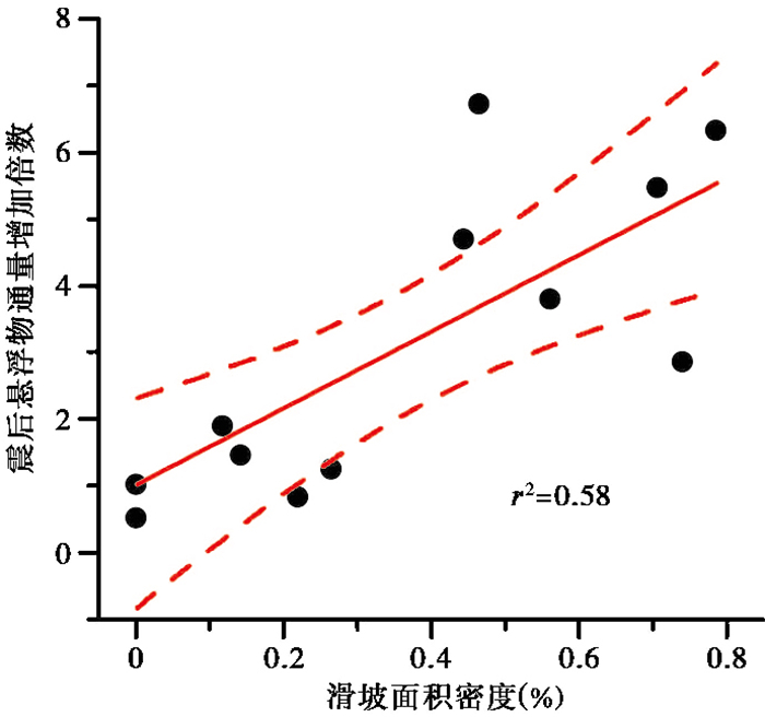
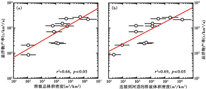
流域的物理剥蚀通量则由河流悬浮物通量与推移质通量组成。河流悬浮物通量可以通过径流量和悬浮物含量计算得到[45~46]。然而,要获得地震滑坡对流域物理剥蚀通量的贡献,需要扣除河流悬浮物背景值,即没有地震发生时河流悬浮物通量[47]。只有扣除了背景值之后,增加的悬浮物通量才是地震对流域物理剥蚀通量的贡献。地震发生之前的河流悬浮物通量常常用来作为背景值扣除[47],尽管在地震频发的构造活跃带,这次地震之前的悬浮物通量很可能还保留着上一次地震的滑坡记忆。但由于缺乏地震前后逐日悬浮物浓度数据,以前的研究主要是通过部分监测的径流量和悬浮物浓度之间的非线性关系的变化分析地震对流域剥蚀影响[47]。通过对龙门山地区三大河流(岷江、沱江和涪江)16个水文站点2008年汶川地震前后(2006~2012年)逐日径流量和悬浮物通量比较,更直接地评估了地震对流域剥蚀的影响[13]。结果表明,相对于地震前,3条河流的输沙量增加了3至7倍[13]。由于2008年汶川地震前后,该地区的水文和降水模式并没有发生显著变化,因此地震后悬浮物通量的增加是地震造成的直接结果。2008年汶川地震后3条河流12个站点的悬浮物增加的倍数与滑坡面积密度之间呈正相关关系(图 3),各个小流域的悬浮物通量与总滑坡体积也有较好的相关性(图 4a),进一步证实了地震滑坡的确增加了流域剥蚀通量。
|
图 3 2008年汶川地震后龙门山地区三大河流(岷江、沱江和涪江)悬浮物增加的倍数与滑坡密度之间的正相关关系 横坐标为每个流域内滑坡面积与流域面积的比值(%),纵坐标为地震后(2008~2012年)与地震前(2006~2007年)年均悬浮物通量增加的倍数;实线为线性拟合,虚线表示95 %的置信区间 Fig. 3 A positive relationship between earthquake-triggered landslide area density and the increased times of suspended sediment for each catchment of three major rivers(the Minjiang River, the Fujiang River, and the Tuojiang River)draining the Longmen Shan after the 2008 Wenchuan earthquake. The x-axis is percentage of landslide area to catchment area and the y-axis is increased times of suspended sediment after the earthquake(2008~2012)relative to that before the earthquake(2006~2007). The solid line shows best fit from linear regression and the dashed lines show the 95 % confidence bands of the fit |
|
图 4 汶川地震后河流悬浮物产率与流域面积均一化的滑坡总体积(a)和连接到河道的滑坡体积关系(b) 悬浮物数据来自龙门山地区16个水文站[13] Fig. 4 Relationships between suspended sediment yield over 2009~2012 after the Wenchuan earthquake plotted vs. (a)catchment area-normalized total landslide volumetric density and (b)catchment area-normalized channel-connected landslide volumetric density for each catchment. The suspended sediment concentration data from 16 hydrological stations across the Longmen Shan are after reference[13] |
进一步地,虽然各个小流域的悬浮物通量与连接到河道的滑坡体积相关性也很好(图 4b),但是相关系数并无统计上的显著区别(Z检验得出),这表明滑坡与河道的连接度对于细颗粒为主的河流悬浮物输送并无太大影响[30]。滑坡与河道的连接度对于粗颗粒为主的推移质输送则可能有较大影响,但由于推移质通量难以获得,还有待进一步研究。
在证实了地震滑坡对流域剥蚀直接影响后,巨量的滑坡物质到底需要经历多长时间才会被河流系统搬运出去、回到地震之前的状态,是评估构造运动对不同时间尺度流域剥蚀-风化及CO2消耗影响的关键之一[47~51]。本研究利用卫星影像图绘制了滑坡地图,计算得到滑坡物质的体积,评估了2008年汶川地震对河流输沙量的控制过程和可能的影响时间[5, 13, 30]。2008~2012年河流悬浮物输出总量为92.5±9.3 Mt,远小于山体滑坡的量(9480+350/-338 Mt)。根据2008~2012年期间岷江、沱江和涪江等3条河流的年平均输沙速率,发现由滑坡产生的泥沙将在面积约7×10⁴ km2的流域内停留数十到数百年,仅仅清空 < 0.25 mm细颗粒即需要33±24 a,粗颗粒将持续千年以上[13]。更重要的是,该研究还发现,不同的流域里滑坡泥沙的滞留时间差别很大,从几年到数百年,离断裂带越近、河流径流越小的流域,泥沙的滞留时间越长[13]。
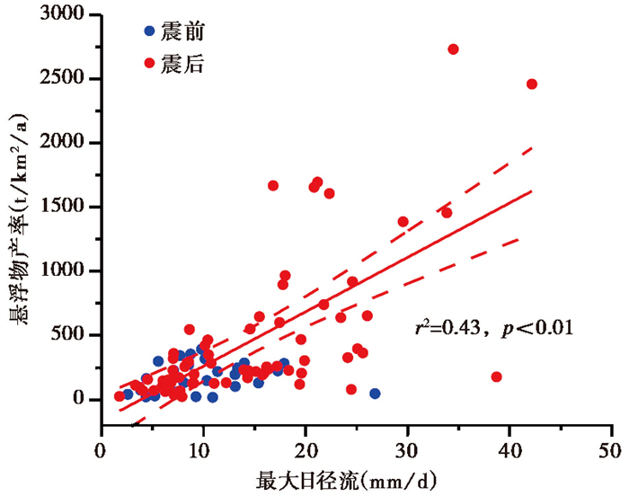
河流的沉积物通量还受控于河流的搬运能力,在碎屑颗粒物供给充足时,河流的搬运能力依赖于强径流[52~53]。既然2008年汶川地震造成的滑坡供给了大量的沉积物,我们拟合了龙门山地区岷江、涪江和沱江这三大河流最大日径流量与河流悬浮物产量之间的关系(图 5)。由图 5可知,地震之前,两者之前的关系不显著,属于供给制约型(supply-limited)河流体系;地震之后,悬浮物产量随着最大径流强度的增加而增加,两者呈一定的正相关关系。这说明地震后的沉积物供给状态发生了改变,成为搬运制约型(transport-limited)河流体系。综合其他地区地震产生滑坡物质输移的时间和气候条件[4, 24, 47]表明,滑坡物质在流域的滞留时间,不但取决于流域内滑坡数量,还与高强度的径流天数紧密相关。因此,在构造活动山脉,地震产生滑坡供给碎屑物质,而河流输移动力控制着滑坡滞留时间[13]和短时间的剥蚀速率[54]。值得指出的是,龙门山地区地处相对湿润的亚热带季风区,降水充沛、水系发达,因此滑坡物质的主要营力是河流搬运,上述认识主要适用于类似的湿润气候地区。而在气候干旱地区的构造活跃带(如青藏高原北部),风力或物质蠕滑(creep)等作用可能是更主要的搬运营力[55~56],滑坡物质的输送作用有待进一步研究。
|
图 5 龙门山地区三大河流(岷江、涪江和沱江)年最大日径流与悬浮物产量之间的关系 红色实线为地震之后两者的线性拟合,虚线表示95 %的置信区间 Fig. 5 Relationship between suspended sediment flux and maximum daily water discharge of three major rivers (the Minjiang River, the Fujiang River, and the Tuojiang River) draining the Longmen Shan. The red solid line shows best fit of post-earthquake data from linear regression and the dashed lines show the 95 % confidence bands of the fit |
大地震在导致大量的山体滑坡的同时,也会破坏大量的森林植被和土壤,这个过程造成大量有机碳的剥蚀[19~21],其中包含来自植物通过光合作用固定的现代POC,它是全球碳循环的重要组成部分,其埋藏是地质时间尺度重要的碳汇[57~58]。由2008年汶川地震造成的近6万个滑坡破坏的森林储备量约为13.6 Tg·C(1 Tg=1×10¹² g)[59],它相当于亚马逊河一年的POC通量[60~61]。本研究以岷江支流杂谷脑河为例,探讨地震滑坡对POC输移的影响。
杂谷脑河是岷江一条主要的支流,流域面积4629 km2。该流域植被丰富,主要的植被类型为自然林和灌木林。杂谷脑河地震滑坡面积12.5 km2,占整个流域面积的0.27 %,受到中等的滑坡破坏,地震之后下游对河流的物质贡献增加了2倍以上[13]。在2008年汶川地震前后(2006~2012年),杂谷脑河的POC含量和悬浮物浓度保持着良好的线性关系[28]。
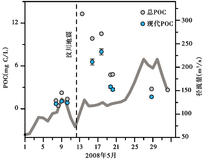
稳定碳同位素(14C)能够有效地分析河流悬浮物中有机碳的年龄组成,并计算现代和化石POC的比例[57~58],因为化石POC主要来源于变质沉积岩[62],河流对其的转移和埋藏并不代表消耗大气CO2[57~58]。通过分析2008年汶川地震前后杂谷脑河悬浮物POC含量及其13C和14C同位素比值,参照Galy等[63]的方法,运用两端元混合模型定量获得了河流现代POC比例。结果表明[28],杂谷脑河悬浮物Fmod(14C Fraction modern)变化区间为0.27~0.94,对应的14C年龄为10000~500年,δ13Corg变化于-25.7 ‰至-19.3 ‰之间,计算得到现代POC占总POC的61.7±14.1 %。在汶川地震之后几个月内,在径流量基本保持不变的情形下,杂谷脑河现代POC的含量增加了8倍(图 6),其变化幅度与悬浮物浓度的变化相当[28]。对杂谷脑河2006~2012年现代POC通量的计算结果显示,地震前(2006~2007年)的年际平均POC通量为4600±150 t C/a,而地震之后上升至5700±270 t C/a[28]。由此表明,即使该流域仅受到了地震滑坡的中度影响,2008年汶川地震之后4年里,滑坡剥蚀的POC快速进入河道,造成杂谷脑河下游的现代POC供给增加了约2倍至4倍[28]。重要的是,在这4年内,杂谷脑下游现代POC获益率并没有呈一个明显的降低趋势,这说明地震滑坡剥蚀的有机质供给河流搬运可能也是一个长期而缓慢的过程。
|
图 6 汶川地震前后杂谷脑河总POC、现代POC及径流量变化 Fig. 6 Changes of total POC, biospheric POC and water discharge (Qw)at Sangping station in the Zagunao River during May 2008 just before and after the 2008 Wenchuan earthquake |
那么地震滑坡剥蚀的现代POC在流域里将滞留多长时间?又有多少比例是以POC的形式被河流搬运出流域呢?假如不考虑POC的氧化降解,根据流域滑坡中现代POC总量和搬运速率,需要62±29 a才能将地震滑坡产生的全部现代POC搬运出流域;如果仅仅考虑土壤POC的话,则需要29±14 a[28]。事实上,在流域停留和河流搬运过程中,部分现代POC会被氧化降解,以CO2形式返回到大气中。于此,我们建立了Single-pool模型,模拟估算杂谷脑流域地震滑坡剥蚀的现代POC的氧化降解比例(即归宿)。这个模型同时考虑到河流对现代有机碳的搬运及其在流域滞留时的氧化降解。对于震后搬运制约型(transport-limited)的河流体系[11, 27]来说,在地震后的某个时间(t)内,滞留在流域的滑坡侵蚀有机碳的量(Mls)取决于河流的现代POC侵蚀速率(Er)和有机碳降解参数(k)[23, 64]:

|
(1) |
其中,k为碳周转时间(turnover time)的倒数。在模型中,假设地震后的河流现代POC侵蚀速率保持不变,以k=1 %/a、2 %/a和5 %/a分别模拟了氧化降解比例,其中5 %/a是从全球碳的平均周转时间(23+7/-4 a)[65]获得的,1 %/a则考虑了龙门山所处的高原低温环境,其碳周转时间要长[64~65]。杂谷脑河的年平均径流为530 mm/a,现代POC产量为1.6 t·C/km2/a。模拟结果显示,即使在全球平均氧化降解速率下(k=5 %/a),来自于汶川地震滑坡破坏的植被和土壤的POC并不会在山坡中被氧化降解,约有60 %现代POC会被河流运输出去[28]。假如这部分有机碳被有效埋藏,并长时间尺度保存于沉积物中的话,这将是一个很重要的碳汇过程[66]。虽然我们尚不能定量评估杂谷脑河的现代POC的埋藏效率,但是全球数据表明,高沉积速率有助于有机碳埋藏,因此地震之后剥蚀速率的增加[24]必然会增强POC的埋藏效率[23, 57, 67]。尽管有些研究认为在年到百年时间尺度上,滑坡破坏的森林和植被会被氧化降解,可能是一个碳源过程[59, 68]。而本研究认为,由地震引发的滑坡会导致河流现代POC侵蚀速率和埋藏效率同时增加,本机制将构造作用和大气CO2消耗联系到一起。
3 地震对河水化学和硅酸盐风化的影响硅酸盐风化是影响大气CO2浓度长期变化的主导作用之一,因此晚新生代以来全球气温变冷被归因于喜马拉雅-青藏高原隆升引起的陆地化学风化率及通量增大[69~74]。“构造隆升-化学风化-气候变化”假说的核心就是构造作用是否增强了硅酸盐化学风化强度(消耗大气CO2)[74~76],但已有的证据主要来自海洋沉积物和河水化学所记录的硅酸盐风化,一直缺乏两者联系的直接证据。事实上,最直接的解决方法是开展单一构造事件前后风化通量的对比研究,确定构造运动对流域侵蚀和风化影响的强度、幅度和范围,乃至持续的时间。2008年汶川地震前后岷江河水化学的变化为构造活动对河水化学的影响提供了直接有力的证据,将构造活动与硅酸盐风化直接地联系到一起。
岷江河水化学结果显示,地震之后岷江输运的总溶质通量系统增加,特别是,与地震之前数据相比,河水的Na*/Ca(Na*为经大气和蒸发盐校正的Na+离子含量)增加了近4倍;尽管地震前后河水中Sr2+含量比较接近,但是87Sr/86Sr同位素比值却从地震前(2001年)的0.712663±0.000200增加到0.713307±0.000207,增加了0.000644±0.000146[29]。这个变化远远超出了龙门山地区泥盆纪海相灰岩的87Sr/86Sr组成(0.70788~0.70868,平均为0.70823±0.00020)[77]。因此,2008年汶川地震之后岷江河水中增加的87Sr/86Sr比值是硅酸盐组分加入的直接结果。元素和Sr同位素比值的这些变化,直接指示了汶川地震之后岷江河水中硅酸盐组分及其导致的碱度显著增加。因硅酸盐组分引起的河水碱度变化计算得到的CO2消耗量比震前增加了4.3±0.4倍[29]。
结合流域内地震峰值加速度(peak ground accelerations,简称PGA)和地震形成的滑坡密度与Na*/Ca和87Sr/86Sr同位素比值的关系,汶川地震之后岷江河水中硅酸盐组分和碱度的增加可能主要是深部地下水的释放和包括滑坡在内的新鲜破碎岩石的快速淋滤风化的结果[29]。那么,地震之后增加的CO2消耗量包括滑坡物质快速风化消耗的现代大气CO2以及来自于深部地下水HCO3-,这两个来源的比例有待进一步研究。尽管深部水岩反应很可能没有直接消耗现代大气CO2,但是深部地下水HCO3-还是来源于溶解于水体的或深部释放的CO2,仍然代表了长尺度上的碳汇。另一个重要的现象是,我们测试结果表明这些硅酸盐组分在地震后的几年内一直保持在较高的水平(图 7),暗示着与滑坡侵蚀一样,这样的影响将会持续很长的时间。如果其他大地震也会引起类似的变化,那么由地震引发的河流硅酸盐溶质输运的增加将把风化和碱度与构造活动直接联系起来。

|
图 7 岷江干道(威州站)2010~2012年季节性河水Na*/Ca变化(粉红色) 蓝色符号及误差线为年平均及方差 Fig. 7 The annual time series of Na*/Ca ratios(pink diamonds)of seasonal river waters during 2010 and 2012 collected from the Weizhou hydrological station at the main stem of the Minjiang River, with annual averages and their standard deviations (blue diamonds and bars) |
为了评估地震对地质时间尺度山脉剥蚀的影响及机制,我们模拟建立了龙门山地区地震震级-滑坡体积、地震震级-复发频次的关系,进而计算了百万年内仅由滑坡产生的碎屑物质提供的剥蚀通量,即理论上的“地震引发的剥蚀速率”(seismic erosion rate)[54]。根据2008年汶川地震和2013年芦山地震引发的滑坡体积数据,我们模拟计算了龙门山地区地震震级与滑坡体积的对应关系(图 8a)。两者之间具有良好的对数关系(r2=0.99),由此可以计算获得不同震级下产生的滑坡体积。与此同时,利用龙门山地区的地震台站数据和古地震研究数据,我们依据地震学的Gutenburg-Ricther方程建立了地震震级-复发频次的关系(图 8b)。实测和模拟结果表明,类似2008年汶川地震震级的复发周期为500~4000 a[40, 54, 78~79],而复发周期为500 a的地震遵循经典的Gutenburg-Ricther线性方程[79]。结合地震震级-滑坡体积关系和地震震级-复发频次关系,我们计算了在过去数百万年内,仅由滑坡产生的碎屑物质提供的剥蚀通量,即理论上的“地震引发的剥蚀速率”(图 8c)。计算得到的理论剥蚀速率为0.44~0.96 mm/a,集中于0.5~0.8 mm/a[54]。

|
图 8 (a) 模拟计算的龙门山地区地震震级与滑坡体积关系,黑色十字为模拟的20个5~8级地震的滑坡体积,红色实线为滑坡体积与地震震级之间的最优拟合曲线;(b)龙门山地区地震震级与累积频次的关系;(c)模拟计算的地震滑坡剥蚀速率与汶川地震复发周期的关系(改自文献[54]) Fig. 8 (a)Longmen Shan-specific, seismologically-based landslide volume model; the crosses represent the modeled landslide volumes for 20 earthquakes with magnitude from 5 to 8; the red solid curve represents the best fit of the modeled landslide volumes as a function of earthquake magnitude. (b)Longmen Shan earthquake magnitude-frequency relation; (c)Calculated seismic erosion rate with the Longmen Shan seismologically-based landslide volume model as a function of the estimated recurrence interval for Wenchuan-alike events (revised from reference[54]) |
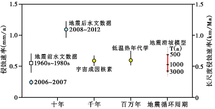
通过汇总龙门山地区的宇宙成因核素10Be年代学(千年尺度平均剥蚀速率为0.55±0.05 mm/a)与低温热年代学(百万年尺度平均剥蚀速率为0.61+0.14/-0.08 mm/a)测量的长尺度剥蚀速率[31, 80~81],实际观测的剥蚀速率与理论预测的地震剥蚀速率大致相当,都在0.5~1.0 mm/a范围内(图 9)。此外,龙门山地区实测的长尺度剥蚀速率的空间分布与汶川地震的滑坡空间分布也基本重合[54]。这些现象表明,在龙门山地区,地质时间尺度上的剥蚀通量很可能主要是由地震引发的滑坡碎屑物质提供的,岷江等流经龙门山的长江主要支流拥有的高悬浮物通量是不同级别地震引发的滑坡叠加剥蚀的长期表现。这为全球广泛观测到的山前地区的高剥蚀通量提供了一种新的机制解释:强烈剥蚀很可能是受控于强震断层系统,不同于以往认为的主要受控于山前强降水或者陡峭地形[54]。
|
图 9 龙门山地区不同时间尺度上的剥蚀速率以及相关的测量方法(改自文献[54]) 10年尺度上的剥蚀速率由水文数据获得;千年尺度上的剥蚀速率由宇宙成因核素年代学方法测得;百万年尺度上的剥蚀速率由低温热年代学方法测得;地震循环周期(数千年至数百万年)时间尺度上的剥蚀速率由地震滑坡体积模型计算获得 Fig. 9 Erosion rates of the frontal Longmen Shan across different timescales (revised from reference[54]). Erosion rates determined from hydrological gauging over decadal time scales, from measure ̄ments of cosmogenic nuclides over millennial scales, from low temperature thermochronology analysis over timescales of millions of years, and from the Longmen Shan-specific, seismologically-based landslide volume model for timescale of earthquake cycles(over thousands to millions of years) |
通过2008年汶川特大地震前后河流悬浮物、颗粒有机碳(POC)及河水化学变化的对比研究,定量评价了现代构造活动对流域侵蚀、风化及有机碳输移的影响及其持续时间;结合2013年芦山地震以及滑坡体积与地震震级和复发频次关系,提出了地震滑坡对以龙门山为代表的活跃造山带长时间尺度剥蚀速率控制的新机制。
2008年汶川地震在龙门山地区产生了近6万个山体滑坡,在地震后的5年时间内,岷江、沱江和涪江下游的悬浮物通量平均增加了3至7倍。由悬浮物通量换算得到的剥蚀速率与地震滑坡体积有很好的相关性,表明地震滑坡对流域侵蚀的直接贡献,而滑坡密度和高强度径流是控制滑坡物质搬运时间的两大主要因素。按目前的悬浮物搬运速率,将汶川地震产生的滑坡物质搬运出流域的时间需要几十年,甚至几千年,才可回到地震前水平。考虑到地震滑坡对剥蚀的深远影响及其高的地震复发频次,龙门山地区实际观测和模拟的地震滑坡造成的剥蚀速率在0.5~1.0 mm/a范围内,其与千年至百万年尺度的长尺度剥蚀速率大致相当,由此提出构造活跃区地质时间尺度上的剥蚀通量很可能主要是由地震引发的滑坡碎屑物质提供的,而径流强度则控制着滑坡滞留时间和短时间的剥蚀速率。这为全球广泛观测到的、陡峭的山前地区高剥蚀通量提供了一种新的解释机制。
与地震滑坡剥蚀同步的是河流现代POC和河水溶质的成倍增加。汶川地震造成河流现代POC供给也增加了约2至4倍,且这些由地震滑坡破坏的POC会被河流快速搬运出去,预计只有少部分会被氧化降解。汶川地震之后岷江河水的碱度和硅酸盐风化通量则增加了4倍左右,由此造成的CO2消耗通量和87Sr/86Sr比值分别增加了4.3±0.4倍和0.000644±0.000146。如果其他的地震也有类似汶川地震引起的有机碳埋藏和硅酸盐碳消耗成倍增加的双重碳汇效应,那么地震滑坡可能在调节长时间尺度大气CO2和全球气候中起着重要的作用。
以2008年汶川大地震为代表的高强度构造事件对龙门山构造带的地表过程产生重大而深远的影响,不但在地震之后的数十年至百年内增加剥蚀、风化与POC输移通量,更可能在构造时间尺度上控制山脉剥蚀与演化,从而进一步调控碳循环与气候系统,对“构造-风化-碳循环-气候”耦合具有重要意义。本研究为量化高强度构造事件对流域剥蚀-风化作用的直接影响及其碳消耗提供最直接、可靠的数据,地震将构造活动与流域剥蚀-风化和碳收支直接地联系到一起,为“构造隆升-化学风化-气候变化”假说提供有力的证据和机制解释。
致谢 衷心感谢中国科学院地球环境研究所安芷生先生、南加州大学A. Joshua West博士、杜伦大学Robert Hilton博士和Alexander Densmore教授对本项工作的长期支持及对数据解释给予的建设性建议;感谢同行评审专家和编辑部老师提出的宝贵修改意见!
| 1 |
Avouac J P. Dynamic processes in extensional and compressional settings-mountain building: From earthquakes to geological deformation[C]//Watts A B. Crustal and Lithosphere Dynamics. Treatise on Geophysics, 2008, 6: 377-439.
|
| 2 |
Anderson R S, Anderson S P. Geomorphology: The Mechanics and Chemistry of Landscapes[M]. Cambridge: Cambridge University Press, 2010: 60-95, 160-211. http://www.researchgate.net/publication/258423910_Geomorphology_The_mechanics_and_chemistry_of_landscapes
|
| 3 |
Parker R N, Densmore A L, Rosser N J et al. Mass wasting triggered by the 2008 Wenchuan earthquake is greater than orogenic growth. Nature Geoscience, 2011, 4(7): 449-452. DOI:10.1038/ngeo1154 |
| 4 |
Hovius N, Meunier P, Lin Ching-Weei et al. Prolonged seismically induced erosion and the mass balance of a large earthquake. Earth and Planetary Science Letters, 2011, 304(3-4): 347-355. DOI:10.1016/j.epsl.2011.02.005 |
| 5 |
Li G, West A J, Densmore A L et al. Seismic mountain building:Landslides associated with the 2008 Wenchuan earthquake in the context of a generalized model for earthquake volume balance. Geochemistry, Geophysics, Geosystems, 2014, 15: 833-844. DOI:10.1002/ggge.v15.4 |
| 6 |
Marc O, Hovius N, Meunier P et al. A seismologically consistent expression for the total area and volume of earthquake-triggered landsliding. Journal of Geophysical Research:Earth Surface, 2016, 121(4): 2015JF003732. |
| 7 |
Keefer D K. The importance of earthquake-induced landslides to long-term slope erosion and slope-failure hazards in seismically active regions. Geomorphology, 1994, 10(1-4): 265-284. DOI:10.1016/0169-555X(94)90021-3 |
| 8 |
Sato H P, Hasegawa H, Fujiwara S et al. Interpretation of landslide distribution triggered by the 2005 Northern Pakistan earthquake using SPOT5 imagery. Landslides, 2007, 4(2): 113-122. DOI:10.1007/s10346-006-0069-5 |
| 9 |
Chigira M, Wu X, Inokuchi T et al. Landslides induced by the 2008 Wenchuan earthquake, Sichuan, China. Geomorphology, 2010, 118(3-4): 225-238. DOI:10.1016/j.geomorph.2010.01.003 |
| 10 |
Malamud B D, Turcotte D L, Guzzetti F et al. Landslides, earthquakes, and erosion. Earth and Planetary Science Letters, 2004, 229(1-2): 45-59. DOI:10.1016/j.epsl.2004.10.018 |
| 11 |
Hovius N, Stark C P, Chu H-T et al. Supply and removal of sediment in a landslide-dominated mountain belt:Central Range, Taiwan. Journal of Geology, 2000, 108(1): 73-89. DOI:10.1086/314387 |
| 12 |
Larsen I J, Montgomery D R, Korup O. Landslide erosion controlled by hillslope material. Nature Geoscience, 2010, 3(4): 247-251. DOI:10.1038/ngeo776 |
| 13 |
Wang J, Jin Z, Hilton R G et al. Controls on fluvial evacuation of sediment from earthquake-triggered landslides. Geology, 2015, 43(2): 115-118. DOI:10.1130/G36157.1 |
| 14 |
Meunier P, Hovius N, Haines A J. Regional patterns of earthquake-triggered landslides and their relation to ground motion. Geophysical Research Letters, 2007, 34(20): L20408. DOI:10.1029/2007GL031337 |
| 15 |
Lyons W B, Carey A E, Hicks D M et al. Chemical weathering in high-sediment-yielding watersheds, New Zealand. Journal of Geophysical Research:Earth Surface, 2005, 110(F1): F01008. DOI:10.1029/2003JF000088 |
| 16 |
Emberson R, Hovius N, Galy A et al. Chemical weathering in active mountain belts controlled by stochastic bedrock landsliding. Nature Geoscience, 2016, 9(1): 42-45. DOI:10.1038/ngeo2600 |
| 17 |
Guzzetti F, Ardizzone F, Cardinali M et al. Landslide volumes and landslide mobilization rates in Umbria, Central Italy. Earth and Planetary Science Letters, 2009, 279(3-4): 222-229. DOI:10.1016/j.epsl.2009.01.005 |
| 18 |
Jacobson A D, Blum J D, Chamberlain C P et al. Climatic and tectonic controls on chemical weathering in the New Zealand Southern Alps. Geochimica et Cosmochimica Acta, 2003, 67(1): 29-46. DOI:10.1016/S0016-7037(02)01053-0 |
| 19 |
Garwood N C, Janos D P, Brokaw N. Earthquake-caused landslides:A major disturbance to tropical forests. Science, 1979, 205(4410): 997-999. DOI:10.1126/science.205.4410.997 |
| 20 |
Restrepo C, Walker L R, Shiels A B et al. Landsliding and its multiscale influence on mountainscapes. Bioscience, 2009, 59(8): 685-698. DOI:10.1525/bio.2009.59.8.10 |
| 21 |
Hilton R G, Meunier P, Hovius N et al. Landslide impact on organic carbon cycling in a temperate montane forest. Earth Surface Processes and Landforms, 2011, 36(12): 1670-1679. DOI:10.1002/esp.v36.12 |
| 22 |
Lin G-W, Chen H, Hovius N et al. Effects of earthquake and cyclone sequencing on landsliding and fluvial sediment transfer in a mountain catchment. Earth Surface Processes and Landforms, 2008, 33(33): 1354-1373. |
| 23 |
Blair N E, Aller R C. The fate of terrestrial organic carbon in the marine environment. Annual Review of Marine Science, 2012, 4: 401-423. DOI:10.1146/annurev-marine-120709-142717 |
| 24 |
Howarth J D, Fitzsimons S J, Norris R J et al. Lake sediments record cycles of sediment flux driven by large earthquakes on the Alpine Fault, New Zealand. Geology, 2012, 40(12): 1091-1094. DOI:10.1130/G33486.1 |
| 25 |
Ouimet W B. Landslides associated with the May 12, 2008 Wenchuan earthquake:Implications for the erosion and tectonic evolution of the Longmen Shan. Tectonophysics, 2010, 491(1-4): 244-252. DOI:10.1016/j.tecto.2009.09.012 |
| 26 |
Ding H, Li Y, Ni S et al. Increased sediment discharge driven by heavy rainfall after Wenchuan earthquake:A case study in the upper reaches of the Min River, Sichuan, China. Quaternary International, 2014, 333: 122-129. DOI:10.1016/j.quaint.2014.01.019 |
| 27 |
West A J, Hetzel R, Li G et al. Dilution of 10Be in detrital quartz by earthquake-induced landslides:Implications for determining denudation rates and potential to provide insights into landslide sediment dynamics. Earth and Planetary Science Letters, 2014, 396: 143-153. DOI:10.1016/j.epsl.2014.03.058 |
| 28 |
Wang J, Jin Z D, Hilton R G et al. Earthquake-triggered increase in biospheric carbon export from a mountain belt. Geology, 2016, 44(6): 471-474. DOI:10.1130/G37533.1 |
| 29 |
Jin Z D, West A J, Zhang F et al. Seismically enhanced solute fluxes in the Yangtze River headwaters following the A. D. 2008 Wenchuan earthquake. Geology, 2016, 44(1): 47-50. DOI:10.1130/G37246.1 |
| 30 |
Li G, West A J, Densmore A L et al. Connectivity of earthquake-triggered landslides with the fluvial network:Implications for sediment transport after the 2008 Wenchuan earthquake. Journal of Geophysical Research:Earth Surface, 2016, 121: 703-724. DOI:10.1002/2015JF003718 |
| 31 |
Kirby E, Reiners P W, Krol M A et al. Late Cenozoic evolution of the eastern margin of the Tibetan Plateau:Inferences from 40Ar/39Ar and(U-Th)/He thermochronology. Tectonics, 2002, 21. DOI:10.1029/2000TC001246 |
| 32 |
Chappell J, Zheng H, Fifield K. Yangtse River sediments and erosion rates from source to sink traced with cosmogenic 10Be:Sediments from major rivers. Palaeogeography, Palaeoclimatology, Palaeoecology, 2006, 241(1): 79-94. DOI:10.1016/j.palaeo.2006.06.010 |
| 33 |
Qin J, Huh Y, Edmond J et al. Chemical and physical weathering in the Minjiang, a headwater tributary of the Yangtze River. Chemical Geology, 2006, 227: 53-69. DOI:10.1016/j.chemgeo.2005.09.011 |
| 34 |
Yoon J, Huh Y, Lee I et al. Weathering processes in the Minjiang:Major elements, 87Sr/86Sr, δ34SSO4, and δ18OSO4. Aquatic Geochemistry, 2008, 14: 147-170. DOI:10.1007/s10498-008-9030-7 |
| 35 |
Liu-Zeng J, Wen L, Oskin M et al. Focused modern denudation of the Longmen Shan margin, eastern Tibetan Plateau. Geochemistry, Geophysics, Geosystems, 2011, 12(11): Q11007. |
| 36 |
Parsons T, Ji C, Kirby E. Stress changes from the 2008 Wenchuan earthquake and increased hazard in the Sichuan Basin. Nature, 2008, 454(7203): 509-510. DOI:10.1038/nature07177 |
| 37 |
Hubbard J, Shaw J H. Uplift of the Longmen Shan and Tibetan Plateau, and the 2008 Wenchuan (M=7.9) earthquake. Nature, 2009, 458(7235): 194-197. DOI:10.1038/nature07837 |
| 38 |
Huang R, Fan X. The landslide story. Nature Geoscience, 2013, 6(5): 325-326. DOI:10.1038/ngeo1806 |
| 39 |
李勇, 周荣军, Densmore A L等. 青藏高原东缘龙门山晚新生代走滑-逆冲作用的地貌标志. 第四纪研究, 2006, 26(1): 40-51. Li Yong, Zhou Rongjun, Densmore A L et al. Geomorphic evidence for the Late Cenozoic strike-slipping and thrusting in Longmen Mountain at the eastern margin of the Tibetan Plateau. Quaternary Sciences, 2006, 26(1): 40-51. |
| 40 |
Densmore A L, Ellis M A, Li Y et al. Active tectonics of the Beichuan and Pengguan faults at the eastern margin of the Tibetan Plateau. Tectonics, 2007, 26(4). DOI:10.1029/2006tc001987 |
| 41 |
Burchfiel B C, Royden L H, van der Hilst R D et al. A geological and geophysical context for the Wenchuan earthquake of 12 May 2008, Sichuan, People's Republic of China. GSA Today, 2008, 18(7). DOI:10.1130/GSATG18A.1 |
| 42 |
Clark M K, Royden L H. Topographic ooze:Building the eastern margin of Tibet by lower crustal flow. Geology, 2000, 28(8): 703-706. DOI:10.1130/0091-7613(2000)28<703:TOBTEM>2.0.CO;2 |
| 43 |
Dai F C, Xu C, Yao X et al. Spatial distribution of landslides triggered by the 2008MS8.0 Wenchuan earthquake, China. Journal of Asian Earth Sciences, 2011, 40(4): 883-895. DOI:10.1016/j.jseaes.2010.04.010 |
| 44 |
Xu C, Xu X, Shyu J B H. Database and spatial distribution of landslides triggered by the Lushan, China MW6.6 earthquake of 20 April 2013. Geomorphology, 2015, 248: 77-92. DOI:10.1016/j.geomorph.2015.07.002 |
| 45 |
Dadson S J, Hovius N, Chen H et al. Links between erosion, runoff variability and seismicity in the Taiwan orogen. Nature, 2003, 426(6967): 648-651. DOI:10.1038/nature02150 |
| 46 |
Fuller C W, Willett S D, Hovius N et al. Erosion rates for Taiwan mountain basins:New determinations from suspended sediment records and a stochastic model of their temporal variation. Journal of Geology, 2003, 111(1): 71-87. DOI:10.1086/344665 |
| 47 |
Dadson S J, Hovius N, Chen H et al. Earthquake-triggered increase in sediment delivery from an active mountain belt. Geology, 2004, 32(8): 733-736. DOI:10.1130/G20639.1 |
| 48 |
Ohmori H. Dynamics and erosion rate of the river running on a thick deposit supplied by a large landslide. Zeitschrift Fur Geomorphologie, 1992, 36: 129-140. |
| 49 |
Koi T, Hotta N, Ishigaka I et al. Prolonged impact of earthquake-induced landslides on sediment yield in a mountain watershed:The Tanzawa region, Japan. Geomorphology, 2008, 101(4): 692-702. DOI:10.1016/j.geomorph.2008.03.007 |
| 50 |
Korup O. Large landslides and their effect on sediment flux in South Westland, New Zealand. Earth Surface Processes and Landforms, 2005, 30(3): 305-323. DOI:10.1002/(ISSN)1096-9837 |
| 51 |
Lin W, Lin C, Chou W. Assessment of vegetation recovery and soil erosion at landslides caused by a catastrophic earthquake. Ecological Engineering, 2006, 28(1): 79-89. DOI:10.1016/j.ecoleng.2006.04.005 |
| 52 |
Ma C, Wang Y, Hu K et al. Rainfall intensity-duration threshold and erosion competence of debris flows in four areas affected by the 2008 Wenchuan earthquake. Geomorphology, 2017, 282: 85-95. DOI:10.1016/j.geomorph.2017.01.012 |
| 53 |
Chen H, Lin G-W, Lu M-H et al. Effects of topography, lithology, rainfall and earthquake on landslide and sediment discharge in mountain catchments of southeastern Taiwan. Geomorphology, 2011, 133(3-4): 132-142. DOI:10.1016/j.geomorph.2010.12.031 |
| 54 |
Li G, West A J, Densmore A L et al. Earthquakes drive focused denudation along a tectonically active mountain front. Earth and Planetary Science Letters, 2017, 472: 253-265. DOI:10.1016/j.epsl.2017.04.040 |
| 55 |
Cannell G H, Weeks L V. Erosion and its control in semi-arid regions[C]//Hall A E, Cannell G H, Lawton H W. Agriculture in Semi-Arid Environments Ecological Studies (Analysis and Synthesis), No. 34. Berlin, Heidelberg: Springer, 1979: 238-256.
|
| 56 |
Dong Z, Wang X, Liu L. Wind erosion in arid and semiarid China:An overview. Journal of Soil and Water Conservation, 2000, 55(4): 439-444. |
| 57 |
Galy V, France-Lanord C, Beyssac O et al. Efficient organic carbon burial in the Bengal fan sustained by the Himalayan erosional system. Nature, 2007, 450(7168): 407-410. DOI:10.1038/nature06273 |
| 58 |
Hilton R G, Galy A, Hovius N et al. Tropical-cyclone-driven erosion of the terrestrial biosphere from mountains. Nature Geoscience, 2008, 1(11): 759-762. DOI:10.1038/ngeo333 |
| 59 |
Chen H, Wu N, Yuan X et al. Aftermath of the Wenchuan earthquake. Frontiers in Ecology and the Environment, 2009, 7(2): 72. |
| 60 |
Richey J E, Hedges J I, Devol A H et al. Biogeochemistry of carbon in the Amazon River. Limnology and Oceanography, 1990, 35(2): 352-371. DOI:10.4319/lo.1990.35.2.0352 |
| 61 |
Moreira-Turcq P, Seyler P, Guyot J L et al. Exportation of organic carbon from the Amazon River and its main tributaries. Hydrological Processes, 2003, 17(7): 1329-1344. DOI:10.1002/(ISSN)1099-1085 |
| 62 |
Burchfiel B C, Chen Z, Liu Y et al. Tectonics of the Longmen Shan and adjacent regions, Central China. International Geology Review, 1995, 37(8): 661-735. DOI:10.1080/00206819509465424 |
| 63 |
Galy V, Beyssac O, France-Lanord C et al. Recycling of graphite during Himalayan erosion:A geological stabilization of carbon in the crust. Science, 2008, 322(5903): 943-945. DOI:10.1126/science.1161408 |
| 64 |
Trumbore S. Age of soil organic matter and soil respiration:Radiocarbon constraints on belowground C dynamics. Ecological Applications, 2000, 10(2): 399-411. DOI:10.1890/1051-0761(2000)010[0399:AOSOMA]2.0.CO;2 |
| 65 |
Carvalhais N, Forkel M, Khomik M et al. Global covariation of carbon turnover times with climate in terrestrial ecosystems. Nature, 2014, 514(7521): 213-217. DOI:10.1038/nature13731 |
| 66 |
Berner R A. Burial of organic carbon and pyrite sulfur in the modern ocean:Its geochemical and environmental significance. American Journal of Science, 1982, 282(4): 451-473. DOI:10.2475/ajs.282.4.451 |
| 67 |
Burdige D J. Burial of terrestrial organic matter in marine sediments:A re-assessment. Global Biogeochemical Cycles, 2005, 19: GB4011. |
| 68 |
Chambers J Q, Fisher J I, Zeng H et al. Hurricane Katrina's carbon footprint on U.S. Gulf Coast forests. Science, 2007, 318(5853): 1107. DOI:10.1126/science.1148913 |
| 69 |
Richter F M, Rowley D B, DePaolo D J. Sr isotope evolution of sea water:The role of tectonics. Earth and Planetary Science Letters, 1992, 109: 11-23. DOI:10.1016/0012-821X(92)90070-C |
| 70 |
Edmond J M. Himalayan tectonics, weathering processes, and the strontium isotope record in marine limestones. Science, 1992, 258(5088): 1594-1597. DOI:10.1126/science.258.5088.1594 |
| 71 |
Raymo M, Ruddiman W F. Tectonic forcing of Late Cenozoic climate. Nature, 1992, 359(6391): 117-122. DOI:10.1038/359117a0 |
| 72 |
Derry L A, France-Lanord C. Neogene Himalayan weathering history and river 87Sr/86Sr:Impact on the marine Sr record. Earth and Planetary Science Letters, 1996, 142(1-2): 59-74. DOI:10.1016/0012-821X(96)00091-X |
| 73 |
Jacobson A D, Blum J D, Walter L M. Reconciling the elemental and Sr isotope composition of Himalayan weathering fluxes:Insights from the carbonate geochemistry of stream waters. Geochimica et Cosmochimica Acta, 2002, 66(19): 3417-3429. DOI:10.1016/S0016-7037(02)00951-1 |
| 74 |
Ruddiman W F ed. Tectonic Uplift and Climate Change[M]. New York: Plenum Press, 1997: 239-365, 399-515. http://link.springer.com/978-1-4615-5935-1
|
| 75 |
Willenbring J K, Blanckenburg F. Long-term stability of global erosion rates and weathering during Late-Cenozoic cooling. Nature, 2010, 465(7295): 211-214. DOI:10.1038/nature09044 |
| 76 |
Torres M A, West A J, Li G. Sulphide oxidation and carbonate dissolution as a source of CO2 over geological timescales. Nature, 2014, 507(7492): 346-349. DOI:10.1038/nature13030 |
| 77 |
黄思静, 石和, 张萌等. 龙门山泥盆纪锶同位素演化曲线的全球对比及海相地层的定年. 自然科学进展, 2002, 12(9): 945-951. Huang Sijing, Shi He, Zhang Meng et al. Global correlation of Devonian Sr isotope evolution at Longmen Shan and chronology of marine strata. Progress in Natural Science, 2002, 12(9): 945-951. |
| 78 |
Shen Z K, Sun J B, Zhang P Z et al. Slip maxima at fault junctions and rupturing of barriers during the 2008 Wenchuan earthquake. Nature Geoscience, 2009, 2(10): 718-724. DOI:10.1038/ngeo636 |
| 79 |
Thompson T B, Plesch A, Shaw J H et al. Rapid slip-deficit rates at the eastern margin of the Tibetan Plateau prior to the 2008MW7.9 Wenchuan earthquake. Geophysical Research Letters, 2015, 42(6): 1677-1684. DOI:10.1002/2014GL062833 |
| 80 |
Ouimet W B, Whipple K X, Granger D E. Beyond threshold hillslopes:Channel adjustment to base-level fall in tectonically active mountain ranges. Geology, 2009, 37(7): 579-582. DOI:10.1130/G30013A.1 |
| 81 |
Godard V, Lave J, Carcaillet J et al. Spatial distribution of denudation in eastern Tibet and regressive erosion of plateau margins. Tectonophysics, 2010, 491(1-4): 253-274. DOI:10.1016/j.tecto.2009.10.026 |
2 Institute of Global Environmental Change, Xi'an Jiaotong University, Xi'an 710049, Shaanxi;
3 Department of Geography, Durham University, Durham, DH1 3LE, UK;
4 Department of Earth Sciences, University of Southern California, Los Angeles, CA 90089, USA)
Abstract
The linkage between tectonic activities and erosion and silicate weathering remains a matter of debate. Hypotheses for a tectonic trigger are based mainly on the temporal coincidence of the uplift and erosion of the world's great mountain ranges (mainly the Himalayas)and the seawater 87Sr/86Sr rise from 40 Ma, resulting from high radiogenic Sr fluxes by enhanced silicate weathering along the river waters draining these uplifted mountains. However, evidences so-far for supporting or doubting the hypothesis are indirect, either from the oceanic records preserved in marine sediment, or from the modern-day studies of physical erosion, chemical weathering, organic carbon transfer, and their relationships in tectonically active regions; the latter has been mainly focused upon the dissolved loads of the rivers draining the Himalayas-Tibetan Plateau, because these tectonically active areas have the highest rates of total denudation coupling with large silicate weathering fluxes and large sedimentary organic carbon burial. However, direct empirical evidence still lacks following high magnitude tectonic events (e.g., earthquakes). Such direct studies are rare on what magnitude large tectonic events impact erosion and weathering processes and its mechanism, because those events occur rarely and often lack sufficient background pre-event data. The 2008 MW7.9 Wenchuan and 2013 MW6.6 Lushan earthquakes occurred along the Longmen Shan orogen at the eastern margin of the Tibetan Plateau, triggered massive landslides, and caused significant changes in surface processes and the carbon cycle. With sufficient studies in this region from before the earthquakes, the two recent earthquakes provide a good opportunity to explore how high magnitude tectonic events affect erosion, weathering and the carbon cycle over various timescales. In this study, we assess erosion, transfer of biospheric particulate organic carbon (POCbiosphere)and riverine solute in the context of the widespread landslides triggered by the Wenchuan earthquake during five years following the main shock. We propose that long-term erosion rates along a high-relief active plateau margin may be regulated by the resulting earthquake-triggered landslides, by combining with the close relation of earthquake-triggered landslide volume with earthquake magnitude and recurrence interval, as we observe for the Longmen Shan case. The results showed that suspended sediment discharge within five years following the earthquake was elevated 3~7 times compared to prior to the Wenchuan earthquake, indicating a significant contribution of earthquake-triggered landslides to catchment erosion, with an emphasis of the importance of landslide density and runoff intensity in setting the duration of earthquake-triggered landslide impacts on river systems. Following the post-earthquake erosion rate (ca. 0.5~1.0 mm/a)calculated by sediment flux and estimated using the Longmen Shan-specific landslide volume model, we find that the residence times of sediment associated with landslides in the Longmen Shan catchments range from decades (for fine sediment transported as suspended load)to thousands of years (for coarser materials transported as bedload), and the time scale is comparable to the estimated recurrence interval for Wenchuan-alike events. Accompanying enhanced sediment flux, the riverine fluxes of POCbiosphere and solute multiplied following the earthquake. The riverine POCbiosphere flux in the lower reaches of the Zagunao River (one of the major tributaries of the Minjiang River)enhanced 2~4 times following the large earthquake and the rapid export of POCbiosphere from earthquake-triggered landslides likely outpaced its degradation on hillslopes. Meanwhile, the riverine fluxes of alkalinity and silicate weathering solute redoubled after the earthquake, meaning 4.3±0.4 times increase in CO2 consumption rate via silicate-derived alkalinity and a 0.000644±0.000146 increase in 87Sr/86Sr isotopic ratios. To extrapolate the short-term observations to longer geological timescales, we combined landslide and seismic catalog data, modelled the long-term seismically induced landsliding rate (i.e., "seismic erosion rate"), and compared with the regional long-term erosion rates as measured from cosmogenic nuclides and low temperature thermochronology. We propose that long-term erosion across the Longmen Shan is likely sustained by earthquake-triggered landslides, and highlight the role of earthquakes and seismogenic faults in the erosional budget in steep mountains along high-relief active plateau margins. Overall, our study provides a direct link between seismotectonic activities, erosion, weathering and the carbon cycle. If such changes happen in other tectonically active mountain ranges, earthquakes and associated landslides likely play an important but underestimated role in regulating Earth's long-term carbon cycle and the evolution of the global climate system. 2018, Vol.38
