 2018, Vol.38


2 重庆地震局, 重庆 401147;
3 北京地震局, 北京 100080)
活动造山带地区的宏观地貌特征是构造抬升以及侵蚀和沉积等地表过程之间相互作用的结果,涉及到构造、气候、和地表过程之间的复杂联系[1]。过去十多年地球科学的重要进展之一是认识并证实了气候、地表过程以及构造和深部岩石圈过程之间存在的广泛相互作用[2~9](图 1a)。一方面,构造变形和深部岩石圈过程导致的高地形可以影响区域甚至全球气候[10~15];另一方面,气候变化导致的侵蚀增强可以改变构造变形的样式和速率,驱动岩石的均衡抬升并改变地壳应力状态和流变性质[6~7, 16~19]。这些相互作用控制着地貌侵蚀速率以及地貌响应构造和气候变化的灵敏度,涉及的时间尺度从单次暴雨和地震事件到数百万年的地质过程[20],因此,获得活动造山带侵蚀速率及其时空分布样式是解析构造、地表过程和气候变化之间相互作用的关键切入点之一。过去数十年时间,全球大部分地区数字地形数据的共享程度不断增加,使我们可以定量获取不同空间尺度的地貌特征并进行多方面的对比[21~26];同时低温热年代技术和宇宙成因核素技术的发展[27~32],提升了测定地貌和构造事件年龄的能力,这些方面的新进展为我们理解地貌的动态演化过程和探究构造、地表过程与气候之间的相互作用提供了新机遇。

|
图 1 (a) 气候、地表过程与构造和深部岩石圈过程之间相互作用示意图(引自Champagnac等[9]);(b)地貌从均衡状态到瞬时状态的形态及其演化历史(根据Reinhardt等[38]修改);(c)均衡地貌和瞬时地貌状态河流下切和山坡下降之间关系图(根据Burbank和Anderson[1]修改) Fig. 1 (a)The interactions between climate, surface processes, and tectonics and deep processes(quoted from Champagnac et al.[9]); (b)The landscape evolution from equilibrium state to transient state(modified based on Reinhardt et al.[38]); (c)The relationship between river incision and hillslope lowering for equilibrium and transient landscape(modified based on Burbank and Anderson[1]) |
通过河流河道和附近山坡的不断调整,区域地貌适应构造抬升、基准面下降或气候变化等造成的扰动。缺少冰川作用情况下,河流决定整个造山带的地形起伏、局部侵蚀基准变化以及周边山坡侵蚀速率,并将构造和/或气候变化的扰动信号传递至整个地貌[33~35]。活动造山带地区,构造、地表过程和气候之间的相互作用使地貌趋向均衡状态(topographic steady-state),这时区域构造抬升与地表侵蚀达到平衡,空间上地貌样式保持不变,也就是平均海拔、地形起伏以及局部基准等地形特征保持不变[1, 36~38](图 1b)。均衡地貌状态下的河道与山坡密切耦合,山坡下降速率与河流切割基岩速率相同,并且河流可以及时搬走山坡供给的物质(T0和Tn;图 1c)。然而,活动造山带侧向生长和抬升过程中,许多基岩河流并未立刻响应外部扰动,而是发育向上游方向迁移的裂点,地貌整体处于不稳定的瞬时状态(transient state)[31~45](图 1b和1c)。在地貌演化过程的研究中,构造地貌学家发现许多活动造山带广泛存在大面积的高海拔但低起伏的地貌面,表明造山带还未完全适应当前侵蚀条件,可能保存着与过去构造和气候有关的地表过程信息[46~48]。综上可知,河流的下切驱动着区域侵蚀的速率和样式,与河流裂点的迁移速率一起控制着地貌从瞬时状态趋向均衡状态的步伐。
不同拔河高度的河流阶地记录着过去不同时期河道的位置[1],所以通过测定河流阶地的拔河高度和形成时间可以直接获取河流的下切速率[49~51]。河流下切速率所涉及的时间尺度和时间分辨率,主要依赖于测定河流阶地形成时间的方法,包括光释光、碳十四以及宇宙成因核素暴露和埋藏等测年方法[31~32, 52~53]。光释光和碳十四测年方法的范围从十万年到数千年,而最近快速发展的宇宙成因核素埋藏年龄可以将时间尺度延伸至约4 Ma[51, 54~56];裂变径迹和(U-Th)/He等低温热年代学方法获得的基岩冷却年龄,换算成剥蚀速率时需要依赖局部地温梯度,并且是至少百万年时间上的平均值[57~59],这种长期基岩侵蚀速率涵盖若干冰期和间冰期的旋回,因此抹平了大规模气候变化的细节[60]。集水盆地出口处河流沙中碎屑石英颗粒的宇宙成因核素浓度,揭示整个流域千年时间尺度(约102~105 a)的侵蚀速率[61],是整个流域内山坡侵蚀和河谷下切两者的面积加权平均值。鉴于此,河流阶地获得的下切速率是链接过去不同时间和空间尺度上地貌侵蚀速率的关键所在,具有更精细的时空分辨率,因此可以更好地解析不同空间和时间尺度上构造、气候和地表过程之间相互作用的内涵。
综上所述,详细开展数字地貌分析和河流阶地的测年工作,获得区域河流下切速率及其时间和空间分布样式,可以为理解活动造山带地区气候、地表过程以及构造和深部地球动力学过程之间相互作用提供基础数据约束。本文将首先简要概述河流阶地的概念和基本分类,然后介绍如何测定河流阶地形成时间和累积下切量,从而获得可靠的河流下切速率,最后基于上述内容,分别探究河流阶地和下切速率的空间分布和时间样式,以及与其他时间尺度侵蚀速率之间对比,揭示河流下切与区域构造抬升和气候变化之间的关系。
1 河流阶地河流阶地是不同气候和构造背景下河谷两侧普遍发育的狭长地貌面,地貌面之下通常为不同厚度的冲洪积物(alluvial deposits)以及阶地的侵蚀基底—基座(strath)[62]。河流阶地基本要素包括相对平坦的阶地面(tread),和连接阶地面与现代河漫滩或其他不同高度阶地的陡坎(riser)(图 2a和2b)。河道两侧可以发育多级阶地面,为研究方便通常对这些阶地面编号,依照惯例将靠近当前河道的最低阶地面称为T1,向高处依次命名为T2、T3、T4……。基于河流阶地的形态特征和下伏河流相沉积物厚度,通常将其划分为充填阶地或者堆积阶地(fill terrace)、充填-切割阶地(fill-cut terrace or cut terrace)以及基座阶地(strath terrace)[62~63](图 2c)。

|
图 2 (a) 河流阶地几何要素以及命名(引自Wegmann和Pazzaglia[62]);(b)澜沧江流域德钦附近河流阶地野外照片;(c)河流阶地基本类型卡通图以及相应的河流加积和下切历史恢复(引自Wegmann和Pazzaglia[62]);图(c)中A、B、C和D代表不同高度的基岩基座 Fig. 2 (a)The geometric elements and nomenclature of fluvial terraces(quoted from Wegmann and Pazzaglia[62]); (b)Field picture of fluvial terrace preserved along the Lancang River near Deqin; (c)The cartoon showing cross sections of various types of fluvial terraces, and a reconstruction of river aggradation and incision processes(quoted from Wegmann and Pazzaglia[62]) |
充填阶地的特点是厚层冲洪积物埋藏河谷底部。河谷底部可能具有不同程度的起伏,而厚层的冲洪积物代表河道的加积。一般认为其形成过程是河流搬运的冲洪积物充填河道,之后河道停止加积并向下切割此沉积序列,之前加积的地貌面废弃形成充填阶地的阶地面。充填-切割阶地与充填阶地类似,均为河流切割冲洪积物形成的地貌面。充填阶地的地貌面是最顶部的加积面,而充填-切割阶地是在充填阶地形成之后,河道继续切割冲洪积物而形成的一系列阶地面。基座阶地特点是近水平的侵蚀基底上覆较薄的冲积物盖层,侵蚀基底不仅包括基岩、也包括弱固结的沉积物。基座上覆冲积物为叠瓦状排列的粗砾石和砂,代表基岩河道上活动的冲洪积盖层,在切割基岩过程中发挥作用[64]。基座阶地的形成过程通常是河流侧向切割谷壁,加宽河谷底部形成宽阔的基座,之后河流下切基岩加深河谷而废弃基座。
支流汇入主干的位置,河流阶地的阶地面最宽并且保存相对更好。这是因为支流不仅提供流水侧向切割并加宽主干河道河谷底部,而且提供冲积物来建造厚层、可保存的阶地沉积物。宽阔的河谷提供阶地保存需要的容纳空间,但是山坡过程最终决定何处可以保存阶地,滑坡、崩积、泥石流和土壤蠕动等过程是将阶地从河谷谷壁移除的主要山坡过程[63]。
2 河流下切速率计算河流下切速率最简单、最直接的方法是通过测定之前河道(通常以阶地面代表)与当前河道的高度差并作为累积下切量,相应的阶地面形成时间作为下切时间。然而,河流并非单调下切,阶段性的充填冲洪积物、再切割冲洪积物、以及下切基岩等,并且因为抗侵蚀能力的差异,河流切割冲洪积物的速率比切割基岩快许多(图 3)。基于这些考虑,Lavé和Avouac[65]提出,选择河流阶地基座面的高度和形成年龄得到的河流平均下切速率更为可靠。本文遵循Lambeck等[66]的方法计算局部河流下切速率I,公式为:

|

|
图 3 阶段性河流下切和加积过程(引自Lavé和Avouac[65]) (a)阶段1,基岩河道遭受稳定抬升;向阶段2过渡阶段,河流加积作用发生,可能是因为河流瞬时响应气候变化或者灾难性泥石流或者碎屑流,河流下切很快切割到充填物质,之后到达之前基岩面位置。阶段1和3之间该基岩面逐渐抬升,并且因为冲洪积砾石层的保护而免受侵蚀;阶段3和4之间,该基岩基座出露、河流切割基岩直到下一次充填事件。(b)河流加积与下切相对时间变化投图,瞬时冲洪积物切割速率明显大于瞬时基岩切割速率 Fig. 3 History of episodic river incision and aggradation in a valley(quoted from Lavé and Avouac[65]). (a)Stage 1, the river flowing on the bedrock suffers from stable tectonic uplift; During the transition to stage 2, river aggradation occurs, possibly due to transient response to climate change or catastrophic mud or debris flow. River incision is raid into the fill material, and then reaches the previous bedrock surface; From stage 1 to 3, this bedrock strath was uplifted gradually, and protected from erosion due to the overlying alluvial conglomerate layers. Between 3 and 4, the bedrock strath is reexposed, and river incise bedrock until the next filling event. (b)Instantaneous alluvial material incision rate is obviously larger than instantaneous bedrock incision rate; At stage 4, the long-term incision rate corresponds to the instantaneous bedrock incision rate weighed by the relative time of bedrock exposure to mechanical erosion |
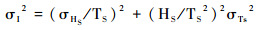
此处为HS是累积下切量,上界是河流阶地的基座面高度;TS是累积下切时间,也就是河流阶地基座的形成时间。下切速率的不确定性σI的计算公式为:
|
此处σHS是累积下切量的不确定性,σTS是累积下切时间的不确定性。
基于上述讨论可知,计算河流下切速率的累积下切量,上界位置是河流阶地冲洪积物与基岩基座界线、下界位置是现代基岩河道[64, 67](图 4)。由于加积过程或者滑坡等原因河道堵塞而发生侧向迁移,河流并不是沿着古河道下切冲洪积物,通常情况是下切谷壁[65, 68],因此,河流阶地的基座与上覆冲洪积物之间界线不平整,不同位置测到的拔河高度多为上限值。此外,后期坡积过程改造以及植被覆盖,或者因为地势陡峭、无道路通达,野外无法准确识别基岩与沉积物界线(图 4b)。现代基岩河道一些河段可能覆盖厚层冲洪积物,例如从钻井数据获得雅鲁藏布江大河谷上游河段覆盖超过500 m厚河谷充填物[69]、金沙江虎跳峡上游河谷充填物达到250 m[70]。因为大多数情况下无法获得现代河道基岩之上冲洪积物的具体厚度,假定现代河水位置为当前河道基座的位置,这样获得的基座拔河高度通常为最小值(图 4c)。计算河流下切速率时,考虑上述这些情况,将赋予计算的基岩基座高度一定的误差值、通常约为10% [62, 66]。

|
图 4 重建河流阶地累积下切量的4种情况(引自Burbank和Anderson[1]) Fig. 4 Four types of how to reconstruct the cumulative incision amount of fluvial terraces, quoted from Burbank and Anderson[1] |
最新研究指出河流下切速率是不稳定的,随着累积下切时间的增长,河流下切速率变小[71~72]。Gallen等[72]认为基岩下切和阶地的形成涉及到侵蚀和加积作用的交替发生,伴随着河床高度的持续波动[62, 73~74],而实际计算下切速率时以当前河床高度作为累积下切量的下界,导致河流下切速率值呈现与累积下切时间有关的非稳态问题(图 4d)。鉴于此,Gallen等[72]建议校正河流下切速率偏差的方法是将最低、最年轻并且有测年数据的河流阶地作为下界计算累积下切量,相应的下切时间的差值作为累积下切时间来计算河流下切速率。
野外可通过如下方法测定河流阶地的高度:1)手持GPS:需要实际到达测量位置测定经纬度以及海拔高度,水平误差3~5 m、垂向误差约10 m;实际操作困难之处在于,最佳测量点因为地势起伏大、深沟等原因而无法到达;2)激光测距仪:有效量程范围内,远距离测定目标位置之间的垂向高度差;但可能因为超出激光测距仪的水平测程,或者目标物的物理特性导致激光散射(如茂密植被覆盖)无法正常返回完成测量;3)地基LiDAR:对河流阶地进行高精度地形扫描,获得厘米级别精度的相对位置,尤其是地势落差大并且流水湍急地区,有效量程为1.4 km或4 km;此方法的难点在于大面积、地势起伏大的阶地需要多点测量,野外工作量大并且数据拼接挑战性大;4)无人机摄影测量:实现正射和4个方向45°斜射拍照,利用Agisoft PhotoScan实现三维地形数据重建,获得多个位置的影像以及经纬度和高程信息;在实际操作过程中需注意设计好飞行区域、起飞位置和飞行高度,避免深沟信号遮挡,确保小飞机安全飞行。
计算河流下切速率,需要测定河流阶地的基座形成时间,也就是河流侧向切割谷壁形成宽阔平台的时间。对于无沉积物覆盖的基座阶地,可以直接测定基岩的废弃时间,可选择的测年方法为宇宙成因核素暴露定年、测试对象为含石英的基岩[75];对于上覆不同厚度冲洪积物的河流阶地,最佳采样对象是靠近基岩基座、代表切割基座平台的河流相层序,可选择的埋藏定年方法包括碳十四、光释光以及宇宙成因核素埋藏定年等[49, 62, 65, 75~76]。对于上覆薄层冲洪积物的基座阶地(< 5 m),阶地面的废弃时间和基座形成时间差别不大,可选择宇宙成因核素暴露定年方法,测试对象为阶地面的小砾石集合、巨砾表面样、或者深度剖面[75];对于上覆厚层冲洪积物的河流阶地,基座上覆河流相砾石层的埋藏时间与阶地面的废弃时间差别显著。笔者对藏东南澜沧江流域河流阶地的研究发现[77],约150 m基座上覆约100 m的河流相砾石层,靠近基岩河流相砾石层中的透镜状砂体的光释光定年结果为90 ka,而阶地面顶部宇宙成因核素暴露定年时间为50 ka,因此基座上覆河流相沉积的埋藏时间能更好地约束基座的形成时间。鉴于上述原因,计算河流下切速率时,优先选择基座上覆冲洪积物的沉积埋藏时间。需要注意的是,不同测年方法对采样对象和采样条件具有特定要求,导致大多数情况下测年样品采集层位距离基岩基座不同的高度,因此测得的沉积埋藏时间为基岩基座形成时间的下限,相应地计算获取的是河流下切速率的最大值。
3 测年方法 3.1 碳十四碳十四(14C,Carbon-14)是比较成熟的定年方法,精度相对较高(1% ~5%)。14C原子的半衰期为5730 a,正常情况下这种测年方法的上限大概为45000 a。大气层上部,宇宙射线产生的中子与大气中的氮核发生核反应,生成大气14C,之后快速氧化成二氧化碳,通过植物光合作用和动物对食物的摄取而进入生物圈。生物活着的时候由于新陈代谢而与大气中14C浓度保持大体平衡,一旦动物或植物死亡后停止与大气交换,其体内的14C浓度开始随着时间衰减,根据样品中测定的14C含量可以测定生物体的死亡时间,进而测定相应沉积物的埋藏时间。因此,碳十四测年的对象包括阶地沉积物内保存的一系列生物成因的物质,包括落叶层、木头、植物大化石、木炭和泥炭。需要指出的是,一些碎屑有机物质为搬运再沉积物质,测定的碳十四年龄具有继承性,是相应阶地沉积物埋藏时间的上限值。由于含碳有机物质相对沉积物密度小但体积大,因此常出现在细粒沉积物中,寻找碳样时注意重点查找。采集碳样需要准备三角型小铲刀以及削铅笔用的小刀,前者用来逐层刮看沉积物寻找碳样,采集碳样放置低处接住样品并去除多余沉积物,后者用来准确采集碳样。采集样品应装入锡箔纸叠制的样品袋,不可装入布袋或者用纸包装、并且不可将纸质标签放入样品中。潮湿的样品不可长时间常温储存,防止发霉、导致现代碳污染,应尽快送到实验室进行测试。
3.2 光释光定年光释光定年(Optically Stimulated Luminescence,简称OSL)是释光定年的一种,将样品暴露在特定波长的日光下,仅放出对光敏感的释光信号。相比较其他测年方法,光释光在研究地表过程方面的优势在于:1)光释光对环境条件非常敏感,日光能在数秒内擦除信号;2)通常使用的矿物石英和长石在地表环境普遍存在;3)有效测年范围在数年到十万年,应用的地质环境广泛[78]。实验室通过测定石英等矿物天然OSL信号强度所对应的电离辐射剂量即等效剂量(ED)或者和环境剂量率(D)来获得埋藏年龄t,简要表示如下:

|
对小于5万年样品,进行粗颗粒石英单片再生剂量法测定等效剂量;而对于大于5万年的沉积物的OSL测年,进行细颗粒石英多片再生剂量法;对于超过10万年的样品,可以选择长石进行测年[79~81]。光释光定年的准确度取决于沉积之前样品的曝光情况,这受控于样品沉积之前搬运过程中曝光的强度和持续时间。石英颗粒的起源和地质历史也很重要:最新从基岩侵蚀下来的样品比经历多次沉积循环的样品曝光困难[78]。通常从漫滩相细粒物质或者河流相砾石层中夹有的透镜体状砂体采集光释光样品,目标层岩性比较均一、厚度最好超过30 cm,保证周边环境剂量率的一致。光释光实验需要的粒径主要是4~11 μm(细粒)和90~180 μm(粗粒),所以选择的目标砂层为细砂-粉砂。另外砂层的分选性和磨圆要好,确保样品充分曝光。建议野外携带10倍放大镜,采样之前将样品层放大来看分选性和磨圆度、以及石英的含量。
采样前需要准备采样钢管,一般情况下钢管内部直径不超过5 cm、长度25 cm左右。野外注意根据采样层厚度和水平连续性选择钢管尺寸,如果样品的空间连续性不好但样品比较重要,建议可以制作内直径小并且短的钢管,例如直径3 cm、长度20 cm,野外采集样品的时候可以采集2根或者更多样品。实验室处理样品时,将去除两端3~5 cm左右、采样过程中可能曝光的部分。用塑料自封袋收集钢管两侧15 cm范围内的沉积物,采集约500 g用来测定环境剂量率。
3.3 宇宙成因核素暴露和埋藏定年通过测量持续暴露在宇宙射线轰击的地表岩石中宇宙成因核素的累积量,来计算地表的曝露年龄,最常使用的宇宙成因核素为10Be。宇宙成因核素在地表的生成速率随高度和纬度发生变化,地表之下生成速率随着深度幂次下降、超过95%的宇宙成因核素形成于最上部2 m深度[82]。一般来说,宇宙成因核素暴露年龄可以通过测定宇宙成因核素的浓度和特定矿物中局部生成速率而得到,然而准确测定暴露定年需要测定如下参数:首先,必须解释沉积之前的宇宙成因核素组分,否则计算的暴露年龄太老;其次,沉积之后地貌面的改造需要仔细评估,因为如果不考虑,测定的暴露年龄太年轻。对于无冲洪积物覆盖、可见流水冲刷痕迹的基岩基座,可以直接采集富含石英的基岩[36, 75, 83];对于上覆一定厚度冲洪积物的河流阶地,可选择的采样方法包括:1)采集50件以上小砾石(粒径 < 3 cm),同时采集现代河道相当数量的小砾石来限定继承核素浓度,假定河流阶地的砾石埋藏前经历了与现代河道小砾石类似的暴露历史而具有相似的宇宙成因核素浓度;采集小砾石代表阶地面形成时的沉积物(具有一定磨圆度),寻找阶地面相对平坦位置,远离局部冲沟、高阶地坎影响。2)采集深度剖面样品,地貌面之下约2 m深度,20~50 cm间隔采集6~7层样品,通常是顶部采样相对密集、底部稀疏,优先采集含石英的沙,其次是> 50个含石英小砾石(< 3 cm)[42, 84~85],因为粒径不同记录不同的搬运-沉积历史,粒径越小,更能有效平均继承性核素浓度,最后可使用Monte Carlo模拟测定暴露年龄以及顶面侵蚀速率[86]。3)阶地面出露的含石英巨砾5~7件,采集表面3~5 cm,一般认为巨砾的继承性浓度低,但是无法排除后期被覆盖的情况,因此获得年龄为下限值,采集多件样品做加权平均值。
宇宙成因核素埋藏定年利用10Be和26Al半衰期的差异(分别为1.4 Ma和0.7 Ma)来测定沉积物埋藏时间,有效测年范围为0.2~4.0 Ma[54]。基本假设是:1)沉积物埋藏足够深以至于能够避免明显的埋藏后核素的形成;2)埋藏之前具有简单的曝露历史,最好长期的曝光历史达到稳态的核素浓度。埋藏之后,核素浓度因为衰变而下降,26 Al比10Be衰减的快,而26Al/10Be地表生成速率比值为6.75[54],可以通过测定样品中两种核素的浓度来计算埋藏年龄。这种测年方法需要采样剖面至少10 m,原则上单个样品可以测定沉积物的年龄。等时线法是宇宙成因核素埋藏定年的变种,可以用于浅埋藏和/或后期剥蚀过程中经历明显后埋藏生成的沉积物,需要几件来自同一地层层位的样品来建立等时线[54]。与简单埋藏方法不同,等时线法不需要深度、暴露时间、或者埋藏后宇宙成因核素的形成信息;相反,需要同一深度采集多件含石英的样品,包括不同岩性和/或磨圆度的大砾石、小砾石集合(< 3 cm)、或者砂层。采样的基本原则是,一方面样品尽可能经历不同的埋藏前暴露历史,包括山坡侵蚀剥露、短暂沉积存储以及长距离河流搬运等过程,因此具有不同的宇宙成因核素继承浓度[54, 87~88];另一方面这些样品具有相同的埋藏后的宇宙成因核素的衰变过程,同时需要足够厚度的沉积盖层(至少5 m),尽量降低埋藏之后生成宇宙成因核素26Al和10Be的生成。通过测定相同层位几件样品的10Be和26Al浓度,可以模拟埋藏后组分,计算埋藏时26Al/10Be的比率。为确保宇宙成因核素埋藏时间最好代表阶地形成时间,用作测年的样品采样层位尽量靠近基岩基座。
4 河流阶地与下切速率河流阶地及其相关的沉积保存着河流沉积、水动力以及侵蚀等方面数百-数十万年时间的历史,结合第四纪测年方法,可以重建河道的加积和下切历史,获得河流下切速率的重要信息。因此,河流阶地用来研究不同时间和空间尺度上构造、地表过程和气候之间相互作用等地貌问题[89~93],而且新构造运动的研究也经常使用河流阶地作为变形和抬升的被动标志[67, 94~96]。
河流侧向侵蚀谷壁形成平坦面,之后垂向下切废弃这些地貌面形成阶地面[74, 97~98],因此河流阶地的形成条件是垂向下切/侧向侵蚀比率的增加,通常是垂向下切速率的增加[74, 99~100],外部因素包括构造[101~103]、基准面变化[104~106]以及更常见的气候变化造成的水和沉积物通量的变化[67, 74, 98~99, 107~108]。除此之外,研究表明即使稳定下切,河流的侧向迁移和曲流的截断也可以形成河流阶地[109]。
构造抬升改变局部河道梯度,相应地影响河流的水动力条件而导致河流行为的改变。用河流下切速率获得岩石抬升速率的基本条件是:经过足够大的空间和足够长的时间尺度,河流发展调整到稳态剖面,也就是沿着整个河道河流下切速率与岩石抬升速率达到平衡状态。鉴于此,河流剖面可以作为测定岩石抬升的基准,河流下切速率可以通过测定局部基座面与现在基岩河道之间的高度差来获得。需要注意的是,我们测量基座高度、忽略河流切割上覆充填物的厚度,原因是假定河谷每次形成基座时都返回相同的河流纵剖面或比降,岩石抬升相当于基岩下切量,而不是总下切量,基本假设是河流阶地基座形成与当前河流切割基岩处在相似的水动力条件之下,这两阶段形成的河流纵剖面相似[62]。Lavé和Avouac[65]获得了流经尼泊尔喜马拉雅造山带的一系列横向河流的下切速率及其空间分布,并证实该地区主喜马拉雅逆冲断层具有断坪-断坡的几何学形态(flat-ramp geometry)。在华盛顿州中部与断层有关的Yakima褶皱带,Bender等[110]发现背斜位置基座阶地获得的下切速率是向斜位置以及褶皱带之外阶地获得的下切速率的4~8倍,进而计算了第四纪岩石抬升差异导致的基岩下切速率,以及该构造位置分配的区域缩短速率[64~65, 67]。
事实上,河流剖面的波动性很大,河道不断调整着气候波动造成的河流流量和沉积物载荷的变化,同时受基准面变化以及构造抬升等外部扰动,因此局部的河流下切不一定代表构造抬升。一方面,河流阶地基座的形成并非短期的瞬时现象,可以包含在长期准平衡的河道剖面[111],由现代河道剖面的梯度代表。基座阶地可以形成于不同下切速率的山区,在小于1 mm/a的地区常成对且广泛发育,在高达约10 mm/a的快速抬升地区[36, 112],阶地很少成对并且向下游方向发育范围有限(< 1 km)。另一方面,气候变化造成河流下切的空间范围和量级实际上有可能远远超过构造和岩石抬升的作用。Poisson和Avouac[113]发现天山北麓河流全新世以来下切量达到300 m,生长背斜处的构造抬升仅能解释局部下切量的10%,因此大部分河流下切是全新世早期较湿润气候条件下水动力体系动态调整的结果,当时流量是现在的3倍,超过沉积物供应量。
尽管河流阶地位于现代河谷之上不同高度,但是它们的年龄相对集中在已知的某些气候变化对应的时段,促使地貌学家将气候变化的影响作为河流阶段性下切的主要控制因素[36, 64~65, 99, 114~117]。但因为测年精度的限制,截至目前为止尚且无法确定阶地年龄和古气候记录之间的关系[67],对于基座阶地更大的不确定性在于基座切割和上覆冲洪积物沉积之间的时间差[99]。一方面不同的学者发现河流阶地形成于冰盛期[107, 115],或冰期到间冰期的转变[116]、或者间冰期[118];另一方面,与气候变化有关的冲洪积阶地河谷,所发育河流阶地的级数和气候周期之间没有一一对应关系[98]。河流阶地形成时间的变化之大可能归因于河流阶地距离冰川的距离,以及冰川地区和非冰川地区影响沉积物搬运到河流的地表过程。定量评估气候对地貌的影响仍然是巨大挑战,一方面尚不清楚过去气候变化对地貌的影响;另一方面,不清楚特定的气候过程,例如沉积物供应量、降水强度以及峰值流量的变化,如何导致河流阶地的形成,以及这些气候作用达到怎样强度才能形成河流阶地[100, 119]。
以科罗拉多大峡谷为例,新生代晚期大峡谷的地貌演化受到3次重要构造和水系调整事件影响[120~121]。首先,Grand Wash-Wheeler断层体系的活动形成约1 km的地形高差,河流开始发育,开始时间为约16.5 Ma;第二,5.5~6.0 Ma之间,先成的科罗拉多河与科罗拉多河下游通过大峡谷连通;第三,科罗拉多河受到Hurricane和Toroweap断层上新世-第四纪活动的影响。尽管这些事件有相对可靠的时间约束,但是大峡谷区域河流下切速率在时间上是如何变化、沿着河流剖面在空间上如何变化仍不确定。一方面,基于河流阶地[122~123]、钙华沉积[124]、玄武岩熔岩流[122, 125]等测定的上新世-第四纪下切速率低于新生代晚期下切速率[122]。断裂的构造作用和河流下切二者之间关系尚未清晰厘定,在于涉及到地貌过程的复杂性,包括基岩河道侵蚀、陡崖后退、侵蚀卸载造成的挠曲反弹响应,以及这些过程与上新世-第四纪正断层之间相互作用。Pelletier[126]针对该问题对大峡谷新生代晚期地貌演化进行数值模拟,定量研究这些复杂地貌过程,选用最近下切速率的详细信息来更好地理解基岩主导的河流体系更长期的地貌演化过程。另一方面,4.0~0.5 Ma期间,大峡谷东部下切速率为大峡谷西部的2~3倍[127]。一种解释是Hurricane和Torowep断层的相对沉降,导致西部下切速率低[122];另一种解释是,大峡谷有迁移的裂点带通过,特点是高速率下切[128]。争论一直得不到解决的原因是大峡谷中部缺少下切速率数据、大峡谷东部下切间隔短(385 ka)。Abbott等[124]获得大峡谷东部和中部500 ka以来的切割历史,测年方法是泉华胶结阶地沉积物的U/Th年龄测定,揭示大峡谷东部500~400 ka下切速率为1~4 mm/a,之后至少下降了5倍,并将其归结为裂点带的瞬时通过。这样来看,详细获得长时间尺度和广泛空间范围内精细分辨率的河流下切速率信息,开展基于地表过程的数值模拟,是更好解析河流阶地保存的构造、气候和地表过程之间相互作用具体内涵的重要途径。
5 不同时间尺度侵蚀速率对比为理解地貌演化及其与构造、气候的相互作用,需要运用多种方法来获得不同空间和时间尺度的侵蚀速率。除了河流阶地获得的下切速率,还包括低温热年代和宇宙成因核素等方法获得的侵蚀速率。低温热年代学方法主要包括磷灰石和锆石裂变径迹以及(U-Th)/He等测年手段,封闭温度约70~250 ℃,相当于地表之下3~10 km深度,有效时间尺度为若干百万年[1]。多种矿物体系获得热年代数据可以获得有意义的侵蚀速率的变化,而且提供目前测年手段能获得的最好的百万年时间尺度的平均侵蚀速率。将低温热年代学方法获得的年龄数据转化为侵蚀速率时遇到的问题是:无法获得可靠的局部地温梯度,因此通常假定地温梯度为20~30 ℃/km。然而岩石抬升和热液流体的运移以及地形的起伏,均可以扰动局部地温梯度。冷却过程中局部地温梯度的不确定性,导致从热冷却历史获得的侵蚀速率具有相当大的不确定性。宇宙成因核素方法通过测定现代河沙中核素浓度获得流域的平均侵蚀速率,测试有效时间尺度通常为数千年[129~130],基本假设之一是流域内侵蚀速率均一。对于处于瞬时状态的集水盆地,河流对外部扰动的敏感程度明显高于山坡,通常具有更高的侵蚀速率,获得的侵蚀速率为大面积、低侵蚀速率的山坡与小面积、高侵蚀速率的面积加权平均值。对比不同时间尺度获得的侵蚀速率时,存在3种不同情况:1)3种侵蚀速率大体一致;2)随着时间尺度变小而增大;3)中间时间尺度增大。
有研究发现,在某些构造环境下不同时间尺度的侵蚀速率一致[131~135],支持这些造山带在约103~106 a时间尺度上达到了均衡状态。意大利Apennines山脉北部和中部地区,使用宇宙成因核素方法获得的流域平均侵蚀速率和古侵蚀速率以及河流下切速率为0.20~0.58 mm/a,与沉积物通量(0.12~0.44 mm/a)、河流下切速率(0.35 mm/a)、以及抬升速率(0.01~0.10 mm/a)大体一致[131]。这表明该地区在约1 Ma以来达到均衡状态,山坡侵蚀速率和河流下切速率能够平衡局部的抬升速率(图 5)。但是这些地貌变化速率明显低于低温热年代学获得的约4.5 Ma以来约1.2 mm/a的侵蚀速率,因此约4.5~1.0 Ma之间该地区地貌处于瞬时状态[131]。

|
图 5 意大利Apennines山脉北部和中部(a)以及不同方法获得的地貌侵蚀速率(b)引自Cyr和Granger[131] Fig. 5 Landscape erosion rates(b) acquired by various methods for the northern and central Appennines mountains in Italy(a), quoted from Cyr and Granger[131] |
Finnegan等[71]提出河流下切速率在约104~107 a时间尺度上呈现瞬时性,随着测量间隔的增大、包含更长时间的下切间断(包括加积过程以及既不加积也不下切的过程),因此下切速率明显下降;相反地,相对短的测量间隔,计算的下切速率明显变大(图 6)。我们注意到下切间断与冰期和间冰期旋回并不是简单的一一对应关系,因此二者相关性不止局限于第四纪时期、达到百万年时间尺度。青藏高原东缘长江流域虎跳峡地区,对洞穴沉积物开展的宇宙成因核素埋藏定年工作发现,约13~9 Ma之间河流下切的速率为约0.3 mm/a,而约9 Ma之后河流下切速率仅为约0.05 mm/a,存在几个百万年的河流下切间断[136]。宇宙成因核素获得流域平均侵蚀速率,已有研究发现短测量间隔内,因为包含更少的灾难性侵蚀事件而导致侵蚀速率明显下降[71, 133]。

|
图 6 无序的冲洪积河床高度变化、累积河流下切量和下切速率之间关系(引自Finnegan等[71]) (a)假定下切速率恒定,冲洪积河床高度(黑色实线)和累积河流下切量(绿色虚线)的随机分布模拟;(b)累积下切量(绿色虚线)和平均下切速率(蓝色实线)的对数值投图 Fig. 6 The connection between stochastic alluvial bed elevation change, cumulative bedrock incision and incision rate, quoted from Finnegan et al.[71]. (a)Random-walk simulation of alluvial bed elevation(black line)and cumulative bedrock incision(dashed green line), assuming incision rate is constant when the bed is unburied. (b)Plot of the logarithm of cumulative incision(dashed green line)and the logarithm of time-averaged incision rate(solid blue line) |
笔者对藏东南澜沧江流域的河流阶地开展了系统地光释光定年工作,获得从千年到十万年的河流下切速率在0.5~2.8 mm/a[77],比低温热年代学和宇宙成因核素两种方法测得的侵蚀速率的高出一个量级(图 7)。低温热年代学结果发现,在百万年时间尺度上,澜沧江流域河谷顶部的侵蚀速率为约0.1~0.3 mm/a,而谷底的侵蚀速率为约0.4~1.0 mm/a[137~138];澜沧江主干和支流河沙的10Be浓度获得的千年时间尺度上流域平均侵蚀速率为约0.2~0.6 mm/a[139]。以上这3种方法获得的侵蚀速率的不同,表明反映山坡响应外部扰动滞后于最近加速下切的主干河流下切。一方面,河流阶地测得的下切速率比低温热年代学获得的侵蚀速率快,表明主干河流下切比山坡侵蚀快;另一方面,更长时间尺度上,澜沧江谷底的侵蚀速率比谷顶侵蚀速率快[137~138]。此外,宇宙成因核素浓度获得的流域平均侵蚀速率低于河流下切速率,因为该侵蚀速率是大面积低侵蚀速率高地与小面积高侵蚀的河谷的空间分布加权的结果。

|
图 7 藏东南澜沧江流域不同方法获得的侵蚀速率引自Zhang等[77] Fig. 7 Various kinds of erosion rates along the Lancang River in southeast Tibet, quoted from Zhang et al.[77] |
河流下切引导着活动造山带侵蚀作用的步伐,因此下切速率及其时间和空间分布样式是解析构造、地表过程和气候变化之间广泛相互作用的关键切入点之一。计算河流下切速率时,累积下切量上界是基岩基座,下界最优选择是低级阶地基岩基座,其次是当前基岩河道,而累积下切时间的最佳约束是靠近基岩基座的冲洪积物的埋藏时间。综合考虑河流阶地基岩基座高度、上覆沉积物厚度、沉积物类型以及河流阶地面等情况,选择合适的第四纪测年方法,主要包括碳十四、光释光、宇宙成因核素暴露和埋藏定年等。实际工作中注意河流阶地保存的不完整性,需要用其他方法获得阶地未保存阶段河流的下切速率,例如基于河道底部流水施加的剪应力估计河流下切速率[65]。河流下切的标志面不止是过去宽阔的河道,也包括其他地貌标志,最典型的是喀斯特地区保存在不同拔河高度的洞穴或暗河里的河流相沉积物[136, 140]。除文中介绍的3种主要的第四纪测年方法,需要综合运用其他测年方法,拓展测年沉积物类型、延长河流下切速率的有效时间范围以及相应的时间分辨率。一方面,将古地磁测年、火山灰Ar-Ar测年以及泉华U系测年方法引入河流阶地的研究工作[116, 124~125, 141],另一方面囊括多种同位素体系,将宇宙成因埋藏测年的范围扩展到十几个百万年[136]。
基于河流下切速率解析构造活动速率时,基本假设是河流下切速率与构造抬升速率达到均衡。需要注意的是,一方面河流下切的间断可以达到上百万年,使得河流下切速率偏离岩石抬升速率,河流剖面处于瞬时状态;另一方面,气候变化造成的河流下切的空间范围和量级可能远超过岩石抬升的影响。野外工作时,注意调查活动构造的空间展布和活动历史、区域气候变化情况以及河流阶地类型和空间分布情况。河流的加积与下切作用与第四纪气候变化存在时间上相关性,但是受测年方法和测试精度的限制,尚且无法确定二者之间一一对应关系。实际工作中需要从空间展布以及与水动力和沉积物供应量有关的地表过程,来具体评估河流行为的转换与第四纪气候波动之间的相关性。基于河流阶地计算所得的河流下切速率,与基于低温热年代学和宇宙成因核素数据获得的侵蚀速率进行比较,可以衡量地貌演化步伐、达到均衡状态或者处于瞬时状态。河流下切不稳定性导致的下切速率,甚至侵蚀速率的瞬态性以及河流和山坡体系对外部扰动响应敏感度的差异性,使得不同时间和空间尺度侵蚀速率无法进行直接对比和分析。
不同的地貌演化模型(例如CHILD)能够提供特定的物理条件之下,山脉、山坡或者河道如何定量响应不同类型的构造和气候变化等外部扰动[1, 73, 142~143]。随着计算机运算性能的迅猛发展,构造地貌学家不断使用地貌演化的数值模拟来探究构造、气候、和地表过程之间复杂的相互作用[143~144]。实际工作中,需要尽可能详细收集不同时间和空间尺度上构造、气候和侵蚀速率的量级和分布样式,借助基于过程的地貌数值模拟程序,定量解析构造、气候和地表过程之间的广泛相互作用,并高效地指出现有地貌研究的薄弱部位以及重点工作方向。
致谢 审稿专家及《第四纪研究》编辑部的老师们对本文的修改提出了许多宝贵意见,在此致以真诚的谢意!
| 1 |
Burbank D W, Anderson R S. Tectonic Geomorphology (Second edition). West Sussex: Willey-Black Well, 2011: 1-444.
|
| 2 |
Beaumont C, Jamieson R A, Nguyen M H et al. Himalayan tectonics explained by extrusion of a low-viscosity crustal channel coupled to focused surface denudation. Nature, 2001, 414(6865): 738-742. DOI:10.1038/414738a |
| 3 |
Beaumont C, Jamieson R A, Nguyen M H et al. Crustal channel flows:1. Numerical models with applications to the tectonics of the Himalayan-Tibetan orogen. Journal of Geophysical Research:Solid Earth, 2004, 109(B6): B06406. |
| 4 |
Hodges K, Hurtado J, Whipple K. Southward extrusion of Tibetan crust and its effect on Himalayan tectonics. Tectonics, 2001, 20(6): 799-809. DOI:10.1029/2001TC001281 |
| 5 |
Koons P, Zeitler P, Chamberlain C et al. Mechanical links between erosion and metamorphism in Nanga Parbat, Pakistan Himalaya. American Journal of Science, 2002, 302(9): 749-773. DOI:10.2475/ajs.302.9.749 |
| 6 |
Molnar P, England P. Late Cenozoic uplift of mountain ranges and global climate change:Chicken or egg?. Nature, 1990, 346(6279): 29-34. DOI:10.1038/346029a0 |
| 7 |
Whipple K X. The influence of climate on the tectonic evolution of mountain belts. Nature Geoscience, 2009, 2(2): 97-104. DOI:10.1038/ngeo413 |
| 8 |
Zeitler P K, Koons P O, Bishop M P et al. Crustal reworking at Nanga Parbat, Pakistan:Metamorphic consequences of thermal-mechanical coupling facilitated by erosion. Tectonics, 2001, 20(5): 712-728. DOI:10.1029/2000TC001243 |
| 9 |
Champagnac J D, Molnar P, Sue C et al. Tectonics, climate, and mountain topography. Journal of Geophysical Research:Solid Earth, 2012, 117(B2): B02403. |
| 10 |
Harrison T M, Copeland P, Kidd W et al. Raising Tibet. Science, 1992, 255(5052): 1663-1670. DOI:10.1126/science.255.5052.1663 |
| 11 |
Guo Z, Ruddiman W F, Hao Q et al. Onset of Asian desertification by 22 Myr ago inferred from loess deposits in China. Nature, 2002, 416(6877): 159-163. DOI:10.1038/416159a |
| 12 |
Molnar P, Boos W R, Battisti D S. Orographic controls on climate and paleoclimate of Asia:Thermal and mechanical roles for the Tibetan Plateau. Annual Review of Earth and Planetary Sciences, 2010, 38: 77-102. DOI:10.1146/annurev-earth-040809-152456 |
| 13 |
Roe G H, Montgomery D R, Hallet B. Effects of orographic precipitation variations on the concavity of steady-state river profiles. Geology, 2002, 30(2): 143-146. DOI:10.1130/0091-7613(2002)030<0143:EOOPVO>2.0.CO;2 |
| 14 |
Wang C, Dai J, Zhao X et al. Outward-growth of the Tibetan Plateau during the Cenozoic:A review. Tectonophysics, 2014, 621: 1-43. DOI:10.1016/j.tecto.2014.01.036 |
| 15 |
李吉均, 方小敏, 潘保田等. 新生代晚期青藏高原强烈隆起及其对周边环境的影响. 第四纪研究, 2001, 21(5): 381-391. Li Jijun, Fang Xiaomin, Pan Baotian et al. Late Cenozoic intensive uplift of Qinghai-Xizang Plateau and its impacts on environments in surrounding area. Quaternary Sciences, 2001, 21(5): 381-391. |
| 16 |
Grujic D, Coutand I, Bookhagen B et al. Climatic forcing of erosion, landscape, and tectonics in the Bhutan Himalayas. Geology, 2006, 34(10): 801-804. DOI:10.1130/G22648.1 |
| 17 |
Tomkin J H, Roe G H. Climate and tectonic controls on glaciated critical-taper orogens. Earth and Planetary Science Letters, 2007, 262(3): 385-397. |
| 18 |
Meade B J, Conrad C P. Andean growth and the deceleration of South American subduction:Time evolution of a coupled orogeny-subduction system. Earth and Planetary Science Letters, 2008, 275(1): 93-101. |
| 19 |
Herman F, Seward D, Valla P G et al. Worldwide acceleration of mountain erosion under a cooling climate. Nature, 2013, 504(7480): 423-426. DOI:10.1038/nature12877 |
| 20 |
Council N R. New Research Opportunities in the Earth Sciences at the National Science Foundation. Washington, DC: National Academies Press, 2012: 1-216.
|
| 21 |
张会平, 张培震, 郑德文等. 祁连山构造地貌特征:青藏高原东北缘晚新生代构造变形和地貌演化过程的启示. 第四纪研究, 2012, 32(5): 907-920. Zhang Huiping, Zhang Peizhen, Zheng Dewen et al. Tectonic geomorphology of the Qilian Shan:Insight into the Late Cenozoic landscape evolution and deformation in the north eastern Tibetan Plateau. Quaternary Sciences, 2012, 32(5): 907-920. |
| 22 |
刘静, 陈涛, 张培震等. 机载激光雷达扫描揭示海原断裂带微地貌的精细结构. 科学通报, 2013, 58(1): 41-45. Liu Jing, Chen Tao, Zhang Peizhen et al. Illuminating the active Haiyuan Fault, China by Airborne Light Detection and Ranging. Chinese Science Bulletin, 2013, 58(1): 41-45. |
| 23 |
苏琦, 袁道阳, 谢虹等. 祁连山西段党河流域地貌特征及其构造指示意义. 第四纪研究, 2015, 35(1): 48-59. Su Qi, Yuan Daoyang, Xie Hong et al. Geomorphic features of the Danghe River drainage basin in western Qilian Shan Mountain and its tectonic implications. Quaternary Sciences, 2015, 35(1): 48-59. |
| 24 |
王朋涛, 邵延秀, 张会平等. sUAV摄影技术在活动构造研究中的应用——以海原断裂骟马沟为例. 第四纪研究, 2016, 36(2): 433-442. Wang Pengtao, Shao Yanxiu, Zhang Huiping et al. The application of sUAV photogrammertry in active tectonics:Shanmagou site of Haiyuan fault, for example. Quaternary Sciences, 2016, 36(2): 433-442. |
| 25 |
姜大伟, 张世民, 丁锐等. 龙门山南段前陆区古冲积扇分析及河流地貌面序列的建立——基于地貌面的测年数据、野外地貌分析与调查. 第四纪研究, 2016, 36(5): 1263-1279. Jiang Dawei, Zhang Shimin, Ding Rui et al. A fluvial morphologic surface sequence based on the research of alluvial fans in the forland region of southern Longmen Shan-According to the dating methods, field survey, and geomorphological analysis. Quaternary Sciences, 2016, 36(5): 1263-1279. |
| 26 |
李小强, 王军, 熊仁伟等. 六盘山地区河道陡峭指数对隆升速率差异的响应. 第四纪研究, 2016, 36(2): 443-452. Li Xiaoqiang, Wang Jun, Xiong Renwei et al. The response of the channel steepness index to the difference of uplift rate in the Liupanshan Mountain area. Quaternary Sciences, 2016, 36(2): 443-452. |
| 27 |
肖萍, 刘静, 王伟等. 青藏高原东南缘芒康地区河流地貌演化的磷灰石U-Th/He记录. 第四纪研究, 2015, 35(2): 433-444. Xiao Ping, Liu Jing, Wang Wei et al. The evolution of fluvial geomorphology of Mangkang area (southeastern Tibetan Plateau) recorded by apatite U-Th/He thermochronology. Quaternary Sciences, 2015, 35(2): 433-444. DOI:10.11928/j.issn.1001-7410.2015.02.18 |
| 28 |
郑德文, 武颖, 庞建章等. U-Th/He热年代学原理、测试及应用. 第四纪研究, 2016, 36(5): 1027-1036. Zheng Dewen, Wu Ying, Pan Jianzhang et al. Fundamentals, dating and application of U-Th/He thermochronology. Quaternary Sciences, 2016, 36(5): 1027-1036. |
| 29 |
吕延武, 顾兆炎, 许冰等. 云南怒江丙中洛河段第三级阶地10Be暴露年龄. 第四纪研究, 2012, 32(3): 403-408. Lu Yanwu, Gu Zhaoyan, Xu Bing et al. 10Be dated boulders from the third terrace of Nujiang River at Bingzhongluo, Yunnan Province, China. Quaternary Sciences, 2012, 32(3): 403-408. |
| 30 |
黄湘通, 郑洪波, John Chappell等. 长江流域河流沉积物宇宙成因核素10Be特征与侵蚀速率估算. 第四纪研究, 2013, 33(4): 671-683. Huang Xiangtong, Zheng Hongbo, John Chappell et al. Characteristics of cosmogenic nuclide 10Be in the Yangtze Riverine sediments and estimations of erosion rate. Quaternary Sciences, 2013, 33(4): 671-683. |
| 31 |
韩非, 陈杰, 尹功明. 西域砾岩宇宙成因核素26Al/10Be埋藏定年探索. 第四纪研究, 2015, 35(1): 109-117. Han Fei, Chen Jie, Yin Gongming. Cosmogenic nuclides 26Al/10Be burial dating of Xiyu Conglomerate. Quaternary Sciences, 2015, 35(1): 109-117. |
| 32 |
韩非, 顾兆炎, 尹功明等. 宇宙成因核素26Al/10Be埋藏测年法在宁夏沙坡头黄河砾石阶地年代研究中的应用. 第四纪研究, 2016, 36(5): 1216-1223. Han Fei, Gu Zhaoyan, Yin Gongming et al. Cosmogenic nuclides 26Al/10Be burial dating of Yellow River gravel terraces around Yemingshan Hill, Ningxia, China. Quaternary Sciences, 2016, 36(5): 1216-1223. |
| 33 |
Whipple K X, Tucker G E. Dynamics of the stream-power river incision model:Implications for height limits of mountain ranges, landscape response timescales, and research needs. Journal of Geophysical Research:Solid Earth, 1999, 104(B8): 17661-17674. DOI:10.1029/1999JB900120 |
| 34 |
Whipple K X. Fluvial landscape response time:How plausible is steady-state denudation?. American Journal of Science, 2001, 301(4-5): 313-325. DOI:10.2475/ajs.301.4-5.313 |
| 35 |
Whipple K X. Bedrock rivers and the geomorphology of active orogens. Annual Review of Earth Planetary Sciences, 2004, 32: 151-185. DOI:10.1146/annurev.earth.32.101802.120356 |
| 36 |
Burbank D W, Leland J, Fielding E et al. Bedrock incision, rock uplift and threshold hillslopes in the northeastern Himalayas. Nature, 1996, 379(6565): 505-510. DOI:10.1038/379505a0 |
| 37 |
Willett S D, Brandon M T. On steady states in mountain belts. Geology, 2002, 30(2): 175-178. DOI:10.1130/0091-7613(2002)030<0175:OSSIMB>2.0.CO;2 |
| 38 |
Reinhardt L, Bishop P, Hoey T et al. Quantification of the transient response to base-level fall in a small mountain catchment:Sierra Nevada, southern Spain. Journal of Geophysical Research:Earth Surface, 2007, 112(F3): 529-538. |
| 39 |
Nott J, Young R, Mcdougall I. Wearing down, wearing back, and gorge extension in the long-term denudation of a highland mass:Quantitative evidence from the Shoalhaven catchment, Southeast Australia. The Journal of Geology, 1996, 104(2): 224-232. DOI:10.1086/629816 |
| 40 |
Zhang P, Molnar P, Downs W R. Increased sedimentation rates and grain sizes 2-4 Myr ago due to the influence of climate change on erosion rates. Nature, 2001, 410(6831): 891-897. DOI:10.1038/35073504 |
| 41 |
Safran E B, Bierman P R, Aalto R et al. Erosion rates driven by channel network incision in the Bolivian Andes. Earth Surface Processes and Landforms, 2005, 30(8): 1007-1024. DOI:10.1002/(ISSN)1096-9837 |
| 42 |
Stock J D, Montgomery D R, Collins B D et al. Field measurements of incision rates following bedrock exposure:Implications for process controls on the long profiles of valleys cut by rivers and debris flows. Geological Society of America Bulletin, 2005, 117(1-2): 174-194. |
| 43 |
Anderson R S, Riihimaki C A, Safran E B et al. Facing reality:Late Cenozoic evolution of smooth peaks, glacially ornamented valleys, and deep river gorges of Colorado's Front Range. Geological Society of America Special Papers, 2006, 398: 397-418. |
| 44 |
Whipple K X, Meade B J. Orogen response to changes in climatic and tectonic forcing. Earth and Planetary Science Letters, 2006, 243(1): 218-228. |
| 45 |
Berlin M M, Anderson R S. Modeling of knickpoint retreat on the Roan Plateau, Western Colorado. Journal of Geophysical Research:Earth Surface, 2007, 112(F3): 261-263. |
| 46 |
Sugai T, Ohmori H. A model of relief forming by tectonic uplift and valley incision in orogenesis. Basin Research, 1999, 11(1): 43-57. DOI:10.1046/j.1365-2117.1999.00084.x |
| 47 |
Clark M K, Bush J W, Royden L H. Dynamic topography produced by lower crustal flow against rheological strength heterogeneities bordering the Tibetan Plateau. Geophysical Journal International, 2005, 162(2): 575-590. DOI:10.1111/gji.2005.162.issue-2 |
| 48 |
Clark M, Royden L, Whipple K et al. Use of a regional, relict landscape to measure vertical deformation of the eastern Tibetan Plateau. Journal of Geophysical Research:Earth Surface, 2006, 111(F3): F03002. |
| 49 |
Harkins N, Kirby E, Heimsath A et al. Transient fluvial incision in the headwaters of the Yellow River, northeastern Tibet, China. Journal of Geophysical Research:Earth Surface, 2007, 112(F3): F03S04. |
| 50 |
Godard V, Lavé J, Carcaillet J et al. Spatial distribution of denudation in Eastern Tibet and regressive erosion of plateau margins. Tectonophysics, 2010, 491(1): 253-274. |
| 51 |
Hu X, Kirby E, Pan B et al. Cosmogenic burial ages reveal sediment reservoir dynamics along the Yellow River, China. Geology, 2011, 39(9): 839-842. DOI:10.1130/G32030.1 |
| 52 |
胡小飞, 潘保田, 高红山等. 祁连山东段全新世河流阶地发育及其与气候变化的关系研究. 第四纪研究, 2013, 33(4): 715-728. Hu Xiaofei, Pan Baotian, Gao Hongshan et al. Development of Holocene fluvial terraces in the eastern Qilian Shan Mountain and its relationships with climatic changes. Quaternary Sciences, 2013, 33(4): 715-728. |
| 53 |
张天琪, 吕红华, 赵俊香等. 河流阶地演化与构造抬升速率——以天山北麓晚第四纪河流作用为例. 第四纪研究, 2014, 34(2): 281-291. Zhang Tianqi, Lü Honghua, Zhao Junxiang et al. Fluvial terrace formation and tectonic uplift rate-A case study of Late Quaternary fluvial process in the north piedmont of the Tian Shan, Northwestern China. Quaternary Sciences, 2014, 34(2): 281-291. |
| 54 |
Balco G, Rovey C W. An isochron method for cosmogenic-nuclide dating of buried soils and sediments. American Journal of Science, 2008, 308(10): 1083-1114. DOI:10.2475/10.2008.02 |
| 55 |
Kong P, Granger D E, Wu F Y et al. Cosmogenic nuclide burial ages and provenance of the Xigeda paleo-lake:Implications for evolution of the middle Yangtze River. Earth and Planetary Science Letters, 2009, 278: 131-141. DOI:10.1016/j.epsl.2008.12.003 |
| 56 |
Shen G, Gao X, Gao B et al. Age of Zhoukoudian Homo erectus determined with 26Al/10Be burial dating. Nature, 2009, 458(7235): 198-200. DOI:10.1038/nature07741 |
| 57 |
Reiners P W, Brandon M T. Using thermochronology to understand orogenic erosion. Annual Review of Earth Planetary Sciences, 2006, 34: 419-466. DOI:10.1146/annurev.earth.34.031405.125202 |
| 58 |
Willett S D, Brandon M T. Some analytical methods for converting thermochronometric age to erosion rate. Geochemistry, Geophysics, Geosystems, 2013, 14(1): 209-222. DOI:10.1029/2012GC004279 |
| 59 |
Fox M, Herman F, Willett S et al. A linear inversion method to infer exhumation rates in space and time from thermochronometric data. Earth Surface Dynamics, 2014, 2: 47-65. |
| 60 |
Molnar P. Mio-Pliocene growth of the Tibetan Plateau and evolution of East Asian climate. Palaeontologia Electronica, 2003, 13(2): 131-142. |
| 61 |
von Blanckenburg F. The control mechanisms of erosion and weathering at basin scale from cosmogenic nuclides in river sediment. Earth and Planetary Science Letters, 2005, 237(3): 462-479. |
| 62 |
Wegmann K W, Pazzaglia F J. Late Quaternary fluvial terraces of the Romagna and Marche Apennines, Italy:Climatic, lithologic, and tectonic controls on terrace genesis in an active orogen. Quaternary Science Reviews, 2009, 28(1): 137-165. |
| 63 |
Pazzaglia F J. Fluvial terraces[C]//Shroder J, Wohl E. Treatise on Geomorphology, vol. 9, Fluvial Geomorphology. San Diego, CA: Academic Press, 2013: 379-412.
|
| 64 |
Pazzaglia F J, Brandon M T. A fluvial record of long-term steady-state uplift and erosion across the Cascadia forearc high, western Washington State. American Journal of Science, 2001, 301(4-5): 385-431. DOI:10.2475/ajs.301.4-5.385 |
| 65 |
Lavé J, Avouac J P. Fluvial incision and tectonic uplift across the Himalayas of Central Nepal. Journal of Geophysical Research, 2001, 106: 26561-26591. DOI:10.1029/2001JB000359 |
| 66 |
Lambeck K, Antonioli F, Purcell A et al. Sea-level change along the Italian coast for the past 10, 000 yr. Quaternary Science Reviews, 2004, 23: 1567-1598. DOI:10.1016/j.quascirev.2004.02.009 |
| 67 |
Wegmann K W, Pazzaglia F J. Holocene strath terraces, climate change, and active tectonics:The Clearwater River basin, Olympic Peninsula, Washington State. Geological Society of America Bulletin, 2002, 114(6): 731-744. DOI:10.1130/0016-7606(2002)114<0731:HSTCCA>2.0.CO;2 |
| 68 |
Ouimet W B, Whipple K X, Crosby B T et al. Epigenetic gorges in fluvial landscapes. Earth Surface Processes and Landforms, 2008, 33(13): 1993-2009. DOI:10.1002/esp.v33:13 |
| 69 |
Wang P, Scherler D, Liu-Zeng J et al. Tectonic control of Yarlung Tsangpo Gorge revealed by a buried canyon in southern Tibet. Science, 2014, 346(6212): 978-981. DOI:10.1126/science.1259041 |
| 70 |
赵希涛, 吴中海, 冯玉勇等. 金沙江"长江第一湾"段河谷地貌、沉积与发育. 地质通报, 2015, 34(1): 83-103. Zhao Xitao, Wu Zhonghai, Feng Yuyong et al. Landscapes and sediments of the "Yangtze First Bend" valley along the Jinsha River and development of the valley. Geological Bulletin of China, 2015, 34(1): 83-103. |
| 71 |
Finnegan N J, Schumer R, Finnegan S. A signature of transience in bedrock river incision rates over timescales of 104-107 years. Nature, 2014, 505(7483): 391-394. DOI:10.1038/nature12913 |
| 72 |
Gallen S F, Pazzaglia F J, Wegmann K W et al. The dynamic reference frame of rivers and apparent transience in incision rates. Geology, 2015, 43(7): 623-626. DOI:10.1130/G36692.1 |
| 73 |
Bull S W, Cas R. Depositional controls and characteristics of subaqueous bedded volcaniclastics of the Lower Devonian Snowy River volcanics. Sedimentary Geology, 1991, 74(1-4): 189-215. DOI:10.1016/0037-0738(91)90040-K |
| 74 |
Hancock G S, Anderson R S. Numerical modeling of fluvial strath-terrace formation in response to oscillating climate. Geological Society of America Bulletin, 2002, 114(9): 1131-1142. |
| 75 |
Perrineau A, van Der Woerd J, Gaudemer Y et al. Incision rate of the Yellow River in northeastern Tibet constrained by 10Be and 26Al cosmogenic isotope dating of fluvial terraces:Implications for catchment evolution and plateau building. Geological Society, London, Special Publications, 2011, 353(1): 189-219. DOI:10.1144/SP353.10 |
| 76 |
Darling A L, Karlstrom K E, Granger D E et al. New incision rates along the Colorado River system based on cosmogenic burial dating of terraces:Implications for regional controls on Quaternary incision. Geosphere, 2012, 8(5): 1020-1041. DOI:10.1130/GES00724.1 |
| 77 |
Zhang J Y, Liu-Zeng J, Scherler D, et al. Spatiotemporal variation of erosion rates in southeast Tibet as constrained by Late Quaternary incision of the Lancang River[J]. Lithosphere, 2017, under review.
|
| 78 |
Rhodes E J. Optically stimulated luminescence dating of sediments over the past 200, 000 years. Annual Review of Earth and Planetary Sciences, 2011, 39(1): 461-488. DOI:10.1146/annurev-earth-040610-133425 |
| 79 |
Murray A S, Wintle A G. Luminescence dating of quartz using an improved single-aliquot regenerative-dose protocol. Radiation Measurements, 2000, 32(1): 57-73. DOI:10.1016/S1350-4487(99)00253-X |
| 80 |
Murray A S, Wintle A G. The single aliquot regenerative dose protocol:Potential for improvements in reliability. Radiation Measurements, 2003, 37(4-5): 377-381. DOI:10.1016/S1350-4487(03)00053-2 |
| 81 |
王旭龙, 卢演俦, 李晓妮. 细颗粒石英光释光测年:简单多片再生法. 地震地质, 2005, 27(4): 615-623. Wang Xulong, Lu Yanchou, Li Xiaoni. Luminescence dating of fine-grained quartz in Chinese loss-simplified multiple aliquot regenerative-dose (MAR) protocol. Seismology and Geology, 2005, 27(4): 615-623. |
| 82 |
Niedermann S. Cosmic-ray-produced noble gases in terrestrial rocks:Dating tools for surface processes. Reviews in Mineralogy and Geochemistry, 2002, 47(1): 731-784. DOI:10.2138/rmg.2002.47.16 |
| 83 |
Dortch J M, Dietsch C, Owen L A et al. Episodic fluvial incision of rivers and rock uplift in the Himalaya and Transhimalaya. Journal of the Geological Society, 2011, 168(3): 783-804. DOI:10.1144/0016-76492009-158 |
| 84 |
Gosse J C, Phillips F M. Terrestrial in situ cosmogenic nuclides:Theory and application. Quaternary Science Reviews, 2001, 20(14): 1475-1560. DOI:10.1016/S0277-3791(00)00171-2 |
| 85 |
那春光, 孔屏, 黄费新等. 原地生成宇宙成因核素10Be和26Al样品采集及处理. 岩矿测试, 2006, 25(2): 101-106. Na Chunguang, Kong Ping, Huang Feixin et al. Field collection and laboratory treatment of samples for analysis of in-situ-produced cosmogenic nuclides of 10Be and 26Al. Rock and Mineral Analysis, 2006, 25(2): 101-106. |
| 86 |
Hidy A J, Gosse J C, Pederson J L et al. A geologically constrained Monte Carlo approach to modeling exposure ages from profiles of cosmogenic nuclides:An example from Lees Ferry, Arizona. Geochemistry, Geophysics, Geosystems, 2010, 11(9): F03S06. |
| 87 |
Erlanger E D, Granger D E, Gibbon R J. Rock uplift rates in South Africa from isochron burial dating of fluvial and marine terraces. Geology, 2012, 40(11): 1019-1022. DOI:10.1130/G33172.1 |
| 88 |
Balco G, Soreghan G S, Sweet D E et al. Cosmogenic-nuclide burial ages for Pleistocene sedimentary fill in Unaweep Canyon, Colorado, USA. Quaternary Geochronology, 2013, 18: 149-157. DOI:10.1016/j.quageo.2013.02.002 |
| 89 |
Pratt B, Burbank D W, Heimsath A et al. Impulsive alluviation during Early Holocene strengthened monsoons, central Nepal Himalaya. Geology, 2002, 30(10): 911-914. DOI:10.1130/0091-7613(2002)030<0911:IADEHS>2.0.CO;2 |
| 90 |
Repka J L, Anderson R S, Finkel R C. Cosmogenic dating of fluvial terraces, Fremont River, Utah. Earth and Planetary Science Letters, 1997, 152(1): 59-73. |
| 91 |
Schaller M, Von Blanckenburg F, Veldkamp A et al. A 30000 yr record of erosion rates from cosmogenic 10Be in Middle European river terraces. Earth and Planetary Science Letters, 2002, 204(1): 307-320. |
| 92 |
Schaller M, Ehlers T. Limits to quantifying climate driven changes in denudation rates with cosmogenic radionuclides. Earth and Planetary Science Letters, 2006, 248(1): 153-167. |
| 93 |
Scherler D, Bookhagen B, Wulf H et al. Increased Late Pleistocene erosion rates during fluvial aggradation in the Garhwal Himalaya, Northern India. Earth and Planetary Science Letters, 2015, 428: 255-266. DOI:10.1016/j.epsl.2015.06.034 |
| 94 |
Rockwell T, Keller E, Clark M et al. Chronology and rates of faulting of Ventura River terraces, California. Geological Society of America Bulletin, 1984, 95(12): 1466-1474. DOI:10.1130/0016-7606(1984)95<1466:CAROFO>2.0.CO;2 |
| 95 |
Personius S F. Late Quaternary stream incision and uplift in the forearc of the Cascadia subduction zone, western Oregon. Journal of Geophysical Research:Solid Earth, 1995, 100(B10): 20193-20210. DOI:10.1029/95JB01684 |
| 96 |
Lavé J, Avouac J P. Active folding of fluvial terraces across the Siwaliks Hills, Himalayas of central Nepal. Journal of Geophysical Research:Solid Earth, 2000, 105(B3): 5735-5770. DOI:10.1029/1999JB900292 |
| 97 |
Montgomery D R. Observations on the role of lithology in strath terrace formation and bedrock channel width. American Journal of Science, 2004, 304(5): 454-476. DOI:10.2475/ajs.304.5.454 |
| 98 |
Bridgland D, Westaway R. Climatically controlled river terrace staircases:A worldwide Quaternary phenomenon. Geomorphology, 2008, 98(3): 285-315. |
| 99 |
Merritts D J, Vincent K R, Wohl E E. Long river profiles, tectonism, and eustasy:A guide to interpreting fluvial terraces. Journal of Geophysical Research:Solid Earth, 1994, 99(B7): 14031-14050. DOI:10.1029/94JB00857 |
| 100 |
Langston A L, Tucker G E, Anderson R S. Interpreting climate-modulated processes of terrace development along the Colorado Front Range using a landscape evolution model. Journal of Geophysical Research:Earth Surface, 2015, 120(10): 2121-2138. DOI:10.1002/2014JF003403 |
| 101 |
Demir T, Seyrek A, Guillou H et al. Preservation by basalt of a staircase of Latest Pliocene terraces of the River Murat in eastern Turkey:Evidence for rapid uplift of the eastern Anatolian Plateau. Global and Planetary Change, 2009, 68(4): 254-269. DOI:10.1016/j.gloplacha.2009.02.008 |
| 102 |
Yanites B J, Tucker G E, Mueller K J et al. Incision and channel morphology across active structures along the Peikang River, central Taiwan:Implications for the importance of channel width. Geological Society of America Bulletin, 2010, 122(7-8): 1192-1208. DOI:10.1130/B30035.1 |
| 103 |
Dibiase R A, Whipple K X, Lamb M P et al. The role of waterfalls and knickzones in controlling the style and pace of landscape adjustment in the western San Gabriel Mountains, California. Geological Society of America Bulletin, 2015, 127(3-4): 539-559. DOI:10.1130/B31113.1 |
| 104 |
Pazzaglia F J, Gardner T W. Fluvial terraces of the lower Susquehanna River. Geomorphology, 1993, 8(2-3): 83-113. DOI:10.1016/0169-555X(93)90031-V |
| 105 |
Blum M D, Tørnqvist T E. Fluvial responses to climate and sea-level change:A review and look forward. Sedimentology, 2000, 47(s1): 2-48. |
| 106 |
Finnegan N J, Balco G. Sediment supply, base level, braiding, and bedrock river terrace formation:Arroyo Seco, California, USA. Geological Society of America Bulletin, 2013, 125(7-8): 1114-1124. DOI:10.1130/B30727.1 |
| 107 |
Molnar P, Brown E T, Burchfiel B C et al. Quaternary climate change and the formation of river terraces across growing anticlines on the north flank of the Tien Shan, China. The Journal of Geology, 1994, 102(5): 583-602. DOI:10.1086/629700 |
| 108 |
Pazzaglia F J. Landscape evolution models. Developments in Quaternary Sciences, 2003, 1(3): 247-274. |
| 109 |
Finnegan N J, Dietrich W E. Episodic bedrock strath terrace formation due to meander migration and cutoff. Geology, 2011, 39(2): 143-146. DOI:10.1130/G31716.1 |
| 110 |
Bender A M, Amos C B, Bierman P et al. Differential uplift and incision of the Yakima River terraces, central Washington State. Journal of Geophysical Research:Solid Earth, 2016, 121: 365-386. DOI:10.1002/2015JB012303 |
| 111 |
Mackin J H. Concept of the graded river. Geological Society of America Bulletin, 1948, 59(5): 3-512. |
| 112 |
Hartshorn K, Hovius N, Dade W B et al. Climate-driven bedrock incision in an active mountain belt. Science, 2002, 297: 2036-2038. DOI:10.1126/science.1075078 |
| 113 |
Poisson B, Avouac J P. Holocene hydrological changes inferred from alluvial stream entrenchment in north Tian Shan(Northwestern China). The Journal of Geology, 2004, 112(2): 231-249. DOI:10.1086/381659 |
| 114 |
Fuller T K, Perg L A, Willenbring J K et al. Field evidence for climate-driven changes in sediment supply leading to strath terrace formation. Geology, 2009, 37(5): 467-470. DOI:10.1130/G25487A.1 |
| 115 |
Hancock G S, Anderson R S, Chadwick O A et al. Dating fluvial terraces with 10Be and 26Al profiles:Application to the Wind River, Wyoming. Geomorphology, 1999, 27(1): 41-60. |
| 116 |
Pan B, Burbank D, Wang Y et al. A 900 ky record of strath terrace formation during glacial-interglacial transitions in Northwest China. Geology, 2003, 31(11): 957-960. DOI:10.1130/G19685.1 |
| 117 |
Picotti V, Pazzaglia F J. A new active tectonic model for the construction of the Northern Apennines Mountain front near Bologna(Italy). Journal of Geophysical Research:Solid Earth, 2008, 113(B8): B08412. |
| 118 |
Devecchio D E, Heermance R V, Fuchs M et al. Climate-controlled landscape evolution in the Western Transverse Ranges, California:Insights from Quaternary geochronology of the Saugus Formation and strath terrace flights. Lithosphere, 2012, 4(2): 110-130. DOI:10.1130/L176.1 |
| 119 |
Perron J T. Climate and the pace of erosional landscape evolution. Annual Review of Earth and Planetary Sciences, 2017, 45(1): 561-591. DOI:10.1146/annurev-earth-060614-105405 |
| 120 |
Faulds J E, Price L M, Wallace M A. Pre-Colorado River paleogeography and extension along the Colorado Plateau-Basin and Range boundary, northwest Arizona[M]//Oung R A, Spamer E E. The Colorado River: Origin and Evolution: Grand Canyon. Arizona: Grand Canyon Association Monograph, 2001: 93-100.
|
| 121 |
Pederson J, Karlstrom K, Sharp W et al. Differential incision of the Grand Canyon related to Quaternary faulting-Constraints from U-series and Ar/Ar dating. Geology, 2002, 30: 739-742. DOI:10.1130/0091-7613(2002)030<0739:DIOTGC>2.0.CO;2 |
| 122 |
Pederson J L, Mackley R D, Eddleman J L. Colorado Plateau uplift and erosion evaluated using GIS. GSA Today, 2002, 12(8): 4-10. DOI:10.1130/1052-5173(2002)012<0004:CPUAEE>2.0.CO;2 |
| 123 |
Pederson J L, Anders M D, Rittenhour T M et al. Using fill terraces to understand incision rates and evolution of the Colorado River in eastern Grand Canyon, Arizona. Journal of Geophysical Research Earth Surface, 2006, 111(F2): 153-172. |
| 124 |
Abbott L D, Lundstrom C, Traub C. Rates of river incision and scarp retreat in eastern and central Grand Canyon over the past half million years:Evidence for passage of a transient knickzone. Geosphere, 2015, 11(3): 638-659. DOI:10.1130/GES00978.1 |
| 125 |
Karlstrom K E, Crow R S, Peters L et al. 40 Ar/39Ar and field studies of Quaternary basalts in Grand Canyon and model for carving Grand Canyon:Quantifying the interaction of river incision and normal faulting across the western edge of the Colorado Plateau. Geological Society of America Bulletin, 2007, 119(11-12): 1283-1312. DOI:10.1130/0016-7606(2007)119[1283:AAFSOQ]2.0.CO;2 |
| 126 |
Pelletier J D. Numerical modeling of the Late Cenozoic geomorphic evolution of Grand Canyon, Arizona. Geological Society of America Bulletin, 2010, 122(3-4): 595-608. DOI:10.1130/B26403.1 |
| 127 |
Karlstrom K E, Crow R, Crossey L J et al. Model for tectonically driven incision of the younger than 6 Ma Grand Canyon. Geology, 2008, 36(11): 835-838. DOI:10.1130/G25032A.1 |
| 128 |
Cook K L, Whipple K X, Heimsath A M et al. Rapid incision of the Colorado River in Glen Canyon-Insights from channel profiles, local incision rates, and modeling of lithologic controls. Earth Surface Processes and Landforms, 2009, 34: 994-1010. |
| 129 |
Brown E T, Stallard R F, Larsen M C et al. Denudation rates determined from the accumulation of in situ-produced 10Be in the Luquillo Experimental Forest, Puerto Rico. Earth and Planetary Science Letters, 1995, 129(1): 193-202. |
| 130 |
Granger D E, Kirchner J W, Finkel R. Spatially averaged long-term erosion rates measured from in situ-produced cosmogenic nuclides in alluvial sediment. The Journal of Geology, 1996, 104(3): 249-257. DOI:10.1086/629823 |
| 131 |
Cyr A J, Granger D E. Dynamic equilibrium among erosion, river incision, and coastal uplift in the northern and central Apennines, Italy. Geology, 2008, 36(2): 103-106. DOI:10.1130/G24003A.1 |
| 132 |
Riebe C S, Kirchner J W, Granger D E et al. Strong tectonic and weak climatic control of long-term chemical weathering rates. Geology, 2001, 29(6): 511-514. DOI:10.1130/0091-7613(2001)029<0511:STAWCC>2.0.CO;2 |
| 133 |
Kirchner J W, Finkel R C, Riebe C S et al. Mountain erosion over 10 yr, 10 ky, and 10 my time scales. Geology, 2001, 29(7): 591-594. DOI:10.1130/0091-7613(2001)029<0591:MEOYKY>2.0.CO;2 |
| 134 |
Matmon A, Bierman P, Larsen J et al. Erosion of an ancient mountain range, the Great Smoky Mountains, North Carolina and Tennessee. American Journal of Science, 2003, 303(9): 817-855. DOI:10.2475/ajs.303.9.817 |
| 135 |
Vance D, Bickle M, Ivy-Ochs S et al. Erosion and exhumation in the Himalaya from cosmogenic isotope inventories of river sediments. Earth and Planetary Science Letters, 2003, 206(3): 273-288. |
| 136 |
Mcphillips D, Hoke G D, Liu-Zeng J et al. Dating the incision of the Yangtze River gorge at the First Bend using three-nuclide burial ages. Geophysical Research Letters, 2016, 43(1): 101-110. DOI:10.1002/2015GL066780 |
| 137 |
Liu-Zeng J, Zhang J, Mcphillips D, et al. Multiple episodes of fast exhumation since Cretaceous in the Three Rivers region, SE Tibet, revealed by low-temperature thermochronology[J]. Earth and Planetary Science Letters, 2017, under review.
|
| 138 |
Yang R, Fellin M G, Herman F et al. Spatial and temporal pattern of erosion in the Three Rivers region, southeastern Tibet. Earth and Planetary Science Letters, 2016, 433: 10-20. DOI:10.1016/j.epsl.2015.10.032 |
| 139 |
Henck A C, Huntington K W, Stone J O et al. Spatial controls on erosion in the Three Rivers Region, southeastern Tibet and Southwestern China. Earth and Planetary Science Letters, 2011, 303(1): 71-83. |
| 140 |
Granger D E, Fabel D, Palmer A N. Pliocene-Pleistocene incision of the Green River, Kentucky, determined from radioactive decay of cosmogenic 26Al and 10Be in Mammoth Cave sediments. Geological Society of America Bulletin, 2001, 113(7): 825-836. DOI:10.1130/0016-7606(2001)113<0825:PPIOTG>2.0.CO;2 |
| 141 |
Craddock W H, Kirby E, Harkins N W et al. Rapid fluvial incision along the Yellow River during headward basin integration. Nature geoscience, 2010, 3(3): 209-213. DOI:10.1038/ngeo777 |
| 142 |
Koons P O. The topographic evolution of collisional mountain belts-A numerical look at the Southern Alps, New-Zealand. American Journal of Science, 1989, 289(9): 1041-1069. DOI:10.2475/ajs.289.9.1041 |
| 143 |
Tucker G E, Hancock G R. Modelling landscape evolution. Earth Surface Processes and Landforms, 2010, 35(1): 28-50. DOI:10.1002/esp.v35:1 |
| 144 |
Tucker G E. Natural experiments in landscape evolution. Earth Surface Processes and Landforms, 2009, 34(10): 1450-1460. DOI:10.1002/esp.v34:10 |
2 Earthquake Administration of Chongqing Municipality, Chongqing 401147;
3 Beijing Earthquake Administration, Beijing 100080)
Abstract
River incision is generally believed to have driven the evolution of regional landscape, and therefore the rates and spatio-temporal pattern act as the starting point to explore the interactions between tectonic, surface processes, and climate. Depending on the preservation conditions of fluvial terrace, the river incision rate can be calculated directly by the cumulative incision amount and temporal duration, and ranges at the time scale of thousands and several million years. Therefore, river incision rate is the key component linking erosion rates at various time scales, and possesses fine resolution in terms of spatio-temporal scales. When calculating river incision rate, the upper bound of cumulative incision amount is the bedrock strath of the target higher terrace, while the lower bound is preferred to be that of the lower dated terrace. In addition, the cumulative incision timing is better constrained by the burial ages of alluvial sediments as close to the bedrock strath as possible. When using river incision rates to derive tectonic deformation rates, it is generally assumed that the regional landscape is in an equilibrium state, and correspondingly river incision rates are believed to equal to rock uplift induced by tectonic uplift. This assumption generally fails due to the instability of river incision behavior, which might result from differential hydrologic response in time and space to the Quaternary climate fluctuations. Furthermore, the transition timing from river aggradation to incision does not agree well with the glacial-interglacial shift timing. This might be due to upstream migration of the knickpoint, or various ways or magnitudes of fluvial response to climate variations. Consequently, multiple methods should be utilized to capture the fundamental data of tectonic deformation, climate change, and surface processes on a series of time and space scales, which contribute to quantify the widespread and complex interactions among tectonic, climate and surface processes via landscape numerical modeling.