② 山东省水土保持与环境保育重点实验室, 临沂大学 资源环境学院/水土保持与环境保育研究所, 临沂 276005;
③ 南京大学地理与海洋科学学院, 地貌过程与环境实验室, 南京 210023)
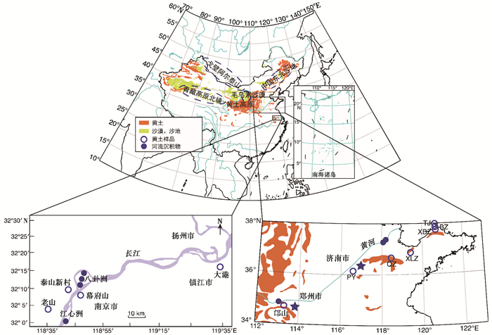
中国境内风尘堆积广泛分布(图 1),其中最为典型的是黄土高原风成黄土堆积。此外,中国西北部、东部、东北部、青藏高原及其周缘也有大量的风尘堆积序列[1~3]。风尘黄土堆积是古气候研究的重要材料[4~9];物源研究直接影响黄土沉积的古气候解读[10]。例如,风尘粒度是黄土研究最具代表性的古气候指标之一,并显示出与冰量的密切联系 ,可能反映了冬季风强度[7],或者反映了源区距离的远近,并与夏季风强度有关[12, 13],或者记录不同风力系统的相互竞争有关[14~16]。物源解析可以区分这些机制。

|
图 1 中国黄土与沙漠分布图和样品采集位置 Fig. 1 Map showing the distribution of loess and desert in China and locations of the sampling sites |
多年来,中国黄土物源研究主要围绕黄土高原黄土展开。根据沉积速度和粒度自西北向东南逐渐变低、变细的趋势以及现代冬春季节盛行的西北风,刘东生等[1]认为黄土高原黄土来自其西北部、北部和西部广袤的干旱区。自此,针对黄土高原黄土的物源,中外科学家开展了大量的地貌学、沉积学和地球化学研究[13, 17~21]。除准噶尔盆地以外,几乎所有中国内陆干旱区都曾被指认为黄土高原黄土的风尘源区,包括黄土高原北部的毛乌素沙地和库布齐沙地[12, 13, 22],黄河河谷及其关联的沙地[23~25],黄土高原以西的柴达木盆地[17, 26, 27]和塔里木盆地[18]。最近十年来,Nd、Sr同位素,锆石U-Pb年龄谱等系列地球化学化学证据把黄土高原黄土物源圈定于其西北上风向祁连山与戈壁之间的广袤地区[19, 20, 28~31]。
相对于黄土高原黄土,中国东部黄土物源研究程度低,众多问题尚有争议。中国东部黄土主要分布于黄河下游沿岸地区、山东半岛及其滨海地区、长江中下游地区[1]。中国东部风成黄土堆积始于第四纪晚期(约0.8Ma),与中更新世革命的时间吻合,具有一定古气候指示意义[32~35]。部分研究认为中国东部黄土与黄土高原黄土一样,来自中国内陆干旱区,中更新世革命之后,冬季风加强,亚洲内陆干旱程度加剧,促进了粉尘的释放,从而将亚洲内陆干旱区的粉尘搬运至更远的地区[1, 32, 36, 37]。也有研究认为,东部黄土大都位于大河的中下游,可能来自近源的河流沉积物,中更新世革命之后的冰期阶段,长江与黄河中下游地区干旱化加剧,植被减少,同时冬季风增强,出现区域性风尘活动,从而形成风成黄土堆积[34, 38~44]。因此,中国东部黄土物源研究有助于解析第四纪晚期以来的区域环境演化。
地球化学是黄土风尘物源示踪最主要的手段[10],并已建立大量方法,如Nd、Sr同位素[21, 30],碎屑锆石U-Pb年龄谱[24, 26, 45~47],白云石碳氧同位素组成、碎屑碳酸盐含量及其微量元素组成[48, 49],石英电子自旋共振信号和氧同位素组成等[28, 50]。这些地球化学指标能有效反映最终物质剥蚀区的岩石成分或年龄,是一种岩石学示踪。黄河和长江沉积物以及中国北方干旱区地表物质均主要接受来自青藏高原的物质,且经过大范围的混合,具有相似的地球化学特征[45, 51]。因此,现有地球化学方法不能有效区分中国东部黄土的潜在物源。
细颗粒物质的234U/238U比值反映颗粒自破碎以来经历的时间,与原始岩石成分无关,是一种地貌学物源示踪[52]。不同的物质来源伴随不同的破碎机制和搬运途径,对应不同的颗粒破碎时间,因此具有不同的234U/238U同位素比值。
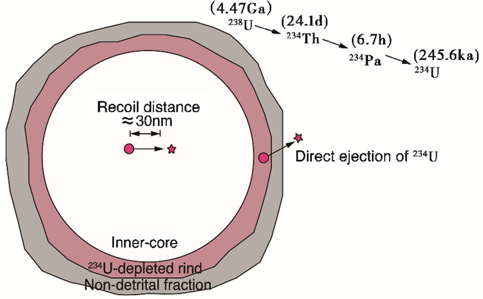
岩石中234U是238U系列衰变的产物(图 2)。238U核素经过α衰变变为234Th,半衰期长达4.47Ga。234Th经过两次快速的β衰变(半衰期分别为24.1天和6.7小时)变为234U。因此,岩石中234U核素的产率取决于238U的含量。234U核素并不稳定,经过α衰变成为230Th,半衰期为245.6ka[53]。经过多个234U-230Th半衰期以后,岩石中234U的产生速度等于234U的衰变速度,达到稳态平衡:

|
图 2 颗粒表面α衰变反冲作用示意图 改自Depaolo等[52] Fig. 2 Figure modified from Depaolo et al.[52]showing the recoil effect associated with the alpha decay of 238U at the surface of mineral grain |

|
(1) |
其中λ为衰变常数。因此,在平衡条件下,岩石的234U/238U同位素比值为234U和238U放射性衰变常数的反比:

|
(2) |
由于234U/238U绝对比值很小,234U/238U同位素比值一般表示为与平衡比值的比值(234U/238U),即放射性活度比:

|
(3) |
在平衡条件下,(234U/238U)值为1。
岩石破碎以后,部分238U核素α衰变产生234Th(234U的母体)被反冲作用推出颗粒表面(图 2),导致颗粒中234U的累积速度小于衰变速度。因此,颗粒的(234U/238U)值自破碎开始,会随时间t的增加而逐渐变小,直到新的平衡[54]:

|
(4) |
其中f(S)为被反冲作用推出颗粒表面的234Th的比例,与颗粒的比表面积S有关。颗粒越细,f值越大[54]。综上所述,由α衰变反冲作用导致的234U/238U比值变化与原始岩石的成分无关,记录了颗粒从破碎开始经历的时间,具有示踪物质地表过程的巨大潜力。
铀同位素可能为东部黄土的物源研究提供新的技术支持[55];细粒风尘物质主要以高空悬浮的形式搬运[56];现代沙尘暴观测显示细颗粒的搬运时间往往只需要数天甚至几个小时[57]。因此,风成黄土颗粒从物源区到堆积区的搬运过程中颗粒的破碎时间几乎不变,其(234U/238U)也不会发生变化。比较新鲜黄土即黄土沉积时的初始(234U/238U)值和潜在源区物质的(234U/238U)值可以示踪黄土的物源。
2 材料和方法本研究采集了中国东部地区末次盛冰期以来的黄土样品,采样地点包括山东半岛及其滨海地区、黄河沿岸和长江下游(图 1)。山东半岛黄土采自鲁中地区、山东半岛滨海地区和庙岛群岛[34, 58~61];黄河下游沿岸黄土采自黄河南岸的邙山地区和平阴地区[38, 62];长江下游的下蜀黄土样品采自江苏宁镇地区幕府山、泰山新村、大港和老山等4处[63]。潜在源区样品主要采集了黄河和长江下游的现代河流沉积物。样品清单与分析测试结果见表 1。
| 表 1 样品的采样位置和U同位素组成 Table 1 Locations of the samples and their U isotopic composition |
所有样品的前处理和同位素分析在南京大学表生地球化学教育部重点实验室完成[55]。首先将约10g样品用0.5mol/L醋酸自然浸泡2小时分散并去除碳酸盐。分散后的样品用电成型筛分离出20~25μm粒级。该粒级是黄土的主要粒度组分[13, 14],且容易人工分离。筛分出的样品先后用碳酸氢钠—二水合柠檬酸三钠—连二亚硫酸钠还原清洗方法去除铁锰氧化物和氢氧化物,双氧水浸泡去除有机质。清洗后的样品采用硅酸盐方法消解,并通过树脂分离出U[55, 64]。U同位素比值在Neptune Plus型(Thermo-Fisher Scientific)多接收等离子体质谱仪上测定,并采用SSB(Standard Sample Bracketing)方法校正仪器短期漂移。括标采用已标定的实验室内部标样NJU,其(234U/238U)值为0.950。(234U/238U)值测量误差为± 0.002(±2σ)。长期测量BCR-2标准物质的(234U/238U)值为1.001±0.002(n=21,2σ)[55],在误差范围内与国际认可比值一致。
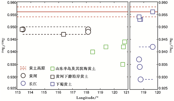
3 结果中国东部黄土的U同位素组成具有明显的区域特征。山东半岛及其滨海黄土的(234U/238U)值较低且变化较大,介于0.935~0.944之间;下蜀黄土的(234U/238U)值变化范围小,平均为0.954,与黄土高原黄土接近[55];黄河下游沿岸黄土的U同位素组成与黄河下游现代沉积物一致,低于黄土高原黄土[55];长江现代沉积物的(234U/238U)值较低,介于0.929~0.942之间(图 3)。

|
图 3 中国东部黄土和长江、黄河的(234U/238U)特征 黄土高原表层黄土的数据根据Li等[55] Fig. 3 The(234U/ 238U)ratios of the loess deposits in Eastern China and the sediments of the Changjiang River and Yellow River. The(234U/238U)ratio of the fresh loess deposits in the Chinese Loess Plateau is from Li et al.[55] |
末次冰期以来的黄土沉积时间短,其(234U/238U)值可以看作沉积时的初始(234U/238U)值。山东半岛及其滨海黄土(234U/238U)值明显低于黄土高原新鲜黄土的(234U/238U)值[55]。这些黄土不太可能直接搬运自西北干旱区。山东半岛及其滨海黄土的(234U/238U)值比现代黄河还低。因此推断,山东半岛及其滨海黄土与黄河下游平原或渤海湾大陆架沉积物有关。黄河下游平原和渤海湾陆架物质可能大部分由古黄河搬运堆积形成的。中更新世革命后,全球变冷,海平面下降[65~68],渤海黄海大面积陆架出露为陆地,先前沉积的地层风化解体,黄河下游平原冲积物也发生沙化,从而为山东半岛及滨海地区提供风尘物源[69]。由于沉积物在黄河下游平原和渤海湾存留较长时间,其(234U/238U)值随着沉积时间(破碎时间)的增加而降低,从而导致山东半岛及其滨海黄土的(234U/238U)值较低。
黄河下游南岸邙山与平阴地区位于黄土高原下风向,其物质可能直接通过冬季风经过黄土高原搬运至邙山地区。邙山黄土地层自倒数第二次间冰期(S2)以来沉积速率迅速增加,沉积厚度远大于黄土高原黄土[38]。一般认为,邙山黄土来自就近的黄河沉积物的快速堆积[38]。邙山黄土和平阴黄土的(234U/238U)值与黄河沉积物一致,位于0.947~0.949之间(表 1),而低于黄土高原新鲜黄土的(234U/238U)值(0.956)[55](图 3)。因此,黄河下游沿岸黄土可能主要来自黄河沉积物,与前人的推断一致。
下蜀黄土细粒物质的(234U/238U)值在误差范围内与黄土高原黄土难以区分(图 3)。基于粗粒碎屑锆石U-Pb年龄证据显示,下蜀黄土与黄土高原黄土及其北方潜在源区物质差别较大,但与长江沉积物具有极高的相似性[40]。粒度证据表明下蜀黄土的粗细物质应具有统一的物源[32]。因此,下蜀黄土可能主要来自近源的长江沉积物。但是,现代长江沉积物的(234U/238U)值在0.929~0.942之间,明显低于下蜀黄土沉积时的初始(234U/238U)值(表 1)。我们推测,由于现在水利工程的修建,如三峡工程,长江沉积物的物源和(234U/238U)值可能发生了巨大改变。现代长江沉积物可能具有更多的已沉积物质的再循环[70],导致长江下游现代沉积物具有低并且大变化范围的(234U/238U)值。这种低(234U/238U)值物质不太可能来自老的沉积物质,因为老的沉积岩由于破碎时间太长,其(234U/238U)值应该很低,已经达到平衡。下蜀黄土可能来自冰期阶段的长江物质,上游具有高(234U/238U)值物质的加入更多。在冰期阶段,长江下游冲积平原上或河谷的沉积物质暴露于地表,在沿岸形成风尘堆积。
5 结论细粒物质的(234U/238U)能示踪颗粒产生和搬运的一系列中间过程,可有效圈定中国东部各区域黄土的源区,弥补了传统地球化学示踪手段的不足。铀同位素和传统地球化学方法的结合将为亚洲风尘物源示踪提供新的思路。
铀同位素碎粒年龄学研究表明,中国东部黄土主要来自其附近的干旱区,具有近源性。黄河沿岸黄土的(234U/238U)值与黄河沉积物一致,位于0.947~0.949之间,低于黄土高原新鲜黄土的(234U/238U)值(0.956),因此,黄土下游沿岸黄土可能主要来自黄河沉积物;而山东半岛及其滨海黄土的(234U/238U)值低于现代黄河沉积物,推断其物质主要来自由古黄河搬运堆积在下游黄泛平原和渤海湾大陆架上的松散沉积物。在中更新世革命后,全球变冷,海平面下降,使得这些松散沉积物大量暴露在地表,为山东半岛及滨海地区的黄土堆积提供风尘物源。下蜀黄土的初始(234U/238U)值明显高于现代长江沉积物,因此我们推测可能来自冰期阶段长江沉积物。在冰期阶段,长江下游冲积平原上或河谷上原先沉积的物质暴露在地表,在沿岸形成风尘堆积。中国东部黄土的低(234U/238U)值表明源区物质在搬运形成黄土堆积之前经历长时间的沉积,而后可能由于中更新世革命后气候变冷,海平面下降,使得这些沉积物大面积暴露于地表,为黄土堆积提供大量的物质来源,同时也说明中更新世革命以来中国东部可能存在局部荒漠化。
致谢: 感谢审稿专家建设性的修改意见。谨以此文纪念刘东生院士诞辰100周年。本文受到国家自然科学基金项目(批准号:41422205和41730101) 资助。
| 1 |
刘东生, 等. 黄土与环境. 北京: 科学出版社, 1985, 1-321. Liu Tungsheng, et al. Loess and the Environment. Beijing: Science Press, 1985, 1-321. |
| 2 |
Sun J, Li S-H, Muhs D R, et al. Loess sedimentation in Tibet:Provenance, processes, and link with Quaternary glaciations. Quaternary Science Reviews, 2007, 26(17~18): 2265-2280. |
| 3 |
鹿化煜, 王先彦, 孙雪峰, 等. 钻探揭示的青藏高原东北部黄土地层与第四纪气候变化. 第四纪研究, 2007, 27(2): 230-241. Lu Huayu, Wang Xianyan, Sun Xuefeng, et al. Loess stratigraphy and palaeoclimate changes during Quaternary in northeastern Tibetan Plateau revealed by loess core. Quaternary Sciences, 2007, 27(2): 230-241. |
| 4 |
Chen F H, Bloemendal J, Wang J M, et al. High-resolution multi-proxy climate records from Chinese loess:Evidence for rapid climatic changes over the last 75 kyr. Palaeogeography, Palaeoclimatology, Palaeoecology, 1997, 130(1~4): 323-335. |
| 5 |
Guo Z, Ruddiman W F, Hao Q, et al. Onset of Asian desertification by 22 Myr ago inferred from loess deposits in China. Nature, 2002, 416(6877): 159-163. DOI:10.1038/416159a |
| 6 |
Zhou W, Xian F, Du Y, et al. The last 130 ka precipitation reconstruction from Chinese loess 10Be. Journal of Geophysical Research:Solid Earth, 2014, 119(1): 191-197. DOI:10.1002/2013JB010296 |
| 7 |
An Z, Kukla G J, Porter S C, et al. Magnetic susceptibility evidence of monsoon variation on the Loess Plateau of Central China during the last 130, 000 years. Quaternary Research, 1991, 36(1): 29-36. DOI:10.1016/0033-5894(91)90015-W |
| 8 |
Chen J, An Z, Head J. Variation of Rb/Sr ratios in the loess-paleosol sequences of Central China during the last 130, 000 years and their implications for monsoon paleoclimatology. Quaternary Research, 1999, 51(3): 215-219. DOI:10.1006/qres.1999.2038 |
| 9 |
Ding Z, Yu Z, Rutter N W, et al. Towards an orbital time scale for Chinese loess deposits. Quaternary Science Reviews, 1994, 13(1): 39-70. DOI:10.1016/0277-3791(94)90124-4 |
| 10 |
Chen Jun, Li Gaojun. Geochemical studies on the source region of Asian dust. Science China:Earth Sciences, 2011, 54(9): 1279-1301. DOI:10.1007/s11430-011-4269-z |
| 11 |
Hao Q, Wang L, Oldfield F, et al. Delayed build-up of Arctic ice sheets during 400, 000-year minima in insolation variability. Nature, 2012, 490(7420): 393-396. DOI:10.1038/nature11493 |
| 12 |
Ding Z L, Derbyshire E, Yang S L, et al. Stepwise expansion of desert environment across Northern China in the past 3.5Ma and implications for monsoon evolution. Earth and Planetary Science Letters, 2005, 237(1~2): 45-55. |
| 13 |
Yang S, Ding Z. Advance-retreat history of the East-Asian summer monsoon rainfall belt over Northern China during the last two glacial-interglacial cycles. Earth and Planetary Science Letters, 2008, 274(3-4): 499-510. DOI:10.1016/j.epsl.2008.08.001 |
| 14 |
Sun D, Bloemendal J, Rea D K, et al. Bimodal grain-size distribution of Chinese loess, and its palaeoclimatic implications. Catena, 2004, 55(3): 325-340. DOI:10.1016/S0341-8162(03)00109-7 |
| 15 |
Prins M A, Vriend M, Nugteren G, et al. Late Quaternary aeolian dust input variability on the Chinese Loess Plateau:Inferences from unmixing of loess grain-size records. Quaternary Science Reviews, 2007, 26(1): 230-242. |
| 16 |
Prins M A, Vriend M. Glacial and interglacial eolian dust dispersal patterns across the Chinese Loess Plateau inferred from decomposed loess grain-size records. Geochemistry, Geophysics, Geosystems, 2007, 8(7): 171-178. |
| 17 |
Bowler J M, Chen K Z, Yuan B Y. Systematic variations in loess source areas:Evidence from Qaidam and Qinghai bansins, Western China. In:Liu Tungshneg ed. Aspects of Loess Research. Beijing: China Ocean Press, 1987, 39-51.
|
| 18 |
Liu C-Q, Masuda A, Okada A, et al. Isotope geochemistry of Quaternary deposits from the arid lands in Northern China. Earth and Planetary Science Letters, 1994, 127(1~4): 25-38. |
| 19 |
Derbyshire E, Meng X, Kemp R A. Provenance, transport and characteristics of modern aeolian dust in western Gansu Province, China, and interpretation of the Quaternary loess record. Journal of Arid Environments, 1998, 39(3): 497-516. DOI:10.1006/jare.1997.0369 |
| 20 |
Ji J, Chen J, Lu H. Origin of illite in the loess from the Luochuan area, Loess Plateau, Central China. Clay Minerals, 1999, 34(4): 525-532. DOI:10.1180/000985599546398 |
| 21 |
Chen J, Li G, Yang J, et al. Nd and Sr isotopic characteristics of Chinese deserts:Implications for the provenances of Asian dust. Geochimica et Cosmochimica Acta, 2007, 71(15): 3904-3914. DOI:10.1016/j.gca.2007.04.033 |
| 22 |
Kapp P, Pullen A, Pelletier J D, et al. From dust to dust:Quaternary wind erosion of the Mu Us Desert and Loess Plateau, China. Geology, 2015, 43(9): 253-259. |
| 23 |
Bird A, Stevens T, Rittner M, et al. Quaternary dust source variation across the Chinese Loess Plateau. Palaeogeography, Palaeoclimatology, Palaeoecology, 2015, 435: 254-264. DOI:10.1016/j.palaeo.2015.06.024 |
| 24 |
Nie J, Stevens T, Rittner M, et al. Loess Plateau storage of northeastern Tibetan Plateau-derived Yellow River sediment. Nature Communications, 2015, 6(1): 8511. |
| 25 |
Stevens T, Carter A, Watson T P, et al. Genetic linkage between the Yellow River, the Mu Us Desert and the Chinese Loess Plateau. Quaternary Science Reviews, 2013, 78(19): 355-368. |
| 26 |
Pullen A, Kapp P, McCallister A T, et al. Qaidam Basin and northern Tibetan Plateau as dust sources for the Chinese Loess Plateau and paleoclimatic implications. Geology, 2011, 39(11): 1031-1034. DOI:10.1130/G32296.1 |
| 27 |
Kapp P, Pelletier J D, Rohrmann A, et al. Wind erosion in the Qaidam Basin, Central Asia:Implications for tectonics, paleoclimate, and the source of the Loess Plateau. GSA Today, 2011, 21(4): 4-10. DOI:10.1130/GSATG99A.1 |
| 28 |
Sun Y B, Tada R J, Chen J, et al. Tracing the provenance of fine-grained dust deposited on the central Chinese Loess Plateau. Geophysical Research Letters, 2008, 35(1): L01804. |
| 29 |
Sun Y B, Tada R J, Chen J, et al. Distinguishing the sources of Asian dust based on electron spin resonance signal intensity and crystallinity of quartz. Atmospheric Environment, 2007, 41(38): 8537-8548. DOI:10.1016/j.atmosenv.2007.07.014 |
| 30 |
Li G, Chen J, Ji J, et al. Natural and anthropogenic sources of East Asian dust. Geology, 2009, 37(8): 727-730. DOI:10.1130/G30031A.1 |
| 31 |
Sun J M. Provenance of loess material and formation of loess deposits on the Chinese Loess Plateau. Earth and Planetary Science Letters, 2002, 203(3-4): 845-859. DOI:10.1016/S0012-821X(02)00921-4 |
| 32 |
李徐生, 鹿化煜. 镇江下蜀黄土粒度特征及其成因初探. 海洋地质与第四纪地质, 2001, 21(1): 25-32. Li Xusheng, Lu Huayu. Grain-size features and genesis of the Xiashu loess in Zhenjiang. Marine Geolgy & Quaternarye Gology, 2001, 21(1): 25-32. |
| 33 |
李徐生, 杨达源. 镇江下蜀黄土-古土壤序列磁化率特征与环境记录. 中国沙漠, 2002, 22(1): 27-32. Li Xusheng, Yang Dayuan. Magnetic susceptibility features and environmental records of the Xiashu loess in Zhenjiang, Jiangsu Province. Journal of Desert Research, 2002, 22(1): 27-32. |
| 34 |
Peng S Z, Zhu L J, Xiao G Q, et al. Magnetostratigraphy and provenance of the Qingzhou loess in Shandong Province. Journal of Arid Land, 2011, 3(3): 184-190. DOI:10.3724/SP.J.1227.2011.00184 |
| 35 |
Qiao Y, Guo Z, Hao Q, et al. Loess-soil sequences in southern Anhui Province:Magneto stratigraphy and paleoclimatic significance. Chinese Science Bulletin, 2003, 48(19): 2088-2093. DOI:10.1360/03wd0183 |
| 36 |
杨守业, 李从先, 李徐生, 等. 长江下游下蜀黄土化学风化的地球化学研究. 地球化学, 2001, 30(4): 402-406. Yang Shouye, Li Congxian, Li Xusheng, et al. Geochemical records of chemical weathering of the Xiashu loess in the lower reaches of the Changjiang River. Geochimica, 2001, 30(4): 402-406. |
| 37 |
Xiong S, Sun D, Ding Z. Aeolian origin of the red earth in Southeast China.. Journal of Quaternary Sciences, 2002, 17(2): 181-191. DOI:10.1002/(ISSN)1099-1417 |
| 38 |
Zheng H, Huang X, Ji J, et al. Ultra-high rates of loess sedimentation at Zhengzhou since Stage 7:Implication for the Yellow River erosion of the Sanmen Gorge. Geomorphology, 2007, 85(3~4): 131-142. |
| 39 |
Hao Q, Guo Z, Qiao Y, et al. Geochemical evidence for the provenance of Middle Pleistocene loess deposits in Southern China. Quaternary Science Reviews, 2010, 29(23~24): 3317-3326. |
| 40 |
Liu Fei, Li Gaojun, Chen Jun. U-Pb ages of zircon grains reveal a proximal dust source of the Xiashu loess, lower Yangtze River region, China. Chinese Science Bulletin, 2014, 59(20): 2391-2395. DOI:10.1007/s11434-014-0318-2 |
| 41 |
徐树建. 山东庙岛群岛黄土的粒度特征及其环境意义. 海洋科学, 2008, 32(12): 60-63. Xu Shujian. Grain size characteristics and its indications of loess in Miaodao Islands, Shandong Province. Marine Sciences, 2008, 32(12): 60-63. |
| 42 |
Peng S, Hao Q, Wang L, et al. Geochemical and grain-size evidence for the provenance of loess deposits in the Central Shandong Mountains region, Northern China. Quaternary Research, 2016, 85(2): 290-298. DOI:10.1016/j.yqres.2016.01.005 |
| 43 |
刘乐军, 李培英, 王永吉. 鲁中黄土粒度特征及其成因探讨. 海洋地质与第四纪地质, 2000, 20(1): 81-86. Liu Lejun, Li Peiying, Wang Yongji. The grain-size properties and genesis of the loess in central Shandong Province. Marine Geology & Quaternary Geology, 2000, 20(1): 81-86. |
| 44 |
李楠, 郝青振, 张绪教, 等. 东秦岭黄土物源的常量元素和微量元素地球化学证据. 第四纪研究, 2016, 36(2): 332-346. Li Nan, Hao Qingzhen, Zhang Xujiao, et al. Geochemicl evidence for the provenance of loess deposits in the eastern Qinling Mountains, Central China. Quaternary Sciences, 2016, 36(2): 332-346. |
| 45 |
Che X, Li G. Binary sources of loess on the Chinese Loess Plateau revealed by U-Pb ages of zircon. Quaternary Research, 2013, 80(3): 545-551. DOI:10.1016/j.yqres.2013.05.007 |
| 46 |
Stevens T, Palk C, Carter A, et al. Assessing the provenance of loess and desert sediments in Northern China using U-Pb dating and morphology of detrital zircons. Geological Society of America Bulletin, 2010, 122(7~8): 1331-1344. |
| 47 |
Xiao G, Zong K, Li G, et al. Spatial and glacial-interglacial variations in provenance of the Chinese Loess Plateau. Geophysical Research Letters, 2012, 39(20): 2071-2075. |
| 48 |
Li G, Chen J, Chen Y, et al. Dolomite as a tracer for the source regions of Asian dust. Journal of Geophysical Research, 2007, 112(D17): 107-114. |
| 49 |
Li G, Chen J and Chen Y. Primary and secondary carbonate in Chinese loess discriminated by trace element composition. Geochimica et Cosmochimica Acta, 2013, 103(2): 26-35. |
| 50 |
Sun Y, Chen H, Tada R, et al. ESR signal intensity and crystallinity of quartz from Gobi and sandy deserts in East Asia and implication for tracing Asian dust provenance. Geochemistry, Geophysics, Geosystems, 2013, 14(8): 2615-2627. DOI:10.1002/ggge.20162 |
| 51 |
Stevens T, Adamiec G, Bird A F, et al. An abrupt shift in dust source on the Chinese Loess Plateau revealed through high sampling resolution OSL dating. Quaternary Science Reviews, 2013, 82: 121-132. DOI:10.1016/j.quascirev.2013.10.014 |
| 52 |
DePaolo D J, Maher K, Christensen J N, et al. Sediment transport time measured with U-series isotopes:Results from ODP North Atlantic drift site 984. Earth and Planetary Science Letters, 2006, 248(1~2): 394-410. |
| 53 |
Cheng H, Edwards Lawrence R, Shen C-C, et al. Improvements in 230Th dating, 230Th and234U half-life values, and U-Th isotopic measurements by multi-collector inductively coupled plasma mass spectrometry. Earth and Planetary Science Letters, 2013, 371~372: 82-91. |
| 54 |
DePaolo D J, Lee V E, Christensen J N, et al. Uranium comminution ages:Sediment transport and deposition time scales. Comptes Rendus Géoscience, 2012, 344(11~12): 678-687. |
| 55 |
Li L, Liu X, Li T, et al. Uranium comminution age tested by the eolian deposits on the Chinese Loess Plateau. Earth and Planetary Science Letters, 2017, 467: 64-71. DOI:10.1016/j.epsl.2017.03.014 |
| 56 |
Pye K. The nature, origin and accumulation of loess. Quaternary Science Reviews, 1995, 14(7): 653-667. |
| 57 |
Uno I, Eguchi K, Yumimoto K, et al. Asian dust transported one full circuit around the globe. Nature Geoscience, 2009, 2(8): 557-560. DOI:10.1038/ngeo583 |
| 58 |
郑洪汉, 朱照宇, 黄宝林, 等. 山东半岛及苏皖北部黄土地层年代学研究. 海洋地质与第四纪地质, 1994, 14(1): 63-68. Zheng Honghan, Zhu Zhaoyu, Huang Baolin, et al. A study on loess geochronoIogy of Shandong Peninsula and northern part of Jiangsu and Anhui provinces. Marine Geology & Quaternary Geology, 1994, 14(1): 63-68. |
| 59 |
徐树建, 王涛. 蓬莱黄土剖面光释光年代学及其沉积特征研究. 中国沙漠, 2011, 31(2): 295-301. Xu Shujian, Wang Tao. Optically stimulated luminescence dating and sedimentary characteristics of loess section at Penglai in Shandong Province. Journal of Desert Research, 2011, 31(2): 295-301. |
| 60 |
贾广菊, 徐树建, 孔凡彪, 等. 山东大黑山岛北庄黄土沉积特征及其环境演变. 第四纪研究, 2017, 37(3): 522-534. Jia Guangju, Xu Shujian, Kong Fanbiao, et al. The sedimentary characterisitics and environmental evolution of the Beizhuang loess in the Daheishan Island, Shandong Province. Quanternary Sciences, 2017, 37(3): 522-534. |
| 61 |
倪志超. 山东庙岛群岛黄土光释光年代及物源探讨. 济南: 山东师范大学硕士论文, 2015, 1-58. Ni Zhichao. Opticaly Stimulated Luminescence Dating and the Provenance Analysis of Loess in Miaodao Islands, Shandong Province. Jinan: The Master's Thesis of Shandong Normal University, 2015, 1-58. |
| 62 |
付信花. 山东平阴黄土剖面地球化学特征及其物质来源研究. 济南: 山东师范大学硕士论文, 2014, 1-52. Fu Xinhua. Geochemical Characteristics of Pingyin Loess and Its Provenance in Shandong Province. Jinan: The Master's Thesis of Shandong Normal University, 2014, 1-52. |
| 63 |
刘飞. 宁镇地区下蜀黄土物源的同位素地球化学示踪研究. 南京: 南京大学硕士论文, 2015, 1-73. Liu Fei. Trace the Source of Xiashu Loess in Ningzhen Region Using Isotope Geochemical Tools. Nanjing: The Master's Thesis of Nanjing University, 2015, 1-73. |
| 64 |
Zhang W, Chen J, Ji J, et al. Evolving flux of Asian dust in the North Pacific Ocean since the Late Oligocene. Aeolian Research, 2016, 23(12): 11-20. |
| 65 |
黄姜侬, 方家骅, 邵家骥, 等. 南京下蜀黄土沉积时代的研究. 地质海洋, 1988, 34(3): 240-247. Huang Jiangnong, Fang Jiaye, Shao Jiaji, et al. Study on the chronology of Xiashu loess in Nanjing area. Geological Review, 1988, 34(3): 240-247. |
| 66 |
Wang P X. Response of Western Pacific marginal seas to glacial cycles:Paleoceanographic and sedimentological features. Marine Geology, 1999, 156(1~4): 5-39. |
| 67 |
黄恩清. 中更新世以来东亚冬季风海陆记录对比. 第四纪研究, 2015, 35(6): 1331-1341. Huang Enqing. A comparison of the East Asian winter monsoon reconstructions from terrestrial and marine sedimentary records since the mid-Pleistocene. Quaternary Sciences, 2015, 35(6): 1331-1341. |
| 68 |
汪品先, 李前裕, 田军, 等. 从南海看第四纪大洋碳储库的长周期循环. 第四纪研究, 2015, 35(6): 1297-1319. Wang Pinxian, Li Qianyu, Tian Jun, et al. Long-term cycles in carbon reservoir of the Quaternary ocean:A perspective from the South China Sea. Quaternary Sciences, 2015, 35(6): 1297-1319. |
| 69 |
Xu S, Ding X, Yu L, et al. Palaeoclimatic implications of aeolian sediments on the Miaodao Islands, Bohai Sea, East China, based on OSL dating and proxies. Aeolian Research, 2015, 19(5): 259-266. |
| 70 |
Chen Z, Wang Z, Finlayson B, et al. Implications of flow control by the Three Gorges Dam on sediment and channel dynamics of the middle Yangtze(Changjiang)River, China. Geology, 2010, 38(11): 1043-1046. DOI:10.1130/G31271.1 |
② Shandong Provincial Key Laboratory of Water and Soil Conservation and Environmental Protection, Linyi University, College of Resources and Enviroment, Institute of Water and Soil Conservation and Environmental Protection, Linyi 276005;
③ Laboratory of Earth Surface Process and Environment, School of Geographic and Oceanographic Science, Nanjing University, Nanjing 210023)
Abstract
The 234U/238U ratio of fine particles can record the time since the particle breaking, which has great potential in tracing the surface processes. This work applies uranium isotope comminution age to constrain the source of the loess deposits in Eastern China. Here we collected the loess samples since the Last Glacial Maximum in Eastern China, including the Shandong Peninsula and its adjacent coastal area, the lower reaches of the Yellow River and the Changjiang River. The loess deposits in Shandong Peninsula were collected from the center of the Peninsula(QZ and XLZ profiles), its coastal area(XBZ profile), and the adjacent Miaodao Islands(BZ and TJ profiles). The loess deposits in the lower reaches of the Yellow River were collected from Mangshan region, Henan Province, and Pingyin region, Shandong Province. The Xiashu loess deposits in the lower reaches of the Changjiang River were collected from four sites, Mufushan, Taishanxincun, Dagang and Laoshan, in Ningzhen region. The sediment of Yellow River and Changjiang River were also collected to compare with the loess deposits. The(234U/238U)ratio of the loess deposits in Eastern China shows obvious regional characteristics. The loess deposits in the Shandong Peninsula and its adjacent coastal area show low and variable(234U/238U)values ranging from 0.935 and 0.944. The(234U/238U)value of Xiashu loess is relatively homogenous with a mean value of 0.954, which is similar to that of the fresh loess deposits on the Chinese Loess Plateau(CLP). The loess in the lower reaches of the Yellow River show(234U/238U)values consistent with the sediments in the floodplain of the Yellow River, which are lower than that of the loess deposits on the CLP. The modern sediments of the Changjiang River show low(234U/238U)values ranging from 0.929 to 0.942. The low initial 234U/238U ratio of the loess deposits in Eastern China indicates a dust source that is different to that of the loess on the CLP. Instead, the provenance of loess in Eastern China shows strong regional variation which is linked to the arid lands nearby. The Yellow River sediment exposed on the floodplain and the shelf during glacial times were the major source for the loess in Shandong Peninsula and its adjacent coastal area. The loess in the lower reaches of the Yellow River were blown directly from the floodplain of the Yellow River. Xiashu loess may be originated from the sediments of Changjiang River that were exposed during glacial times. 2017, Vol.37
