② 奥克兰大学, 环境学院, 新西兰, 奥克兰 1142)
大潮平均高潮线与低潮线之间的潮间滩涂是淤泥质海岸地貌系统的重要组成部分[1]。研究表明,潮间滩涂表层或湖泊沉积粒度能够灵敏地反映海岸或湖泊水动力条件,潮间带潮流以及湖泊水文状况的细微变化都会在表层沉积粒度构成上留下印迹[2~9]。另一方面,泥沙粒径的变化也会反映沉积动力条件的变化[10~14]。由于潮滩沉积可灵敏反应海岸带对全球变化和人类活动的响应,近年来潮滩的沉积机制、地貌演变及其蕴含的环境变化和人类活动信息得到研究和重视[1, 15~25]。
黄河口及三角洲以多泥沙少径流而闻名于世,沿其潮间带发育有典型淤泥质潮滩。与世界上其他大河一样,20世纪50年代以来黄河口入海泥沙显著减少[26~28]。关于黄河口泥沙减少的海岸地貌响应,前人已就三角洲海岸沉积动力过程[22, 23, 29~34]、海岸地貌冲淤及海岸线迁移[35~39]和北部废弃三角洲海岸蚀退[40]等做了深入研究。本文以南部废弃三角洲为对象,分析潮滩表层沉积粒度特征,探讨最近40多年来潮滩表层沉积粒度变化趋势,揭示黄河入海泥沙减少与废弃三角洲潮滩表层沉积粒度演变之间关系机理,加深对全球变化背景下淤泥质海岸地貌系统演变的认识。
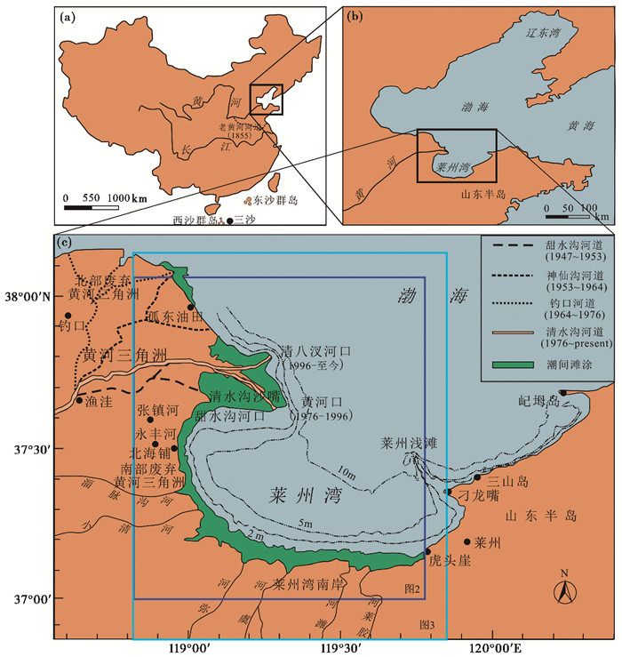
1 潮间滩涂地貌与沉积环境现代黄河口和黄河三角洲始于1855年黄河自苏北改道北流入渤海湾,此后黄河口沿渤海湾西岸南北频繁迁徙,每次都会迅速形成新河口及亚三角洲,废弃河口及亚三角洲则强烈蚀退[41]。在此过程中,这些亚三角洲构成的黄河三角洲整体不断向渤海湾深处延伸,三角洲南侧海域则被分隔为莱州湾1),其西南沿岸发育宽平的潮间滩涂,向东至虎头崖转为砂砾质海岸。其中,南部废弃三角洲位于莱州湾南岸平原和现行亚三角洲(清水沟沙嘴)之间,系1934~1938年、1947~1953年黄河口位于甜水沟口时形成的亚三角洲,废弃已逾60年(图 1)。
1)本文所指莱州湾系狭义的莱州湾,仅指黄河三角洲与莱州刁龙嘴连线以南部分,不包括刁龙嘴至屺坶岛沿岸海域
|
图 1 南部废弃黄河三角洲及其附近岸段地理位置 深蓝色框表示图 2中所示提取岸线和等深线的范围,淡蓝色框表示图 3中采样区域范围 Fig. 1 Location of the southern abandoned Yellow River sub-delta and its adjacent zones In the figure, the dark blue rectangle represents the range where the coastlines and isobaths are extracted as shown in fig. 2, and the light blue rectangle represents the scope of sampling as shown in fig. 3 |

|
图 2 南部废弃三角洲及附近岸段海岸地形演变 (a)显示岸线位置变化,(b)显示0、5m、10m等深线位置变化该图系用1958年、1976年、1984年、2002年和2009年测量水深数据叠加而成 Fig. 2 Coastal topography evolution of the southern abandoned Yellow River sub-delta and its adjacent zones during the last 60 years The figure is drawn based on nautical charts measured in 1958, 1976, 1984, 2002and 2009. Fig. 2a shows changes of the coastline, and Fig. 2b shows the changes of the 0m, 5m and 10m isobaths |
|
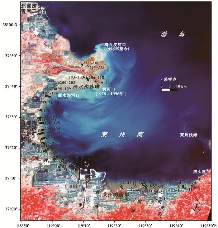
图 3 南部废弃三角洲及其附近岸段潮滩表层沉积样品采样位置 该图系用2014年5月1日卫星遥感影像为底图,样点按顺时针、自陆向海依次编号 Fig. 3 Sampling location of inter-tidal flat surficial sediment samples along the southern abandoned Yellow River sub-delta and its adjacent zones The figure is drawn based on the satellite remote sensing image on 1 May 2014 in which the sample points are arranged clockwise one after another from land to sea |
南部废弃三角洲濒临莱州湾西南部。按5m等深线计,莱州湾口西侧清水沟沙嘴长30km,东侧莱州浅滩及后方刁龙嘴长22km,湾口宽度(52km)仅及长度(100km)一半,绝大部分水深不到10m。据三山岛站资料,强浪和常浪NNE、频率12 %、波高平均1.3m、最大3.9m,次强浪NW向、频率6 %、波高平均1.1m、最大3.8m;而湾内-10m水深处常浪NE、频率25.27 %,强浪和次常浪NNE、频率17.35 %、大部分波高0.6m以下、极少数超过2.4m(频率0.41 %)[42]。受湾口轮廓限制,小清河口以东莱州湾南岸为NNE、NE波浪入湾后的直射岸段,废弃三角洲和现行亚三角洲(清水沟沙嘴)南侧属波浪衍射岸段。
莱州湾为不规则半日潮,平均潮差0. 61~1. 68m,自北向南增加,潮流属平行海岸往复流,涨潮流S、SW方向,落潮流N、NE方向[42]。受清水沟沙嘴东南突出的挑流作用影响,嘴外近岸有弧形高流速带,再外有潮流剪切锋带,均大致呈NE向展布。高流速带在沙嘴顶外流速最高达1. 8m/s,向西南递减,到小清河口东北仅0. 30~0. 40m/s[43, 44]。潮流剪切锋为近岸与岸外涨落潮流不同步而在其间形成的低流速带,西南端位于小清河口东北,带内垂线含沙大于15kg/m3,向两侧剧降到0. 5kg/m3[29, 30, 44~46]。废弃三角洲无河流入海,莱州湾南岸有小清河、弥河、白浪河、潍河、胶莱河等小河,但年输沙总量(263×104吨)不及黄河0. 3 %,且1980年前即已近断流[47]。
清水沟沙嘴自1976年形成后不断向东南延伸,岸线、0m等深线均向海大幅迁移,潮滩显著展宽且整体向海大幅迁移,直至1996年黄河口改至北侧清八汊河口后转为局部侵蚀,但总体保持稳定(图 2)。由于其对面的莱州浅滩不断向西北延伸[48],从1976年至1996年莱州湾渐趋封闭;与此同时,莱州湾不断变浅。1992年10m等深线向西南凹入海湾中部,但2006年已大幅向东北迁移[49]。目前,除湾口海拔超过10m外,大部分浅于10m。另一方面,1960年代以来南部废弃三角洲岸线、0m等深线位置基本稳定,即潮滩宽度无显著变化;莱州湾南部岸线向海小幅迁移、0m等深线基本稳定,即潮滩宽度有所减小,但潮滩外边界基本稳定(图 2)。
2 样品采集与测试2013年3月至2014年7月,选择落潮时采集了238个潮滩表层沉积样品,采样岸段为清水沟沙嘴北侧现行黄河口至虎头崖,包括南部废弃三角洲、现行亚三角洲和莱州湾南岸3个岸段(图 3)。第1~72号位于小清河口以东的莱州湾南岸,第73~194号位于南部废弃三角洲沿岸,第195~238号位于现行亚三角洲沿岸。238个样品中有106个样点自陆向海沿10个潮滩横断面布设,其中8个断面位于南部废弃三角洲,2个断面位于莱州湾南岸。由于研究区潮滩淤积速度快,为反映潮滩沉积作用现状并便于比较,统一采集潮滩表层0.5cm沉积样品。采样时使用自制的15cm×15cm×0.5cm采样器,单样重约200g。
样品带回实验室后用Malvern Mastersizer 2000激光粒度分析仪进行粒度测试分析。第一步,取0.2~0.4g的沉积物样品直接放至100ml烧杯中,加入10ml双氧水加热以去除样品有机质,至变清且没有细小泡沫时为止;第二步,加入10ml浓度10 %的盐酸并煮沸以去除碳酸盐;第三步,给烧杯注满蒸馏水,静置12小时后去除清液以去掉样品中絮凝性较强的Ca2+、H+等离子;第四步,加入10ml浓度的10 %分散剂(六偏磷酸钠溶液),用超声波清洗器震荡10分钟。最后,将经前处理的样品用激光粒度仪进行测量。
根据粒度测试结果,分别计算各样品的粘土、粉砂、砂、泥(粘土+粉砂)含量和粘土/泥比值,绘制各样品的粒度频率累积曲线;然后,提取各样品粒度曲线上累积含量5 %、16 %、25 %、50 %、75 %、84 %和90 %对应的粒径;再次,用Folk和Ward[14]公式计算各个样品的平均粒径(Mz)、分选系数(So)、偏态(Sk)和峰度(Kg),绘制各粒级构成比例和粒度参数沿海岸(纵向)和垂直海岸(横向)变化曲线;最后,按Flemming[50]提出的无砾沉积物粒度三角图编制方法,用砂、泥含量和粘土/泥比数据编制潮滩表层沉积粒度三角图。
以上各粒度参数中,平均粒径反映潮滩平均动能强弱,两者呈正相关;分选系数反映潮滩动能的波动性,两者呈负相关;偏态反映平均粒径相对于中值粒径的位置,正偏标志着细颗粒富集;反之,则反[51]。峰度对潮滩的沉积动力环境不敏感[52],它反映潮滩物源多样性程度,较大峰度意味着包含有来自附近环境但未经改造的碎屑组分。根据Collins[53]和Mazzulluo等[54]研究,潮滩沉积中泥含量越多则动力越强。根据Ergin和Bodur[55]研究,潮滩沉积中粉砂、粘土的相对含量(粘/泥比)越高则动力越弱。
为分析最近40年来潮滩表层沉积粒度演变趋势,搜集了前人发表的南部废弃三角洲及邻近岸段39个样品的砂、粉砂、粘土构成数据,包括1989年北海铺潮滩2个[56]、2006年淄脉沟河口至黄河口岸段潮滩17个[57]、2007年淄脉沟河口至老河口岸段潮滩20个[58, 59],分别计算其泥含量和粘/泥比。最后,用所得到的全部样品粒度数据连同本文所得数据绘制粒度三角图。
3 研究结果 3.1 粒度构成 3.1.1 砂、粉砂和粘土含量238个样品的砂、粉砂和粘土含量范围及平均值分别为0~90 % (40.78 %)、8 % ~94 % (55.11 %)和0~12 % (4.12 %),均不含砾石组分。除个别样品外,绝大部分潮滩样品的粘土含量低于10 %。其中,南部废弃三角洲潮滩样品的砂、粉砂、粘土含量范围及均值分别为1.92 % ~83.92 % (35.61 %)、14.03 % ~89.73 % (60.46 %)和0~9.91 % (3.93 %);现行黄河亚三角洲潮滩分别为1.14 % ~30.22 % (10.56 %)、7.92 % ~94.21 % (82.08 %)和11.91 % ~4.62 % (7.36 %);而莱州湾南岸潮滩分别为29.29 % ~90.95 % (68.00 %)、7.92 % ~65.51 % (29.55 %)和0~5.87 % (2.45 %)。
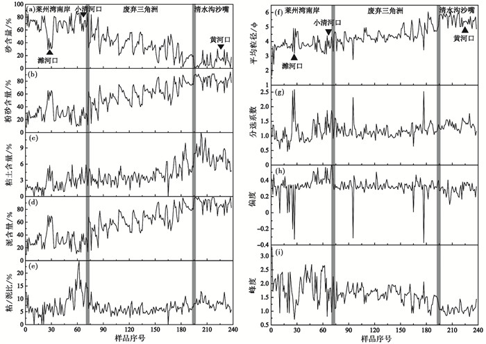
在各粒度构成比例曲线上,均存在3个高度不同但顶部大致平坦的“台阶”,南部废弃三角洲为居中的第二台阶(图 4a~4e)。这表明南部废弃三角洲与现行亚三角洲、莱州湾南岸潮滩样品的砂、粉砂、粘土及泥含量显著不同,其间呈不连续的突变关系。考虑到同地点多样品沿横剖面的变化,与南部废弃三角洲对应的“平台”是很平坦的,各比值沿岸变化不显著。总体上,除潍河口潟湖少数样品(25~31号)外,现行亚三角洲段潮间滩涂粒度构成以低砂-高粉-高粘为特征,莱州湾南岸为高砂-低粉-低粘,南部废弃三角洲介乎其间。
|
图 4 南部废弃三角洲及附近潮滩表层沉积物粒度构成与参数沿岸变化曲线 (a)砂含量(sand content);(b)粉砂含量(silt content);(c)粘土含量(clay content);(d)泥含量(mud content);(e)粘/泥比(clay/mud ratio);(f)平均粒径(mean grain size);(g)分选系数(sorting coefficient);(h)偏度(skewness);(i)峰度(kurtosis) Fig. 4 Grain size composition and granularity parameters of inter-tidal flat surficial sediment from the southern abandoned Yellow River sub-delta and its adjacent zones |
238个样品的泥含量和粘土/泥比的范围分别为9 % ~99 %和0~25 %,但南部废弃三角洲潮滩与现行亚三角洲、莱州湾南岸显著不同(图 4d和4e)。其中,现行亚三角洲的泥含量最高,莱州湾南岸的泥含量最低,南部废弃三角洲则介乎其间。现行亚三角洲潮滩的粘土/泥比最高,莱州湾南岸潮滩的粘土/泥比最低但波动很大,南部废弃三角洲介乎其间且波动很小。这种差异表明,南部废弃三角洲潮滩动力较现行亚三角洲为强,莱州湾南岸潮滩又较南部废弃三角洲和现行亚三角洲均强,但是其沿岸强弱波动很大。
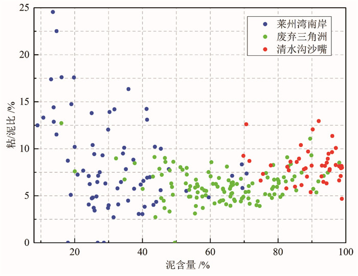
在泥含量-粘/泥比关系图中,南部废弃三角洲潮滩的大部分样点聚集于泥含量40 % ~90 %与粘/泥比3 % ~9 %区域,现行亚三角洲潮滩大部分样点聚集于泥含量70 % ~100 %与粘/泥比5 % ~12 %区域,莱州湾南岸大部分样点则聚集于泥含量10 % ~50 %与粘/泥比3 % ~17 %区域(图 5)。从总体上看,3个岸段潮滩样品的泥含量与粘土/泥比之间没有显著的相关关系,这暗示着控制南部废弃三角洲与现行亚三角洲潮间滩涂表层沉积中粉砂和粘土含量的沉积动力过程可能不一致。
|
图 5 南部废弃三角洲及附近海岸潮滩表层沉积样品的泥含量和粘/泥比关系 Fig. 5 The bivariate plot between the mud content and clay/mud ratio of inter-tidal flat surficial sediment along the southern abandoned Yellow River sub-delta and its adjacent zones |
在238个样品中,平均粒径3~4ϕ(极细砂)者69个、4~6ϕ(粉砂)者164个,分选较差和中等者分别为181个和49个,极正偏和正偏者分别为168个和62个,峰度很窄和窄者分别为123个和66个。粒度参数沿岸变化缺少连续性,平均粒径和峰度呈与粒度构成类似的“三台阶”状,废弃三角洲为居中的第二台阶,与其他两岸段呈突变式转换(图 4f~4i)。比较而言,现行亚三角洲粒度最细、峰度最小,莱州湾南岸粒度最粗、分选最好、偏度变幅最大、峰度最大,废弃三角洲则介乎其间且沿岸变化不显著。这表明,废弃三角洲潮滩平均粒径、分选系数、偏度和峰度及变化趋势,与现行亚三角洲差别明显。
废弃三角洲、现行亚三角洲和莱州湾南岸潮滩样品平均粒径范围及均值分别为2.76~6.04(4.44)ϕ、4.87~6.05(5.51)ϕ和1.69~4.90(3.74)ϕ。废弃三角洲122个样品中,平均粒径 < 3ϕ(细砂)1个( < 1 %)、3~4ϕ(极细砂)14个(11 %)、4~6ϕ(粉砂)106个(87 %)、>6ϕ(粘土)1个( <1 %);现行亚三角洲44个样品中,平均粒径4~6(粉砂)43个(98 %)、>6ϕ(粘土)1个(2 %);莱州湾南岸72个样品中,平均粒径 < 3(中、细砂)2个(3 %)、3~4ϕ(极细砂)54个(75 %)、4~6ϕ(粉砂)15个(21 %)、>6ϕ(粘土)1个(约1 %)(表 1)。因此,废弃三角洲潮滩较现行亚三角洲粗,莱州湾南岸又较废弃三角洲粗。这表明,莱州湾南岸潮滩平均动能最强,现行亚三角洲最弱,而南部废弃三角洲则介乎其间。
| 表 1 南部废弃三角洲及附近海岸潮滩表层沉积样品平均粒径统计表 Table 1 Mean grain size along the southern abandoned Yellow River sub-delta and its adjacent zones |
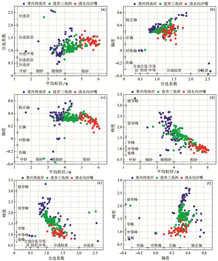
在平均粒径-分选系数关系图中,废弃三角洲潮滩大部分样点聚集在平均粒径4.0~5.5与分选系数0.8~1.5区域,现行亚三角洲大部分聚集在平均粒径5.0~6.0与分选系数1.1~1.6区域,而莱州湾南岸大部分散布在平均粒径3.0~5.0与分选系数0.75~1.90区域(图 6a)。比较而言,废弃三角洲潮滩表层沉积较现行亚三角洲粗,分选程度较现行亚三角洲好。总体上,废弃三角洲和莱州湾南岸潮滩的分选系数随平均粒径增加而增大,即颗粒越细则分选越差,颗粒越粗则分选越好,而现行亚三角洲不存在这种关系。这说明,与现行亚三角洲潮滩表层沉积主要系黄河泥沙进入潮间带海洋环境后,因动力、水文条件突变而就地堆积而成不同,废弃三角洲潮滩表层沉积物在堆积前曾经过海洋动力过程的长时间分选。
|
图 6 南部废弃三角洲及附近海岸潮滩表层沉积样品不同粒度参数之间的关系 Fig. 6 Bivariate plots between the different grain size parameters of inter-tidal flat surficial sediment of the southern abandoned Yellow River sub-delta and its adjacent zones |
在偏度-分选系数关系图中,废弃三角洲潮滩大部分样品位于偏度0.2~0.5与分选系数0.8~1.5区域,现行亚三角洲大部分位于偏度0.15~0.40与分选1.1~1.6区域,而莱州湾南岸大部分位于偏度0.2~0.6与分选0.75~1.90区域(图 6b)。除个别样品外,3个岸段大部分样品均属正偏,且废弃三角洲大部分样品偏度值较现行亚三角洲大(图 4h)。总体上,废弃三角洲及莱州湾南岸潮滩的偏度随分选系数增大而增大,即潮滩表层沉积中的细颗粒富集程度越高,则分选程度越差,而现行亚三角洲不存在这种关系。这显示,废弃三角洲潮滩沉积动力条件与现行亚三角洲存在显著差异。
在偏度-平均粒径关系图中,废弃三角洲潮滩大部分样品位于偏度0.2~0.5与平均粒径4.0~5.5区域,现行亚三角洲大部分位于偏度0.15~0.40与平均粒径5.0~6.0区域,而莱州湾南岸大部分位于偏度0.2~0.6与平均粒径5.0~6.0区域(图 6c)。其中,现行亚三角洲潮滩偏度与平均粒径负相关,即平均粒径越粗则细颗粒富集程度越大;废弃三角洲不存在此种关系,即细颗粒富集程度与平均粒径粗细不相关;莱州湾南岸则存在不显著的正相关。这表明,与现行亚三角洲不同,废弃三角洲潮滩表层沉积中占少量的细颗粒组分和占主体的粗颗粒组分可能是不同动力沉积过程的产物。
在峰度-平均粒径关系图中,废弃三角洲潮滩大部分样点聚集在峰度1.0~2.0与平均粒径4.0~5.5区域,现行亚三角洲大部分在峰度0.8~1.4与平均粒径5.0~6.0区域,而莱州湾南岸大部分在峰度0.5~2.7与平均粒径5.0~6.0区域(图 6d)。3个岸段潮滩的峰度均较大,暗示均包含未经海洋动力长距离改造、从附近环境直接进入潮间带堆积的碎屑,即沉积物源具有多样性,其中现行亚三角洲多样性程度最低、莱州湾南岸最高,废弃三角洲则介乎其间。三岸段大部分样点聚集区呈右下倾条带,即峰度随平均粒径变粗而升高,暗示样品越粗则其碎屑来源越复杂,废弃三角洲潮滩颗粒来源又较现行亚三角洲复杂。
在分选系数-峰度关系图中,废弃三角洲潮滩大部分样点聚集在分选系数0.8~1.5与峰度1.0~2.0区域,现行亚三角洲大部分在分选系数1.1~1.6与峰度0.8~1.4区域,莱州湾南岸大部分在分选系数0.75~1.90与峰度0.5~2.7区域(图 6e)。总体上,3个岸段的大部分样点聚集区均呈右下倾条带,峰度随分选系数增加而降低,即分选较好的样品具有较大的碎屑颗粒来源多样性。综合图 6d和图 6e,越是平均粒径粗、分选好的样品,其碎屑颗粒来源的多样性程度越高。因此,与现行亚三角洲不同,废弃三角洲潮滩碎屑来源具有较高的多样性。考虑到废弃三角洲没有河流入海,其沉积物源多样性暗示着其与潮上带、潮下带等存在活跃的沉积动力联系和泥沙交换。
在偏度-峰度关系图中,南部废弃三角洲潮滩大部分样点位于偏度0.2~0.5与峰度1.0~2.0区域,现行亚三角洲大部分位于偏度0.15~0.40与峰度0.8~1.4区域,莱州湾南岸大部分位于偏度0.2~0.6与峰度0.5~2.7区域(图 6f)。现行亚三角洲和莱州湾南岸潮滩大部分样品的偏度和峰度之间呈较明显的正相关关系,而位于二者中间的废弃三角洲不存在这种关系。这表明,与现行亚三角洲不同,废弃三角洲潮滩表层沉积中的碎屑颗粒来源多样性与细颗粒富集受控于不同的沉积动力过程。
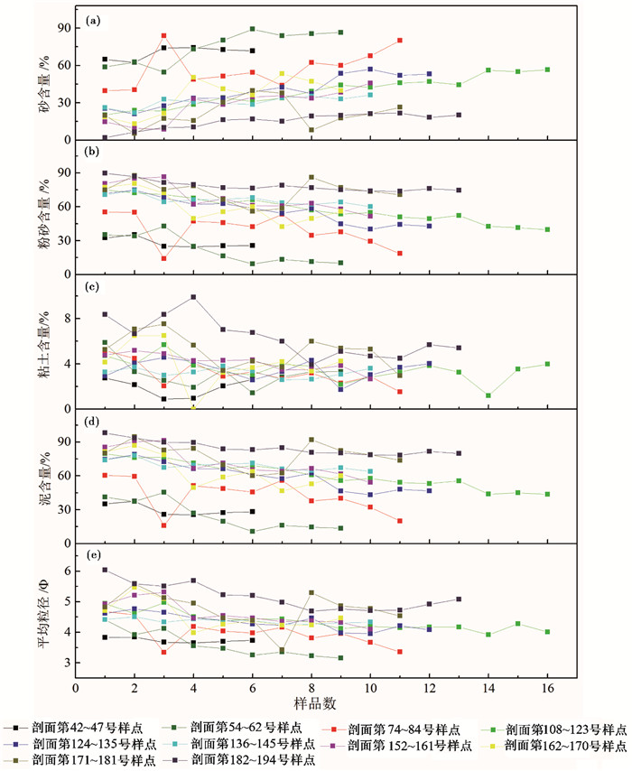
3.3 潮间滩涂横剖面粒度分布潮间滩涂与潮下带水下岸坡存在密切的动力地貌联系,是海岸地貌系统的重要组成部分。在10个潮间滩涂横剖面中,除2个位于莱州湾南岸外,其余8个均位于南部废弃三角洲海岸。这些剖面之间的粒度构成差别显著,自莱州湾南岸向废弃三角洲方向,潮滩沉积样品中的砂含量减低,粉砂和粘土及泥含量升高(图 7)。但是,10个横断面的粒度构成比例曲线均显示,沿自陆向海方向,即自潮间滩涂上部向下部,潮滩表层沉积显著变粗,砂含量显著增高,粉砂、粘土及泥含量显著降低,平均粒径显著变小(图 7)。
|
图 7 南部废弃三角洲潮滩表层沉积物粒度构成和平均粒径横向变化 (a)砂含量(sand content);(b)粉砂含量(silt content);(c)粘土含量(clay content);(d)泥含量(mud content);(e)平均粒径(mean grain size) Fig. 7 The profile change curves of grain size composition and mean grain size of inter-tidal flat surficial sediment from the southern abandoned sub-delta and its adjacent zones |
与潮间滩涂表层沉积从陆向海变粗相反,南部废弃三角洲及莱州湾西南部2m等深线以下水下岸坡的表层沉积自海向陆变粗。根据2007年的207个样品粒度资料,在南部废弃三角洲以东5m等深线以深海底,砂含量不到10 %、粉砂超过70 %、粘土超过20 %,但自此向2m等深线以浅,砂含量剧增,粉砂和粘土则剧减[60]。因此,在潮间带外缘即0m等深线与2m等深线间为平行岸线分布的狭窄粗颗粒沉积带,以高砂低泥为特征,自该带向陆、向海表层沉积均显著变细。如前述,南部废弃三角洲沿岸没有河流注入,而潮滩边界、位置和宽度自其废弃以来处于基本稳定状态。考虑到废弃三角洲潮滩粒度特征沿岸变化小、与邻近两个岸段呈突变关系,这暗示着其与现行亚三角洲及莱州湾南岸潮滩泥沙交换很少,但与水下岸坡存在较强的横向输沙交换,且总体上处于收支平衡状态。
4 讨论 4.1 潮间滩涂粗化潮滩粗化主要表现为粘土含量减少和粘/泥比降低。根据前人粒度资料,在淄脉沟河口至黄河口沿岸潮间滩涂,1983年3月和6月张镇河、永丰河等地高潮滩表层沉积为粘土含量20 % ~40 %的粘土质粉砂,低潮滩为粘土含量15 % ~20 %的粉砂[61];根据1989年北海铺两个潮滩表层样品粒度资料,高潮滩粘土含量39.8 %、中潮滩16.5 % [56];2006年17个样品粒度资料显示,淄脉沟河口至黄河口潮滩表层沉积的粘土含量5.72 % ~29.49 %、平均含量13.96 % [57]。以上这些说明,废弃三角洲潮滩表层沉积的粘土含量在1980s年代变化不显著,推测其在1990s年代开始减少,到2006年已显著变低。
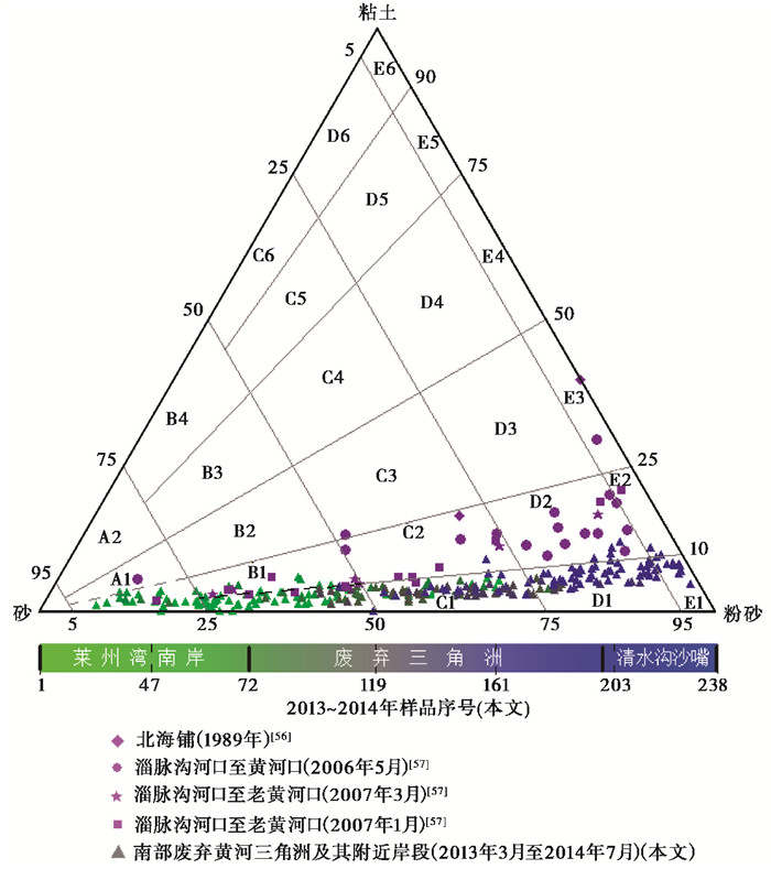
在粒度三角图上,2013~2014年的238个潮滩表层样品涵盖了从砂到泥的8个动力沉积类型,按照样品数量多少依次为C1(74个)、B1(67个)、D1(56个)、A1(22个)、E1(12个)、D2(4个)、E2(2个)、C2(1个)。从分布看,238个样点分布呈窄直的条带并偏于粉砂端,沿该条带自砂端向粉砂端,样点的粘/泥比的取值范围显著变小(图 8)。总体上,大部分样点的粘/泥比都在10 %以下,随着泥含量增加粘/泥比取值范围显著变小,当泥含量小于25 %时粘/泥比为0~25 %,泥含量为25 % ~50 %时粘/泥比为0~20 %,泥含量为50 % ~75 %时粘/泥比为2.5 % ~10.0 %,泥含量为75 % ~100 %时粘/泥比为5 % ~10 %。
|
图 8 南部废弃三角洲及其附近岸段潮滩砂/粉砂/粘土含量三角图 Fig. 8 Ternary diagrams based on sand/silt/clay ratios illustrating textural trends observed in the inter-tidal flats of the southern abandoned Yellow River sub-delta and its adjacent zones |
2006~2007年的潮滩表层沉积样点在粒度三角图上的分布也呈指向粉砂-粘土轴的平直长条带(图 8),横跨了从砂到粘土的若干沉积类型,但其条带位置显然要比2013~2014年条带更偏离粉砂端、接近粘土端,大部分样点的粘/泥比在10 %以上,且向粉砂-粘土轴其取值范围几乎没有变化,也不存在明显变窄趋势。其中,淄脉沟河口至黄河口2006~2007年17个潮滩样品的粘/泥比取值范围11.51 % ~32.99 %、平均值19.02 % [57]。因此,南部废弃三角洲潮滩在2007~2013年又发生了进一步的粗化。
2006年淄脉沟河口至黄河口潮滩17个样品的平均粘土含量14.14 %,除了2个样品在10 %以下而超过5 % (5.72 %和9.78 %)以外,其余均大于10 % (10.59 % ~29.49 %)[57];而在同一岸段,本研究的2014年152个样品(第72~223号,分布在南部废弃三角洲和清水沟沙嘴南侧潮滩)中只有3个大于10 % (最大值为11.91 %),其余样品均小于10 % (平均4.96 %)。根据研究,当粘土含量减少到5 % ~10 %临界值时,沉积物会发生从粘性砂到非粘性砂的转变,这是因为当粘土含量低于该临界值时沉积物抗侵蚀强度降低,而侵蚀又会导致沉积物分选程度提高[62, 63]。因此,表层沉积中粘土含量的微小变化对潮滩冲淤和分选有重要影响。也就是说,在20世纪90年代开始的粗化基础上,在2007年到2013年之间南部废弃三角洲潮滩表层又发生了从粘性砂到非粘性砂的转变。
4.2 粗化原因分析潮滩粗化原因包括水动力增强和沉积物源变化。根据Pejrup[64]的水动力模型,粒度三角图中样点位置反映其沉积时的水动力条件,潮滩粗化代表水动力增强。但是,由于现行亚三角洲清水沟沙嘴从1976年起不断向东南方海中延伸,直至1996年河口改道至清水沟沙嘴北侧后转为总体稳定(图 2)。再考虑到对岸莱州浅滩同步向西北方海中延伸,必然导致莱州湾湾口渐趋封闭、进潮量减少,即从1976年至1996年莱州湾总趋势是动力变弱、1996年后总体稳定,这已被水动力数值模拟[44]结果所支持。因此,潮滩粗化的主要原因不可能是水动力变强。另一方面,作为著名的多泥沙河口,在黄河中上游大中型水库修建前的1919年到1960年,黄河口平均每年有多达12×108吨悬沙入海[65]。此后,受到中上游水库拦截及气候变化影响,在1960s、1970s、1980s、1990s和2000s年代的年均入海泥沙量分别是10.89×10⁸吨、8.98×10⁸吨、6.37×10⁸吨、4.029×10⁸吨和1.34×10⁸吨,2010~2014年的年平均值只有1.2914×10⁸吨,呈明显减少趋势。同样的原因,莱州湾南部的小清河、潍河、胶莱河等小河的入海输沙,在数十年前的20世纪80年代以前就几近消失[47]。因此,南部废弃三角洲潮滩粗化主要原因是黄河泥沙减少。
从图 6可以看出,根据分选系数与平均粒径、偏度的关系,废弃三角洲潮滩具有不同于现行亚三角洲的动力、沉积条件(图 6a和6b);根据峰度与平均粒径、分选系数的关系,废弃三角洲潮滩表层碎屑颗粒来源具有较高的多样性(图 6d和6e);而根据偏度与峰度、平均粒径的关系,废弃三角洲潮滩表层碎屑颗粒来源的多样性与其细颗粒富集受控于不同的沉积动力,少量的粘土等细颗粒和占主体的砂质粗颗粒组分不是同一潮滩动力沉积过程的产物(图 6c和6f)。这是因为,废弃三角洲潮滩沉积原为废弃前黄河入海泥沙在河口附近潮间带直接堆积而成的粘性砂,河口废弃及此后的黄河入海泥沙减少使废弃三角洲以东的莱州湾西南部水下岸坡泥沙补给减少,导致从水下岸坡进入潮间带的涨潮流携带的泥沙减少,当其经过上述0~2m等深线之间粗颗粒带时,将该带部分粉砂颗粒带入潮间带,而落潮流又将原潮滩沉积中的部分粘土颗粒带走,结果是潮滩中粘土减少、粘土/泥比降低,最终转为非粘性砂。
黄河入海输沙减少导致的潮滩粗化并非孤立现象。在废弃三角洲濒临的莱州湾西南部海域北部水深2~10m海底,1980年代前就发现有所谓的“烂泥湾”,系黄河泥沙入海后快速堆积而成的粉砂质粘土区,其表层为粘土含量高、易被波浪扰动再悬浮的浮泥[43, 66, 67]。但是,到1999年时与“烂泥湾”对应的粉砂质粘土区较1985年已大大缩小[68]。该海域中部水深5~10m海底,1980s年代表层沉积中值粒径9~7(局部9以上)、仅边缘区5~6[42],而2007年平均粒径只有6.0~6.5,虽局部在6.5以上,但最大值也仅7.1[60],即使考虑到中值粒径与平均粒径的差异,仍能显示出显著变粗趋势。该海域南部水深0~5m海底,从1980年到1997年沉积物也明显粗化[69]。这是因为,黄河入海泥沙减少后,能够悬浮进入水深较大海底的粘土颗粒减少,原有浮泥中粘土颗粒在波浪扰动、潮流搬运作用下扩散殆尽。
在更长时间尺度上,据历史文献记载和地质记录,伴随着黄河口频繁迁徙导致的黄河入海泥沙减少/消失,黄河三角洲所在岸段曾有过沙质-淤泥质、海侵-海退的多次交替,时间尺度有数百年和千年不等[22, 23, 70~74];在较短时间尺度上,大量研究显示,最近数十年来黄河三角洲北部各亚三角洲在河口迁移、失去泥沙补给后均发生迅速蚀退[40, 41]。对废弃更早的南部废弃三角洲而言,潮间滩涂表层沉积动力地貌属性发生这种转变后,未来泥沙继续减少及全球变化背景下的地貌响应,值得深入研究并及早应对。
5 结论南部废弃黄河三角洲潮间滩涂表层沉积粒度构成与现行黄河亚三角洲、莱州湾南岸均有显著不同,不同岸段粒度构成存在显著的空间不连续性(图 4a~4e)。具体而言,南部废弃三角洲的砂、粉砂、粘土与其他岸段的含量显著不同,其间呈不连续的突变关系。总体上,现行亚三角洲潮间滩涂粒度构成特征为低砂、高粉、高粘,莱州湾南岸表现为高砂、低粉、低粘,南部废弃三角洲介乎其间(图 4a~4c)。南部废弃三角洲潮滩的泥含量和粘土/泥比与现行亚三角洲、莱州湾南岸显著不同。现行亚三角洲的泥含量和粘土/泥比最高,莱州湾南岸的泥含量最低,南部废弃三角洲则介乎其间(图 4d~4e)。3个岸段潮滩样品的泥含量与粘土/泥比之间没有显著的相关关系(图 5)。
南部废弃三角洲潮间滩涂表层沉积的平均粒径、分选系数、偏度和峰度及其变化趋势与现行亚三角洲、莱州湾南岸差别显著(图 4f~4i)。现行亚三角洲粒度最细、峰度最小,莱州湾南岸粒度最粗、分选最好、偏度变幅最大、峰度最大,废弃三角洲则介乎其间但内部沿岸纵向变化不显著(图 4f~4i)。从平均粒径范围及均值可知,莱州湾南岸潮滩最粗,而废弃三角洲潮滩较现行亚三角洲又粗(表 1)。从不同粒度参数之间的关系来看,废弃三角洲潮滩表层沉积的平均粒径与分选系数、分选系数与峰度、分选系数与偏度之间关系,与莱州湾南岸相同,而与现行亚三角洲不同(图 6a、6b和6e)。具体而言,废弃三角洲和莱州湾南岸潮滩的分选系数随平均粒径增加而增大(图 6a);偏度随分选系数增大而增大(图 6b);潮滩碎屑来源具有较高的多样性(图 6e),而现行亚三角洲不存在这种关系或现象。平均粒径与偏度、偏度与峰度之间关系,与其他岸段均不同(图 6c和6f)。现行亚三角洲潮滩偏度与平均粒径负相关;废弃三角洲不存在此种关系;莱州湾南岸则存在不显著的正相关(图 6c)。现行亚三角洲和莱州湾南岸潮滩大部分样品的偏度和峰度之间呈较明显的正相关,而位于二者中间的废弃三角洲不存在这种关系(图 6f)。平均粒径与峰度之间的关系与两岸段均相同(图 6d)。3个岸段潮滩的峰度均较大,其中现行亚三角洲多样性程度最低、莱州湾南岸最高,废弃三角洲则介乎其间(图 6d)。
在横向上,不同剖面之间的粒度构成差别显著,自莱州湾南岸向废弃三角洲方向,潮滩沉积样品中的砂含量降低,粉砂和粘土及泥含量升高(图 7)。沿自陆向海方向的砂含量显著增高,粉砂、粘土及泥含量显著降低,平均粒径显著变小(图 7)。与潮间滩涂表层沉积自陆向海变粗相反,南部废弃三角洲及莱州湾西南部2m等深线以下水下岸坡的表层沉积自海向陆变粗。总体上,南部废弃三角洲潮滩表层沉积自陆向海显著变粗,过渡为水下岸坡上部的潮下粗颗粒带,自此带向水下岸坡下部又转为变细。
南部废弃三角洲潮滩经历了河口行水期的沉积建造和废弃以来的动力改造,占少量的细粒组分主要沉积于河口行水时期的三角洲潮间滩涂,而占主体的粗粒组分系废弃后潮滩经现代沉积动力过程改造而成。由于黄河入海泥沙显著减少后进入潮下带海底的泥沙减少,潮滩与莱州湾西南部潮下带水下岸坡之间泥沙输运状态发生变化,潮滩原有细颗粒泥沙流失、潮下带部分粗颗粒泥沙进入潮滩,结果使得废弃三角洲潮滩表层沉积中的粘土含量减少、粘/泥比减小即潮滩粗化。潮滩粗化的时间开始于1990s年代,在2007~2013年间又进一步发生了从粘性砂向非粘性砂的转变。
致谢 乔学谨、赵倩、崔玉磊、苏明燕等参加野外潮滩采样,山东省水土保持重点实验室的徐树建教授在粒度测试时予以指导帮助,特向上述人员和杨美芳老师、匿名审稿人的帮助致以诚挚谢忱!
| 1 |
Eisma D. Intertidal Deposits: River Mouths, Tidal Flats and Coastal Lagoons. New York: CRC Press, 1998, 1-16. |
| 2 |
Johnson M A, Kenyon N H, Belderson R H et al. Sand transport. In: Stride A H ed. Offshore Tidal Sands. Springer, 1980. 58~94
|
| 3 |
Kenyon N H, Stride A H. The tide-swept continental shelf sediments between the Shetland Isles and France. Sedimentology, 1970, 14(3-4): 159-173. DOI:10.1111/sed.1970.14.issue-3-4 |
| 4 |
涂路遥, 周鑫, 刘毅等. 近海泥质沉积物敏感粒径作为冬季风强度指标的再研究:与器测数据的对比. 第四纪研究, 2015, 35(6): 1393-1401. Jiang Tao, Zeng Zhigang, Nan Qingyun et al. The grain size characteristics of the core S9 sediments in the northern Okinawa Trough and their paleoclimate response since Holocene. Quaternary Sciences, 2015, 35(2): 307-318. DOI:10.11928/j.issn.1001-7410.2015.02.06 |
| 5 |
姜韬, 曾志刚, 南青云等. 全新世以来冲绳海槽北部S9孔粒度变化特征及其古气候响应. 第四纪研究, 2015, 35(2): 307-318. Tu Luyao, Zhou Xin, Liu Yi et al. Re-analysis of sensitive grain size of coastal muddy sediments as proxy of winter monsoon strength: Comparison with instrumental data. Quaternary Sciences, 2015, 35(6): 1393-1401. |
| 6 |
范佳伟, 肖举乐, 温锐林等. 达里湖沉积粒度组分-湖面状况定量模型. 第四纪研究, 2016, 36(3): 612-622. Fan Jiawei, Xiao Jule, Wen Ruilin et al. A model for the linkage between grain-size component in the Dali Lake sediments and lake level status. Quaternary Sciences, 2016, 36(3): 612-622. |
| 7 |
李渊, 强明瑞, 王刚刚等. 晚冰期以来共和盆地更尕海碎屑物质输入过程与气候变化. 第四纪研究, 2015, 35(1): 160-171. Li Yuan, Qiang Mingrui, Wang Ganggang et al. Processes of exogenous detrital input to Genggahai Lake and climatic changes in the Gonghe basin since the Late Glacial. Quaternary Sciences, 2015, 35(1): 160-171. |
| 8 |
刘亚生, 常凤琴, 张虎才等. 云南腾冲青海湖泊沉积物物化参数的特点、环境意义及末次冰消期以来气候环境变化. 第四纪研究, 2015, 35(4): 922-933. Liu Yasheng, Chang Fengqin, Zhang Hucai et al. Environmental significance of physicochemical parameters of sediment and climate changes since the Late Glacial at Qinghai Lake of Tengchong County, Yunnan Province. Quaternary Sciences, 2015, 35(4): 922-933. |
| 9 |
郭超, 马玉贞, 刘杰瑞等. 过去2000年来西藏羊卓雍错沉积物粒度记录的气候变化. 第四纪研究, 2016, 36(2): 405-419. Guo Chao, Ma Yuzhen, Liu Jierui et al. Climatic change recorded by grain-size in the past about 2000 years from Yamzhog Yumco Lake, Tibet. Quaternary Sciences, 2016, 36(2): 405-419. |
| 10 |
Anthony E J, Héquette A. The grain size characterization of coastal sand from the Somme estuary to Belgium: Sediment sorting processes and mixing in a tide-and storm-dominated setting. Sedimentary Geology, 2007, 202(3): 369-382. DOI:10.1016/j.sedgeo.2007.03.022 |
| 11 |
Anthony E J, Gardel A, Gratiot N et al. The Amazon-influenced muddy coast of South America: A review of mud-bank-shoreline interactions. Earth-Science Reviews, 2010, 103(3-4): 99-121. DOI:10.1016/j.earscirev.2010.09.008 |
| 12 |
Bartholomä A, Flemming B W. Progressive grain size sorting along an intertidal energy gradient. Sedimentary Geology, 2007, 202(3): 464-472. DOI:10.1016/j.sedgeo.2007.03.010 |
| 13 |
Flemming B W. Process and pattern of sediment mixing in a microtidal coastal lagoon along the west coast of South Africa. Tidalites, 1988, 275-288. |
| 14 |
Folk R J, Ward W C. A study in a significance of grain size parameters. Journal of Sedimentary Research, 1957, 27(1): 3-26. DOI:10.1306/74D70646-2B21-11D7-8648000102C1865D |
| 15 |
Chang T S, Flemming B W, Bartholomä A. Distinction between sortable silts and aggregated particles in muddy intertidal sediments of the east Frisian Wadden Sea, southern North Sea. Sedimentary Geology, 2007, 202(3): 453-463. DOI:10.1016/j.sedgeo.2007.03.009 |
| 16 |
Clarke D W, Boyle J F, Chiverrell R C. A sediment record of barrier estuary behaviour at the mesoscale: Interpreting high-resolution particle size analysis. Geomorphology, 2014, 221: 51-68. DOI:10.1016/j.geomorph.2014.05.029 |
| 17 |
Gensac E, Gardel A, Lesourd S et al. Morphodynamic evolution of an intertidal mudflat under the influence of Amazon sediment supply-Kourou mud bank, French Guiana, South America, Estuarine. Coastal and Shelf Science, 2015, 158: 53-62. DOI:10.1016/j.ecss.2015.03.017 |
| 18 |
Jongepier I, Wang C, Missiaen T et al. Intertidal landscape response time to dike breaching and stepwise re-embankment: A combined historical and geomorphological study. Geomorphology, 2015, 236: 64-78. DOI:10.1016/j.geomorph.2015.02.012 |
| 19 |
Law B A, Milligan T G, Hill P S et al. Flocculation on a muddy intertidal flat in Willapa Bay, Washington, Part Ⅰ: A regional survey of the grain size of surficial sediments. Continental Shelf Research, 2013, 60: S136-S144. DOI:10.1016/j.csr.2012.06.007 |
| 20 |
Rahman R, Plater A J. Particle-size evidence of estuary evolution: A rapid and diagnostic tool for determining the nature of recent saltmarsh accretion. Geomorphology, 2014, 213: 139-152. DOI:10.1016/j.geomorph.2014.01.004 |
| 21 |
Zhou Z, Coco G, Wegen M et al. Modeling sorting dynamics of cohesive and non-cohesive sediments on intertidal flats under the effect of tides and wind waves. Continental Shelf Research, 2015, 104: 76-91. DOI:10.1016/j.csr.2015.05.010 |
| 22 |
胥勤勉, 胡云壮, 袁桂邦等. 渤海湾西南岸古黄河三角洲全新世地层层序和演化过程. 第四纪研究, 2015, 35(2): 326-339. Xu Qinmian, Hu Yunzhuang, Yuan Guibang et al. Holocene sequence stratigraphy and evolution of the ancient Yellow River delta in the southwestern coast of the Bohai Bay. Quaternary Sciences, 2015, 35(2): 326-339. DOI:10.11928/j.issn.1001-7410.2015.02.08 |
| 23 |
刘世昊, 丰爱平, 李培英等. 现代黄河三角洲地区晚更新世以来高分辨率沉积粒度特征及动力沉积环境演化. 第四纪研究, 2015, 35(2): 291-306. Liu Shihao, Feng Aiping, Li Peiying et al. High-resolution grain size distribution and evolution of the sediment-dynamic environment in the modern Yellow River delta since the Latest Pleistocene. Quaternary Sciences, 2015, 35(2): 291-306. DOI:10.11928/j.issn.1001-7410.2015.02.05 |
| 24 |
王颖, 邹欣庆, 殷勇等. 河海交互作用与黄东海域古扬子大三角洲体系研究. 第四纪研究, 2012, 32(6): 1055-1064. Wang Ying, Zou Xinqing, Yin Yong et al. Study on river-sea interaction and formation of paleo-Yangtze grand delta system in the area of south Yellow Sea and East China Sea. Quaternary Sciences, 2012, 32(6): 1055-1064. |
| 25 |
王颖, 傅光翮, 张永战. 河海交互作用沉积与平原地貌发育. 第四纪研究, 2007, 27(5): 674-689. Wang Ying, Fu Guanghe, Zhang Yongzhan. River-sea interactive sedimentation and plain morphological evolution. Quaternary Sciences, 2007, 27(5): 674-689. |
| 26 |
Wang H J, Yang Z S, Li Y H et al. Dispersal pattern of suspended sediment in the shear frontal zone off the Yellow(Yellow River)mouth. Continental Shelf Research, 2007, 27(6): 854-871. DOI:10.1016/j.csr.2006.12.002 |
| 27 |
Wang H J, Saito Y, Zhang Y et al. Recent changes of sediment flux to the western Pacific Ocean from major rivers in East and Southeast Asia. Earth-Science Reviews, 2011, 108(1-2): 80-100. DOI:10.1016/j.earscirev.2011.06.003 |
| 28 |
Yu Y G, Shi X F, Wang H J et al. Effects of dams on water and sediment delivery to the sea by the Huanghe(Yellow River): The special role of Water-Sediment Modulation. Anthropocene, 2013, 3: 72-82. DOI:10.1016/j.ancene.2014.03.001 |
| 29 |
Li G X, Wei H L, Han Y S et al. Sedimentation in the Yellow River delta, part Ⅰ: Flow and suspended sediment structure in the upper distributary and the estuary. Marine Geology, 1998, 149: 93-111. DOI:10.1016/S0025-3227(98)00031-0 |
| 30 |
Li G X, Wei H L, Yue S H et al. Sedimentation in the Yellow River delta, part Ⅱ: Suspended sediment dispersal and deposition on the subaqueous delta. Marine Geology, 1998, 149: 113-131. DOI:10.1016/S0025-3227(98)00032-2 |
| 31 |
Li G X, Zhuang K L, Wei H L. Sedimentation in the Yellow River delta. Part Ⅲ: Seabed erosion and diapirism in the abandoned subaqueous delta lobe, 2000, 168: 129-144. |
| 32 |
Qiao L L, Bao X W, Wu D X et al. Numerical study of generation of the tidal shear front of the Yellow River mouth. Continental Shelf Research, 2008, 28(14): 1782-1790. DOI:10.1016/j.csr.2008.04.007 |
| 33 |
Qiao S Q, Shi X F, Saito Y et al. Sedimentary records of natural and artificial Yellow(Yellow River)channel shifts during the Holocene in the southern Bohai Sea. Continental Shelf Research, 2011, 31: 1336-1342. DOI:10.1016/j.csr.2011.05.007 |
| 34 |
Yang Z S, Ji Y J, Bi N S et al. Sediment transport off the Huanghe(Yellow River)delta and in the adjacent Bohai Sea in winter and seasonal comparison. Estuarine, Coastal and Shelf Science, 2011, 93: 173-181. DOI:10.1016/j.ecss.2010.06.005 |
| 35 |
Chu Z X, Sun X G, Zhai S K et al. Changing pattern of accretion/erosion of the modern Yellow River(Huanghe) subaerial delta, China: Based on remote sensing images. Marine Geology, 2006, 227(1-2): 13-30. DOI:10.1016/j.margeo.2005.11.013 |
| 36 |
Ma Yanyan, Li Guangxue. Evolution history and trend of the modern Yellow River delta. Acta Oceanologica Sinica, 2010, 29(2): 40-52. DOI:10.1007/s13131-010-0020-4 |
| 37 |
Cui B L, Li X Y. Coastline change of the Yellow River estuary and its response to the sediment and runoff(1976-2005). Geomorphology, 2011, 127(1-2): 32-40. DOI:10.1016/j.geomorph.2010.12.001 |
| 38 |
Liu Y X, Huang H J, Qiu Z F et al. Detecting coastline change from satellite images based on beach slope estimation in a tidal flat. International Journal of Applied Earth Observation and Geoinformation, 2013, 23(1): 165-176. |
| 39 |
Bi N S, Wang H J, Yang Z S. Recent changes in the erosion-accretion patterns of the active Yellow(Yellow River)delta lobe caused by human activities. Continental Shelf Research, 2014, 90: 70-78. DOI:10.1016/j.csr.2014.02.014 |
| 40 |
Wang H J, Yang Z S, Li G X et al. Wave climate modeling on the abandoned Huanghe(Yellow River)delta lobe and related deltaic erosion. Journal of Coastal Research, 2006, 22(4): 906-918. |
| 41 |
郭永盛. 近代黄河三角洲海岸的变迁. 海洋科学, 1980, 4(1): 30-34. Guo Yongsheng. Coastal change of the modern Yellow River delta. Marine Sciences, 1980, 4(1): 30-34. |
| 42 |
中国海湾志编委会. 中国海湾志(第三分册). 北京: 海洋出版社, 1993. 1~81 Edition Committee of the Bay Chorography in China. The Bay Chorography in China(3). Beijing: China Ocean Press, 1993. 1~81 |
| 43 |
武桂秋. 现行黄河口烂泥形成的动力机制. 海岸工程, 1992, 11(2): 44-52. Wu Guiqiu. The study on dynamic mechanism for formation of muddy sediment at present Yellow River estuary. Coastal Engineering, 1992, 11(2): 44-52. |
| 44 |
李蒙蒙, 王庆, 张安定等. 最近50a来莱州湾西-南部潮流动力演变的数值模拟研究. 海洋学报, 2014, 36(5): 68-76. Li Mengmeng, Wang Qing, Zhang Anding et al. Study on the evolution of the tidal morphodynamic processes in south-western Laizhou Bay based on numerical simulation in the past 50 years. Acta Oceanologica Sinica, 2014, 36(5): 68-76. |
| 45 |
Li Guangxue, Cheng Guodong, Wei Helong et al. Shearing zone of the current field off the modern Yellow River mouth. Chinese Science Bulletin, 1994, 39(10): 928-932. |
| 46 |
高佳, 陈学恩, 于华明等. 黄河口海域潮汐、潮流、余流、剪切锋数值模拟. 中国海洋大学学报, 2010, 40(增刊): 41-48. Gao Jia, Chen Xue'en, Yu Huaming et al. Numerical simulation of tides, tidal currents, residual currents and shear front in estuary. Periodical of Ocean University of China, 2010, 40(Suppl): 41-48. |
| 47 |
阎新兴, 郑海霞. 山东潍坊北港近海区地貌特征及泥沙来源分析. 海洋通报, 1992, 11(4): 65-72. Yan Xinxing, Zheng Haixia. Analyses of geomorphology and sediment sources inshore of Weifang North Harbor, Shandong Province. Marine Science Bulletin, 1992, 11(4): 65-72. |
| 48 |
Wang Q, Zhang M M, Zhong S Y et al. Dynamic sedimentation and geomorphologic evolution of the Laizhou shoal, the Bohai Sea, Northern China. Journal of Asian Earth Sciences, 2009, 36(2-3): 196-208. DOI:10.1016/j.jseaes.2009.06.001 |
| 49 |
岳保静, 栾锡武, 张亮等. 近20年来渤海南部水深变化. 海洋地质与第四纪地质, 2010, 30(3): 15-21. Yue Baojing, Luan Xiwu, Zhang Liang et al. Water depth variation of southern Bohai Sea in recent 20 years. Marine Geology & Quaternary Geology, 2010, 30(3): 15-21. |
| 50 |
Flemming B W. A revised textural classification of gravel-free muddy sediments on the basis of ternary diagrams. Continental Shelf Research, 2000, 20(10-11): 1125-1137. DOI:10.1016/S0278-4343(00)00015-7 |
| 51 |
Sahu B K. Depositional mechanism from the size analysis of clastic sediments. Journal of Sediment Research, 1964, 34(1): 73-83. |
| 52 |
Friedman G M. Distinction between dune, beach and river sands from their textural characteristics. International Journal of Sediment Research, 1961, 31(4): 514-529. |
| 53 |
Collins M. Sediment transport in the Bristol channel: A review. Proceedings of the Geological Association, 1987, 98(4): 367-383. DOI:10.1016/S0016-7878(87)80076-7 |
| 54 |
Mazzullo J, Leschak P, Prusak D. Sources and distribution of Late Quaternary silt in the surficial sediment of the northeastern continental shelf of the United States. Marine Geology, 1988, 78(3-4): 241-254. DOI:10.1016/0025-3227(88)90112-0 |
| 55 |
Ergin M, Bodur M N. Silt/clay fractionation in surficial Marmara sediments: Implication for water movement and sediment transport paths in a semi-enclosed and two-layered flow system(northeastern Mediterranean Sea). Geo-Marine Letters, 1999, 18(3): 225-233. |
| 56 |
李元芳, 黄云麟, 李栓科. 近代黄河三角洲海岸潮滩地貌及其沉积的初步分析. 海洋学报, 1991, 13(5): 662-671. Li Yuanfang, Huang Yunlin, Li Shuanke. Preliminary analysis of coastal/tidal landform and its sedimentation along the present Yellow River delta. Acta Oceanologica Sinica, 1991, 13(5): 662-671. |
| 57 |
邢云. 基于磁性特征的长江口和黄河口表层沉积物比较研究. 上海: 华东师大硕士学位论文, 2007, 84-89. Xing Yun. Comparative Studies on the Magnetic Properties of Surface Sediments from the Changjiang Estuary and the Huanghe Estuary. Shanghai: Master's Dissertation of East China Normal University, 2007, 84-89. |
| 58 |
刘桂卫, 黄海军, 刘艳霞等. 风暴潮前后莱州湾西岸岸滩演化特征研究. 海洋科学集刊, 2010, 50: 32-39. Liu Guiwei, Huang Haijun, Liu Yanxia et al. Numerical study on characteristics of beach evolution during storm surge periods in west coast of Laizhou Bay. Studia Marina Sinica, 2010, 50: 32-39. |
| 59 |
陈斌, 黄海军. 莱州湾西南岸海域悬浮泥沙与沉积物粒度分布特征. 海洋通报, 2014, 33(4): 436-443. |
| 60 |
张盼, 吴建政, 胡日军等. 莱州湾西南部表层沉积物粒度分布特征及其现代沉积环境分区. 海洋地质前沿, 2014, 30(9): 11-17. Zhang Pan, Wu Jianzheng, Hu Rijun et al. Distribution of surface sediments and modern sedimentary environment in the southwestern Laizhou Bay. Marine Geology Frontiers, 2014, 30(9): 11-17. |
| 61 |
刘仲衡, 吴锦绣, 于永杰等. 利用粒度资料浅析黄河三角洲潮坪沉积环境. 山东海洋学院学报, 1985, 15(1): 159-167. Liu Zhongheng, Wu Jinxiu, Yu Yongjie et al. The utilization of grain size material in preliminary analysis of the tidal flat sedimentary environment of the Yellow River delta. Journal of Shandong College of Oceanology, 1985, 15(1): 159-167. |
| 62 |
Dyer K R. Coastal and Estuarine Sediment Dynamics. Chichester: John Wiley, 1986, 1-342. |
| 63 |
Van Ledden M, Van Kesteren W G M, Winterwerp J C. A conceptual framework for the erosion behavior of sand-mud mixtures. Continental Shelf Research, 2004, 24(1): 1-11. DOI:10.1016/j.csr.2003.09.002 |
| 64 |
Pejrup M. The Triangular Diagram Used for Classification of Estuarine Sediments: A New Approach. Denmark: Pergamon Press, 1988, 289-300. |
| 65 |
钱宁, 周文浩. 黄河下游河床演变. 北京: 科学出版社, 1965, 1-160. Qian Ning, Zhou Wenhao. Morphological Evolution Process in the Lower Yellow River. Beijing: Science Press, 1965, 1-160. |
| 66 |
庞家珍, 司书亨. 黄河口河口演变(Ⅱ)河口水文特征及泥沙淤积分布. 海洋与湖沼, 1980, 11(4): 296-305. Pang Jiazhen, Si Shuheng. Fluvial process of the Yellow River estuary Ⅱ. Hydrographical character and the region of sediment silting. Oceanologia et Limnologia Sinica, 1980, 11(4): 296-305. |
| 67 |
刘凤岳, 高明德. 黄河口烂泥湾的特征及其开发. 海洋科学, 1986, 10(1): 20-23. Liu Fengyue, Gao Mingde. The characteristics and exploitation of the mud bay at the Yellow River estuary. Marine Sciences, 1986, 10(1): 20-23. |
| 68 |
吕丹梅, 李元洁. 黄河口及渤海中南部沉积特征变化及其环境动力分析. 中国海洋大学学报, 2004, 34(1): 133-138. Lü Danmei, Li Yuanjie. Variability of sediment distribution and analysis of hydrodynamic environment in the Yellow estuary and the mid-south Bohai Sea. Journal of Ocean University of China, 2004, 34(1): 133-138. |
| 69 |
刘国亭, 阎新兴. 小清河河口地貌调查及沉积物分析. 水道港口, 1998(3): 33-36. Liu Guoting, Yan Xinxing. Geomorphic surveys and sediment analysis of Xiaoqinghe estuary. Journal of Waterway and Harbor, 1998(3): 33-36. |
| 70 |
陈吉余. 海岸地貌. 见: 中国自然地理编委会编. 中国自然地理(地貌). 北京: 科学出版社, 1980. 322~324 Chen Jiyu. Coastal landform. In: Chinese Editorial Committee of Physical Geography ed. Chinese Physical Geography(Landform). Beijing: Science Press, 1980. 322~324 |
| 71 |
陈吉余. 渤海湾海岸的历史变迁. 见: 中国自然地理编委会编. 中国自然地理(历史自然地理). 北京: 科学出版社, 1982. 230~232 Chen Jiyu. The historical changes of Bohai Gulf coast. In: Chinese Editorial Committee of Physical Geography ed. Chinese Physical Geography(Historical Physical Geography). Beijing: Science Press, 1982. 230~232 |
| 72 |
Saito Y, Wei H L, Zhou Y Q et al. Delta progradation and chenier formation in the Huanghe(Yellow River)delta, China. Journal of Asian Earth Sciences, 2000, 18(4): 489-497. DOI:10.1016/S1367-9120(99)00080-2 |
| 73 |
陈晓辉, 李日辉, 孙荣涛等. 末次冰消期以来辽东半岛东南近岸泥质区的古环境演化. 第四纪研究, 2016, 36(6): 1489-1501. Chen Xiaohui, Li Rihui, Sun Rongtao et al. Paleo-environmental evolution in the southeast coastal mud area off Liaodong Peninsula since the Last Deglaciation. Quaternary Sciences, 2016, 36(6): 1489-1501. |
| 74 |
李守军, 崔肖辉, 徐华等. 莱州湾晚第四纪介形虫分布特征与沉积环境演化. 第四纪研究, 2016, 36(6): 1475-1488. Li Shoujun, Cui Xiaohui, Xu Hua et al. Distribution characteristics of ostracods and evolution of the sedimentary environment of the Late Quaternary in the Laizhou Bay, Bohai Sea. Quaternary Sciences, 2016, 36(6): 1475-1488. |
② School of Environment, The University of Auckland, New Zealand, Auckland 1142)
Abstract
The modern Yellow River mouth and the Yellow River delta has developed since the Yellow River began to pour into the Bohai Sea again in 1855. Since then, the Yellow River estuary has migrated north-south frequently along the western coast of Bohai Bay. In landform evolution, a new river mouth sandspit and a sub-delta formed rapidly, and the abandoned sub-delta retreated synchronously in response to each estuary migration. As a result, the Yellow River delta, which constituted by many sub-deltas, has extended into the Bohai Sea continually in its evolution history. Thus the Laizhou Bay was cut out of the southern Bohai Bay as an independent bay. The southern abandoned Yellow River sub-delta(SAYS) mainly developed during the periods of 1934~1938 and 1947~1953 when the Yellow River flown into the Bohai Sea along the Tianshuigou channel which has abandoned for more than 60 years. The SAYS located between its two adjacent geomorphic units of the present Yellow River sub-delta(PYS)and the sedimentation plain along the southern Laizhou Bay(PSLB), whose inter-tidal zone has developed wide flat gravel-free muddy inter-tidal flats. A total of 238 surficial sediment samples along the inter-tidal flats(including whole SAYS and its adjacent zones)were collected during ebb tide in the period of March 2013 to July 2014. Furthermore, 106 sample points are arranged along 10 inter-tidal flat transverse profiles, of which 8 profiles are located in SAYS and the other 2 are located in PSLB. The surficial flat sediment samples were evaluated by grain size analysis and granularity parameter calculation. According to the granularity analysis results, the grain size frequency cumulative curves of each sample was drawn by the contents of grain size and clay, silt, sand and mud(clay plus silt), as well as the ratio of clay/mud. The grain size parameters of mean grain size(Mz), sorting coefficient(So), skewness(Sk)and kurtosis(Kg)were obtained via the Folk and Ward method. To analyze grain size evolution tendency of inter-tidal flat surficial sediment in the recent 40 years, all published data about the sand-silt-clay composition of the inter-tidal flat surficial sediment samples along SAYS and its adjacent regions were collected. The data of the inter-tidal flat along SAYS were later compared with those of its adjacent depositional units and those of SAYS published over the last 40 years. Finally, the grain size characteristics and tendency were discussed under the background of the sediment flux decrease from the Yellow River since the 1980s. The results indicate that the grain size characteristics and the relations between the different granularity parameters of inter-tidal surficial sediment along the SAYS are very different from those of the PYS. The clay and sand components come from the different dynamical depositional process, respectively. Among them, the clay component is mainly deposited in the inter-tidal flats along the Yellow River sub-delta and the sand component attributes to the effect of the modern deposition dynamical process on the abandoned inter-tidal flats. Under the background of the sharp decrease in sediment flux from the Yellow River estuary, inter-tidal flat has transverse sediment exchange with sub-tidal submarine slope of the south-western Laizhou Bay, implying the fine grain loss and the coarse grain enrichment of the tidal flat. As a result, the SAYS's surficial sediments have coarsened significantly, represented by the decrease in clay content and clay/mud ratio. The transition from cohesive to non-cohesive sediment was finished during the period from 2007 to 2013. Just because of the inter-tidal surficial sediment coarsening, the width and location of inter-tidal flat along the SAYS have remained stable on the whole since the abandonment of SAYS decades ago. However, the transition behaviour from cohesive to non-cohesive of the surficial sediment will necessarily have a profound impact on the future coastal geomorphic evolution. 2017, Vol.37
