② 中国科学院青藏高原研究所, 北京 100101;
③ 中国科学院大学, 北京 100049)
在全球气候变化的背景下,青藏高原的湖面变化及水文状态得到了广泛关注。作为水循环与水资源的重要组成部分,湖泊对气候变化的响应很敏感,从而使其成为气候变化的指示器。对湖泊古水位及古水文状态的研究,有利于我们更加深入地理解和探讨气候变化的历史和机制。
当前,湖泊古水位及古水文状态的重建方法主要有两大类。一类是地貌学的方法。已经有众多学者利用湖岸阶地及湖岸线高程和年代相结合的方法来重建古湖面高度[1~7]。这种方法可以获取特定时期的湖面高度,却无法获取连续的古水位及古水文状态演化信息。另一类是基于环境替代指标的重建。在前人研究工作中,湖面变化和古水文状态的恢复主要是利用湖芯环境代用指标而反演重建得出[8~18]。此外,湖芯的14C定年由于受碳库效应的影响,年代有着一定的不确定性[19],同时湖泊沉积物的环境代用指标的解释也有一定的多解性和复杂性[20, 21]。目前,湖泊古水位及古水文状态与气候变化之间的关联仍然存在较大的不确定性和不完整性。导致这种局面形成的一个主要原因,就是缺乏一种研究古水文、古水化学和古气候的理想载体。
湖岸线及高湖面沉积物是直接反映地质历史时期湖面状态和记录古环境信息的地貌和岩性证据。这些湖岸地貌及沉积物不仅反映了湖泊水体变化历史,同时也可作为揭示区域乃至全球环境变化的重要载体。高湖面沉积物是指当湖泊水位降低时,原先临近湖岸的湖泊沉积物由于湖泊面积缩小而露出地表的物质。在青藏高原,经常可见湖泊环湖分布着多级由湖相砂与粘土沉积所组成的湖岸堆积阶地[22]。其中,湖相沉积多为富含碳酸盐的灰白色粉砂、细沙或粘土。我们前期的野外调查发现,萝卜螺壳体化石(图 1a)广泛地存在于这些高湖面沉积物中(例如,纳木错、沉错、羊卓雍错、许如错和当惹雍错等)[23]。萝卜螺属(Radix)属于肺螺亚纲的椎实螺科(Pulmonata;Lymnaeidae)。由于其“体型巨大”,一个萝卜螺壳体的平均氧同位素代表大约一年的信息,能够记录年内甚至半个月内湖泊的水文、水化学和气候变化信息[24~26]。

|
图 1 纳木错耳萝卜螺壳体照片 (a)化石耳萝卜螺壳体(Fossil shell of Radix auricularia;(b)现生耳萝卜螺壳体(Living shell of Radix auricularia) Fig. 1 The photos of the Radix auricularia collected from the Lake Nam Co |
本文以纳木错高湖面沉积物为研究对象,尝试利用高湖面沉积中的萝卜螺壳体化石,定量重建纳木错高湖面时期(约4.4~2.2ka)湖水的古水化学特征;进而利用萝卜螺壳体δ18Oshell与湖泊水文状态的关系,并结合湖盆地貌和古湖岸线地貌证据,探讨纳木错高湖面时期的古湖水水文状态。以期为湖泊古水位及古水文状态的重建研究提供一些新的启示。
2 研究区概况纳木错(30°30′~30°55′N,90°16′~91°03′E)位于青藏高原中南部,念青唐古拉山峰北麓,处于半湿润与半干旱的季风过渡地带。它位于藏北南羌塘高原湖盆区,是青藏高原第二大湖泊(图 2a)。纳木错湖面海拔为4718m,最大水深超过95m。湖泊及其流域面积分别为2015km2和10610km2[27]。纳木错南岸的念青唐古拉山上发育众多普遍短小的现代冰川,山前地带有呈梳状排列的大小河流总计27条直接注入纳木错。纳木错流域出露的基岩主要是前中生代变质岩、石灰岩、花岗岩和新生代火山岩等[28]。在纳木错沿岸,环湖分布着由湖滨相砾石所组成的湖岸堤和由湖相砂与粘土沉积所组成的湖岸堆积阶地。由于纳木错湖受人类活动影响较小,因此,它的演化主要受降水、蒸发及冰川融水等自然条件的变化所控制。

|
图 2 纳木错剖面采样点 (a)纳木错图显示的剖面和现生萝卜螺的采样位置;(b)纳木错宽约10m由湖岸基岩侵蚀形成的古湖岸线和剖面位置;(c)研究区湖岸线剖面示意图;(d)纳木错剖面照片 Fig. 2 Sampling sites and profile at the Lake Nam Co. (a)Map of Nam Co showing the locations of the studied profile, the sampling sites of modern Radix sp.; (b)The ca.10-m-wide paleo-shoreline was formed from shore bedrock erosion in Lake Nam Co and the location of the studied profile; (c)Schematic profile of shorelines in the studied area; (d)Photograph of the Nam Co profile |
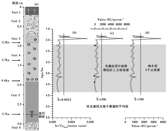
在纳木错流域的第四纪地质及高湖面沉积物分布特征的调查基础上,我们选择了湖泊东北部毗邻半岛的高湖面沉积为重点研究对象(图 2a)。剖面点的地理位置是30°52′N,90°53′E。在研究剖面附近存在一个明显的宽约10m的湖岸基岩侵蚀形成的古湖岸线(图 2b)。野外测量结果指示,纳木错这期古湖岸线高出现代湖面约30m左右(海拔高度约为4748m,见图 2c)。纳木错高湖面沉积剖面的采样厚度为296cm,其顶部和底部的海拔高度分别为4720.76m和4717.80m。在剖面上共计采集了4个光释光(OSL)测年样品(图 2d),采样深度分别为89cm、135cm、189cm和275cm(图 3a)[23]。

|
图 3 纳木错剖面岩性单元及高湖面时期湖水电导率重建 (a)纳木错剖面岩性单元;(b)纳木错剖面萝卜螺壳体化石Sr/Ca摩尔比[23];(c)本研究基于在青藏高原中南部湖泊面上建立的方程重建的纳木错高湖面时期的电导率;(d)本研究基于在纳木错建立的方程重建的纳木错高湖面时期的电导率 Fig. 3 Reconstructed electrical conductivity(EC)values of the Lake Nam Co during the high level period. (a)Lithologic units of the Lake Nam Co profile; (b)Sr/Ca molar ratio of Radix sp. fossil shells from the Lake Nam Co profile[23]; (c)Reconstructed EC of the Lake Nam Co during the high level period based on the relationship established in lakes of the south-central Tibetan Plateau; (d)Reconstructed EC of the Lake Nam Co during the high level period based on the specific relationship established in the Lake Nam Co |
Chen等[23]主要依据沉积物的颜色、结构、粒径和接触关系的变化,将纳木错沉积剖面划分为6个岩性单元(图 3a)。Unit 1(0~0.2m)为土壤层;Unit 2(0.20~0.75m)为坡积物层;Unit 3(0.75~0.86m)为过渡层;Unit 4(0.86~1.91m)为粘土层;Unit 5(1.91~2.96m)为粗砂层;Unit 6(2.96~?m)为砾石层[23]。在剖面深度为0.75~1.87m的范围内,存在萝卜螺壳体化石,但萝卜螺壳体化石主要分布在Unit 4中,而在过渡带中(Unit 3) 只有零星的出现。此外,值得注意的是,在Unit 4底部出现了一个萝卜螺壳体化石层(1.85~1.87m)。经鉴定,剖面中采集的大部分壳体化石为耳萝卜螺(Radix auricularia)(图 1a)。
萝卜螺是淡水中常见的螺类,在世界范围内分布广泛[29]。在我国的分布亦极其广泛,常见于包括青藏高原在内的广大地区的湖泊和河流中[30, 31]。萝卜螺的寿命约为一年[32],其壳体的矿物组成为文石。萝卜螺倾向于栖息在地势平坦、平静的浅水地带,如湖水、河水的回水区或湿地沼泽中[33]。其主要原因在于,萝卜螺在此环境下可以比较容易地获取营养物质和阳光。此外,Mischke等[34]在卡拉库里湖(Lake Karakul)的调查发现,现生萝卜螺分布的水深范围在5.7~22.2m。并且萝卜螺更倾向栖息于淡水或者低到中盐度的水体中[24]。
3.2 年代学分析样品及方法光释光测年被广泛应用于湖泊沉积物的测年[6, 35, 36]。本文沉积剖面4个样品的OSL年代测试在中国地震局地壳应力研究所地壳动力学重点实验室完成。细颗粒(4~11μm)石英样品光释光辐照和信号测量均在丹麦Risoe DA-20-C/D型热/光释光自动测量系统上完成。样品的天然释光等效剂量(即古剂量)测定采用简单多片再生法(SMAR)获得[37]。年代测试结果见图 3a:Unit 5~Unit 3形成的时期大约在距今6.1~1.8ka,处于中晚全新世时期[23];而高湖面时期沉积的粘土质细粒物质的形成年代大约为距今4.4~2.2ka(图 3a)[23]。
3.3 萝卜螺壳体微量元素、δ13C和δ18O分析样品及方法萝卜螺壳体的前处理流程是:使用细毛刷清除壳体上所有明显的无机物和有机物;之后将壳体置于5ml的离心管中,使用10%双氧水(H2O2)溶液浸泡壳体24小时去除散布的物质;再将离心管中倒入超纯水,利用超声波清洗,并用超纯水清洗至中性;之后放入60℃烘箱中干燥6小时。最后,利用玛瑙研钵将洁净的壳体研磨至200目以内,置于5ml离心管中密封保存。
壳体微量元素的测试方法为:称取约2mg的壳体样品,加入5ml 3%的超纯HNO3溶解。使用中国科学院青藏高原研究所的ICP-MS(X-7 series;Thermo Elemental)测量。Ca、Sr的检出限分别为0.003ppm和0.004ppb。测量精度<3%。
壳体δ13C和δ18O的测试在中国科学院地质与地球物理研究所新生代地质与环境重点实验室完成。最终结果以美国南卡罗来纳州白垩系皮狄组的拟箭石为参照标准,简写成PDB。每9个样品插一个标准样品(NBS-19),δ18O分析误差小于±0.06‰,δ13C分析误差小于±0.05‰。测试采用碳酸盐自动进样装置(KIEL CARBONATE DEVICE)与Finnigan MAT -253型质谱仪联机测试。壳体元素及同位素结果之前已经被发表[23, 33]。本文是基于此前发表的原始数据[23, 33],从湖泊水文状态演化的角度,对壳体元素及同位素结果进行重新解读;重建纳木错高湖面时期的电导率及水化学特征(δ18O和Sr/Ca);并结合地貌证据探讨纳木错高湖面时期的水位及水文状态。
4 结果与讨论 4.1 高湖面古湖水电导率(Paleo-EC)、δ18OPaleo-water和Sr/CaPaleo-water重建 4.1.1 高湖面古湖水电导率(Paleo-EC)重建基于高湖面沉积物的岩性(粒度等)、沉积物特征(磁化率、TIC和TOC等)、萝卜螺化石分布及萝卜螺化石壳体的δ13C、δ18O和Sr/Ca比值,Chen等[23]指出沉积剖面中的Unit 4连续沉积代表了纳木错稳定的高湖面沉积,并基于OSL测年结果,这期高湖面发育的时间大约在4.4~2.2ka期间。
本研究试图通过两种方法重建高湖面时期纳木错古湖水的电导率(Paleo-EC)。一种方法是基于Chen等[33]在青藏高原中南部多个湖泊而建立的萝卜螺壳体Sr/Cashell与其宿生湖水EC之间的相关关系方程(面上关系方程:Sr/Cashell=9×10-7×EC+0.0001;R2=0.71,n=14),利用纳木错剖面萝卜螺壳体化石的Sr/Cashell来重建(图 3b和3c)。采用该方法,本文重建的高湖面时期纳木错湖水Paleo-EC的变化范围是-190μs/cm至1029μs/cm,平均值是340μs/cm。由于纳木错现今湖水EC的平均值是1581μs/cm,这一重建出来的Paleo-EC值要比现代平均值低是符合预期的。然而,重建结果出现了3个负值(图 3c中黑色实心圆点),这说明利用青藏高原中南部多个湖泊而建立的萝卜螺壳体Sr/Cashell与其宿生湖水EC之间的关系来重建纳木错古湖水的Paleo-EC可能是不适用的。
另一种方法是基于在纳木错自身现生萝卜螺壳体Sr/Cashell与湖水EC的相关关系方程,利用剖面萝卜螺壳体化石的Sr/Cashell来重建。在纳木错,由5个样点得到的现生萝卜螺壳体Sr/Cashell与湖水EC的关系是:Sr/Cashell=2×10-6×EC-0.0002(n=5,R2=0.48)。高湖面时期纳木错湖水Paleo-EC的重建结果如图 3d,其变化范围是514μs/cm至1063μs/cm,平均值是753μs/cm,这一值要比现代平均值(1581μs/cm,见图 3c和3d)低,也是符合预期的,即高湖面时期湖水的电导率比现今低湖面时期低——这说明利用萝卜螺化石壳体的Sr/Cashell重建湖泊古湖水的Paleo-EC可能需要利用湖泊自身萝卜螺壳体与湖水EC建立的关系。由于纳木错湖泊巨大,本研究的采样点较少,要想比较准确的重建纳木错高湖面时期古湖水的Paleo-EC,需要更多的数据支持。
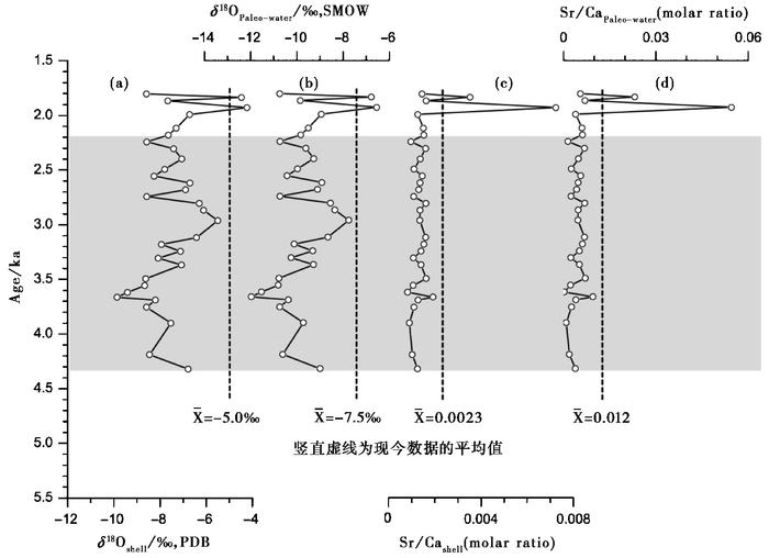
4.1.2 高湖面古湖水δ18OPaleo-water和Sr/CaPaleo-water重建本文基于Chen等[33]在青藏高原中南部多个湖泊而建立的萝卜螺壳体Sr/Cashell、δ18Oshell与其宿生湖水的Sr/Cawater、δ18Owater之间的相关关系方程(Sr/Cashell=0.118×Sr/Cawater+0.0008;R2=0.78,n=15;δ18Oshell-PDB=1.0361×δ18Owater+2.5409;R2=0.90,n=30),利用纳木错剖面萝卜螺化石壳体的δ18Oshell(图 4a)和Sr/Cashell(图 4c)[23],重建了纳木错高湖面时期古湖水的氧同位素(δ18OPaleo-water)和锶钙摩尔比(Sr/CaPaleo-water)(图 4b和4d)。

|
图 4 纳木错高湖面时期湖水δ18O和Sr/Ca摩尔比重建 (a)纳木错剖面萝卜螺壳体化石氧同位素[23];(b)重建的湖水的氧同位素;(c)纳木错剖面萝卜螺壳体化石Sr/Ca摩尔比[23];(d)重建的Sr/Ca摩尔比 Fig. 4 Reconstruction of δ18O and Sr/Ca molar ratio of the Lake Nam Co during the high level period. (a)δ18O of Radix sp. shells from the Lake Nam Co profile[23]; (b)Reconstructed δ18O of the Lake Nam Co wtaer; (c)Sr/Ca molar ratio of Radix sp. shells from the Lake Nam Co profile[23]; (d)Reconstructed Sr/Ca molar ratio of the Lake Nam Co water |
重建结果指示,纳木错高湖面时期古湖水的δ18OPaleo-water变化在-12.0‰至-7.8‰之间,平均值是-9.9‰(图 4b)。纳木错现代湖水的δ18Owater的平均值大约是-7.5‰(图 4b),重建的δ18OPaleo-water无论是变化范围还是平均值都是要比现代湖水的δ18Owater低。另外,纳木错高湖面时期古湖水Sr/CaPaleo-water的重建结果变化在0.0002至0.0095之间,平均值是0.0043(图 4d)。纳木错现代湖水的Sr/Cawater的平均值大约是0.012(图 4d),重建的Sr/CaPaleo-wate无论是变化范围还是平均值均比现代湖水的Sr/Cawater低。重建结果指示,纳木错在高湖面时期有着较充足的降水补给,或者是具有较低的蒸发强度。
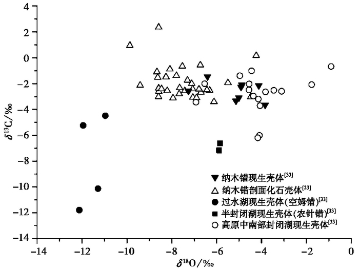
4.2 高湖面期古水文状态及古湖面高度探讨依据青藏高原湖泊中萝卜螺壳体及其宿生湖水的δ18O的研究结果,Taft等[25]指出湖水的δ18O值能够区分开放和封闭的湖盆。同时,他们的数据清楚的证实了,与封闭湖泊中萝卜螺现生壳体δ18O值相比,开放湖泊中萝卜螺现生壳体δ18O值要明显偏低[25]。此外,Chen等[33]之前的研究表明,青藏高原中南部湖泊中萝卜螺现生壳体δ18O主要反映其宿生湖水的δ18O(图 5)。因此,萝卜螺壳体的δ18O值能够用来了解其宿生水体的水文状态。

|
图 5 不同湖泊水文状态下萝卜螺壳体碳氧同位素的分布 Fig. 5 Distribution pattern of carbon and oxygen isotopic composition of Radix shells under various lake hydrological state |
本文依据湖泊水文状态,将青藏高原中南部湖泊划分为封闭湖、半封闭湖和过水湖;并进一步分析了萝卜螺现生壳体δ18O与其宿生湖泊水文状态的联系。封闭湖、半封闭湖(农针错[33])和过水湖(空姆错[33])现生壳体δ18O值的变化范围分别变化在-7.3‰至-0.9‰、-5.9‰至-5.8‰和-12.1‰至-10.9‰[33]之间(图 5)。结果表明,萝卜螺壳体的δ18O值随湖泊水文状态开放程度的提高而逐渐降低。本研究发现,封闭湖的现生壳体δ18O值是比较高的,而过水湖的现生壳体δ18O值是比较低的。在纳木错高湖面沉积剖面中,萝卜螺化石壳体的δ18O值的变化在-9.9‰至-4.2‰[23]之间。该δ18O数值范围大多介于过水湖(空姆错)现生壳体和封闭湖现生壳体δ18O值的中间状态(图 5),而与半封闭的农针错[33](图 5)有着类似的壳体δ18O值。农针错(28°53′N,90°24′E)是羊卓雍错西面附近的一个非常小的湖泊,现今处于半封闭状态,它经由一条小河而注入羊卓雍错,但是这条外流河流经常处于干涸状态。由此,我们推测纳木错在约4.4~2.2ka高湖面期间可能处于一种间歇性外流的状态。
另外一方面,在纳木错西北角,纳木错流域与其西面相邻的仁错流域之间为一个低矮的分水岭(图 6a),这一分水岭的最高点在丘贡附近,其海拔高度约为4738m(图 6b)。分水岭两侧的雄曲和那曲河分别注入纳木错和仁错。在分水岭区域,朱大岗等[39]曾发现了湖相与湖滨相沉积以及湖岸阶地与湖岸堤,从而确认了纳木错和仁错曾经是相互连通的一个大湖。纳木错和仁错的现今湖面海拔高度分别为4718m和4648m,而分水岭高出纳木错现今湖面约20m。因此,若纳木错高湖面时期湖面高出现今湖面20m时,达到海拔高度4738m时,即当纳木错的湖面海拔超过丘贡分水岭的海拔高度时,纳木错湖水就会经由雄曲-那曲而外流注入仁错(图 6)。

|
图 6 纳木错外溢通道 (a)分水岭(丘贡附近);(b)丘贡附近地形略图(参考1975年版1:10万比例尺地形图)[38] Fig. 6 The overflow channel of the Lake Nam Co. (a)The watershed between drainage basins(near Qiugong); (b)Topographic sketch map near Qiugong (refer to topographic map of 1︰00000 scale at 1975 versions)[38] |
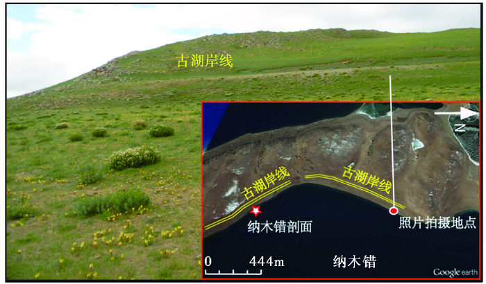
我们在野外调查中发现,研究剖面附近存在一个明显的宽约10m由湖岸基岩侵蚀所形成的古湖岸线(图 7)。野外测量的初步结果指示,纳木错这期古湖岸线高出现代湖面30m左右(图 2b和2c)。此外,基于纳木错附近的一个河湖相沉积剖面的介形虫水深转换函数,Schütt等[40]指出在4.2~2.8ka B.P.期间,纳木错湖面比现在湖面要高出+15m。Kasper等[41]通过对纳木错湖芯钻孔(NC08/01) 的研究,揭示在约4~2cal.ka B.P.纳木错发育了一期高湖面。他们利用介形虫水深转换函数得出,这期高湖面水面的高程要比现今湖面(4718m)高大约5~18m。综上所述,尽管纳木错这期高湖面的湖面绝对高度还存在争议。但是,假若古湖岸线与纳木错高湖面期相对应,基于古湖岸线的分布高程,我们可以大体推测出这一期高湖面的湖面水位应该位于现今湖面水位之上约30m左右。这一高湖面时期的湖面高程已经超过纳木错与仁错之间分水岭的高程。由此,纳木错的水文状态也可能发生了改变,即由一封闭湖泊而转变成外流湖泊。经由分水岭地区的雄曲-那曲河,纳木错湖水外溢注入仁错(图 6)。这一由湖盆流域地貌及古湖岸线分布高程所得到的结论,与上述基于萝卜螺壳体化石氧同位素的推论有着较好的一致性。因此,我们认为纳木错在高湖面时期(约4.4~2.2ka)可能存在间歇性外流。

|
图 7 纳木错剖面附近古湖岸线 Fig. 7 The paleo-shoreline near the investigated sediment profile at the Lake Nam Co |
Chen等[23]利用萝卜螺壳体化石的Sr/Ca、δ13C和δ18O从蒸发、降水、构造和冰川融水4个方面详细的分析了纳木错高湖面变化的机制,其认为纳木错这期高湖面的形成机制可能主要是该时期印度夏季风带来的降水增加所造成的;同时,该时期较弱的蒸发也可能扮演了重要的角色。
5 结论(1) 本研究认为利用萝卜螺化石壳体的Sr/Cashell重建湖泊古湖水的Paleo-EC可能需要利用本湖泊萝卜螺壳体与湖水EC建立的关系,而基于多个湖泊所建立的相关关系方程可能不适用。本文基于纳木错5个样点所得到的现生萝卜螺壳体Sr/Cashell与湖水EC的关系,重建了纳木错高湖面时期(约4.4~2.2ka)湖水的Paleo-EC。重建结果指示,Paleo-EC的变化范围为514μs/cm至1063μs/cm。本研究重建的纳木错高湖面时期湖水的δ18OPaleo-water的变化范围在-12.0‰至-7.8‰;另外,重建的纳木错高湖面时期湖水的Sr/CaPaleo-water的变化范围在0.0002至0.0095。
(2) 本文证实萝卜螺壳体δ18O与其宿生湖泊水文状态存在一定的关系。萝卜螺壳体的δ18O值随湖泊水文状态开放程度的提高而逐渐降低。在纳木错高湖面沉积剖面中,萝卜螺化石壳体的δ18O值的变化在-9.9‰至-4.2‰之间;这一数值范围指示纳木错在约距今4.4~2.2ka的高湖面期间可能处于一种间歇性外流状态。
(3) 纳木错流域与其西面相邻的仁错流域之间分水岭的海拔高度约为4738m。纳木错和仁错现今湖面的海拔高度分别为4718m和4648m。纳木错高湖面时期(约4.4~2.2ka)湖岸线地貌证据指示,古水位高度可能较现今湖面高出约30m左右;而这一湖面高度远高于纳木错流域与仁错流域之间分水岭的高度。因此,萝卜螺化石壳体δ18O及湖岸线地貌证据均指示,纳木错在高湖面期间可能存在间歇性外流,外溢湖水注入毗邻的仁错湖。
致谢 感谢刘月英老师在萝卜螺鉴定方面给予的极大帮助;感谢王君波博士、张继峰博士和黄磊在野外工作方面的帮助;感谢审稿人和杨美芳老师对本文提出的宝贵修改意见。
| 1 |
Chen Y, Zong Y, Li B et al. Shrinking lakes in Tibet linked to the weakening Asian monsoon in the past 8.2ka. Quaternary Research, 2013, 80(2): 189-198. DOI:10.1016/j.yqres.2013.06.008 |
| 2 |
Kong P, Na C, Brown R et al. Cosmogenic 10Be and 26 Al dating of paleolake shorelines in Tibet. Journal of Asian Earth Sciences, 2011, 41(3): 263-273. DOI:10.1016/j.jseaes.2011.02.016 |
| 3 |
Li D, Li Y, Ma B et al. Lake-level fluctuations since the Last Glaciation in Selin Co(lake), central Tibet, investigated using optically stimulated luminescence dating of beach ridges. Environmental Research Letters, 2009, 4(4): 1-10. |
| 4 |
赵希涛, 朱大岗, 严富华等. 西藏纳木错末次间冰期以来的气候变迁与湖面变化. 第四纪研究, 2003, 23(1): 41-52. Zhao Xitao, Zhu Dagang, Yan Fuhua et al. Climate change and lake-level variation of Nam Co, Xizang since the Last Interglacial stage. Quaternary Sciences, 2003, 23(1): 41-52. |
| 5 |
姜大伟, 何仲太, 刘睿等. 岱海盆地南缘地貌陡坎的成因分析. 第四纪研究, 2013, 33(3): 445-460. Jiang Dawei, He Zhongtai, Liu Rui et al. A study of the surficial scarps in the south rim of Daihai Basin. Quaternary Sciences, 2013, 33(3): 445-460. |
| 6 |
隆浩, 张静然. 晚第四纪湖泊演化光释光测年. 第四纪研究, 2016, 36(5): 1191-1203. Long Hao, Zhang Jingran. Luminescence dating of Late Quaternary lake-levels in Northern China. Quaternary Sciences, 2016, 36(5): 1191-1203. |
| 7 |
郑绵平, 袁鹤然, 赵希涛等. 青藏高原第四纪泛湖期与古气候. 地质学报, 2006, 80(2): 169-180. Zheng Mianping, Yuan Heran, Zhao Xitao et al. The Quaternary Pan-lake(Overflow)period and paleoclimate on the Qinghai-Tibet Plateau. Acta Geologica Sinica, 2006, 80(2): 169-180. |
| 8 |
朱立平, 王君波, 林晓等. 西藏纳木错深水湖芯反映的8.4ka以来气候环境变化. 第四纪研究, 2007, 27(4): 588-597. Zhu Liping, Wang Junbo, Lin Xiao et al. Environmental changes reflected by core sediments since 8.4ka in Nam Co, central Tibet of China. Quaternary Sciences, 2007, 27(4): 588-597. |
| 9 |
Gasse F, Arnold M, Fontes J-C et al. A 13, 000-year climate record from western Tibet. Nature, 1991, 353(6346): 742-745. DOI:10.1038/353742a0 |
| 10 |
Gu Zhaoyan, Liu Jiaqi, Yuan Baoyin et al. Monsoon variations of the Qinghai-Xizang Plateau during the last 12, 000 years——Geochemical evidence from the sediments in the Siling Lake. Chinese Science Bulletin, 1993, 38(7): 577-581. |
| 11 |
Mügler I, Gleixner G, Günther F et al. A multi-proxy approach to reconstruct hydrological changes and Holocene climate development of Nam Co, central Tibet. Journal of Paleolimnology, 2010, 43(4): 625-648. DOI:10.1007/s10933-009-9357-0 |
| 12 |
Wei K, Gasse F. Oxygen isotopes in lacustrine carbonates of West China revisited:Implications for post glacial changes in summer monsoon circulation. Quaternary Science Reviews, 1999, 18(12): 1315-1334. DOI:10.1016/S0277-3791(98)00115-2 |
| 13 |
Wolin J A, Stone J R. Diatoms as indicators of water-level change in freshwater lakes. In:Stoermer E F, Smol J P eds. The Diatoms Applications to the Environmental and Earth Sciences. Cambridge:Cambridge University Press, 2010. 174~185 https://www.cabdirect.org/cabdirect/abstract/20103313515
|
| 14 |
Wu Y, Lücke A, Jin Z et al. Holocene climate development on the central Tibetan Plateau:A sedimentary record from Cuoe Lake. Palaeogeography, Palaeoclimatology, Palaeoecology, 2006, 234(2): 328-340. |
| 15 |
凌光久, 贾玉连, 马春梅等. 内蒙古黄旗海中晚全新世(3580-1630cal.a B.P.)气候环境记录. 第四纪研究, 2016, 36(2): 257-267. Ling Guangjiu, Jia Yulian, Ma Chunmei et al. Mid-Late Holocene(3580-1630cal.a B.P.)climate and environment records from Huangqihai Lake in Inner Mongolia. Quaternary Sciences, 2016, 36(2): 257-267. |
| 16 |
范佳伟, 肖举乐, 温锐林等. 达里湖沉积粒度组分-湖面状况定量模型. 第四纪研究, 2016, 36(3): 612-622. Fan Jiawei, Xiao Jule, Wen Ruilin et al. A model for the linkage between grain-size component in the Dali Lake sediments and lake level status. Quaternary Sciences, 2016, 36(3): 612-622. |
| 17 |
姜雅娟, 王维, 马玉贞等. 内蒙古鄂尔多斯高原泊江海子全新世气候变化初步研究. 第四纪研究, 2014, 34(3): 654-665. Jiang Yajuan, Wang Wei, Ma Yuzhen et al. A preliminary study on Holocene climate change of Ordos Plateau, as inferred by sedimentary record from Bojianghaizi Lake of Inner Mongolia, China. Quaternary Sciences, 2014, 34(3): 654-665. |
| 18 |
孙博亚, 岳乐平, 赖忠平等. 14ka B.P.以来巴里坤湖区有机碳同位素记录及古气候变化研究. 第四纪研究, 2014, 34(2): 418-424. Sun Boya, Yue Leping, Lai Zhongping et al. Paleoclimate changes recorded by sediment organic carbon isotopes of Lake Barkol since 14ka B.P. Quaternary Sciences, 2014, 34(2): 418-424. |
| 19 |
侯居峙, William J D' Andrea, 柳中晖. 湖泊碳库效应对青藏高原气候变化解释的影响探讨. 第四纪研究, 2012, 32(3): 441-453. Hou Juzhi, William J D'Andrea, Liu Zhonghui. Geochronlogical limitations for interpreting the paleoclimatic history of the Tibetan Plateau. Quaternary Sciences, 2012, 32(3): 441-453. |
| 20 |
Herzschuh U. Palaeo-moisture evolution in monsoonal Central Asia during the last 50, 000 years. Quaternary Science Reviews, 2006, 25(1): 163-178. |
| 21 |
Lai Z, Kaiser K, Brückner H. Luminescence-dated aeolian deposits of Late Quaternary age in the southern Tibetan Plateau and their implications for landscape history. Quaternary Research, 2009, 72(3): 421-430. DOI:10.1016/j.yqres.2009.07.005 |
| 22 |
朱大岗, 赵希涛, 孟宪刚等. 西藏纳木错第四纪湖相地层划分及纳木错群的建立. 地质通报, 2002, 21(11): 708-716. Zhu Dagang, Zhao Xitao, Meng Xiangang et al. Division of Quaternary lacustrine strata in the Nam Co area and establishment of Nam Co group in Tibet. Geological Bulletin of China, 2002, 21(11): 708-716. DOI:10.3969/j.issn.1671-2552.2002.11.003 |
| 23 |
Chen F, Feng J L, Hu H P et al. Potential forcing mechanisms of Holocene lake-level changes at Nam Co, Tibetan Plateau:Inferred from the stable isotopic composition of shells of the gastropod Radix. The Holocene, 2016, doi:10.1177/0959683616670247
|
| 24 |
Taft L, Wiechert U, Riedel F et al. Sub-seasonal oxygen and carbon isotope variations in shells of modern Radix sp.(Gastropoda)from the Tibetan Plateau:Potential of a new archive for palaeoclimatic studies. Quaternary Science Reviews, 2012, 34(1): 44-56. |
| 25 |
Taft L, Wiechert U, Zhang H et al. Oxygen and carbon isotope patterns archived in shells of the aquatic gastropod Radix:Hydrologic and climatic signals across the Tibetan Plateau in sub-monthly resolution. Quaternary International, 2013, 290-291(2): 282-298. |
| 26 |
Taft L, Mischke S, Wiechert U et al. Sclerochronological oxygen and carbon isotope ratios in Radix(Gastropoda)shells indicate changes of glacial meltwater flux and temperature since 4, 200cal yr BP at Lake Karakul, eastern Pamirs(Tajikistan). Journal of Paleolimnology, 2014, 52(1-2): 27-41. DOI:10.1007/s10933-014-9776-4 |
| 27 |
Zhu L, Lü X, Wang J et al. Climate change on the Tibetan Plateau in response to shifting atmospheric circulation since the LGM. Scientific Reports, 2015, 5: 13318. DOI:10.1038/srep13318 |
| 28 |
朱大岗, 孟宪刚, 赵希涛等. 纳木错湖相沉积与藏北高原古大湖. 地球学报, 2001, 22(2): 149-155. Zhu Dagang, Meng Xiangang, Zhao Xitao et al. Nam Tso lacustrine sediments and the ancient big lake in northern Tibet Plateau. Acta Geoscientia Sinica, 2001, 22(2): 149-155. |
| 29 |
Huňová K, Kašný M, Hampl V et al. Radix spp.:Identification of trematode intermediate hosts in the Czech Republic. Acta Parasitologica, 2012, 57(3): 273-284. |
| 30 |
刘月英, 张文珍, 王跃先等. 中国经济动物志:淡水软体动物. 北京: 科学出版社, 1979, 49-57. Liu Yueying, Zhang Wenzhen, Wang Yuexian et al. Chinese Economic Animal Records:Freshwater Mollusk. Beijing: Science Press, 1979, 49-57. |
| 31 |
von Oheimb P V, Albrecht C, Riedel F et al. Freshwater biogeography and limnological evolution of the Tibetan Plateau——Insights from a plateau-wide distributed gastropod taxon(Radix spp. PloS One, 2011, 6(10): 1-9. |
| 32 |
Young M R. The life cycles of six species of freshwater molluscs in the Worcester-Birmingham canal. Journal of Molluscan Studies, 1975, 41(6): 533-548. |
| 33 |
Chen F, Feng J L, Hu H P. Relationship between the shell geochemistry of the modern aquatic gastropod Radix and water chemistry of lakes of the Tibetan Plateau. Hydrobiologia, 2016, 771(1): 239-254. DOI:10.1007/s10750-015-2634-1 |
| 34 |
Mischke S, Rajabov I, Mustaeva N et al. Modern hydrology and Late Holocene history of Lake Karakul, eastern Pamirs(Tajikistan):A reconnaissance study. Palaeogeography, Palaeoclimatology, Palaeoecology, 2010, 289(1): 10-24. |
| 35 |
李芳亮, 魏海涛, 范育新等. JYZ11A钻孔记录的居延泽演化历史. 第四纪研究, 2015, 35(1): 180-191. Li Fangliang, Wei Haitao, Fan Yuxin et al. The drill core JYZ11A revealed lake evolution in Juyanze basin, Inner Mongolia. Quaternary Sciences, 2015, 35(1): 180-191. |
| 36 |
赵丽媛, 鹿化煜, 张恩楼等. 敦煌伊塘湖沉积物有机碳同位素揭示的末次盛冰期以来湖面变化. 第四纪研究, 2015, 35(1): 172-179. Zhao Liyuan, Lu Huayu, Zhang Enlou et al. Lake-level and paleoenvironment variations in Yitang Lake(Northwestern China)during the past 23ka revealed by stable carbon isotopic composition of organic matter of lacustrine sediments. Quaternary Sciences, 2015, 35(1): 172-179. |
| 37 |
王旭龙, 卢演俦, 李晓妮. 细颗粒石英光释光测年:简单多片再生法. 地震地质, 2005, 27(4): 615-623. Wang Xulong, Lu Yanchou, Li Xiaoni. Luminescence dating of fine-grained quartz in chinese loess-simplified multiple aliquot regenerative-dose(MAR)protocol. Seismology and Geology, 2005, 27(4): 615-623. |
| 38 |
中国人民解放军总参谋部测绘局. 1︰ 10万地形图保吉区幅. 北京: 星球地图出版社, 1975. The Surveying and Mapping Bureau of the General Staff of the Chinese People's Liberation Army. Topographic Map of 1︰ 100000 Scale at Baoji District. Beijing: Planet Map Publishing House, 1975. |
| 39 |
朱大岗, 赵希涛, 孟宪刚等. 西藏纳木错与仁错-久如错连通和藏北高原古大湖的发现. 中国地质, 2001, 28(12): 40-42. Zhu Dagang, Zhao Xitao, Meng Xiangang et al. The connection of Ring Co-Jiuru Co with Nam Co of Tibet, and the discovery of an ancient large lake in the northern Tibetan Plateau. Chinese Geolgy, 2001, 28(12): 40-42. DOI:10.3969/j.issn.1000-3657.2001.12.009 |
| 40 |
Schütt B, Berking J, Frechen M et al. Late Quaternary transition from lacustrine to a fluvio-lacustrine environment in the north-western Nam Co, Tibetan Plateau, China. Quaternary International, 2010, 218(1-2): 104-117. DOI:10.1016/j.quaint.2009.05.009 |
| 41 |
Kasper T, Frenzel P, Haberzettl T et al. Interplay between redox conditions and hydrological changes in sediments from Lake Nam Co(Tibetan Plateau)during the past 4000 cal aBP inferred from geochemical and micropaleontological analyses. Palaeogeography, Palaeoclimatology, Palaeoecology, 2013, 392(7): 261-271. |
② Institute of Tibetan Plateau Research, Chinese Academy of Sciences, Beijing 100101;
③ University of Chinese Academy of Sciences, Beijing 100049)
Abstract
The paleo-lake level and paleohydrological reconstruction is one of the most challenging issues in lake investigation. On the Tibetan Plateau, many lakes are surrounded by multiple paleo-shorelines and exposed high level lake sediments. Nevertheless, the research on the high level lake sediments on the Tibetan Plateau is not sufficient. The Lake Nam Co(30°30'~30°55'N, 90°16'~91°03'E; 4718m a.s.l.) is located at the south-central part of the Tibetan Plateau. It is characterized by the semi-arid monsoon climate. Here, the exposed high level lake sediments(at 30°52'N and 90°53'E with 2.96m in thickness)and paleo-shoreline from the Lake Nam Co have been investigated. The top of the profile is 2.76m above the modern lake level. We found that the fossil shells of Radix are widely distributed in the exposed sediment profile from 0.76m to 1.87m depth. Most of these fossil shells are gastropoda Radix auricularia(Pulmonata, Lymnaeidae), while a few of the broken shells cannot be identified to species level. In this study, we refer to the Radix species as 'Radix sp.'. Based on the geochemical relationship between Radix sp. shells and its ambient water derived from lakes of south central Tibetan Plateau or the specific Lake Nam Co, the fossil shells of Radix sp. were used to reconstruct the paleo-electrical conductivity(Paleo-EC)and paleohydrochemical features(δ18OPaleo-water and Sr/CaPaleo-water) of the paleo-lake water during the high level period(ca.4.4~2.2ka)of the Lake Nam Co. The reconstructed Paleo-EC values of the paleo-lake water during the high lake level period of Nam Co were between 514μs/cm and 1063μs/cm. However, the results indicate the reconstructed Paleo-EC values of the paleo-lake water depended on the specific relationship between the Sr/Ca ratio of the Radix sp. shells and the EC of the lake water in Nam Co, rather than relationship built based on many various lakes in south central Tibetan Plateau. The reconstructed δ18 OPaleo-water and Sr/CaPaleo-water values of the paleo-lake water during the high level period of the Lake Nam Co were between -12.0 ‰ and -7.8 ‰, 0.0002 and 0.0095, respectively. Moreover, we confirm that the δ18Oshell values of Radix sp. significantly depend on hydrological status of lakes. Based on the δ18Oshell values of fossil Radix sp., we infer that the Lake Nam Co existed as a semi-closed lake during its high level period. On the other hand, the summit top of watershed between the Lake Nam Co basin and its neighboring Lake Ring Co basin is about 4738m a.s.l. The present lake water level of both lakes is 4718m a.s.l. and 4648m a.s.l., respectively. Near the study site, we found that the paleo-shoreline is ca.30m above the modern lake level, while paleo-water level of the Lake Nam Co had exceeded the altitude of watershed. In summary, based on the δ18Oshell values of fossil Radix sp., the reconstructed δ18OPaleo-water of the paleo-water body and the geomorphological evidence of paleo-shoreline, we infer that the Lake Nam Co may be intermittent overflow during its high level period, while the outflow water spilled into the neighboring Lake Ring Co basin. 2017, Vol.37

