② 中国地质调查局天津地质调查中心, 天津 300170)
气候变暖背景下,海平面上升是海岸带主要的社会经济灾害[1]。过去海平面变化是预测未来海平面变化的基础[2],而海平面变化又具有区域性[3],区域海平面变化和河流相互作用形成不同的海岸沉积和地貌类型[4]。中国东部全新世海面变化和河流相互作用塑造了滦河三角洲[4]、黄河三角洲[5~7]、长江三角洲[8~10]和珠江三角洲[11~13],并成为全新世海岸带研究的热点区域[14~17]。海湾区域因缺少人类可利用的资源环境,其研究程度较低,但却是以海洋动力为主形成的海岸沉积类型,记录的海平面变化信息可能更为丰富。渤海湾西北部海洋和少泥沙河流相互作用,形成以牡蛎礁为特征的滨海平原,未形成较大三角洲[18, 19]。因此,研究该区域全新世海侵类型和范围,可以为预测海湾型海侵提供依据[20, 21]。本文根据渤海湾西北岸HG01孔微体古生物的垂向分布特征,及对沉积环境的指示作用,结合沉积特征,重建渤海湾西北岸晚更新世以来的沉积环境演化过程。
1 区域地质概况渤海湾西北岸指位于海河以北的蓟运河、潮白河下游地区(图 1)。该区地势低平,洼淀零散。蓟运河和潮白河之间发育多道牡蛎礁[18, 19],形成牡蛎礁平原。蓟运河以东区域较少牡蛎礁分布,仅有大吴庄牡蛎礁[22],多数区域为陡河、沙河等冲积形成的泛滥平原。陡河以东区域则为不同时期的滦河冲积扇-三角洲[4]。

|
图 1 渤海湾沿岸地貌简图和HG01孔位置 Fig. 1 The geomorphologic map of coast in Bohai Bay and the location of HG01 borehole |
晚更新世,渤海湾沿岸发生3次海侵,因年代学的问题,晚更新世的海侵时代存在一些争议。但全新世海侵依据可靠的14C年龄,基本发生在9.0cal.ka B.P.以来,并于7.1~7.4cal.ka B.P.发生最大海侵[23];全新世地层厚约17~20m[24]。
2 材料与方法 2.1 研究材料HG01钻孔位于河北省唐山市丰南区唐坊镇(39°28′21″N,118°01′16″E) (图 1),距离现代海岸线约28km,孔口高程2.3m,孔深80.0m,其中0~0.5m为耕植土。本文所研究的沉积物样品采自20.0m以浅的钻孔剖面中,根据岩性变化,以20~40cm不等间距取样,共采集样品85个,具体取样位置见图 2。

|
图 2 HG01孔有孔虫群组合分布及优势属种分布特征 Fig. 2 The distribution of benthic foraminiferal assemblages and dominant species in the HG01 borehole |
对HG01孔沉积物样品进行了有孔虫和介形类微体古生物化石分析鉴定和定量统计。从每个沉积物样品中称取20g干样,用纯净水浸泡,在不易分散的样品中,加入几滴双氧水(H2O2),样品充分散开后,用240目(孔径0.063mm)标准铜筛冲洗,筛上部分烘干后,在双目实体显微镜下进行挑选、鉴定与定量统计。原则上每个样品中,有孔虫与介形类的数量总和,统计不少于300个壳体;部分有孔虫和介形类微体化石含量丰富的样品,先采用缩分法进行缩分,不足300个壳体的样品则全样统计。有孔虫鉴定标准主要参考何炎等[25](1965)、郑守仪等[26](1978)和汪品先等[27](1988)相关文献,介形类鉴别标准主要参考侯佑堂等[28](2007)相关文献。统计结束后,分别计算各类微体化石的丰度和简单分异度。
2.2.2 年龄测试选取HG01孔中有机质含量较多的样品,利用纯净水浸泡分散,部分样品用超声波清洗机振荡分散,过180目筛去掉泥质部分,在50倍实体显微镜下挑选其中的炭化植物残片和白小旋螺等化石进行加速器质谱(accelerator mass spectrometry,简称AMS)14C测年,实验在美国BETA实验室完成,除17.1m处测得的>43500a B.P.未校正外,其余结果均进行了校正[29, 30](表 1)。结果表明20.0m以浅的钻孔剖面覆盖了晚更新世晚期以来的时间段。
| 表 1 HG01孔AMS 14C年代测试结果 Table 1 Results of AMS 14C dating in the HG01 borehole |
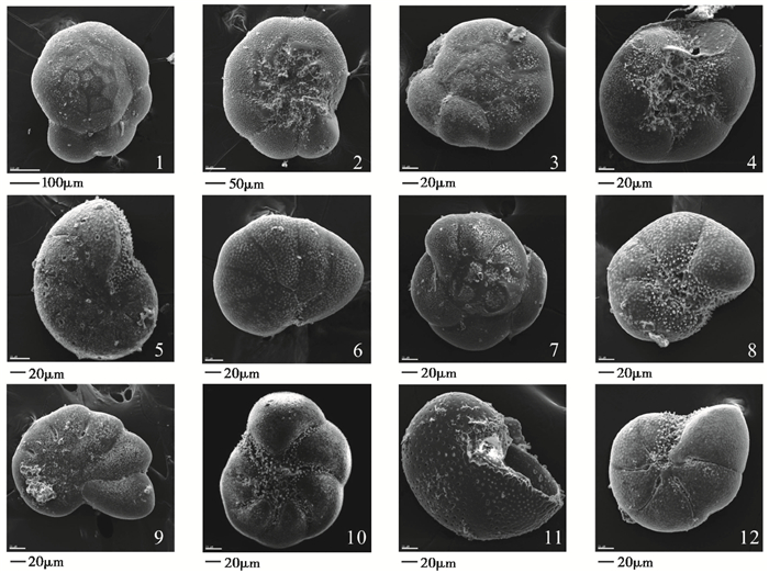
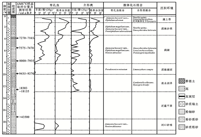
HG01孔20m以浅0.5~12.9m和17.0~19.4m见有微体化石,其中1.3~8.2m微体化石连续分布,壳体保存良好,个别壳体表面被腐蚀成棕黄色。该层段共见有孔虫24属65种,以Ammonia beccarii (Linné) vars.(毕克卷转虫变种)、Elphidium magellanicum(Heron-Allen and Earland)(缝裂希望虫)、Nonion akitaense (Asano)(秋田九字虫)为优势属种,平均含量占出现种群总量的58 %;其他常见种有Nonion glabrum (Ho,Hu et Wang)(光滑九字虫)、A. granuloumbilica (S. Y. Zheng)(粒脐卷转虫)、Cribrononion incertum (Williamson)(易变筛九字虫)、Pseudononionella variabilis(S.Y. Zheng)(多变假小九字虫)、Elphidiella kiangsuensis(Ho,Hu et Wang)(江苏小希望虫)、A. beccarii(Linné)(毕克卷转虫)、A. flevensis(Hofker)(显脐卷转虫)、Pseudononion oinomikadoi(Matsunaga)(扁假九字虫)、Protelphidium tuberculatum(d′Orbigny)(具瘤先希望虫)和Cribrononion subincertum(Asano)(亚易变筛九字虫)等(图 3)。各层位有孔虫丰度变化大,最高值3808枚/20g,最低值0枚/20g,平均为210枚/20g (图 2)。

|
图 3 HG01孔常见有孔虫化石 1. Ammonia beccarii (Linné),背视;2. Ammonia beccarii (Linné),腹视;3. Ammonia beccarii(Linné) vars.,背视;4. Ammonia beccarii(Linné) vars.,腹视;5. Cribrononion incertum(Williamson),侧视;6. Pseudononion oinomikadoi(Matsunaga),侧视;7. Ammonia flevensis (Hofker),背视;8. Elphidium magellanicum(Heron-Allen and Earland),侧视;9. Pseudononionella variabilis(S. Y. Zheng),侧视;10. Protelphidium tuberculatum (d'Orbigny),侧视;11. Elphidiella kiangsuensis(Ho,Hu et Wang),侧视;12. Cribrononion subincertum(Asano),侧视 Fig. 3 The common foraminiferal species of the HG01 borehole |
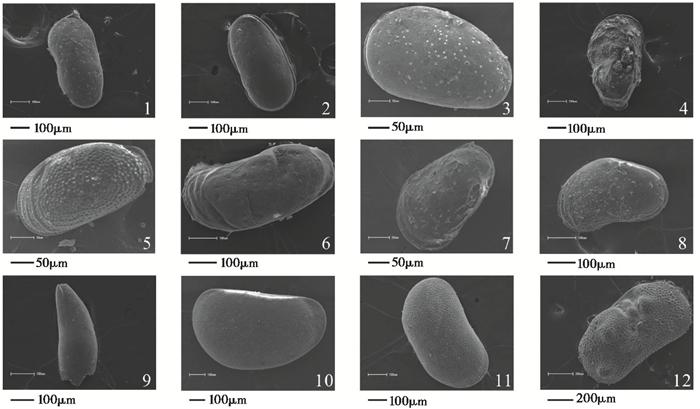
介形类化石出现层位与有孔虫大致相同,共见27属39种,绝大部分为海相介形类,以Sinocytheridea latiovata(Hou et Chen)(宽卵中华美花介)、S. longa(长中华美花介)、Loxoconcha ocellata(Ho)(眼点弯贝介)、Tanella opima(Chen)(丰满陈氏介)为优势属种,共占出现种群的70.3 %。其他常见种有Limnocythere compta(Lin)(优美湖花介)、Eucythere serrata(Zhao)(锯齿真花介)、Trachyleberis scabrocuneata(Brady)(粗楔粗面介)、Leptocythere ventridivosa(Chen)(腹结细花介)、S. impressa(Brady)(凹陷中华美花介)、Spinileberis furuyaensis(Ishizaki et Kato)(古屋刺面介)、Albileberis sinensis(Hou)(中华洁面介)和Pontocypris mytiloides(拟淡菜海星介)等。另外,在10~12.9m处,见有少量陆相介形类Candoniella albicans (Brady)(纯净小玻璃介)、C. suzini schneider(苏氏小玻璃介)、Ilyocypris bradyi Sars (布氏土星介)(图 4)。各层位丰度变化也比较大,最高684瓣/20g,最低0瓣/20g,平均为63瓣/20g (图 5)。

|
图 4 HG01孔常见介形类化石 1. Sinocytheridea impressa(Brady),背视;2. Sinocytheridea longa(Hou et Chen),背视;3. Loxoconcha ocellata(Ho),背视;4. Trachyleberis scabrocuneata(Brady),背视;5. Tanella opima(Chen),背视;6. Leptocythere ventridivosa(Chen),背视;7. Spinileberis furuyaensis (Ishizaki et Kato),背视;8. Albileberis sinensis(Hou),背视;9. Pontocypris mytiloides,背视;10. Limnocythere compta(Lin),背视;11. Candoniella albicans (Brady),背视;12. Ilyocypris Kaifengensis,背视 Fig. 4 The common ostracod species of the HG01 borehole |

|
图 5 HG01孔介形类组合分布及优势属种分布特征 Fig. 5 The distribution of ostracod assemblages and dominant species in the HG01 borehole |
根据微体化石的丰度、分异度以及优势属种的变化特征(图 2和5),结合地层岩性特征及年代测试结果(表 1),自下而上将HG01孔划分出6个生物地层组合层段,分别命名为化石组合Ⅰ~Ⅵ(图 2和5),以及一个化石间隔带(埋深17.0~12.9m)。
埋深17.0~12.9m未见微体化石,为化石间隔带。该层段岩性主要为黄色、橄榄灰色、深灰棕色、深灰色粉砂质泥、砂质粉砂、粉砂质砂,下部含钙质结核,推测为末次盛冰期广泛发育的硬粘土层[31];中部15.1~14.2m处含少量有机质斑点和钙质斑点,发育泥裂。自下而上,颜色变深,反映了区域逐渐积水成泽的特征,应为泛滥平原环境。
4.1 组合Ⅰ埋深19.4~17.0m。岩性主要为橄榄黄色泥质粉细砂,夹泥质条带,含铁锰质结核和钙质结核,上部含贝壳碎片,以牡蛎为主。本层段17.1m处,以牡蛎为材料的AMS 14C年龄大于43500a B.P.。
该组合有孔虫丰度变化范围为0~114枚/20g,简单分异度小于10,主要为A. beccarii vars.和N. akitaense,所占比例为54 %~71 %,两者均为世界上分布最广的广盐性种类,多见于滨海边缘环境[32]。其他常见分子有A. granuloumbilica、A. multicella和N. glabrum。本组合未见介形类,有孔虫壳体相对较小,以卷转虫属占绝对优势,磨损壳体常见,表明这些有孔虫是再搬运的产物,样品间的丰度、分异度变化较大,可能是由于水动力较强所致,为河口沙咀相沉积环境。
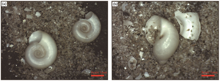
4.2 组合Ⅱ埋深12.9~10.0m。岩性主要为黑灰色、深灰色粉砂质泥、泥夹砂质粉砂,含有机质斑点和淡水腹足类Cyraulus albus(白小旋螺)(图 6a)和Para fossarulus(沼螺)(图 6b),上部10.9~10.2m处,含少量钙质结核,钙核大小为0.2×0.3~1.5×1.0cm。在12.6m处,以白小旋螺为材料的AMS 14C校正年龄为18385~18135cal.a B.P.。

|
图 6 渤海湾西北岸HG01钻孔12.6m (a)和12.4m (b)样品显微镜下>0.15mm颗粒分布 Fig. 6 Grain size distribution (>0.15mm) of sample 12.6m (a) and 12.4m (b) in borehole HG01 under microscope |
该组合仅含有C. albicans、C. suzini schneider、I. bradyi Sars等陆相介形类分子,丰度变化在0~31瓣/20g,平均7瓣/20g,简单分异度在1~3之间。C. albicans和C. suzini schneider主要生活在植物和藻类的流动水体中,I. bradyi主要生活在清澈碱性固定水体中的泥质底质中[33]。该组合特征代表淡水沼泽环境。
4.3 组合Ⅲ埋深10.0~8.2m。岩性主要为黑色、深灰色泥、粉砂质砂,含弱钙质胶结和有机质斑点,中部夹薄层状泥,含少量炭屑。在9.9m处,以炭化植物残片为材料的AMS 14C校正年龄为9435~9270cal.a B.P.。
该层段化石数量极少,种类单调。有孔虫丰度小于3枚/20g,简单分异度小于2。介形类丰度变化范围为0~7瓣/20g,简单分异度0~3,以L. compta为主要分子(图 5),反映了内陆湖盆或陆缘近海湖盆等环境[28]。本层段上部样品中零星分布少量L. ocellata和T. opima。淡水介形类和海相介形类共存,反映滨海湖沼相沉积环境。
4.4 组合Ⅳ埋深8.2~3.5m。岩性主要为深黑灰色、深灰色、深绿灰色泥、含泥粉细砂,本层段富含有机质,下部含炭屑,有机质含量较高;上部含大量炭化植物根系,3.8~3.9m为泥炭层,4.0~5.6m处含少量贝壳碎屑。在7.8m处,以炭化植物残片为材料的AMS 14C校正年龄为8000~7935cal.a B.P.;5.6m和3.9m处以炭化植物残片为材料的AMS 14C校正年龄分别为7575~7470cal.a B.P.和7270~7165cal.a B.P.。
该组合化石的丰度、分异度变化较大,从下部至上部整体呈上升趋势。有孔虫丰度变化范围为0~1192枚/20g,简单分异度在0~25之间,以A. beccarii vars.、E. magellanicum和N. akitaense为主,占0~59 %;其他常见种有E. kiangsuensis、P. variabilis、A. flevensis和N. glabrum。介形类丰度为0~292瓣/20g,分异度在0~17之间,以S. latiovata、L. ocellata和P. mytiloides等广温、广盐类型为优势种,占0~80 %,其他有Pontocypris mytiloides、S. longa和T. opima等半咸水-广盐类型[34]。其中,4.8~3.5m的样品中,见有大量T. scabrocuneata。
该层沉积物颜色以灰色为主,颗粒较细,质地均一,且多海相微体化石,反映潟湖相沉积环境。
4.5 组合Ⅴ埋深3.5~1.3m。岩性主要为灰棕色、深黄棕色泥、泥夹粉砂质砂,含锈染、螺碎片和锰质斑点。
该组合微体化石的丰度和分异度最大,有孔虫丰度变化范围为194~3808枚/20g,简单分异度在19~45之间,以E. magellanicum、A. beccarii vars.和Protelphidium tuberculatum(具瘤先希望虫)为主,占11 %~66 %,其中E. magellanicum在渤海水深大于20m的海域出现率比较高[35],在此可能指示了较强的海洋搬运动力。另外还见有C. incertum、N. akitaense、P. oinomikadoi等,代表了广生、广温、广盐环境。介形类丰度变化范围为260~736瓣/20g,分异度在8~20之间,以T. opima和S. latiovata为优势种,占0~80 %,以L. ocellata、L. ventridivosa和E. serrata为主要分子。
该层沉积物颜色渐黄,粒度较粗,多海相微体化石,可能反映为滨海水动力较强的滨岸沙坝沉积。
4.6 组合Ⅵ埋深1.3~0.5m。岩性主要为深黄棕色泥,含螺碎片和锰质斑点,含少量钙质斑点和弱还原斑。
该组合从下部至上部,微体化石的丰度和分异度呈降低的趋势。有孔虫丰度变化范围为39~2852枚/20g,简单分异度在11~25之间,以A. beccarii vars.、Elphidium advenum(异地希望虫)为主,占29 %~36 %;A. beccarii vars.为典型的广温广盐种,E. Advenum也是广温广盐种,主要生活在水深0~10m处的沿岸浅海环境[36]。其他有P. tuberculatum和Buccella frigida(冷水面颊虫)。介形类丰度变化范围为18~676瓣/20g,简单分异度在4~13之间,以T. opima和L. ocellata为主要分子,占40 %左右,其他重要分子有L. ventridivosa、S. latiovata和L. binhaiensis。本层段上部见有少量陆相介形类I. bradyi和I. kaifengsis(开封土星介)。
该层沉积物颜色为黄棕色,具有氧化还原特征,且海相和淡水微体化石共存,反映了强海相性海陆过渡相沉积,为潮上带沉积环境。
5 讨论有孔虫、介形类指示了与海平面变化相关的沉积环境,海平面变化不同的时期形成不同的沉积环境(图 7)。

|
图 7 HG01钻孔晚更新世以来的沉积环境演化特征 Fig. 7 Sedimentary environment evolution of the HG01 borehole in the northwest of Bohai Bay since Late Pleistocene |
渤海湾沿岸广泛存在第二海相层,其时代略有争议。依据有机质的14C年龄,其年龄为24~39ka B.P.,对应MIS 3阶段晚期[37];而依据OSL年龄,其时代可能为MIS 3或MIS 5[38~40];渤海湾西岸第二海相层中底部白小旋螺的年龄46.9~44.7cal.ka B.P.,上部砂层的OSL年龄为33.5~36.2ka B.P.[41],海相层中的贝壳年龄多大于43.5ka B.P.[42]。HG01孔第二海相上部牡蛎碎片AMS 14C年龄测试结果大于43.5ka B.P.。
HG01孔第二海相层埋深17.0~19.4m,为河口沙咀相沉积。渤海湾沿岸第二海相层基本为基底泥炭-海相层-河流相的沉积模式[24]。HG01孔仅有上部河流相,缺失基底泥炭和海相层,说明当时MIS 3阶段海侵在该区域较弱,以河流堆积为主。
5.2 末次冰消期初期(埋深17.0~10.0m,18.0~11.4cal.ka B.P.)末次冰消期初期,指末次盛冰期至新仙女木冷期。HG01孔埋深17.0~12.9m下部含有的弱钙质淀积应对应区域末次盛冰期广泛发育的硬粘土[31],未见微体化石。向上沉积物颜色渐深,至12.9m出现淡水介形类,反映了区域逐渐由泛滥平原积水,形成淡水沼泽。淡水沼泽中的白小旋螺的AMS 14C年龄为18385~18135cal.a B.P.,明显老于地层的时代,可能白小旋螺具有碳库效应。埋深12.9~10.0m,介形类丰度减少;上部埋深10.9~10.2m含少量钙质淀积结核,说明该时期沼泽经历了水位降低,区域冷干的环境使得沉积物中钙质淋溶和淀积,因此推断该层顶部对应新仙女木冷期。
该时期区域沉积物向上变细,颜色渐灰,反映了积水成泽的过程。此时海岸线已达到山东半岛北部[43],海水并未影响到该区域,区域沉积主要受到气候变化影响。
5.3 早全新世(埋深10.0~8.2m,11.4~8.0cal.ka B.P.)早全新世,HG01孔为滨海湖沼,并未形成海相层。
11.4~11.6cal.ka B.P.,海岸线位于山东半岛北部[43],高程为-40~-60m[44];10.2cal.ka B.P.时,位于渤海中部,高程为-25.8m[45];9.0cal.ka B.P.时,位于现代黄河三角洲北部的水下三角洲处,高程为-23.7[6];8.7cal.ka B.P.时,位于渤海湾西岸,高程约为-11.1m[7];海岸线于8.0cal.ka B.P.时到达HG01孔,高程为-5.5m。因区域广泛,构造差异较大,本次不讨论海平面上升速率,但也可以反映早全新世海平面上升的过程。
早全新世气候暖湿[46, 47],降水丰沛。伴随着海平面的上升,区域积水更深,出现海相有孔虫和淡水的L. Compta,形成滨海湖沼。
5.4 中全新世(埋深8.2~1.3m,8.0~6.0cal.ka B.P.)中全新世,HG01孔为潟湖和滨海砂坝相,以海岸带相为主。
8.0cal.ka B.P.时,海水入侵到HG01孔,并形成潟湖;至7.2cal.ka B.P.,主要为潟湖相沉积,有孔虫和介形类的分异度和丰度均相对一致,其中的高值(埋深6.0~7.3m)对应粉细砂,可能为潟湖通海的潮沟。微体化石和沉积物均具有相对匀质均一,反映了潟湖沉积的速率和海面上升的速率基本一致。该时期海平面上升速率为4.9m/ka,其中7.5~8.0cal.ka B.P.时,速率为4.4m/ka;7.2~7.5cal.ka B.P.时,速率为5.7m/ka,可能对应7.6cal.ka B.P.时期海平面快速上升事件[48]。
7.2cal.ka B.P.之后,随着海侵作用的增强,潟湖不断向内陆移动,海水侵蚀原始地表的沉积物在海岸线附近形成滨海砂坝。渤海湾西岸在7.1~7.6cal.ka B.P.形成最大海侵[7],渤海湾西北岸在7.0cal.ka B.P.也达最大海侵[49]。大约6.0cal.ka B.P.后,渤海湾沿岸古黄河三角洲、滦河三角洲开始发育,海岸线明显向海洋推进[4, 23],沿岸流携带沉积物沉积于此,逐渐成陆。据此,判断滨海砂坝时代应为7.2~6.0cal.ka B.P.。
5.5 中晚全新世(埋深1.3~0.5m,6cal.ka B.P.至今)中晚全新世,渤海湾沿岸海平面维持现今高度,河流进积发育三角洲。但HG01孔附近没有大型河流汇入,仅有沿岸流携带周边河流的泥沙沉积于此,形成宽广的潮上带。
6 结论HG01钻孔沉积物中,共发现有孔虫24属65种,介形类27属39种,划分了6个微体化石组合带和一个化石间隔带(埋深17.0~12.9m)。依据微体生物组合的垂向变化,结合AMS 14C和沉积特征,揭示了研究地区晚更新世以来的沉积环境演化过程。
埋深19.4~17.0m,时代为MIS 3阶段,化石组合和沉积特征指示其为河口沙咀;埋深17.0~10.0m,时代为末次冰消期初期(18.0~11.4cal.ka B.P.),其中,17.0~12.9m为泛滥平原,12.9~10.0m为淡水沼泽;埋深10.0~8.2m,时代为早全新世(11.4~8.0cal.ka B.P.),为滨海湖沼;埋深8.2~1.3m,时代为中全新世(8.0~6.0cal.ka B.P.),其中,8.2~3.5m为潟湖,3.5~1.3m为滨岸沙坝;埋深1.3~0.5m,时代为中晚全新世(6.0cal.ka B.P.至今),自下而上,微体化石的丰度和分异度呈降低趋势,上部见有少量陆相介形类,为潮上带。
致谢: 中国地质调查局天津地质调查中心郭虎高级工程师指导扫描电镜拍摄微体化石,审稿人提出了宝贵的意见,在此一并致谢。
| 1 |
Stocker T F, Qin D, Plattner G K et al.eds. IPCC. Climate change 2013:The physical science basis. In:Contribution of Working Group Ⅰ to the Fifth Assessment Report of the Intergovernmental Panel on Climate Change. Cambridge:Cambridge University Press, 2013. 5~8
( 0) 0)
|
| 2 |
Siddall M, Stocker T F, Clark P U. Constraints on future sea-level rise from past sea-level change. Nature Geoscience,2009, 2 : 571~575.
doi:10.1038/ngeo587 ( 0) 0)
|
| 3 |
Milne G A, Gehrels W R, Hughes C W, et al. Identifying the causes of sea-level change. Nature Geoscience,2009, 2 (7) : 471~478.
doi:10.1038/ngeo544 ( 0) 0)
|
| 4 |
王颖, 付光翮, 张永战. 河海交互作用沉积与平原地貌发育. 第四纪研究, 2007, 27 (5) : 674~689.
Wang Ying, Fu Guanghe, Zhang Yongzhan. River-sea interactive sedimentation and plain morphological evolution. Quaternary Sciences,2007, 27 (5) : 674~689. (  0) 0)
|
| 5 |
Xue C T. Historical changes in the Yellow River delta, China. Marine Geology,1993, 113 (3~4) : 321~329.
( 0) 0)
|
| 6 |
Liu J, Saito Y, Wang H, et al. Stratigraphic development during the Late Pleistocene and Holocene offshore of the Yellow River delta, Bohai Sea. Journal of Asian Earth Sciences,2009, 36 (4~5) : 318~331.
( 0) 0)
|
| 7 |
胥勤勉, 胡云壮, 袁桂邦, 等. 渤海湾西南岸古黄河三角洲全新世地层层序和演化过程. 第四纪研究, 2015, 35 (2) : 326~339.
Xu Qinmian, Hu Yunzhuang, Yuan Guibang, et al. Holocene sequence stratigraphy and evolution of the ancient Yellow River delta in southwestern coast of the Bohai Bay. Quaternary Sciences,2015, 35 (2) : 326~339. (  0) 0)
|
| 8 |
Chen Z Y, Song B P, Wang Z H, et al. Late Quaternary evolution of the subaqueous Yangtze delta:Stratigraphy, sedimentation, palynology and deformation. Marine Geology,2000, 162 (2~4) : 423~441.
( 0) 0)
|
| 9 |
Li C X, Wang P, Sun H P, et al. Late Quaternary incised-valley fill of the Yangtze delta (China):Its stratigraphic framework and evolution. Sedimentary Geology,2002, 152 (1~2) : 133~158.
( 0) 0)
|
| 10 |
Song Bin, Li Zhen, Saito Yoshiki, et al. Initiation of the Changjiang (Yangtze) delta and its response to the Mid-Holocene sea level change. Palaeogeography, Palaeoclimatology, Palaeoecology,2013, 388 (388) : 81~97.
( 0) 0)
|
| 11 |
Zong Y, Huang G, Switzer A D, et al. An evolutionary model for the Holocene formation of the Pearl Rival delta, China. The Holocene,2009, 19 (1) : 129~142.
doi:10.1177/0959683608098957 ( 0) 0)
|
| 12 |
Zong Yongqiang, Huang Kangyou, Yu Fengling, et al. The role of sea level, monsoonal discharge and the paleo landscape in the Early Holocene evolution of the Pearl River delta, Southern China. Quaternary Science Reviews,2012, 54 (9) : 77~88.
( 0) 0)
|
| 13 |
韦惺, 吴超羽. 全新世以来珠江三角洲的地层层序和演变过程. 中国科学:地球科学, 2011, 54 (10) : 1523~1541.
Wei Xing, Wu Chaoyu. Holocene delta evolution and sequence stratigraphy of the Pearl River delta in South China. Science China:Earth Sciences,2011, 54 (10) : 1523~1541. doi:10.1007/s11430-011-4238-6 (  0) 0)
|
| 14 |
谢志仁, 袁林旺. 略论全新世海面变化的波动性及其环境意义. 第四纪研究, 2012, 32 (6) : 1065~1077.
Xie Zhiren, Yuan Linwang. Fluctuation characteristics of Holocene sea-level change and its environmental implications. Quaternary Sciences,2012, 32 (6) : 1065~1077. (  0) 0)
|
| 15 |
陈中原, 刘演, 陈静, 等. 大河三角洲全新世海平面研究中的若干重要问题--以长江、尼罗河和密西西比河三角洲为例. 第四纪研究, 2015, 35 (2) : 275~280.
Chen Zhongyuan, Liu Yan, Chen Jing, et al. The key issues of Holocene sea-level study of mega-deltas:Examples from Changjiang River, the Nile River and the Mississippi River. Quaternary Sciences,2015, 35 (2) : 275~280. (  0) 0)
|
| 16 |
杨红强, 余克服. 微环礁的高分辨率海平面指示意义. 第四纪研究, 2015, 35 (2) : 354~362.
Yang Hongqiang, Yu Kefu. High-resolution sea level changes indicative implications of microatoll. Quaternary Sciences,2015, 35 (2) : 354~362. (  0) 0)
|
| 17 |
马明明, 葛伟亚, 李春海, 等. 福建霞浦钻孔沉积物记录的约7800a B.P.以来海平面波动的磁学响应. 第四纪研究, 2016, 36 (5) : 1307~1318.
Ma Mingming, Ge Weiya, Li Chunhai, et al. Magnetic responses to sea-level fluctuations since about 7800a B.P. recorded by core sediments at Xiapu, Fujian. Quaternary Sciences,2016, 36 (5) : 1307~1318. (  0) 0)
|
| 18 |
李建芬, 王宏, 李凤林, 等. 渤海湾牡蛎礁平原中部兴坨剖面全新世地质环境变迁. 地质通报, 2004, 23 (2) : 169~176.
Li Jianfen, Wang Hong, Li Fenglin, et al. Holocene geo-environmental changes at the Xingtuo section in the central part of the oyster reef plain, Bohai Bay. Geological Bulletin of China,2004, 23 (2) : 169~176. (  0) 0)
|
| 19 |
王宏, 范昌福, 李建芬, 等. 渤海湾西北岸全新世牡蛎礁研究概述. 地质通报, 2006, 25 (3) : 317~331.
Wang Hong, Fan Changfu, Li Jianfen, et al. Holocene oyster reefs on the northern coast of the Bohai Bay, China. Geological Bulletin of China,2006, 25 (3) : 317~331. (  0) 0)
|
| 20 |
刘艳霞, 黄海军, 董慧君, 等. 渤海西南岸全新世最大海侵界线及其地貌特征. 第四纪研究, 2015, 35 (2) : 340~353.
Liu Yanxia, Huang Haijun, Dong Huijun, et al. Geomorphic characteristics and location of the maximum Holocene transgression boundary in the southwestern coast of the Bohai Sea. Quaternary Sciences,2015, 35 (2) : 340~353. (  0) 0)
|
| 21 |
李守军, 崔肖辉, 徐华, 等. 莱州湾晚第四纪介形虫分布特征与沉积环境演化. 第四纪研究, 2016, 36 (6) : 1475~1488.
Li Shoujun, Cui Xiaohui, Xu Hua, et al. Distribution characteristics of ostracods and evolution of the sedimentary environment of the Late Quaternary in the Laizhou Bay, Bohai Sea. Quaternary Sciences,2016, 36 (6) : 1475~1488. (  0) 0)
|
| 22 |
范昌福, 高抒, 王宏. 渤海湾西北岸全新世埋藏牡蛎礁建造记录中的间断及其解释. 海洋地质与第四纪地质, 2006, 26 (5) : 27~35.
Fan Changfu, Gao Shu, Wang Hong. Interpreting the hiatus in Holocene oyster reefs on the northwest coast of Bohai Bay. Marine Geology & Quaternary Geology,2006, 26 (5) : 27~35. (  0) 0)
|
| 23 |
Xu Qinmian, Yang Jilong, Yuan Guibang, et al. Stratigraphic sequence and episodes of the ancient Huanghe delta along the southwestern Bohai Bay since the LGM. Marine Geology,2015, 367 : 69~82.
doi:10.1016/j.margeo.2015.05.008 ( 0) 0)
|
| 24 |
胥勤勉, 袁桂邦, 张金起, 等. 渤海湾沿岸晚第四纪地层划分及地质意义. 地质学报, 2011, 85 (8) : 1352~1367.
Xu Qinmian, Yuan Guibang, Zhang Jinqi, et al. Stratigraphic division of the Late Quaternary strata along the coast of Bohai Bay and its geological significance. Acta Geologica Sinica,2011, 85 (8) : 1352~1367. (  0) 0)
|
| 25 |
何炎, 胡兰英, 王克良. 江苏东部第四纪有孔虫. 中国科学院地质古生物研究所集刊, 1965, 4 : 51~162.
He Yan, Hu Lanying, Wang Keliang. Quaternary foraminifera of the eastern Jiangsu Province. Memoir of Nanjing Institute of Geology and Palaeontology, Academia Sinica,1965, 4 : 51~162. (  0) 0)
|
| 26 |
郑守仪, 郑执中, 王喜堂等.山东省打渔张灌区第四纪有孔虫及其沉积环境的初步探讨.见:中国科学院海洋研究所编.海洋科学集刊(第十三集).北京:科学出版社, 1978. 16~78
Zheng Shouyi, Zheng Zhizhong, Wang Xitang et al. The Quaternary foraminifera of the Dayuzhang Irrigation Area, Shandong Province and a preliminary attempt at an interpretation of its depositional environment. In:Institute of Oceanology, Chinese Academy of Sciences ed. Studia Marina Sinica (13). Beijing:Science Press, 1978. 16~78 (  0) 0)
|
| 27 |
汪品先, 章纪军, 赵泉鸿, 等.
东海底质中的有孔虫与介形虫 . 北京: 海洋出版社, 1988 : 1 ~307.
Wang Pinxian, Zhang Jijun, Zhao Quanhong, et al. Foraminifera and Ostracoda in the Sediments of the East China Sea. Beijing: China Ocean Press, 1988 : 1 ~307. (  0) 0)
|
| 28 |
侯佑堂, 勾韵娴.
中国介形类化石(第二卷) . 北京: 科学出版社, 2007 : 1 ~798.
Hou Youtang, Gou Yunxian. Cytheracea and Cytherellidae (second volumes). Beijing: Science Press, 2007 : 1 ~798. (  0) 0)
|
| 29 |
Talma A S, Vogel J C. A simplified approach to calibrating 14C dates. Radiocarbon,1993, 35 (2) : 317~322.
doi:10.1017/S0033822200065000 ( 0) 0)
|
| 30 |
Reimer P J, Bard E, Bayliss A, et al. IntCal 13 and Marine 13 radiocarbon age calibration curves 0-50, 000 years cal BP. Radiocarbon,2013, 55 (4) : 1869~1887.
doi:10.2458/azu_js_rc.55.16947 ( 0) 0)
|
| 31 |
陈晓辉, 李日辉, 蓝先洪, 等. 晚更新世末北黄海中部硬质粘土层的形成及其古环境意义. 第四纪研究, 2014, 34 (3) : 570~578.
Chen Xiaohui, Li Rihui, Lan Xianhong, et al. Formation and paleo-environmental implications of hard clay in the central north Yellow Sea during the late period of Pleistocene. Quaternary Sciences,2014, 34 (3) : 570~578. (  0) 0)
|
| 32 |
李元芳, 安凤桐. 天津平原第四纪微体化石群及其古地理意义. 地理学报, 1985, 40 (2) : 155~168.
Li Yuanfang, An Fengtong. The Quaternary micropaleontological fossils in Tianjin Plain and their paleogeographic significance. Acta Geographca Sinica,1985, 40 (2) : 155~168. (  0) 0)
|
| 33 |
Swain F M. Ostracoda of San Antonio Bay, Texas. Journal of Paleontology,1955, 29 (4) : 561~646.
( 0) 0)
|
| 34 |
王强. 渤海湾西岸第四纪海相及海陆过渡相介形虫化石群及古地理. 海洋地质研究, 1982, 2 (3) : 36~46.
Wang Qiang. The ostracod fauna of marine and marineterrestrial transitional facies in western coast of the Bohai Gulf (North China) and paleogeography during Quaternary. Marine Geological Research,1982, 2 (3) : 36~46. (  0) 0)
|
| 35 |
李元芳, 何希贤. 渤海湾北岸表层沉积中的有孔虫群及其生态环境. 地理研究, 1983, 2 (1) : 65~73.
Li Yuanfang, He Xixian. Preliminary studies on foraminifera in surface layer of sediments along the north coast of the Bohai Bay and its habitat. Geographical Research,1983, 2 (1) : 65~73. (  0) 0)
|
| 36 |
李保华, 孔晓敏, 王晓燕, 等. 北部湾中部海域底质沉积物中的有孔虫. 微体古生物学报, 2010, 27 (2) : 99~108.
Li Baohua, Kong Xiaomin, Wang Xiaoyan, et al. Foraminifera in surface sediments of the Tonkin Gulf, Northern South China Sea. Acta Micropalaeontologica Sinica,2010, 27 (2) : 99~108. (  0) 0)
|
| 37 |
汪品先, 闵秋宝, 卞云华, 等. 我国东部第四纪海侵地层的初步研究. 地质学报, 1981, 56 (1) : 1~13.
Wang Pinxian, Min Qiubao, Bian Yunhua, et al. Strata of Quaternary transgressions in East China:A preliminary study. Acta Geologica Sinica,1981, 56 (1) : 1~13. (  0) 0)
|
| 38 |
Yi L, Lai Z P, Yu H J, et al. Chronologies of sedimentary changes in the south Bohai Sea, China:Constraints from luminescence and radiocarbon dating. Boreas,2013, 42 (2) : 267~284.
doi:10.1111/bor.2013.42.issue-2 ( 0) 0)
|
| 39 |
Liu Jian, Wang Hong, Wang Feifei, et al. Sedimentary evolution during the last-1.9Ma near the western margin of the modern Bohai Sea. Palaeogeography, Palaeoclimatology, Palaeoecology,2016, 451 : 84~96.
doi:10.1016/j.palaeo.2016.03.012 ( 0) 0)
|
| 40 |
阎玉忠, 王宏, 李凤林, 等. 渤海湾西岸晚更新世沉积的差异性特征. 第四纪研究, 2006, 26 (3) : 321~326.
Yan Yuzhong, Wang Hong, Li Fenglin, et al. Different depositional processes of boreholes BQ1 and BQ2 in the Late Pleistocene on the west coast of Bohai Bay. Quaternary Sciences,2006, 26 (3) : 321~326. (  0) 0)
|
| 41 |
王福, 李建芬, 陈永胜, 等. QX01孔记录的渤海湾西岸沿海低地MIS 3晚期以来的河道充填与环境演化. 地学前缘, 2016, 23 (4) : 301~309.
Wang Fu, Li Jianfen, Chen Yongsheng, et al. Channel filling and environmental evolution in the late QX01 of the Bay, the west coast of the Bohai Bay, recorded by the MIS 3 hole. Earth Science Frontiers,2016, 23 (4) : 301~309. (  0) 0)
|
| 42 |
王福, 陈永胜, 李建芬, 等. AMS 14C测年揭示的渤海湾沿海低地第Ⅱ海相层年龄. 地质通报, 2014, 33 (10) : 1591~1595.
Wang Fu, Chen Yongsheng, Li Jianfen, et al. The age of the second marine layer in coastal lowland of Bohai Bay revealed by AMS 14C dating method. Geological Bulletin of China,2014, 33 (10) : 1591~1595. (  0) 0)
|
| 43 |
Liu J, Saito Y, Wang H, et al. Sedimentary evolution of the Holocene subaqueous clinoform off the Shandong Peninsula in the Yellow Sea. Marine Geology,2007, 236 (3-4) : 165~187.
doi:10.1016/j.margeo.2006.10.031 ( 0) 0)
|
| 44 |
Liu J P, Milliman J D, Gao S, et al. Holocene development of the Yellow River's subaqueous delta, north Yellow Sea. Marine Geology,2004, 209 (1-4) : 45~67.
doi:10.1016/j.margeo.2004.06.009 ( 0) 0)
|
| 45 |
Liu Jianguo, Li Anchun, Chen Muhong, et al. Sedimentary changes during the Holocene in the Bohai Sea and its paleoenvironmental implication. Continental Shelf Research,2008, 28 (10-11) : 1333~1339.
doi:10.1016/j.csr.2008.03.006 ( 0) 0)
|
| 46 |
李文漪, 梁玉莲. 河北东部全新世温暖期植被与环境. 植物学报, 1985, 27 (6) : 640~651.
Li Wenyi, Liang Yulian. Vegetation and environment of the hypsithermal interval of Holocene in eastern Hebei Plain. Acta Botanica Sinica,1985, 27 (6) : 640~651. (  0) 0)
|
| 47 |
Yi Sangheon, Saito Yoshiki, Oshim Hideaki, et al. Holocene environmental history inferred from pollen assemblages in the Huanghe (Yellow River) delta, China:Climatic change and human impact. Quaternary Science Reviews,2003, 22 (5-7) : 609~628.
doi:10.1016/S0277-3791(02)00086-0 ( 0) 0)
|
| 48 |
Yu S Y, Berglund B E, Sandgren P, et al.
Evidence for a rapid sea-level rise 7600 yr ago. 2007 : 891 ~894.
( 0) 0)
|
| 49 |
李建芬, 商志文, 王福, 等. 渤海湾西岸全新世海平面变化. 第四纪研究, 2015, 35 (2) : 243~264.
Li Jianfen, Shang Zhiwen, Wang Fu, et al. Holocene sea level change on the west coast of the Bohai Bay. Quaternary Sciences,2015, 35 (2) : 243~264. (  0) 0)
|
② Tianjin Center, China Geological Survey, Tianjin 300170)
Abstract
Under the background of the climate warming and sea-level rising, the bay transgression in the Holocene is dominated by marine dynamic, and the information which recorded the sea-level changes may be more abundant. Studying the type and extent of transgressions in the Holocene can provide the basis for predicting the transgression of the gulf. The HG01 borehole is located in the northwest coast of Bohai Bay (39°28'21.16"N, 118°01'16.50"E), about 28km from the modern coastline. 85 samples were collected from the depth of about 20~0m at 20~40cm intervals. The results of AMS14C dating show that the formation we study covers the time period since the Late Pleistocene. All samples were analyzed and identified for quantitative statistic of foraminifera and ostracod microfossils. The abundance and diversity of microfossils were calculated later and 65 species of 24 genera of foraminifera and 39 species of 27 genera of ostracodes were found. According to the vertical distribution characteristics of micropaleontology and their indicators of the sedimentary environments of the northwest coast of Bohai Bay, combined with sedimentary characteristics, HG01 borehole (20m to shallow) is divided into 6microfossil assemblages and a fossil spacer, indicating the different sedimentary environments, from the bottom to top as follows:The depth of 19.4~17.0m (MIS 3) is the river mouth identified by the lower abundance and diversity of foraminifer fossils and the olive yellow fine sand including the fragments of oyster. The depth of 17.0~10.0m, aged the early period of the Last Deglaciation (18.0~11.4cal.ka B.P.). The lower part (17.0~12.9m) is the floodplain identified by the lack of microfossil and sedimentary characteristics. The upper part (12.9~10.0m) is the freshwater swamp identified by freshwater ostracodes. The depth of 10.0~8.2m dated the Early Holocene (11.4~8.0cal.ka B.P.). In this period, foraminifera and terrestrial ostracoda are coexisting, but the number of microfossils is few. This period is the coastal lacustrine. The depth of 8.2~1.3m dated the Middle Holocene (8.0~6.0cal.ka B.P.). In the lower part (8.2~3.5m), abundance and diversity of microfossils are relatively large, and the overall upward trend is from bottom to top. This period is the lagoon. In the upper part (3.5~1.3m), the abundance and diversity of microfossils reached the maximum and this period is the coastal sand bar. The depth of 1.3~0.5m aged the Middle-Late Holocene (6.0cal.ka B.P. to present). In this period, the abundance and divergence of the microfossils showed a decreasing tendency from bottom to the top, and there were a few terrestrial ostracodes in the upper part. This period is the supralittoral zone. 2017, Vol.37

