② 福建师范大学地理研究所, 福州 350007;
③ Department of Environmental Sciences, Macquarie University, Sydney NSW 2109, Australia)
在20世纪50年代以前,人们对碳酸盐岩沉积环境的认识比较粗浅,几乎全部认为在浅海环境中形成[1];从60年代开始,随着石油工业的推动,对现代碳酸盐沉积环境的研究和理解逐步加深,利用将今论古原则,建立了一系列沉积相模式,如肖-欧文沉积模式[2]、拉波特沉积模式[3]、威尔逊沉积模式[4]、关士聪沉积模式[5]等,这使古代碳酸盐岩沉积环境的研究得到比较快速发展。碳酸盐岩按其沉积环境可以分海相碳酸盐岩和陆相碳酸盐岩,陆相则包括了湖泊碳酸盐岩、洞穴碳酸盐岩、风成岩等[6]。无论是分布面积还是沉积厚度,陆相碳酸盐沉积都比海相碳酸盐沉积逊色得多,因此在研究程度上,陆相碳酸盐沉积环境研究难与海相碳酸盐相比。近几十年来,在一些大陆[7~11]和部分海岛[12~17]已辨识出陆相风成碳酸盐岩(Aeolianite或风成岩)沉积。风成岩的成因认识经历了由“海成说”到“风成说”这样一个曲折漫长的过程。美国伊利诺斯盆地沉积了一套具有明显交错层并富含钙质的石炭纪砂岩地层,Butts[18]和Berg[19]根据沉积构造推测其为风成,Adams[20]则认为该地层是沉积于高能浅海环境,后来对该地层石英颗粒表面形态的研究[21]以及植物根化石的发现与识别[22],确认了该套地层为陆相风成岩而非海相石灰岩地层。中国海南西沙石岛成因曾也存有争议,早期根据石岛岩层中的海相有孔虫化石将其认为是浅海碳酸盐沉积[23, 24],但随着研究的深入,特别是1984年西石1井的钻探发现了陆相蜗牛化石和根管石,从而识别出古土壤层[25, 26],于是石岛风成岩得以确认。显然,风成岩早期的“海成说”,是根据地层中含有海相生物碎屑推测的,但随着古土壤、根化石等陆相特征的识别,这种认识也被新的风成说所取代。以下地层关于形成环境的不同认识可能也属这种情形。
十二门徒(The Twelve Apostles)位于澳大利亚维多利亚州南部海岸坎贝尔港(Port Campbell)附近,该区出露地层主要由石灰质粉砂岩组成,这套地层含海相生物碎屑,小的如有孔虫类、红藻类等(平均大小为100μm左右),个别近海层位偶见大的海相贝壳(可达10cm),该地层在一些海岸边发育着石芽、石笋、石钟乳等典型岩溶风化形态,一直被认为是中新世海相石灰岩[27~30],且是沉积在一个中到高能的浅海大陆架环境中[28, 31]。但在野外考察中,发现这套地层存在明显海相地层无法解释的陆地成壤特点。因此,我们对地层进行了系统采样,开展粒度、石英颗粒表面形态以及稀土元素研究,并将结果与典型风积黄土及现代海滩砂进行对比,以澄清其沉积环境。但在野外考察中,发现这套地层存在明显海相地层无法解释的陆地成壤特点。因此,我们对地层进行了系统采样,开展粒度、石英颗粒表面形态以及稀土元素研究,并将结果与典型风积黄土及现代海滩砂进行对比,以澄清其沉积环境。
2 研究区概况和实验方法 2.1 剖面描述与样品采集十二门徒海岸地层剖面位置(143°05′21″E,38°39′57″S)位于澳大利亚维多利亚州境内(见图 1),剖面出露厚度为50m。这套地层的时间跨度为16.0~5.3Ma (中中新世到晚中新世)[32],主要是由石灰质粉砂岩构成(对应于图 1中的Tmc),与上覆上新世和第四纪地层呈不整合接触[33]。剖面上段0~8m按10cm间距采样,下段8~50m按30cm间距采样,共采集样品220个。本研究对剖面的样品进行了粒度、稀土元素以及石英颗粒电镜扫描测试。同时,为了进行成因对比,我们选取甘肃西峰第四纪黄土样品20个、西峰第四纪古土壤样品20个以及河北省秦皇岛市昌黎县翡翠岛海岸(39°33′36″N,119°16′28″E)现代海滩砂40个(李志忠未发表数据)。

|
图 1 澳大利亚十二门徒附近的地质图 资料来源:澳大利亚地质调查局http://www.geoscience.gov.au/ Fig. 1 Geological map surround Port Campbell. Date from Australia Geological Survey Organization, http://www.geoscience.gov.au/ |
样品粒度测量的前处理方法[34]:首先将样品自然风干,根据样品的实际情况,称取0.5~1.0g样品放入100ml烧杯中,加入10 %的过氧化氢10ml,放置于电热板上加热至完全去除有机质;然后加入10 %的盐酸10ml,再将样品放到电热板上加热,使其充分反应至完成去除其中的碳酸盐。处理好之后,往烧杯中加满去离子水并静止24小时,之后抽取上层清水,注意抽水过程中尽可能不要扰动下层已沉淀的颗粒,此操作重复做3~5次。最后,在上机测试前,加入10ml浓度0.05mol/L的六偏磷酸钠((NaPO3)6)溶液,并用超声波震荡5分钟,使样品充分分散。上机测试采用英国Malven公司生产的Mastersizer-2000型激光粒度仪,本文实验每个样品重复测试3次,以检验其重复性,重复测量误差小于2 %。
稀土元素(REE)测试前处理过程:准确称取0.0400g于Teflon容器中,加入电子级混合酸(HF:HNO3=3:1)2ml,150℃加热12小时。样品冷却后加入0.25ml HClO4,于150℃电热板上蒸至近湿盐状,再加(HNO3:H2O)3ml回溶12小时,冷却后用超纯水(18.2MΩ)定容至40ml容量瓶中待测。稀土元素测量使用X-SERIES Ⅱ型ICP-MS质谱仪进行测试,测试过程中选用铟(In)和铼(Re)作为在线双内标元素同步测定,回收率为90 %~97 %,RSD≤5 %。
样品石英颗粒提取的前处理采用焦硫酸钠熔融-氟硅酸浸泡法,实验依据文献[35]提供的步骤完成,提取的石英颗粒在S-4800扫描电镜下进行了形态观察。
样品粒度和稀土元素(REE)测量在福建师范大学地理科学学院湿润亚热带生态地理过程教育部重点实验室完成,石英颗粒电镜扫描在厦门市中国科学院城市环境研究所完成。
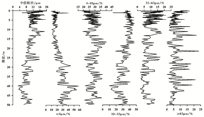
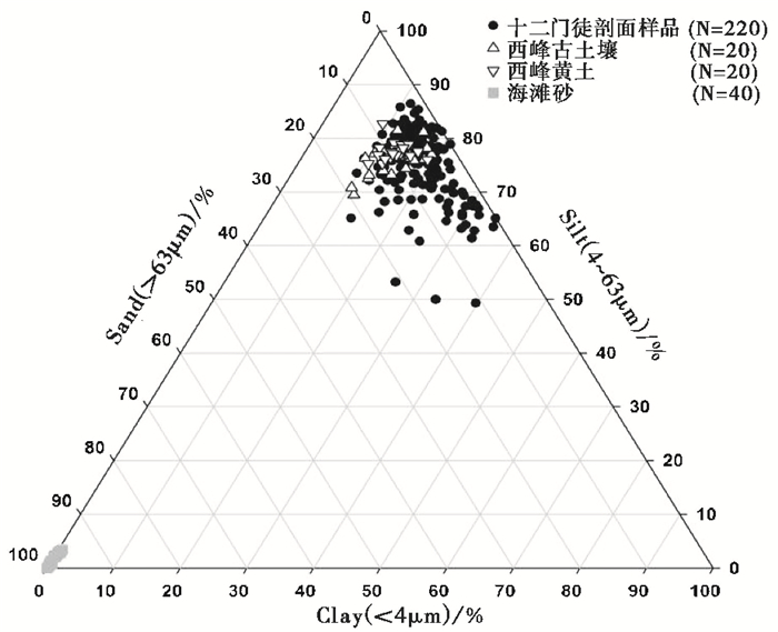
3 结果分析 3.1 粒度分析 3.1.1 粒度组成本文以4ϕ(63μm)和8ϕ(4μm)作为砂粒、粉砂和粘粒的分界线(参考国家海洋局1977年粒度分级ϕ标准[36])。对十二门徒剖面220个样品的粒度分析结果表明(图 2),在整个序列中,所有样品都以粉砂颗粒为主,中值粒径变化范围在3.014~20.702μm;>63μm粗颗粒含量最大值为23.588 %,最小值为0.118 %,平均值为6.484 %。我们将西峰黄土古土壤和秦皇岛现代海滩砂与十二门徒剖面样品粒度组成进行对比(图 3),发现十二门徒剖面样品粒度组成与西峰黄土古土壤相似,都以粉砂质颗粒为主,而海滩砂则以砂粒为主。在厚达50m的序列中,这种稳定的细粒沉积不能用除风力以外的其他动力解释,是风尘堆积的典型特征。
|
图 2 十二门徒地层剖面的粒级组成和变化 Fig. 2 Variations of median grain-size and contents of different fractions in the Twelve Apostles section |
|
图 3 十二门徒剖面样品、西峰黄土古土壤和现代海滩砂样品的粒度组分对比 Fig. 3 Clay-silt-sand triangular plots of the Twelve Apostles section, Quaternary Xifeng loess-palaeosol and modern beach sand |
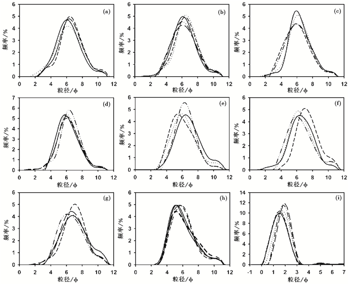
粒度频率曲线指示着各粒径颗粒在样品中的百分含量,并显示沉积物粒度分布的范围,粒级大小与搬运动力和沉积环境相关[37]。图 4中(a)~(g)为十二门徒剖面各层典型样品的粒度频率分布曲线,它们显示了该剖面自上而下的粒度特征均与西峰黄土古土壤(图 4h)一样,都呈双峰分布,大于100μm颗粒的含量少。但是与以粗颗粒(0.5~1.0mm)为主的秦皇岛现代海滩砂相比(图 4i),存在明显差别。
|
图 4 十二门徒剖面样品、西峰黄土古土壤和现代海滩砂样品粒度分布的频率曲线 (a~g)十二门徒剖面自上而下各层位的样品;(h)西峰黄土古土壤样品(实线为古土壤样品,虚线为黄土样品);(i)现代海滩砂样品 Fig. 4 Grain-size distribution curves of the Twelve Apostles section (a~g), Quaternary Xifeng loess-palaeosol (h) and modern beach sand (i) |
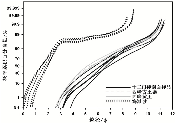
概率累积曲线可反映沉积物搬运方式和粒度分布之间的关系,能有效认识沉积物搬运机制并解释沉积环境[38~42]。在概率累积曲线上(图 5),十二门徒剖面样品和西峰黄土古土壤均为单段型,反映了物质搬运形式相对简单,以悬移组分为主。现代海滩砂则与十二门徒和西峰黄土古土壤不同,其概率累积曲线为多段式为主,其小于3ϕ颗粒的累积概率大于95 %,说明其物质搬运以跃移为主。
|
图 5 十二门徒剖面样品、西峰黄土古土壤和现代海滩砂样品的粒度概率累积曲线 Fig. 5 Grain size accumulation curves of the Twelve Apostles section, typical Quaternary Xifeng aeolian loess palaeosol and modern beach sand |
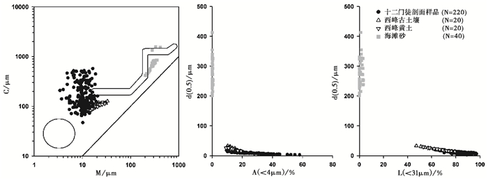
粒度象反映了沉积物粒度分布总体特征,根据粒度象可分析沉积物的形成环境;在沉积物成因的判别中,主要通过未知样品在粒度象图中的投影区域与已知成因样品投影区域的比较来确定其沉积环境[43]。从C-M、A-M和L-M图上可以清楚地看出十二门徒剖面样品的粒度象图和西峰黄土、古土壤的粒度象图很相似(图 6),与现代海滩砂有较大的区别。可能反映了十二门徒剖面样品的风成成因。
|
图 6 十二门徒剖面样品、西峰黄土古土壤和现代海滩砂样品的C-M、A-M和L-M图 C为样品累积含量为1 %时对应的粒径,A为样品粒径小于4μm的百分量,L为样品粒径小于31μm的百分量,M为样品的中值粒径 Fig. 6 The C-M, A-M and L-M plots of grain size distribution of the Twelve Apostles section, typical Quaternary Xifeng loess-palaeosol and modern beach sand |
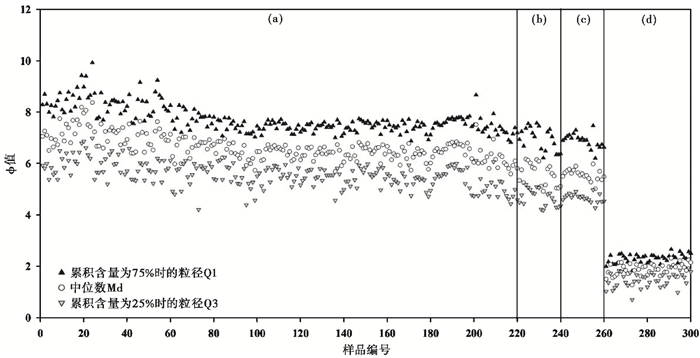
四分位值(Q1,Q3)和中位数(Md)是反映沉积物特征的重要参数,综合利用这些参数可以直接看出四分位标准差、偏度等的变化,了解沉积物形成环境,从而判别不同的沉积物类型[44]。从图 7可以看出,十二门徒剖面样品与西峰黄土古土壤的粒度指数相似,而与现代海滩砂有较大差别,这反映了十二门徒剖面的风成成因。
|
图 7 十二门徒剖面样品、西峰黄土古土壤和现代海滩砂样品的粒度指数图 (a)十二门徒剖面220个样品(220 samples of the Twelve Apostles);(b)西峰黄土(Xifeng loess);(c)西峰古土壤(Xifeng palaeosol);(d)现代海滩砂(modern beach sand) Fig. 7 Q1-Md-Q3 plots of the Twelve Apostles section, typical Quaternary Xifeng aeolian loess-palaeosol and modern beach sand |
判别分析是一种多变量统计分析方法,通过对沉积物粒度参数的综合统计分析,选取合适的粒度参数指标,以判别出不同的沉积作用和沉积环境。本文采用Sahu[45]的判别公式来计算所测量样品的判别值,公式如下:

|
(1) |
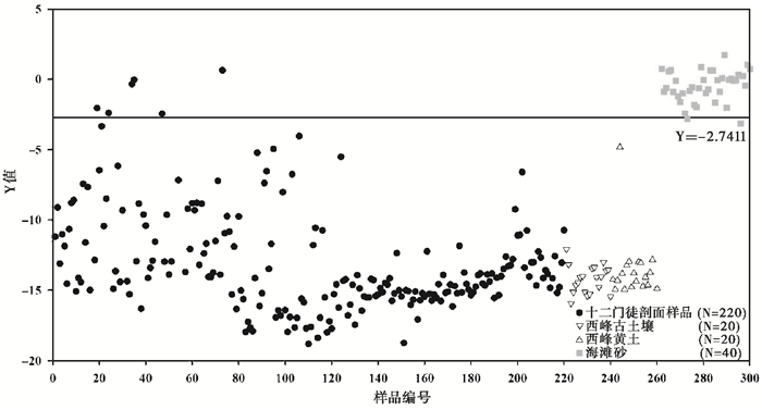
公式(1)中,Y为判别参数,Mz、σ2、SK和KG分别为平均粒径、标准偏差、偏度和峰态。该判别公式是区分风尘沉积物与海滩沉积物,根据Sahu[45]的研究,公式(1)中计算的风尘堆积的判别值应该小于-2.7411,已有部分学者[46, 47]利用该公式作为沉积物成因判断的依据;他们的研究表明,典型风成沉积物的判别值均是负值,水成沉积物大部分是正值。从图 8中可以看出,十二门徒220个样品,仅有6个样品的判别参数Y大于-2.7411,其余均小于-2.7411,西峰黄土古土壤全部小于-2.7411,现代海滩砂(40个)仅一个样品小于-2.7411,其余均大于-2.7411。这又反映了十二门徒与西峰黄土古土壤成因的一致,为风成成因,与现代海滩砂成因有明显不同。说明十二门徒地层物质的来源分为两部分:一部分为近源输送,即其物质主要来源于海滩附近,但是这一部分所占比例较少;另一部分为远源输送,这一部分占主导地位。
|
图 8 十二门徒剖面样品、西峰黄土古土壤和现代海滩砂样品的判别参数 Fig. 8 Y-values of the grain-size distributions for the Twelve Apostles section, typical Quaternary Xifeng loess-palaeosol and modern beach sand |
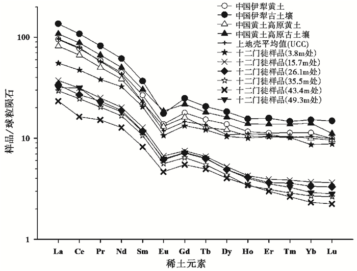
稀土元素(REE)是一类非常特殊的元素,它们的化学性质非常相似,在沉积岩风化、剥蚀、搬运、再沉积及成岩作用过程中,由于稀土元素性质的微弱差异又可以发生元素的富集与亏损,因而沉积岩中稀土元素含量的变化与物源区的成分、沉积环境密切相关[48~52]。细粒的风尘物质在源区经历了多个沉积旋回,在搬运和沉积的过程中被充分混合,从而使风尘沉积具有和上地壳相近的稀土元素分配模式[53]。将澳大利亚十二门徒地层样品与上地壳平均值(UCC)[49]、中国黄土高原黄土以及伊犁黄土的稀土元素(数据引自文献[54])进行比较,经球粒陨石归一化后,发现它们的稀土元素分配模式具有较高的相似性(图 9),即轻稀土富集,Eu中度负异常。但澳大利亚十二门徒的稀土总含量相对于中国黄土来说是亏损的(图 9),这可能与它们之间的物源、风化过程和沉积环境存在差异有关。这些结果表明它们都来自宽阔的、包含各种矿物成分的物源区,在远距离搬运过程中得到充分混合后的沉积,显示了典型风成物的特点[55]。
|
图 9 十二门徒剖面典型样品与上地壳平均值(UCC)[49]和中国不同黄土[54]稀土元素分配模式的对比 Fig. 9 Comparison of rare earth element (REE) distribution patterns between the Twelve Apostles section, UCC[49] and different loess sediments in China[54] |
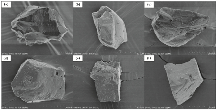
石英具有硬度大、化学性质稳定等特点,其表面经受机械作用或化学作用后留下的痕迹可以保存较长时间,沉积物中的石英颗粒表面微结构记录了其在风化、搬运、沉积过程中所经受的一系列作用,因而石英颗粒的表面形态特征也常被用于沉积环境和沉积成因类型的判别[56~58]。显微镜下观察显示(图 10),澳大利亚十二门徒剖面典型样品的石英颗粒的形状呈不规则的棱角、次棱角状且大小基本小于63μm,有的颗粒具有锋利的边缘(图 10a、10b、10e和10f)以及麻坑(图 10a、10c、10d和10e)等风成成因特征,缺少典型大陆架砂以及现代海滩砂的磨圆特征。十二门徒剖面典型样品中石英颗粒的尖棱角状表明,粉尘被风吹扬搬运至沉降区后,基本保留了风成石英颗粒的形态特征。
|
图 10 十二门徒剖面典型样品的石英颗粒表面形态 Fig. 10 Surface aeolian features of quartz grains from the Twelve Apostles section |
十二门徒海岸地层是含石灰质的粉砂沉积序列,夹有海相生物化石和碎屑,近海岸边的局部层位发育典型岩溶形态,前人据此认为该地层是一套沉积在一个中到高能的浅海大陆架环境中的海相石灰岩[27, 29~32]。我们野外考察发现该地层不仅存在海相生物碎片,同时也存在根化石、钙结核层等地表土壤特征。显然,在判别地层的沉积环境时,需要综合分析各种证据,才能够对沉积环境有更全面更深刻的理解。
4.1 古土壤特征与地层成因分析古土壤是过去地质时期的岩石或沉积物在当时的地理环境(气候、生物、地形和时间等)下,经过物理、化学、生物等成壤作用改造而形成[59]。虽然古土壤在埋藏过程中受地质作用的影响而使土壤的一些性状发生改变,使其与现代土壤有较大差异,但大部分古土壤仍然保留着一些明显有别于其他岩石的特征,主要表现为植物根迹、土壤发生层次以及土壤结构,这三方面特征也是识别古土壤的主要依据[60, 61]。
4.1.1 植物根化石古土壤中保留着一些陆生生物遗迹化石,其中植物根化石是野外辨别沉积岩石序列中古土壤的最好标志,在一定程度上,它指示了古土壤的存在[62]。因此,根化石(Rhizoliths)的出现代表了当时适合植被生长发育的成壤期,同时植物的根系因能深入粉砂层内部,相对容易保留,故多保存于风成岩中[63]。在十二门徒地层剖面的不同层位发现大量钙化树根化石以及根管石(图 11a~11c),这些根化石的形态大多为直立型,也有水平状,疏密不等、粗细不一,保留着原始根系的形态。这些原始根系的存在则表明沉积物堆积时是处于地表成土环境。

|
图 11 十二门徒地层的特点 (a,b)钙化根系,呈垂直状分布于砂层中;(c)为根管石,数量较多且都垂直分布于地层中;(d,e)钙积层;(f)地层倾斜;(g,h)地层坍塌新鲜面;(i)典型石灰岩岩溶地貌;(j)近水平地层而风化沿着水平方向变化很大,右侧为石灰岩风化,而继续向外则为砂土状风化;(k)海蚀柱 Fig. 11 The characteristics of Port Campbell Limestone. (a, b) Many travertinized roots in the strata; (c) The rhizolith exist in Port Campbell Limestone; (d, e) CaCO3 nodules were deposited underneath these beds; (f) Some beds are tilted to follow paleotopography; (g, h) The fresh rock surface after collapse; (i) Feature of karst landform; (j) The limestone is not horizontally continuous, both aeolian features and characteristic of Karst weathering are observed from this deposition; (k) Residual sea stacks |
一个完整的古土壤剖面从上而下分异形成粘化层、淀积层等土壤发育层次[61]。钙结核层是干旱、半干旱环境下在土壤碳酸盐迁移和淀积过程中形成的,是土壤淀积产物,是位于土壤粘化层之下的淀积层[60]。钙结核的发育与降雨量密切有关,如果降雨量太少,就没有足够的水将钙质溶解,难以下渗淀积,无法形成钙结核;如果降水量太多,钙质就无法在固定的粘化层淀积形成钙结核,而是继续随水下渗,钙质就会因此而流失,难以淀积富集形成钙结核。中国第四纪黄土-古土壤是风成沉积序列,就存在上述情形[64]。
在十二门徒的粉砂层风化面中普遍发育钙结核层(图 11d~11f),滴稀盐酸可以产生剧烈的气泡。需要指出的是,该地层中存在两种不同钙质淀积:一种是发育在土壤粘化层之下的钙结核层(图 11d),另外一种是披覆于陡崖岩层表层的深灰色碳酸钙涂层(图 11e)--是由于某时期降雨量多导致淋溶的碳酸钙受重力作用发生侧向迁移形成[64]。所以,在悬崖陡坡面上形成了厚度不一、分布不均的深灰色涂层(图 11d和11e),而在坍塌面上则缺失(图 11g和11h)。因此,可以根据钙结核的发育来估算古降雨量。前人的研究[64~69]表明,年降水量在400~800mm之间利于钙结核的形成,故该地层代表着半干旱地区地表成土环境。深灰色碳酸钙涂层则是在大于800mm年降雨量的条件下发生淋溶碳酸钙侧向迁移形成,代表了该地区某时期曾经历了较湿润的气候。
4.2 地貌古地形特征十二门徒的这套地层在一些层位形成了深灰色的石笋、石钟乳等岩溶地貌(图 11i),但沿着地层向两侧追踪几十米则渐变成浅黄色层状粉砂土层(图 11j和11k),说明地层原始沉积物是浅黄色的粉砂土层,典型石灰岩岩溶风化形态只是局部在深灰色钙质富集地带发育。这种深灰色碳酸钙是在地表条件下淋溶淀积形成[64, 70]。
这套地层以水平产状为主,只在现代沟谷地区发现边坡随古地形发生倾斜,而且倾斜部分地层厚度变薄(图 11f)。浅海大陆架属于沉积型地形,如果这套地层真是沉积于浅海大陆架环境,则根据重力原理分析,其边坡沉积应该是坡上沉积薄,而往坡下渐渐变厚,这与现在观察到的情况却恰好相反,表明该地层很可能不是沉积于海洋环境。地层在边坡发生倾斜,以及层厚向坡下变薄现象,这是地表侵蚀型地貌,它在中国黄土高原的黄土古土壤风积地层中普遍可见[64, 71]。结合斜披地层中发育的钙结核层(图 11d),说明该地层发育在半干旱条件下的成土环境。
4.3 沉积物来源及搬运动力分析澳大利亚十二门徒地层剖面典型样品的稀土元素分配模式与中国黄土古土壤以及上地壳特征[49]高度相似(图 9),反映了它们物源特点的相似性,表明它们都来自宽阔的、含有各种矿物成分的陆地物源区;粒度测试结果表明(图 2~5),在整个剖面序列中,中值粒径变化范围在3.014~20.702μm之间,以细粉砂为主,少有大于63μm的组分;粒度象图(C-M、L-M和A-M)显示(图 6),澳大利亚十二门徒剖面样品与中国第四纪黄土古土壤相类似;Sahu[45]成因判别分析的结果绝大部分都小于-2.7411,与中国黄土古土壤相似,显示了地层风成成因特征;此外,大多数石英颗粒与风积黄土古土壤相类似,呈现出不规则的棱角状、次棱角状,而缺少水成沉积物的磨圆特征。说明十二门徒样品颗粒为风力悬浮状态搬运。因此,稀土元素分配模式显示了沉积物均为陆源组分,且各种矿物成分高度混合,粒度和石英颗粒表面形态说明这些物质可能是由风力搬运,即十二门徒剖面地层为风成沉积。前人的研究[72, 73],表明十二门徒的这套风积地层是从16Ma开始发育,记录了16.0Ma至5.3Ma以来的风尘沉积。
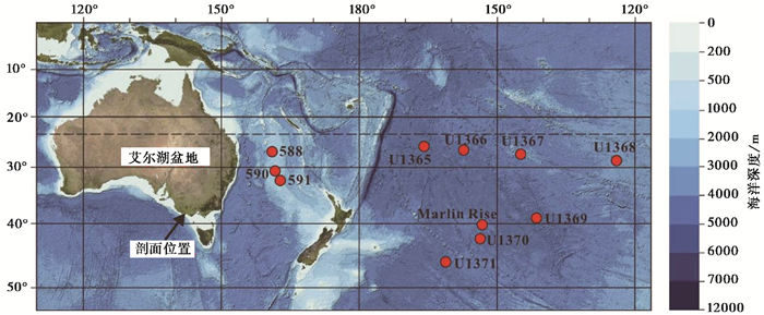
在干旱的气候条件下,植被覆盖较少、物理风化作用强烈、地表岩石极易被风化,使得风尘物质得以释放和传输[74],因此风尘沉积往往与干旱环境密切相关,风积地层序列则是过去环境变化良好的地质记录[75]。艾尔湖(Lake Eyre)流域是澳大利亚内陆干旱区,位于本研究区西北方向(图 12)。Martin[76]利用古植物学和孢粉学对澳大利亚新生代以来的气候进行恢复重建,发现在中中新世(16~12Ma)艾尔湖(Lake Eyre)流域里面的假山毛榉属(Nothofagus)锐减,冬青属(Ilex)和Austrobuxus(苦胡桃科)等物种从澳大利亚的南部和中部地区消失,表明当时该地区降水逐渐减少;Alley[77]在艾尔湖西北部的沉积物中发现,该地在中新世时期出现了碳酸盐类沉积减少而硫酸盐类沉积增多的现象,指示了该地干旱化的加剧。这些中新世中期艾尔湖流域地区干旱化的地质记录,得到了深海钻孔证据的支持;Stein和Robert[78]利用国际深海钻探计划(DSDP)第588、590和591站位的沉积物(距离澳大利亚东部海岸大约1000km左右,见图 12),依据蒙皂石与伊利石的比值推算出当时的沉积速率,发现了在14~13Ma左右粘土粉尘沉积从200g/cm2/Ma增加到500g/cm2/Ma左右,而这些粉尘物质主要来源于澳大利亚的中部和北部地区(艾尔湖流域),推测该地区在中中新世就已经开始干旱化;Dunlea等[79]首先对深海钻孔沉积物中(综合大洋钻探计划IODP第329航次的7个站位U1365~U1371,见图 12)的风尘沉积和火山灰沉积进行分离,然后结合年代数据并利用Q型因子分析和多元线性回归对地化元素进行分析,表明在15~10Ma之间,风尘沉积通量(MAR)突然增大,这些粉尘主要是来源于澳大利亚中部并由盛行西风搬运沉积于海洋中,这与该时期澳大利亚干旱化有关;Stancin等[80]利用Sr同位素定年、粒度和稀土元素对南太平洋Marlin Rise钻孔(见图 12)的风尘沉积物进行研究,揭示了该钻孔17.5Ma以来的风尘记录,稀土物源示踪表明该风积物并非来源于南极洲,而是来自澳大利亚的艾尔湖(Lake Eyre)盆地和新西兰(南岛)。
|
图 12 艾尔湖盆地、十二门徒剖面和深海钻孔位置分布图 地形底图来源于http://georezo.net/ Fig. 12 The location of the Lake Eyre basin, stratigraphic section of the Twelve Apostles and deep sea core. Bathymetric base map modified from http://georezo.net/ |
新生代板块运动驱动着澳大利亚的气候变化,古新世恰逢澳大利亚和南极洲之间的洋壳扩张的早期阶段,澳大利亚南海岸与当前南极洲的岸线处于同一纬度[81]。始新世早期,随着澳大利亚板块向北运动,“塔斯马尼亚通道”的逐步开通,澳大利亚与南极洲渐渐分离,约20~15Ma时与亚洲板块接触,导致了大规模的气候变化,包括南极冰盖的形成与发展[82]。约从14Ma开始,深海有孔虫氧同位素值由 < 1.5 ‰升高到>2 ‰,南极冰盖逐渐扩张并发育成永久性冰盖,形成新生代深海氧同位素记录的第二个明显降温时期,称为中中新世降温事件[83~85]。Shevenell等[86, 87]根据南大洋南塔斯曼海隆1170站沉积物有孔虫壳体氧同位素和Mg/Ca比值的变化,证明中新世中期南极冰盖形成时,南塔斯马尼亚隆起地区表层海水温度下降6~7℃。概括而言,由于澳大利亚大陆北移至干旱纬度(30°S)附近、南极洲与澳大利亚之间的“塔斯马尼亚通道”的开通以及气候变冷(南极冰盖的形成以及扩大)导致了澳大利亚内陆的中新世中期的气候干旱化加剧,使得该地区变成风积物发育的重要源区,盛行西风则将这些风积物搬运进入南太平洋,使得该区深海风尘沉积通量增加。
由此可见,由于澳大利亚板块向北推移,使得澳大利亚进入干旱纬度带,导致澳大利亚中新世中期艾尔湖盆地干旱化加剧,为十二门徒风积地层提供物质来源。而近地面风(偏北风)的加强则为粉尘物质提供了搬运动力。从十二门徒风积地层的粒级组成(图 2)可以看出,中值粒径自下而上有逐渐变大的趋势,小于4μm的百分比含量逐渐变小而大于63μm的百分含量却有增大,显示了艾尔湖盆地(物源区)从中新世中到中新世晚期(16.0Ma至5.3Ma)干旱化日益加剧。
4.4 海相生物化石来源可能性分析在古地理环境分析时,生物化石通常作为判别沉积环境的一个重要依据;但是埋藏化石群和其反映的沉积环境有时是不一致的,陆相生物遗骸可以被河流带入海洋,海生生物也有可能因潮汐或风暴潮等因素而被带到陆地[88, 89]。因此利用生物化石判别沉积环境时,还需要综合各种地质现象才能做出比较合理的推断。
山东庙岛黄土是典型的陆相风积黄土,但研究发现该黄土堆积中存在相当数量的海相有孔虫化石[90],刘东生等[91]将此现象解释为冰期时海平面下降,原来浅海沉积的有孔虫被风吹到陆地黄土层中保留下来。因此,海相生物化石存在,尤其是细小生物化石的出现,并不一定能够代表地层的整体沉积环境。前人[28, 30]利用电子显微镜对澳大利亚十二门徒的地层岩石进行观察,发现该套岩层中存在有孔虫化石,其大小在50~500μm之间,平均大小在100μm左右;同时在野外考察中,我们在个别近海层位发现较大的海相贝壳类化石(直径可达10cm),这说明这套地层沉积过程中确实受到海水作用。但是从整体上考虑,该套地层主体是浅黄色地层,这些海相生物化石只发现于一些近海层位,可能是由于该地层靠近海岸,会受到地质时期海平面变化的影响,以致剖面的部分层位出现海相生物化石。前已述及,该剖面以近水平状的粘化层与钙积层交互出现为主(图 11d),显示了以地表风积为主要特征的古土壤地层。但是,该地层年代为16.0~5.3Ma,期间经历多次气候冷暖波动事件,而气候的波动会导致海平面的升降变化[92],容易使地层受到风暴潮的影响,也不排除个别层位在高海平面时期短时间内处于水下环境并接受沉积,从而使某些层位出现海相生物化石。
5 结论澳大利亚东南部的十二门徒中中新世地层过去一直被认为是沉积于浅海大陆架环境中的石灰岩。我们野外考察发现:1)该地层虽然局部发育典型岩溶风化,但是总体是一套发育着许多钙结核层的古土壤序列;2)在古土壤层中发现了许多树根化石;3)近水平分布的钙结核层在现代沟谷发生斜披,厚度变薄,指示着该地层形成时期是处于地表侵蚀环境。室内详细的粒度、石英颗粒表面形态以及稀土元素特征研究表明:4)在整个剖面序列中以细粉砂为主,中值粒径变化范围在3.014~20.702μm之间,与典型中国第四纪西峰黄土古土壤具有相似的粒度分布与粒度象特征,Sahu判别分析结果绝大部分都小于-2.7411,显示了剖面整体以风积成因为主;5)十二门徒地层样品的石英颗粒呈不规则的棱角状、次棱角状,与中国西峰黄土古土壤中的石英具有相似的表面形态特征;6)稀土元素分配模式显示,十二门徒剖面样品与中国典型黄土古土壤以及上地壳(UCC)相似,具有风积特征;7)澳大利亚艾尔湖流域在中新世中期植被的大量减少,导致地表土层和岩石裸露,加之气候日趋干旱化,为十二门徒的这套风积地层提供丰富的物质来源;8)该剖面记录了16.0~5.3Ma以来的风积历史与气候变化,表明澳大利亚的干旱化至少是在16Ma前就开始了;9)由于这套风积地层靠近海岸,极易受到地质时期海平面变化的影响,以致剖面的部分层位出现海相生物化石。
致谢: 感谢福建师范大学地理科学学院蔡炳贵、姜修洋和陈秀玲三位老师在野外考察和采样时所给予的帮助;感谢中国科学院城市环境研究所郑越博士在扫描电镜实验中给予的帮助;感谢福建师范大学地理科学学院方红、孙焕宇和朱甜英三位同学在稀土元素实验中给予的帮助;感谢审稿专家和杨美芳老师对本文提出的宝贵修改建议和意见。
| 1 |
冯增昭. 碳酸盐岩沉积环境及岩相古地理的研究. 石油实验地质, 1980, 2 (3) : 24~31.
Feng Zengzhao. Study of sedimentary environment and lithofacies paleogeography of carbonate stone. Petroleum Geology & Experiment,1980, 2 (3) : 24~31. (  0) 0)
|
| 2 |
Irwin M L. General theory of epeiric clear water sedimentation. AAPG Bulletin,1965, 49 (4) : 445~459.
( 0) 0)
|
| 3 |
Laporte L F. Recognition of a transgressive carbonate sequence within an epeiric sea:Helderberg Group (Lower Devonian) of New York State. AAPG Bulletin,1969, 51 (1) : 98~119.
( 0) 0)
|
| 4 |
Wilson J L.
Carbonate Facies in Geologic History. New York: Springer-Verlag, 1975 : 1 ~471.
( 0) 0)
|
| 5 |
关士聪, 演怀玉, 丘东洲等.中国晚元古代至三叠纪海域沉积环境模式探讨.石油与天然气地质, 1980, 1(1):2~17
Guan Shichong, Yan Huaiyu, Qiu Dongzhou et al. Investigations on the marine sedimentary environmental model of China in Late-Proterozoic to Triassic periods. Oil & Gas Geology, 1(1):2~17 (  0) 0)
|
| 6 |
Erik F.
Microfacies of Carbonate Rocks:Analysis, Interpretation and Application. New York: Springer Verlag, 2004 : 10 ~21.
( 0) 0)
|
| 7 |
Pappalardo M, Chelli A, Ciampalini A, et al. Evolution of an Upper Pleistocene aeolianite in the northern Mediterranean (Liguria, NW Italy). Italian Journal of Geosciences,2013, 132 (2) : 290~303.
doi:10.3301/IJG.2012.30 ( 0) 0)
|
| 8 |
Lipar M, Webb J A. The formation of the pinnacle karst in Pleistocene aeolian calcarenites (Tamala limestone) in Southwestern Australia. Earth Science Reviews,2014, 140 (5) : 182~202.
( 0) 0)
|
| 9 |
李孝泽, 董光荣, 靳鹤龄, 等. 鄂尔多斯白垩系沙丘岩的发现. 科学通报, 1999, 44 (22) : 2102~2106.
Li Xiaoze, Dong Guangrong, Jin Heling, et al. Discovery of Ordos Cretaceous dune rock and its significance. Chinese Science Bulletin,1999, 44 (22) : 2102~2106. doi:10.1007/BF02884931 (  0) 0)
|
| 10 |
Elasmar H M. Aeolianite sedimentation along the northwestern coast of Egypt:Evidence for Middle to Late Quaternary aridity. Quaternary Science Reviews,1994, 13 (8) : 699~708.
doi:10.1016/0277-3791(94)90100-7 ( 0) 0)
|
| 11 |
Sperling C H B, Goudie A S. The miliolite of western India:A discussion of the aeolian and marine hypotheses. Sedimentary Geology,1975, 13 (1) : 71~75.
doi:10.1016/0037-0738(75)90052-4 ( 0) 0)
|
| 12 |
Vacher H L, Rowe M P.
Geology and Hydrogeology of Carbonate Islands. New York: Elsevier, 1997 : 1 ~933.
( 0) 0)
|
| 13 |
Vacher H, Hearty L, Rowe M, et al. Stratigraphy of Bermuda:Principles and application of multiple systems of classification. Special Paper of the Geological Society of America,1995, 300 : 271~294.
( 0) 0)
|
| 14 |
Erginal A E, Kiyak N G, Ekinci Y L, et al. Age, composition and paleoenvironmental significance of a Late Pleistocene eolianite from the western Black Sea coast of Turkey. Quaternary International,2013, 296 : 168~175.
doi:10.1016/j.quaint.2012.04.031 ( 0) 0)
|
| 15 |
业治铮, 张明书, 韩春瑞, 等. 西沙石岛风成石灰岩和化石土壤的发现及其意义. 海洋地质与第四纪地质, 1984, 4 (1) : 1~10.
Ye Zhizheng, Zhang Mingshu, Han Chunrui, et al. A new discovery on Shidao Island of Xisha archipelago:Eolianite (eolian calcarenite) and fossil soils. Marine Geology & Quaternary Geology,1984, 4 (1) : 1~10. (  0) 0)
|
| 16 |
赵希涛, 王绍鸿, 孙亨伦, 等. 福建莆田海岸沙丘岩的发现与鉴别. 海洋地质与第四纪地质, 1986, 6 (4) : 117~118.
Zhao Xitao, Wang Shaohong, Sun Henglun, et al. Discovery and distinguish of carbonate eolianitein Putian, Fujian. Marine Geology & Quaternary Geology,1986, 6 (4) : 117~118. (  0) 0)
|
| 17 |
刘以宣, 朱袁智, 卓家伦. 汕头广澳全新世风坡积砂丘岩的发现--兼论东南沿海全新世碳酸盐胶结碎屑岩的类型. 热带海洋, 1987, 6 (4) : 1~9.
Liu Yixuan Zhu Yuanzhi Zhuo Jialun. Discovery of Holocene aeolian-deluvium dune rock at Shantou Guang'ao--Discussion on types of Holocene calcicemented clasolite along the coast of Southeast China. Journal of Tropical Oceanography,1987, 6 (4) : 1~9. (  0) 0)
|
| 18 |
Butts C. The Loyalhanna limestone of southwestern Pennsylvania especially with regard to its age and correlation. American Journal of Science,1924, 45 (6) : 249~257.
( 0) 0)
|
| 19 |
Berg T M. Ancient eolianite (wind blown sand) in Centre County. Pennsylvania Geology,1980, 11 (6) : 13~15.
( 0) 0)
|
| 20 |
Adams R W. Loyalhanna limestone cross-bedding and provenance. In:Fisher C W, Pettijohn F J, Reed J C et al. eds. Studies of Appalachian Geology:Central and Southern. New York:Interscience Publishers, 1970. 83~100
( 0) 0)
|
| 21 |
Dodd J R, Zuppann C W, Harris C D et al. Petrologic method for distinguishing eolian and marine grainstones, Ste. Genevieve limestone (Mississippian) of Indiana. In:Keith B D, Zuppann C W eds. Mississippian Oolites and Modem Analogs. New York:American Association of Petroleum Geologists, 1993. 49~59
( 0) 0)
|
| 22 |
Ekdale A A, Picard M D. Trace fossils in a Jurassic eolianite, Entrada Sandstone, Utah, U.S.A. In:Curran H A ed. Biogenic Structures:Their Use in Interpreting Depositional Environments. New York:Society for Sedimentary Geology, 1985. 3~12
( 0) 0)
|
| 23 |
王国忠, 吕炳全. 西沙群岛石岛上沉积背斜等组构的指相意义. 同济大学学报, 1981, 10 (4) : 71~79.
Wang Guozhong, Lü Bingquan. Environmental implication of sedimentary anticlinés and other fabrics of the pleistocene biosparites on Shidao Island of the Xisha archipelago. Journal of Tongji University,1981, 10 (4) : 71~79. (  0) 0)
|
| 24 |
邹仁林, 朱袁智, 王永川, 等. 西沙群岛珊瑚礁组成成分的分析和"海藻脊"的讨论. 海洋学报, 1979, 2 (1) : 292~297.
Zou Renlin, Zhu Yuanzhi, Wang Yongchuan, et al. Analysis of biotic composition and discussion of "Algalridge" on coral reefs of the Xisha Islands, Guangdong Province, China. Acta Oceanologica Sinica,1979, 2 (1) : 292~297. (  0) 0)
|
| 25 |
业治铮, 何起祥, 张明书, 等. 西沙石岛晚更新世风成生物砂屑灰岩的沉积构造和相模式, 1985, 3 (1) : 1~15.
Ye Zhizheng, He Qixiang, Zhang Mingshu, et al. The sedimentary structures and the facies model of the Late Pleistocene eolian biocalcarenites in Shidao Island of Xisha archipelago, China. Acta Sedimentologica Sinica,1985, 3 (1) : 1~15. (  0) 0)
|
| 26 |
冯伟民, 余汶. 西沙群岛石岛晚更新世碳酸盐土壤层陆栖蜗牛化石. 海洋地质与第四纪地质, 1991, 11 (3) : 69~74.
Feng Weimin, Yu Wen. Terrestrial snail fossils in soil layers of Late Pleistocene eolian biocalcarenite in the Shidao Island of the Xisha Islands. Marine Geology & Quaternary Geology,1991, 11 (3) : 69~74. (  0) 0)
|
| 27 |
Baker G. Features of a Victorian limestone coastline. The Journal of Geology,1943, 51 (5) : 359~386.
( 0) 0)
|
| 28 |
Baker G. The relationship of cyclammina-bearing sediments to the older Tertiary deposits southeast of Princetown, Victoria. Memoirs of Museum Victoria,1953, 18 : 125~134.
( 0) 0)
|
| 29 |
Tickell S J, Abele C, Edwards J. Port Campbell Embayment 1︰100000 Map Geological Report. Victoria:Geological Survey of Victoria,1992 : 21~32.
( 0) 0)
|
| 30 |
Nicolaides S. Marine-derived dolomite in the shallowly buried temperate Port Campbell limestone (Miocene), Otway Basin, Australia. Sedimentology,1997, 44 (1) : 143~157.
doi:10.1111/sed.1997.44.issue-1 ( 0) 0)
|
| 31 |
Nicolaides S. Cementation in Oligo-Miocene non-tropical shelf limestones, Otway Basin, Australia. Sedimentary Geology,1995, 95 (1) : 97~121.
( 0) 0)
|
| 32 |
Holdgate G R, Gallagher S J. Tertiary:A period of transition to marine basin environments. In:Birch W D ed. Geology of Victoria. Melbourne:Geological Society of Australia, 2003. 289~335
( 0) 0)
|
| 33 |
Dickinson J A, Wallace M W, Holdgate G R, et al. Origin and timing of the Miocene-Pliocene unconformity in Southeast Australia. Journal of Sedimentary Research,2002, 72 (2) : 288~303.
doi:10.1306/082701720288 ( 0) 0)
|
| 34 |
鹿化煜, 安芷生. 前处理方法对黄土沉积物粒度测量影响的实验研究. 科学通报, 1997, 42 (23) : 2535~2538.
Lu Huayu, An Zhisheng. The influence of pre-treatment to grain-size analysis results of loess. Chinese Science Bulletin,1997, 42 (23) : 2535~2538. (  0) 0)
|
| 35 |
孙有斌. 黄土样中石英单矿物的分离. 岩矿测试, 2001, 20 (1) : 23~26.
Sun Youbin. Separation of quartz minerals from loess samples. Rock & Mineral Analysis,2001, 20 (1) : 23~26. (  0) 0)
|
| 36 |
国家海洋局.
海洋调查规范 . 北京: 海洋出版社, 1979 : 9 ~88.
State Oceanic Administration. Specfication of Oceanographic Investigation. Beijing: China Ocean Press, 1979 : 9 ~88. (  0) 0)
|
| 37 |
孙东怀, 安芷生, 苏瑞侠, 等. 古环境中沉积物粒度组分分离的数学方法及其应用. 自然科学进展, 2001, 11 (3) : 269~276.
Sun Donghuai, An Zhisheng, Sun Ruixia, et al. Mathematics method and its application of grain-size distribution of paleoenvironment sediments. Progress in Natural Sciences,2001, 11 (3) : 269~276. (  0) 0)
|
| 38 |
董玉祥. 国外海岸沙丘形成与演化的研究. 海洋地质与第四纪地质, 2001, 21 (2) : 93~98.
Dong Yuxiang. Research on the formation and evolution of coastal dunes in foreign countries. Marine Geology & Quaternary Geology,2001, 21 (2) : 93~98. (  0) 0)
|
| 39 |
涂路遥, 周鑫, 刘毅, 等. 近海泥质沉积物敏感粒径作为冬季风强度指标的再研究:与器测数据的对比. 第四纪研究, 2015, 35 (6) : 1393~1400.
Tu Luyao, Zhou Xin, Liu Yi, et al. Re-analysis of sensitive grain size of coastal muddy sediments as proxy of winter monsoon strength:Comparison with instrumental data. Quaternary Sciences,2015, 35 (6) : 1393~1400. (  0) 0)
|
| 40 |
刘世昊, 丰爱平, 李培英, 等. 现代黄河三角洲地区晚更新世以来高分辨率沉积粒度特征及动力沉积环境演化. 第四纪研究, 2015, 35 (2) : 291~306.
Liu Shihao, Feng Aiping, Li Peiying, et al. High-resolution grain size distribution and evolution of the sediment-dynamic environment in the modern Yellow River delta since the Latest Pleistocene. Quaternary Sciences,2015, 35 (2) : 291~306. (  0) 0)
|
| 41 |
姜韬, 曾志刚, 南青云, 等. 全新世以来冲绳海槽北部S9孔粒度变化特征及其古气候响应. 第四纪研究, 2015, 35 (2) : 307~318.
Jiang Tao, Zeng Zhigang, Nan Qingyun, et al. The grain size characteristics of the core S9 sediments in the northern Okinawa Trough and their paleoclimate response since Holocene. Quaternary Sciences,2015, 35 (2) : 307~318. (  0) 0)
|
| 42 |
郭超, 马玉贞, 刘杰瑞, 等. 过去2000年来西藏羊卓雍错沉积物粒度记录的气候变化. 第四纪研究, 2016, 36 (2) : 405~419.
Guo Chao, Ma Yuzhen, Liu Jierui, et al. Climatic change recorded by grain-size in the past about 2000 years from Yamzhog Yumco Lake, Tibet. Quaternary Sciences,2016, 36 (2) : 405~419. (  0) 0)
|
| 43 |
Passega R. Grain size representation by CM patterns as a geologic tool. Journal of Sedimentary Research,1964, 34 (4) : 830~847.
doi:10.1306/74D711A4-2B21-11D7-8648000102C1865D ( 0) 0)
|
| 44 |
Doeglas D J. Grain-size indicates, classification and environment. Sedimentology,1968, 10 (2) : 83~100.
doi:10.1111/sed.1968.10.issue-2 ( 0) 0)
|
| 45 |
Sahu B K. Depositional mechanisms from the size analysis of clastic sediments. Journal of Sedimentary Research,1964, 34 (1) : 337~343.
( 0) 0)
|
| 46 |
乔彦松, 郭正堂, 郝青振, 等. 中新世黄土-古土壤序列的粒度特征及其对成因的指示意义. 中国科学(D辑), 2006, 36 (7) : 646~653.
Qiao Yansong, Guo Zhengtang, Hao Qingzhen, et al. Grain-size features of the Miocene loess soil sequence at Qin'an:Implications on its origin. Science in China (Series D),2006, 36 (7) : 646~653. (  0) 0)
|
| 47 |
鹿化煜, 安芷生. 黄土高原红粘土与黄土古土壤粒度特征对比--红粘土风成成因的新证据. 沉积学报, 1999, 17 (2) : 226~232.
Lu Huayu, An Zhisheng. Comparison of grain-size distribution of red clay and loess-palaeosol deposits in Chinese Loess Plateau,1999, 17 (2) : 226~232. (  0) 0)
|
| 48 |
张虎才.
元素表生地球化学特征及理论基础 . 兰州: 兰州大学出版社, 1997 : 118 ~183.
Zhang Hucai. Superficial Elemental Geochemistry and Theoretical Principles. Lanzhou: Lanzhou University Press, 1997 : 118 ~183. (  0) 0)
|
| 49 |
McLennan S M. Rare earth elements in sedimentary rocks:Influence of provenance and sedimentary processes. Reviews in Mineralogy and Geochemistry,1989, 21 (1) : 169~200.
( 0) 0)
|
| 50 |
李楠, 郝青振, 张绪教, 等. 东秦岭黄土物源的常量元素和微量元素地球化学证据. 第四纪研究, 2016, 36 (2) : 332~346.
Li Nan, Hao Qingzhen, Zhang Xujiao, et al. Geochemicl evidence for the provenance of loess deposits in the eastern Qinling Mountains, Central China. Quaternary Sciences,2016, 36 (2) : 332~346. (  0) 0)
|
| 51 |
陈秀玲, 李志忠, 贾丽敏, 等. 新疆伊犁河谷沙漠沉积的稀土元素特征及其环境意义. 第四纪研究, 2013, 33 (2) : 368~375.
Chen Xiuling, Li Zhizhong, Jia Limin, et al. Rare earth element characteristics of desert sediments in Ili valley and their environmental implication. Quaternary Sciences,2013, 33 (2) : 368~375. (  0) 0)
|
| 52 |
侯顺民, 刘秀铭, 吕镔, 等. 土耳其Nallihan黄土-古土壤岩石磁学特征及其环境意义. 第四纪研究, 2015, 35 (4) : 1006~1019.
Hou Shunmin, Liu Xiuming, Lü Bin, et al. Rock magnetic properties of loess in Nallihan, Turkey and its environmental significances. Quaternary Sciences,2015, 35 (4) : 1006~1019. (  0) 0)
|
| 53 |
乔彦松, 赵志中, 李增悦, 等. 成都平原红土堆积的风成成因证据. 第四纪研究, 2007, 27 (2) : 286~294.
Qiao Yansong, Zhao Zhizhong, Li Zengyue, et al. Aeolian origin of the red earth formation in the Chengdu Plain. Quaternary Sciences,2007, 27 (2) : 286~294. (  0) 0)
|
| 54 |
叶玮.
新疆西风区黄土沉积特征与古气候 . 北京: 海洋出版社, 2001 : 1 ~175.
Ye Wei. The Loess Deposition Features and Paleoclimate in Westerly Region of Xinjiang. Beijing: China Ocean Press, 2001 : 1 ~175. (  0) 0)
|
| 55 |
梁美艳, 郭正堂, 顾兆炎. 中新世风尘堆积的地球化学特征及其与上新世和第四纪风尘堆积的比较. 第四纪研究, 2006, 26 (4) : 657~664.
Liang Meiyan, Guo Zhengtang, Gu Zhaoyan. Geochemical characteristics of the Miocene eolian deposits and comparison with the Pliocene and Quaternary eolian deposits. Quaternary Sciences,2006, 26 (4) : 657~664. (  0) 0)
|
| 56 |
陈丽华, 缪昕, 于众.
扫描电镜在地质上的应用 . 北京: 科学出版社, 1986 : 1 ~172.
Chen Lihua, Miao Xin, Yu Zhong. The Application of SEM in Geology. Beijing: Science Press, 1986 : 1 ~172. (  0) 0)
|
| 57 |
邱维理, 李容全, 朱楠, 等. 河北省丰宁地区全新世风沙活动及其对古文化的影响. 第四纪研究, 2005, 25 (6) : 729~740.
Qiu Weili, Li Rongquan, Zhu Nan, et al. Aeolian sand activities at Fengning, Hebei Province during Holocene and their influence on ancient culture. Quaternary Sciences,2005, 25 (6) : 729~740. (  0) 0)
|
| 58 |
刘进峰, 郭正堂, 乔彦松, 等. 秦安中新世黄土-古土壤序列石英颗粒形态特征、粒度分布及其对成因的指示意义. 科学通报, 2006, 51 (1) : 117~120.
Liu Jinfeng, Guo Zhengtang, Qiao Yansong, et al. Eolian origin of the Miocene loess-soil sequence at Qin'an, China:Evidence of quartz morphology and quartz grain-size. Chinese Science Bulletin,2006, 51 (1) : 117~120. doi:10.1007/s11434-005-0811-8 (  0) 0)
|
| 59 |
Wright V P.
Paleosols:Their Recognition and Interpretation. Oxford: Blackwell Scientific Publications, 1986 : 1 ~315.
( 0) 0)
|
| 60 |
Nettleton W D, Olson C G, Wysocki D A. Paleosol classification:Problems and solutions. Catena,2000, 41 (3) : 61~92.
( 0) 0)
|
| 61 |
Retallack G J.
Soils of the Past:An Introduction to Paleopedology (Second Edition). Oxford: Blackwell Scientific Publications, 2001 : 1 ~395.
( 0) 0)
|
| 62 |
Retallack G J. Paleosols. In:Winfried Henke, Ian Tattersall eds. Handbook of Paleoanthropology (Second Edition):Principles, Methods and Approaches. Berlin:Springer, 2014. 511~535
( 0) 0)
|
| 63 |
Loope D B. Rhizoliths in ancient eolianites. Sedimentary Geology,1988, 56 : 301~314.
doi:10.1016/0037-0738(88)90058-9 ( 0) 0)
|
| 64 |
刘秀铭, 吕镔, 毛学刚, 等. 风积地层中铁矿物随环境变化及其启示. 第四纪研究, 2014, 34 (3) : 443~457.
Liu Xiuming, Lü Bin, Mao Xuegang, et al. Iron minerals of aeolian deposits vary with environment and its significances. Quaternary Sciences,2014, 34 (3) : 443~457. (  0) 0)
|
| 65 |
赵景波.
淀积理论与黄土高原环境演变 . 北京: 科学出版社, 2002 : 1 ~224.
Zhao Jingbo. Deposition Theory and Evolvement of Loess Plateau Environment. Beijing: Science Press, 2002 : 1 ~224. (  0) 0)
|
| 66 |
Retallack G J. Pedogenic carbonate proxies for amount and seasonality of precipitation in paleosols. Geology,2005, 33 (4) : 333~336.
doi:10.1130/G21263.1 ( 0) 0)
|
| 67 |
李春园, 王先彬, 文启彬, 等. 黄土沉积物中碳酸盐的碳、氧同位素组成特征与古气候. 中国科学(B辑), 1995, 38 (8) : 979~986.
Li Chunyuan, Wang Xianbin, Wen Qibin, et al. The relationship between carbon and oxygen isotopic composition characteristics of carbonates in loess sediments and paleoclimate. Science in China (Series B),1995, 38 (8) : 979~986. (  0) 0)
|
| 68 |
Retallack G J, McDowell P. Paleoenvironmental interpretation of paleosols. Geology,1988, 16 (4) : 375~376.
doi:10.1130/0091-7613(1988)016<0375:PIOP>2.3.CO;2 ( 0) 0)
|
| 69 |
温昌辉, 刘秀铭, 吕镔, 等. 江西石城盆地白垩纪地层中成壤特征及古环境分析. 第四纪研究, 2016, 36 (6) : 1418~1431.
Wen Changhui, Liu Xiuming, Lü Bin, et al. The Cretaceous redbeds in Shicheng Basin, Jiangxi Province:Pedogenic and paleoenvironmental characteristics. Quaternary Sciences,2016, 36 (6) : 1418~1431. (  0) 0)
|
| 70 |
陈静生. 我国北部土壤和第四纪沉积物中化学淀积物的形成和地理分布规律. 地理学报, 1980, 35 (1) : 24~32.
Chen Jingsheng. Formation and distribution of chemical precipitates in soils and Quaternary sediments in Northern China. Acta Geographica Sinica,1980, 35 (1) : 24~32. (  0) 0)
|
| 71 |
刘秀铭, 郭晖, 刘植, 等. 甘肃临夏盆地红色地层磁组构特征与沉积环境分析. 第四纪研究, 2012, 32 (4) : 615~625.
Liu Xiuming, Guo Hui, Liu Zhi, et al. Magnetic anisotropy of red stratum in Linxia Basin and its environment of sedimentation. Quaternary Sciences,2012, 32 (4) : 615~625. (  0) 0)
|
| 72 |
Idnurm M. Late Mesozoic and Cenozoic palaeomagnetism of Australia:A redetermined apparent polar wander path. Geophysical Journal International,1985, 83 (2) : 399~418.
doi:10.1111/gji.1985.83.issue-2 ( 0) 0)
|
| 73 |
Mallett C W.
Studies in Victorian Tertiary Foraminifera:Neogene Planktonic Faunas. Melbourne: The Doctor Dissertation of the University of Melbourne, 1977 : 1 ~381.
( 0) 0)
|
| 74 |
Zhang X Y, Gong S L, Zhao T L, et al. Sources of Asian dust and role of climate change versus desertification in Asian dust emission. Geophysical Research Letters,2003, 30 (24) : 2272~2275.
( 0) 0)
|
| 75 |
鹿化煜, 王先彦, 李郎平. 晚新生代亚洲干旱气候发展与全球变冷联系的风尘沉积证据. 第四纪研究, 2008, 28 (5) : 949~956.
Lu Huayu, Wang Xianyan, Li Langping. Aeolian dust records indicate the link age of globalcooling and Asian drying in Late Cenozoic. Quaternary Sciences,2008, 28 (5) : 949~956. (  0) 0)
|
| 76 |
Martin H A. Cenozoic climatic change and the development of the arid vegetation in Australia. Journal of Arid Environments,2006, 66 (3) : 533~563.
doi:10.1016/j.jaridenv.2006.01.009 ( 0) 0)
|
| 77 |
Alley N F. Cenozoic stratigraphy, palaeoenvironment and geological evolution of the Lake Eyre basin. Palaeogeography, Palaeoclimatology, Palaeoecology,1998, 144 (3) : 239~263.
( 0) 0)
|
| 78 |
Stein R, Robert C. Siliciclastic sediments at sites 588, 590, and 591:Neogene and Paleogene evolution in the Southwest Pacific and Australian climate. Initial Reports of the Deep Sea Drilling Project,1985, 90 : 1437~1455.
( 0) 0)
|
| 79 |
Dunlea A G, Murray R W, Sauvage J, et al. Dust, volcanic ash, and the evolution of the South Pacific Gyre through the Cenozoic. Paleoceanography,2015, 30 (8) : 1078~1099.
doi:10.1002/2015PA002829 ( 0) 0)
|
| 80 |
Stancin A M, Gleason J D, Hovan S A, et al. Miocene to recent eolian dust record from the Southwest Pacific Ocean at 40 S latitude. Palaeogeography, Palaeoclimatology, Palaeoecology,2008, 261 (3) : 218~233.
( 0) 0)
|
| 81 |
Dexel J F, Preiss W V.
The Geology of South Australia (Vol.2):The Phanerozoic. South Australia: Geological Survey of South Australia, 1993 : 167 ~184.
( 0) 0)
|
| 82 |
DodsonJ R, RamrathA. 澳大利亚的第三纪及第三纪-第四纪过渡期. 第四纪研究, 2000, 20 (5) : 397~408.
Dodson J R, Ramrath A. Ramrath A. The Tertiary and Tertiary-Quaternary transition in Australian. Quaternary Sciences,2000, 20 (5) : 397~408. (  0) 0)
|
| 83 |
Zachos J, Pagani M, Sloan L, et al. Trends, rhythms, and aberrations in global climate 65Ma to present. Science,2001, 292 (5517) : 686~693.
doi:10.1126/science.1059412 ( 0) 0)
|
| 84 |
马小林, 田军. 15Ma以来海陆记录的轨道-构造尺度东亚季风的演化以及西北内陆的干旱化. 第四纪研究, 2015, 35 (6) : 1320~1330.
Ma Xiaolin, Tian Jun. East Asian monsoon evolution and aridification of Northwest China viewed from land and sea on the tectonic-orbital time scale since 15Ma. Quaternary Sciences,2015, 35 (6) : 1320~1330. (  0) 0)
|
| 85 |
应红, 宋春晖, 鲍晶, 等. 柴达木盆地东北缘中中新世以来古气候变化. 第四纪研究, 2016, 36 (4) : 847~858.
Ying Hong, Song Chunhui, Bao Jing, et al. Paleoclimate change since the Middle Miocene in the northeastern Qaidam Basin. Quaternary Sciences,2016, 36 (4) : 847~858. (  0) 0)
|
| 86 |
Shevenell A E, Kennett J P, Lea D W. Middle Miocene southern ocean cooling and Antarctic cryosphere expansion. Science,2004, 305 (5691) : 1766~1770.
doi:10.1126/science.1100061 ( 0) 0)
|
| 87 |
Shevenell A E, Kennett J P, Lea D W. Middle Miocene ice sheet dynamics, deep-sea temperatures, and carbon cycling:A Southern Ocean perspective. Geochemistry, Geophysics, Geosystems,2008, 9 (2) : 1256~1256.
( 0) 0)
|
| 88 |
同济大学海洋地质系编.
海陆相地层辨认标志 . 北京: 科学出版社, 1980 : 1 ~230.
The Department of Marine Geology in Tongji University. The Distinguishing Symbol of Marine and Terrestrial Facies. Beijing: Science Press, 1980 : 1 ~230. (  0) 0)
|
| 89 |
Johnson D.
The Geology of Australia. Cambridge: Cambridge University Press, 2009 : 173 ~175.
( 0) 0)
|
| 90 |
李文勤, 赵全基. 庙岛群岛第四系松散堆积物初步研究. 海洋科学, 1981, 5 (3) : 20~22.
Li Wenqin, Zhao Quanji. Preliminary study on the accumulation of Miaodao Islands in Quaternary. Marine Science,1981, 5 (3) : 20~22. (  0) 0)
|
| 91 |
刘东生, 等.
黃土与环境 . 北京: 科学出版社, 1985 : 191 ~277.
Liu Tungsheng, et al. Loess and Environment. Beijing: Science Press, 1985 : 191 ~277. (  0) 0)
|
| 92 |
Miller K G, Kominz M A, Browning J V, et al. The Phanerozoic record of global sea-level change. Science,2005, 310 (5752) : 1293~1298.
doi:10.1126/science.1116412 ( 0) 0)
|
② Institute of Geography, Fujian Normal University, Fuzhou 350007;
③ Department of Environmental Sciences, Macquarie University, Sydney NSW 2109, Australia)
Abstract
The Twelve Apostles as a well known landmark, were 12 residual sea stacks, located in the Port Campbell National Park, south coast of Victoria, Australia. The stratum of these sea stacks and surrounding coastal cliffs are generally believed to be marine limestone deposited continental shelf since the Tertiary Period. They indeed show weathering characteristics of karst, such as stalactite, stalagmite and clint in some locations. However, such karst features are found to be formed during secondary weathering, as they are hardly to be followed along their bedding. Furthermore, aeolian pedogenic features are observed from this deposition, such as:(1) Many CaCO3 nodules were deposited underneath these beds; (2) Plant root fossils are commonly found in such beds; (3) Some beds are tilted to follow paleotopography, indicating their original topsoil position. In order to understand the origin of Port Campbell Limestone, one section from the Twelve Apostles (143°05'21"E, 38°39'57"S) was selected to study. The thickness of the section is 50m and 220 samples were totally collected from the top to 50m of the section, sampling intervals are 10cm in upper section (from 0m to 8m) and 30cm in lower section (from 8m to 50m). Particle size, morphology of quartz grains, Rare Earth Elements (REE) were measured and compared with those of typical Quaternary aeolian loess-palaeosols and modern beach sand. The particles size of the whole section shows uniform fine feature and smaller than 100 μm. Silt fractions of Port Campbell Limestone are constantly dominant with the median grain size varying from 3.014 μm to 20.702 μm. Its particle characteristics of Port Campbell Limestone differs from those of modern beach sand, however are very close to those of loess and palaeosols according to Sahu's empirical judgement equation (the Y-values of eolian deposits using the equation should be smaller than -2.7411). Scanning Electron Microscopy (SEM) analysis demonstrations that most of the quartz grains from Port Campbell Limestone have irregular and angular shapes and many are characterized by sharp edges and conchiform fractures. These morphology features of quartz grain are considered as wind-blown characteristic. The REE patterns of Port Campbell Limestone show extreme homogeneity with those of Chinese loess-paleosol in Xifeng. These samples enriched LREE and fairly flat HREE profiles, are also the REE properties of the upper continental crust (UCC). These results indicate that the sediments of Port Campbell Limestone were all derived from well-mixed sedimentary protoliths, as are characteristic of eolian deposits. Together with features of pedogenic CaCO3 nodules and plant root fossils, the Port Campbell Limestone is rather similar in some of its properties to the Quaternary loess-palaeosols. We thus suspect the Port Campbell Limestone was unlikely deposited under an environment of continental shelf, but developed in continent as topsoil environment mainly. Previous studies revealed that climatic condition surround Lake Eyre basin had a clear change from Middle Miocene to Late Miocene, marked by deposition cessation of carbonaceous sediments and decreasing proportion of Nothofagus pollen. Aridification in Lake Eyre basin during this period may provide an aeolian source to deposit silt dust in Port Campbell and down wind area. Since Miocene, climate change between warm and cool has occurred many times, leading sea-level changes. This could be one of the reasons to interpret the aeolian sediment and pedogenic developed by coast also containing shells and well-preserved shallow or open-marine microfauna in some strata positions. 2017, Vol.37

