全新世是人类文明形成与发展的时期,是与人类密切相关的一个时期[1],理解这个时期的气候变化过程及机制是预估未来气候变化的重要基础[2],对于减轻气候变化对人类的危害具有深远意义。
内蒙古中东部地区处于亚洲季风与西风的过渡地带[3],能够很好地记录地质历史时期的气候变化。近十几年,国内外学者对内蒙古地区全新世的气候变迁做了大量的研究[4~11],随着研究的深入,对于内蒙古地区全新世季风降雨的变化提出了不同的观点:一种观点认为,中全新世时期季风降雨明显增强,气候湿润[10, 12];而另外一种观点则认为,中全新世时期季风降雨强度降低,气候干旱[13]。因此,这种区域内气候记录的不一致性还需要进一步的研究。另外,20世纪90年代末期,全新世期间北大西洋冷事件的发现[14, 15],表明全新世气候的不稳定性,这种气候的不稳定性在亚洲季风区相继被发现[16, 17],但在内蒙古地区研究较少[18]。
因此,本研究将以内蒙古中东部的查干淖尔湖为研究对象,通过AMS 14C测年、粒度及其端元组分分析、烧失量等指标的分析,重建内蒙古中东部地区7000年以来的气候环境演化序列,揭示中全新世以来的气候变化以及百年尺度的气候不稳定事件,并探讨中全新世以来千-百年尺度气候变化的驱动机制。
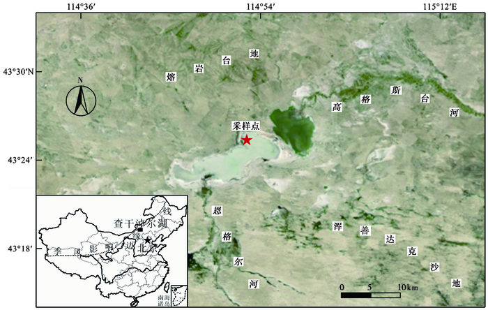
2 研究区概况查干淖尔湖(43°22′~43°29′N,114°46′~115°3′E)位于内蒙古阿巴嘎旗南部约60km处,南部为浑善达克沙地,北部为阿巴嘎熔岩台地(图 1),处于中温带半湿润-半干旱区过渡带。20世纪50年代以前湖泊为一个整体,现在已经分为东西两个湖,中间有沙岛隔开,现已修建水坝,其中西湖在2008年左右干涸。湖泊主要靠高格斯台河和恩格尔河水源补给,湖水无出口,是一个典型的高原封闭型湖泊,流域面积14000km2,流域以放牧为主,无灌溉农业。内蒙古阿巴嘎旗气象站1955~2010年观测数据显示,此区域多年平均气温1.3℃,气温年较差达42.3℃;多年平均降雨量280mm,年变率达25.9 %,降水主要集中在6月、7月和8月份(占全年降水量的69.4 %);多年平均蒸发量为1977.2mm,是降水量的7.1倍[19]。湖区气候属于中温带大陆性气候,气候特点为冬季寒冷漫长、降水量少,夏季温凉短促、降水量丰富[20]。
|
图 1 查干淖尔湖及剖面位置图 Fig. 1 Location of the Chagan-Nuur and the profile |
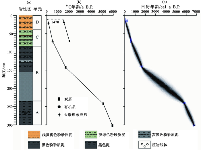
2015年7月,我们在查干淖尔湖西湖东北角(43°25′49″N,114°57′26″E;海拔1008m;图 1)以人工挖剖面的方法进行采样,采样间隔为1cm,采样深度为3m,共采得300个样品。现场对剖面进行拍照并进行了详细的岩性描述,根据岩性特征的变化,可将剖面自下而上分为4个沉积单元(图 2a):A,300~235cm,主要由黑色泥构成,在深度265cm左右发现植物残体;B,235~85cm,主要由黑色和灰黑色粉砂质泥构成;C,85~40cm,主要由灰绿色局部夹黄褐色的粉砂质泥构成;D,40~0cm,主要由浅黄褐色粉砂质泥构成。
|
图 2 查干淖尔湖剖面深度、岩性(a)及年代(b,c) Fig. 2 Lithology(a) and depth-age model(b, c) of the Chagan-Nuur profile |
在剖面的140cm、240cm、298cm处进行了炭屑的提取,炭屑样品的提取按照盐酸分散法[21],首先样品中加入过量的10 %盐酸(HCl)以除去碳酸盐,待充分反应后放入离心机离心,去上清液,加蒸馏水继续离心分离,直至变为中性溶液。最后用125μm网筛过筛处理,放入培养皿中并在显微镜下挑出足量炭屑。显微镜下观察表明挑出的炭屑为草本植物茎叶未完全燃烧后形成的。
剖面的上部未能挑出炭屑,因此在14cm和70cm处采用全有机质样品进行测年。3个炭屑样品和2个全有机质样品,送至美国Beta实验室进行AMS 14C年代的测试(表 1)。
| 表 1 查干淖尔湖剖面AMS 14C测年结果 Table 1 Results of AMS 14C dating in the Chagan-Nuur profile |
以2cm的间隔取样进行烧失量的分析测试。实验步骤如下[22]:1)将样品研磨后放入105℃电热干燥箱中烘干至恒重,称量干样品质量;2)使样品在550℃下燃烧4小时以除去样品中的有机质,冷却后称量残渣质量,计算得到LOI550:LOI 550/ % =(M105-M550)/M105,其中,LOI550是550℃时烧失量的百分比,M105是干样品质量,M550是550℃加热后残渣的质量。
3.4 粒度分析以2cm的间隔取样进行粒度分析。方法如下[23]:1)取样品约0.5g放入烧杯中,加入足量浓度为10 %的H2O2溶液用以除去有机质,将烧杯放入水浴锅中95℃加热,直至样品不再反应为止;2)加入过量蒸馏水将样品洗至中性;3)加入足量浓度为10 %的HCl溶液用以除去碳酸盐胶结,将烧杯放入水浴锅95℃加热,直至样品不再反应为止;4)加入足量蒸馏水将样品洗至中性。测试之前,加入10ml浓度为0.05M的六偏磷酸钠((NaPO3)6)溶液作为分散剂增强沉积物颗粒的分散效果,并放入超声振荡机超声震荡10分钟后用马尔文3000型激光粒度仪进行粒度测定,其测量范围为0.02~3000μm。端元组分模型可以将测量得到的粒度分布转换成一系列最适宜的端元组分的百分含量[24~26]。我们利用端元组分分析对查干淖尔湖的150个样品的粒度分布进行了计算,以分离出不同的端元。
4 结果与讨论 4.1 年代序列从表 1可以看出,利用总有机质测得的14C年龄明显偏老,这种偏老的现象在干旱半干旱区湖泊中是一种常见现象,与碳库效应有关[27]。假设上部70cm沉积速率不变,根据上部的两个的以有机质作为测年材料得到14C年龄推算,近表层的14C年龄为1470a B.P.,比实际年龄(0a B.P.)老1470年,因此利用总有机质测得的14C年龄应该减去1470年。炭屑为陆源植物燃烧剩余的残体,陆生植物直接利用大气中的CO2合成自身有机质,因此其14C测年一般不受碳库效应的影响[28, 29]。总有机质14C年龄扣除1470年后,基本上落在了炭屑年龄的延长线上(图 2b)。将扣除碳库效应的年代和炭屑的年代利用Bacon模型[30],计算获得每一深度随日历年龄变化的曲线(图 2c)。计算表明,300cm深的查干淖尔湖剖面时间跨度约为0~6900cal.a B.P.。
4.2 代用指标的指示意义 4.2.1 烧失量LOI550烧失量是一种广泛使用的估测沉积物中有机质和碳酸盐含量的方法[31]。将样品在550℃下持续加热得到烧失量LOI550的数值代表样品中有机质的百分含量[32]。前人研究表明,烧失量与有机质含量之间存在很好的对应关系[33]。因此,烧失量间接地反映湖泊初级生产力及湖泊周围植被覆盖度[34~36]。
湖泊沉积物中有机质含量是重建湖泊古气候环境演变过程的重要指标之一[31, 37]。有机质含量较高则说明湖泊初级生产力或流域内生物生产量高[38~40]。大量研究表明[36, 40~45],寒冷干燥的气候条件下,生物生长受到抑制,使得湖泊初级生产力下降,陆源有机质输入量减少,同时干燥环境使得湖泊水位下降,湖水盐化,湖泊水位下降也会使湖水中CO2含量增加,导致pH值降低[46],这些因素都会加速有机质分解,从而导致沉积物中有机质含量减少;温暖湿润条件下,不仅使得湖泊初级生产力和陆源有机质输入量增加,湖水淡化、水位升高也有利于有机质保存,导致有机质含量增高。因此,低的烧失量LOI550指示气候冷干,高的烧失量LOI550指示气候相对暖湿。
4.2.2 粒度湖泊沉积物中的粒度特征对于解释湖泊水动力条件、地形地貌和沉积环境具有特殊的意义,并且在古气候和古环境演变中应用广泛[11, 47, 48]。前人的研究成果表明,一方面,湿润气候条件下,湖泊面积增加,水位相应升高,沉积物搬运距离增加,更多细粒物质在沉积中心沉积下来,导致沉积物总体粒径下降[49, 50];另一方面,河流的搬运能力增强,从而携带更多的粗颗粒物质,致使沉积物总体粒径增高[51, 52]。由图 1可知,查干淖尔湖湖泊面积较大且采样点位置距离河流入湖口远,因此推断湖泊沉积物大小主要受湖泊水动力条件的影响。另外,在干旱-半干旱地区,干旱的气候条件以及风成作用的加强,能够携带更多的粗颗粒物质入湖,同样能够使得沉积物的总体粒径增高[12, 53]。
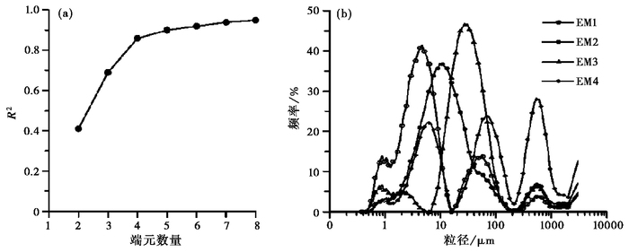
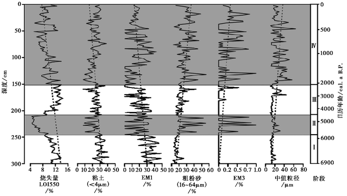
单一沉积或搬运过程形成的沉积物的粒度分布的频率曲线呈现单峰特征,沉积物粒度分布的频率曲线呈现多峰分布就说明不止一种沉积或搬运过程[47, 54, 55]。将多峰分布的沉积物通过数学模型计算得到不同沉积组分的数值,再基于端元组分分析就可以分辨出不同的搬运沉积过程[24, 25]。根据Weltje[24]的端元组分分析模型,复相关系数(R2)代表测量得到的粒度分布数据被端元分析模型拟合的程度。当端元数为4时,拟合程度为84 % (图 3a),可以大致反映沉积物粒度分布的波动情况,根据端元组分数量应尽量少、拟合程度高的原则选取端元数为4[24]。对查干淖尔湖剖面粒度的端元组分分析表明:4个端元EM1、EM2、EM3和EM4在所有样品中的百分比分别为41.8 %、40.2 %、14.0 %和4.0 %,其中EM1、EM2和EM3的主峰值分别位于4μm、10μm和30μm左右,而EM4有3个明显的峰,分别位于6μm、70μm和600μm左右(图 3b)。通常认为EM1由流水搬运入湖的较细的部分[54, 55, 56],EM1变化与细粒的粘土组分变化具有较好的一致性(图 4),因此,可以利用EM1和粘土组分反映入湖水量的变化,EM1和粘土组分增高,表明流水搬运入湖的细颗粒组分增高,气候湿润,反之干旱。而EM3通常被认为代表由风力搬运而来的较粗的部分[54, 56],EM3变化与粗粒砂的组分变化具有较好的一致性(图 4),因此,EM3和粗粉砂组分增高,表示风力作用加强,气候相对较干,反之较湿。EM4是由岸边形成的浮冰携带或突发暴雨形成的[56],由于该组分所占的比例较低(平均4 %),这里不再讨论它的气候指示意义。
|
图 3 查干淖尔湖剖面粒度的端元组分 (a)端元2~8EM的决定系数(R2);(b)端元组分的粒度分布特征 Fig. 3 End-member modeling results for the grain-size of Chagan-Nuur profile. (a)Coefficient of determination(R2) of all size classes for each end-member model; (b)The characteristics of grain-size distribution for the modeled end members |
|
图 4 查干淖尔湖剖面LOI550、粘土、EM1、粗粉砂、EM3及中值粒径变化 Fig. 4 LOI550, clay, EM1, coarse silt, EM3 and median size variations versus depth for the profile of Chagan-Nuur |
从图 4中可以看出,烧失量LOI550、粘土、EM1百分含量呈降低趋势,而粗粉砂、EM3百分含量及中值粒径呈升高趋势,表明6900年以来流域气候逐渐变干。根据查干淖尔湖剖面的各项指标的波动情况,可以将流域气候变化过程划分为以下4个阶段(图 4):
阶段Ⅰ (300~244cm;6900~5800cal.a B.P.):烧失量LOI550、粘土、EM1较高,平均值分别为10.8 %、31.0 %和67.9 %;粗粉砂及中值粒径平均值较低,分别为16 %、14μm,EM3百分含量为零,表明此阶段气候湿润。
阶段Ⅱ (244~212cm;5800~4500cal.a B.P.):烧失量LOI550、粘土、EM1明显降低,分别为6.1 %、20.0 %和36.0 %;粗粉砂和中值粒径增加至27 %和28.5μm,并且出现EM3,平均百分含量为16.9 %,表明此阶段流域气候干旱。
阶段Ⅲ (212~151cm;4500~2000cal.a B.P.):烧失量LOI550平均值增高至12.8 %,粘土和EM1变化不大,但含量有所增加;粗粉砂与中值粒径较前一阶段有所下降,均值分别为20.1 %和21.7μm,EM3基本为零,表明气候湿润。
阶段Ⅳ (151~0cm;2000~0cal.a B.P.):粗粉砂组分含量与中值粒径相对较高,均值分别为30.2 %和27.5μm,EM3百分含量明显增高,并且均有强烈的波动性;烧失量LOI550表现为下降趋势,也存在明显的波动性,这表明此阶段流域干旱化明显,且波动性较大。
千年尺度上,查干淖尔湖流域6900年以来气候变化,整体上与盐海子湖[13](图 5d)、浑善达克沙地[57](图 5e和5f)记录的气候变化具有较好的一致性,表现为自全新世中期以来气候存在整体的变干趋势,且在晚全新世期间存在一个相对的气候湿润期。但对比内蒙古地区已有的气候记录可以发现,晚全新世存在的相对湿润期的起止时间存在一定的差异,如达里湖在3650~1800cal.a B.P.期间湖水水位呈现缓慢上升趋势[58];岱海在3950~3500cal.a B.P.期间气候较为湿润[59];呼伦湖晚全新世的相对湿润期出现在3350~2050cal.a B.P.期间[60],这种明显的差异可能与年代测定的精确性、不同流域地形地貌的变化等有关,具体原因有待进一步研究。

|
图 5 查干淖尔EM3 (a)、粗粉砂(b)、LOI 550 (c)与盐海子湖[13]沙含量(d)、浑善达克沙地[57]有机质(e)和湿润指数(f)对比 Fig. 5 Correlations of EM3 (a), coarse silt (b), and LOI550 (c)in the Chagan-Nuur, sand (d) in Yanhaizi Lake, and organic matter (e) and humidity index (f) of the Hunshandake Sandy Land |
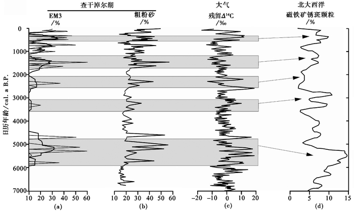
查干淖尔湖沉积物记录显示LOL550总体呈降低趋势,细颗粒组分逐步降低,粗颗粒组分逐步升高,表明近7000年以来流域气候逐渐恶化,东亚夏季风总体呈现减弱趋势(图 4),并存在百年尺度上的气候波动(图 6)。湖区存在5次较为显著的百年尺度上的干旱事件,它们分别发生在5800~4700cal.a B.P.、3500~3100cal.a B.P.、2600~2100cal.a B.P.、1700~1200cal.a B.P.和560~370cal.a B.P.期间。达里湖沉积物地球化学指标的研究发现[18],中晚全新世以来达里湖区在5800~5300cal.a B.P.、4250~4000cal.a B.P.、3200~2800cal.a B.P.、1650~1150cal.a B.P.和650~300cal.a B.P.期间气候干旱,表明这几个时期是东亚季风减弱的阶段。我们的记录中未发现达里湖记录中的4250~4000cal.a B.P.阶段的季风减弱状况[58],这可能是不同指标相对于气候变化的敏感性不同造成的。总体来说,查干淖尔湖记录与达里湖记录[18]反映的季风减弱阶段具有较好的一致性。对于岱海DH99a沉积岩芯的研究表明5600~5250cal.a B.P.、2900~2550cal.a B.P.、1600~1300cal.a B.P.、600~150cal.a B.P.期间,湖区降水显著减弱、湖泊水位下降[10, 63],这与查干淖尔湖记录也具有很好的一致性。
|
图 6 查干淖尔湖记录(a、b)与大气残留Δ14C[61] (c)、北大西洋磁铁矿锈斑颗粒含量[62] (d)对比 Fig. 6 Correlations of the record of the Chagan-Nuur, atmospheric residual Δ14C and hematite-stained grain concentrations in the North Atlantic sediments |
东亚季风在低纬向高纬的水汽传输过程中起着重要作用,同时也是控制研究区域的主要季风系统[64]。中晚全新世以来,由于太阳辐射的降低,导致东亚季风逐步减弱[3, 65]。千年尺度上,查干淖尔湖沉积物粒度、烧失量、EM1和EM3的变化表明7000年以来流域气候逐渐变干,说明7000年以来东亚夏季风强度逐渐减弱[3],这与内蒙古地区已有的气候记录[13, 40, 57~60]具有很好的一致性。因此,东亚季风是研究区千年尺度的气候变化的主要影响因素。
亚洲季风是全球气候系统的一个重要组成部分,是一个海洋、陆地和大气相互作用的动态气候系统[66~69]。季风环流受陆地与海洋之间气压分布的季节性变化影响[70],由于海洋相对于陆地来说储存热量的能力更强,当太阳辐射量发生变化时海洋温度相对于陆地温度来说变化幅度更小,这样海洋与陆地之间的气压梯度就会产生变化[63],因此影响季风环流的根本原因是太阳轨道和太阳能量输出在千年尺度上的变化造成的太阳辐射量的波动[71, 72]。太阳辐射量降低时,一方面会导致北半球接收的太阳辐射量减少,使亚洲大陆与太平洋之间的热力差异减小,进而导致东亚夏季风强度降低[73];另一方面会使热带太平洋地区海表温度降低、蒸发量减弱,使东亚夏季风带入亚洲大陆内部的气团的水汽含量减少,从而导致季风边缘区降水减少[74]。而太阳辐射量降低时,也会使北半球高纬地区温度下降[62],形成大西洋涛动的低指数环流和极地震荡的负相位现象,进而导致极地环流范围向南移动,寒冷的极地气流进入中纬度地区[18]。而极地环流的增强会阻碍东亚夏季风环流向北移动[75],从而导致季风降水减弱,季风边缘区干旱。查干淖尔湖沉积物中记录的近7000年以来的东亚季风减弱与大气残留Δ14C增加指示的太阳活动减弱[61](图 6c)、北大西洋极端冷事件[62](图 6d)在定年误差范围内具有很好的一致性。因此,百年尺度上的东亚季风强弱变化可能受高纬气候变化和太阳活动的共同影响。
5 结论通过对内蒙古中东部查干淖尔湖剖面的研究,得出如下结论:
(1) 利用该湖沉积物全有机质的14C测年,存在大约1470年的“碳库效应”。
(2) 粘土组分、端元组分分析的端元EM1、烧失量LOI550增高,中值粒径减小,指示气候相对湿润;粗粉砂组分、端元组分分析的端元EM3、中值粒径增加,烧失量LOI550减少,指示气候干旱。
(3) 千年尺度上,中晚全新世以来研究区气候逐步变干,但6900~5800cal.a B.P.、4500~2000cal.a B.P.期间气候相对湿润,而5800~4500cal.a B.P.、2000~0cal.a B.P.时期气候干旱,这种气候的变化与区域内其他记录一致性较好。中晚全新世以来千年尺度上的气候总体变干,与太阳辐射的逐步减低造成的东亚季风的减弱有关。百年尺度上,查干淖尔湖经历了5次较为明显的干旱事件,分别发生于5800~4700cal.a B.P.、3500~3100cal.a B.P.、2600~2100cal.a B.P.、1700~1200cal.a B.P.和560~370cal.a B.P.,这些干旱事件的发生,在定年误差范围内,与太阳活动减弱事件和北大西洋冰漂碎屑事件基本一致,表明百年尺度上东亚季风强度的变化受北半球高纬气候和太阳活动的共同影响。
致谢 感谢编辑杨美芳老师和审稿专家提出的建设性修改意见!感谢聂保锋、倪振宇、陈钰、张博威、李俊峰等在样品采集方面给予的帮助!
| 1 |
Wanner H, Solomina O, Grosjean M et al. Structure and origin of Holocene cold events. Quaternary Science Reviews, 2011, 30(21~22): 3109-3123. |
| 2 |
Sun Jimin, Li Shenghua, Han Peng et al. Holocene environmental changes in the central Inner Mongolia, based on single-aliquot-quartz optical dating and multi-proxy study of dune sands. Palaeogeography, Palaeoclimatology, Palaeoecology, 2006, 233(1~2): 51-62. |
| 3 |
Herzschuh U. Palaeo-moisture evolution in monsoonal Central Asia during the last 50, 000 years. Quaternary Science Reviews, 2006, 25(1~2): 163-178. |
| 4 |
Zhou Weijian, Lu Xuefeng, Wu Zhengkun et al. Peat record reflecting Holocene climatic change in the Zoigê Plateau and AMS radiocarbon dating. Chinese Science Bulletin, 2002, 47(1): 66-70. DOI:10.1360/02tb9013 |
| 5 |
Feng Z D, An C B, Tang L Y et al. Stratigraphic evidence of a megahumid climate between 10, 000 and 4000 years B.P. in the western part of the Chinese Loess Plateau. Global and Planetary Change, 2004, 43(3): 145-155. |
| 6 |
凌光久, 贾玉连, 马春梅等. 内蒙古黄旗海中晚全新世(3580~1630cal.a B.P.)气候环境记. 第四纪研究, 2016, 36(2): 257-267. Ling Guangjiu, Jia Yulian, Ma Chunmei et al. Mid-Late Holocene(3580~1630cal.a B.P.)climate and environment records from Huangqihai Lake in Inner Mongolia. Quaternary Sciences, 2016, 36(2): 257-267. |
| 7 |
姜雅娟, 王维, 马玉贞等. 内蒙古鄂尔多斯高原泊江海子全新世气候变化初步研究. 第四纪研究, 2014, 34(3): 654-665. Jiang Yajuan, Wang Wei, Ma Yuzhen et al. A preliminary study on Holocene climate change of Ordos Plateau, as inferred by sedimentary record from Bojianghaizi Lake of Inner Mongolia, China. Quaternary Sciences, 2014, 34(3): 654-665. |
| 8 |
Wang Xu, Cui Linlin, Xiao Jule et al. Stable carbon isotope of black carbon in lake sediments as an indicator of terrestrial environmental changes:An evaluation on paleorecord from Daihai Lake, Inner Mongolia, China. Chemical Geology, 2013, 347(4): 123-134. |
| 9 |
Xue Bin, Qu Wenchuan, Wang Sumin et al. Lake level changes documented by sediment properties and diatom of Hulun Lake, China since the Late Glacial. Hydrobiologia, 2003, 498(1): 133-141. |
| 10 |
Xiao Jule, Wu Jintao, Si Bin et al. Holocene climate changes in the monsoon/arid transition reflected by carbon concentration in Daihai Lake of Inner Mongolia. The Holocene, 2006, 16(4): 551-560. DOI:10.1191/0959683606hl950rp |
| 11 |
Xiao Jule, Fan Jiawei, Zhou Lang et al. A model for linking grain-size component to lake level status of a modern clastic lake. Journal of Asian Earth Sciences, 2013, 355(12): 149-158. |
| 12 |
Xiao J L, Nakamura T, Lu H Y et al. Holocene climate changes over the desert/loess transition of North-Central China. Earth and Planetary Science Letters, 2002, 197(1~2): 11-18. |
| 13 |
Chen C T A, Lan H C, Lou J Y et al. The dry Holocene megathermal in Inner Mongolia. Palaeogeography, Palaeoclimatology, Palaeoecology, 2003, 193(2): 181-200. DOI:10.1016/S0031-0182(03)00225-6 |
| 14 |
Bond G, Kromer B, Evans M N et al. Persistent solar influence on North Atlantic climate during the Holocene. Science, 2002, 294(5549): 2130-2136. |
| 15 |
Bond G, Showers W, Cheseby M et al. A pervasive millennial-scale cycle in North Atlantic Holocene and glacial climates. Science, 1997, 278(5341): 1257-1266. DOI:10.1126/science.278.5341.1257 |
| 16 |
Hong Y T, Hong B, Lin Q H et al. Correlation between Indian Ocean summer monsoon and North Atlantic climate during the Holocene. Earth and Planetary Science Letters, 2003, 211(3~4): 371-380. |
| 17 |
Wang Y J, Cheng H, Edwards R L et al. The Holocene Asian monsoon:Links to solar changes and North Atlantic climate. Science, 2005, 308(5723): 854-857. DOI:10.1126/science.1106296 |
| 18 |
Fan Jiawei, Xiao Jule, Wen Ruilin et al. Droughts in the East Asian summer monsoon margin during the last 6 kyrs:Link to the North Atlantic cooling events. Quaternary Science Reviews, 2016, 151(9): 88-99. |
| 19 |
刘美萍, 哈斯. 中全新世以来查干淖尔古湖面波动. 中国沙漠, 2015, 35(2): 306-312. Liu Meiping, Hasi Eerdun. Middle Holocene paleolake fluctuation of the Chagan-Nuur, Inner Mongolia. Journal of Desert Research, 2015, 35(2): 306-312. DOI:10.7522/j.issn.1000-694X.2014.00050 |
| 20 |
李振刚. 克什克腾旗志. 呼和浩特: 内蒙古人民出版社, 1993, 1-1144. Li Zhengang. Annals of Hexigten Banner. Hohhot: People's Press of Inner Mongolia, 1993, 1-1144. |
| 21 |
陆岸青, 李珍, 李杰等. 越南红河流域沉积物的镜下碳屑分析实验室处理方法对比研究. 第四纪研究, 2009, 29(4): 825-830. Lu Anqing, Li Zhen, Li Jie et al. Comparative experiments of extracting charcoals from sediment with microscope in the Red River basin, Vietnam. Quaternary Sciences, 2009, 29(4): 825-830. |
| 22 |
Heiri O, Lotter A F, Lemcke G. Loss on ignition as a method for estimating organic and carbonate content in sediments:Reproducibility and comparability of results. Journal of Paleolimnology, 2000, 25(1): 101-110. |
| 23 |
王君波, 朱立平. 不同前处理对湖泊沉积物粒度测量结果的影响. 湖泊科学, 2005, 17(1): 17-23. Wang Junbo, Zhu Liping. Influence of different pre-treatments on grain-size measurement of lake sediments. Journal of Lake Science, 2005, 17(1): 17-23. |
| 24 |
Weltje G J. End-member modeling of compositional data:Numerical-statistical algorithms for solving the explicit mixing problem. Mathematical Geosciences, 1997, 29(4): 503-549. |
| 25 |
Weltje G J, Prins M A. Muddled or mixed?Inferring palaeoclimate from size distributions of deep-sea clastics. Sedimentary Geology, 2003, 162(1~2): 39-62. |
| 26 |
Weltje G J, Prins M A. Genetically meaningful decomposition of grain-size distributions. Sedimentary Geology, 2007, 202(3): 409-424. DOI:10.1016/j.sedgeo.2007.03.007 |
| 27 |
Hou Juzhi, D'Andrea W J, Liu Zhonghui. The influence of 14C reservoir age on interpretation of paleolimnological records from the Tibetan Plateau. Quaternary Science Reviews, 2012, 48(33): 67-79. |
| 28 |
周卫建, 周杰, 萧家仪等. 花粉浓缩物的加速器14C年代测定初探. 中国科学(D辑), 1998, 28(5): 453-458. Zhou Weijian, Zhou Jie, Xiao Jiayi et al. Pollen concentrations of the accelerator of 14C dating. Science in China (Series D), 1998, 28(5): 453-458. |
| 29 |
Watanabe T, Matsunaka T, Nakamura T et al. A new 14C data set of the PY608W-PC sediment core from Lake Pumoyum Co(southeastern Tibetan Plateau)over the last 19 kyr. Radiocarbon, 2010, 52(3): 1435-1442. DOI:10.1017/S0033822200046518 |
| 30 |
Blaauw M, Christen J A. Flexible paleoclimate age-depth models using an autoregressive gamma process. Bayesian Analysis, 2011, 6(6): 457-474. |
| 31 |
Jr W E D. Determination of carbonate and organic matter in calcareous sediments and sedimentary rocks by loss on ignition:Comparison with other methods. Journal of Sedimentary Research, 1974, 44(1): 242-248. |
| 32 |
Heiri O, Lotter A F, Lemcke G. Loss on ignition as a method for estimating organic and carbonate content in sediments:Reproducibility and comparability of results. Journal of Paleolimnology, 2001, 25(1): 101-110. DOI:10.1023/A:1008119611481 |
| 33 |
Santisteban J I, Mediavilla R, López-Pamo E et al. Loss on ignition:A qualitative or quantitative method for organic matter and carbonate mineral content in sediments?. Journal of Paleolimnology, 2004, 32(3): 287-299. DOI:10.1023/B:JOPL.0000042999.30131.5b |
| 34 |
Dodson J R, Ramrath A. An Upper Pliocene lacustrine environmental record from south-Western Australia——Preliminary results. Palaeogeography, Palaeoclimatology, Palaeoecology, 2001, 167(3): 309-320. |
| 35 |
Ramrath A, Zolitschka B, Wulf S et al. Late Pleistocene climatic variations as recorded in two Italian maar lakes(Lago di Mezzano, Lago Grande di Monticchio). Quaternary Science Reviews, 1999, 18(7): 977-992. DOI:10.1016/S0277-3791(99)00009-8 |
| 36 |
Chen Fahu, Zhu Yan, Li Jijun et al. Abrupt Holocene changes of the Asian monsoon at millennial-and centennial-scales:Evidence from lake sediment document in Minqin Basin, NW China. Chinese Science Bulletin, 2001, 46(23): 1942. DOI:10.1007/BF02901902 |
| 37 |
Bakke J, Dahl S O, Øyvind Paasche et al. A complete record of Holocene glacier variability at Austre Okstindbreen, Northern Norway:An integrated approach. Quaternary Science Reviews, 2010, 29(9~10): 1246-1262. |
| 38 |
Luo Jianyu, Chen Zhendong. Paleoclimatological and paleoenvironmental records since 4000a B.P. in sediments of alpine lakes in Taiwan. Science in China:Scientia Geographica Sinica, 1997, 40(4): 424-431. |
| 39 |
Pedersen T F, Calvert S E. Anoxia vs. productivity:What controls the formation of organic-carbon-rich sediments and sedimentary rocks?. Aapg Bulletin, 1990, 74(4): 454-466. |
| 40 |
范佳伟, 肖举乐, 温瑞林等. 内蒙古达里湖全新世有机碳氮同位素记录与环境演变. 第四纪研究, 2015, 35(4): 856-870. Fan Jiawei, Xiao Jule, Wen Ruilin et al. Holocene environment variations recorded by stable carbon and nitrogen isotopes of sedimentary organic matter from Dali Lake in Inner Mongolia. Quaternary Sciences, 2015, 35(4): 856-870. |
| 41 |
黄麒, 孟昭强, 刘海玲. 柴达木盆地察尔汗湖区古气候波动模式的初步研究. 中国科学(D辑), 1990, 20(6): 94-105. Huang Qi, Meng Zhaoqiang, Liu Hailing. A preliminary study of Qaidam Basin Charhan Lake climatic fluctuation model. Science in China(Series D), 1990, 20(6): 94-105. |
| 42 |
薛滨, 王苏民, 沈吉等. 呼伦湖东露天矿剖面有机碳的总量及其稳定碳同位素和古环境演化. 湖泊科学, 1994, 6(4): 308-316. Xue Bin, Wang Sumin, Shen Ji et al. Total organic carbon and its stable carbon isotope and paleoenvironmental evolution of Donglutian coal profile, Hulun Lake. Journal of Lake Sciences, 1994, 6(4): 308-316. DOI:10.18307/1994.0403 |
| 43 |
Shen Ji, Liu Xingqi, Wang Sumin et al. Palaeoclimatic changes in the Qinghai Lake area during the last 18, 000 years. Quaternary International, 2005, 136(1): 131-140. DOI:10.1016/j.quaint.2004.11.014 |
| 44 |
Zhu Liping, Chen Ling, Li Bingyuan et al. Environmental changes reflected by the lake sediments of the South Hongshan Lake, Northwest Tibet. Science in China(Series D), 2002, 45(5): 430-439. DOI:10.1360/02yd9045 |
| 45 |
Liu Xingqi, Dong Hailiang, Rech Jason A et al. Evolution of Chaka Salt Lake in NW China in response to climatic change during the Latest Pleistocene-Holocene. Quaternary Science Reviews, 2008, 27(7~8): 867-879. |
| 46 |
Ramírez R, Dem C E. Diurnal vertical and among sampling days variation of dissolved O2, CO2 and pH in a shallow tropical reservoir(Garças reservoir São Paulo Brazil). Acta Limnologica Brasiliensia, 2003, 15(3): 19-30. |
| 47 |
Liu Xingqi, Dong Hailiang, Yang Xiangdong et al. Late Holocene forcing of the Asian winter and summer monsoon as evidenced by proxy records from the northern Qinghai-Tibetan Plateau. Earth and Planetary Science Letters, 2009, 280(1): 276-284. |
| 48 |
范佳伟, 肖举乐, 温锐林等. 达里湖沉积粒度组分-湖面状况定量模型. 第四纪研究, 2016, 36(3): 612-622. Fan Jiawei, Xiao Jule, Wen Ruilin et al. A model for the linkage between grain-size component in the Dali Lake sediments and lake level status. Quaternary Sciences, 2016, 36(3): 612-622. |
| 49 |
Chen Jing'an, Wan Guojiang, Zhang David Dia et al. Environmental records of lacustrine sediments in different time scales:Sediment grain size as an example. Science in China (Series D), 2004, 47(10): 954-960. DOI:10.1360/03yd0160 |
| 50 |
郭超, 马玉贞, 刘杰瑞等. 过去2000年来西藏羊卓雍错沉积物粒度记录的气候变化. 第四纪研究, 2016, 36(2): 405-419. Guo Chao, Ma Yuzhen, Liu Jierui et al. Climatic change recorded by grain size in the past about 2000 years from Yanzhog Yumco Lake, Tibet. Quaternary Sciences, 2016, 36(2): 405-419. |
| 51 |
Liu Xingqi, Herzschuh U, Shen Ji et al. Holocene environmental and climatic changes inferred from Wulungu Lake in northern Xinjiang, China. Quaternary Research, 2008, 70(3): 412-425. DOI:10.1016/j.yqres.2008.06.005 |
| 52 |
Håkanson L, Jansson M. Principles of Lake Sedimentology. Berlin: Springer, 1983, 316.
|
| 53 |
Sun Donghuai, Bloemendal J, Rea D K et al. Bimodal grain-size distribution of Chinese loess, and its palaeoclimatic implications. Catena, 2004, 55(3): 325-340. DOI:10.1016/S0341-8162(03)00109-7 |
| 54 |
Dietze E, Lockot G, Kai H et al. Early to Mid-Holocene lake high-stand sediments at Lake Donggi Cona, northeastern Tibetan Plateau, China. Quaternary Research, 2013, 79(3): 325-336. DOI:10.1016/j.yqres.2012.12.008 |
| 55 |
李德文, 康艳蕊, 李大伟. 基于动态图像法的河流砂和湖滩砂粒形-粒度特征对比. 第四纪研究, 2015, 35(2): 484-492. Li Dewen, Kang Yanrui, Li Dawei. Comparison of grain-size and grain-shape characters of alluvial and lakeshore sands based on dynamic image analysis. Quaternary Sciences, 2015, 35(2): 484-492. DOI:10.11928/j.issn.1001-7410.2015.02.23 |
| 56 |
Dietze E, Kai H, Diekmann B et al. An end-member algorithm for deciphering modern detrital processes from lake sediments of Lake Donggi Cona, NE Tibetan Plateau, China. Sedimentary Geology, 2012, 243(1): 169-180. |
| 57 |
靳鹤龄, 苏志珠, 孙良英等. 浑善达克沙地全新世气候变化. 科学通报, 2004, 49(15): 1532-1536. Jin Heling, Su Zhizhu, Sun Liangying et al. Holocene climate change of Hunshandake sandy land. Chinese Science Bulletin, 2004, 49(15): 1532-1536. DOI:10.3321/j.issn:0023-074X.2004.15.012 |
| 58 |
Xiao Jule, Chang Zhigang, Si Bin et al. Partitioning of the grain-size components of Dali Lake core sediments:Evidence for lake-level changes during the Holocene. Journal of Paleolimnology, 2009, 42(2): 249-260. DOI:10.1007/s10933-008-9274-7 |
| 59 |
Xiao Jule, Xu Qinghai, Nakamura T et al. Holocene vegetation variation in the Daihai Lake region of north-central China:A direct indication of the Asian monsoon climatic history. Quaternary Science Reviews, 2004, 23(14~15): 1669-1679. |
| 60 |
Wen Ruilin. Holocene climate changes in the mid-high-latitude-monsoon margin reflected by the pollen record from Hulun Lake, northeastern Inner Mongolia. Quaternary Research, 2010, 73(2): 293-303. DOI:10.1016/j.yqres.2009.10.006 |
| 61 |
Reimer P J, Bard E, Bayliss A et al. IntCal13 and marine13 radiocarbon age calibration curves 0~50, 000 years cal BP. Radiocarbon, 2013, 51(4): 1111-1150. |
| 62 |
Bond G, Kromer B, Evans M N et al. Persistent solar influence on North Atlantic climate during the Holocene. Science, 2001, 294(5549): 2130. DOI:10.1126/science.1065680 |
| 63 |
Peng Yanjia, Xiao Jule, Nakamura T et al. Holocene East Asian monsoonal precipitation pattern revealed by grain-size distribution of core sediments of Daihai Lake in Inner Mongolia of north-central China. Earth and Planetary Science Letters, 2005, 233(3~4): 467-479. |
| 64 |
An Zhisheng. The history and variability of the East Asian paleomonsoon climate. Quaternary Science Reviews, 2000, 19(1~5): 171-187. |
| 65 |
Overpeck J, Anderson D, Trumbore S et al. The southwest Indian monsoon over the last 18000 years. Climate Dynamics, 1996, 12(3): 213-225. DOI:10.1007/BF00211619 |
| 66 |
Gao Youxi. Some Questions about the East Asian Monsoon. Beijing: Science Press, 1962, 1-49.
|
| 67 |
Chinese Academy of Sciences(Compilatory Commission of Physical Geography of China). Physical Geography of China:Climate. Beijing: Science Press, 1984, 1-30.
|
| 68 |
黄恩清. 中更新世以来东亚冬季风海陆记录对比. 第四纪研究, 2015, 35(6): 1331-1341. Huang Enqing. A comparison of the East Asian winter monsoon reconstructions from terrestrial and marine sedimentary records since the Mid-Pleistocene. Quaternary Sciences, 2015, 35(6): 1331-1341. |
| 69 |
韩春凤, 刘健, 王志远. 过去2000年亚洲夏季风降水百年尺度变化及其区域差异的模拟分析. 第四纪研究, 2016, 36(3): 732-746. Han Chunfeng, Liu Jian, Wang Zhiyuan. Simulated analysis of Asian summer monsoon precipitation on centennial time scale and its regional differences over the past 2000 years. Quaternary Sciences, 2016, 36(3): 732-746. |
| 70 |
Li Chengfeng, Ma Yanai. The onset and interannual variability of the Asian summer monsoon in relation to land-sea thermal contrast. Chinese Science Bulletin, 1996, 9(2): 358-375. |
| 71 |
Wang Pinxian, Clemens S, Beaufort L et al. Evolution and variability of the Asian monsoon system:State of the art and outstanding issues. Quaternary Science Reviews, 2005, 24(5): 595-629. |
| 72 |
李伟, 陈仕涛, 吴帅男等. 东亚季风"2.8ka"事件高分辨率的石笋记录. 第四纪研究, 2014, 34(6): 1256-1263. Li Wei, Chen Shitao, Wu Shuainan et al. A high resolution East Asian monsoon record around 2.8ka B.P. from Mt. Shennongjia, Central China. Quaternary Sciences, 2014, 34(6): 1256-1263. |
| 73 |
An Zhisheng, Porter S C, Kutzbach J E et al. Asynchronous Holocene Optimum of the East Asian monsoon. Quaternary Science Reviews, 2000, 19(8): 743-762. DOI:10.1016/S0277-3791(99)00031-1 |
| 74 |
Xiao Jule, Si Bin, Zhai Dayou et al. Hydrology of Dali Lake in central-eastern Inner Mongolia and Holocene East Asian monsoon variability. Journal of Paleolimnology, 2008, 40(1): 519-528. DOI:10.1007/s10933-007-9179-x |
| 75 |
Sung M, Kwon W, Baek H et al. A possible impact of the North Atlantic Oscillation on the East Asian summer monsoon precipitation. Geophysical Research Letters, 2006, 33(33): 493-495. |
Abstract
Whether the climate is humid in Early-Middle or in Middle Holocene still remains a question in East Asian monsoonal regions. Meanwhile, the Holocene climate instability has become one of the research hotspot. The middle-east part of Inner Mongolia is located in the transitional zone between East Asian monsoon and Westerlies, which is sensitive to the monsoon intensity and global climate change. A continuous 3-m sediment profile was recovered from Chagan-Nuur in middle-east part of Inner Mongolia (43°25'49"N, 114°57'26"E; 1008m a.s.l.). Radiocarbon ages on bulk organic carbon and charcoal determined by accelerator mass spectrometry (AMS)are used to establish the chronology of the profile. Loss on ignition, grain-size and its end-member analysis of the profile were used to infer climate conditions. The increase of clay content, EM1, and LOI 550 values, and the decrease of median diameter, indicate relatively humid climate, and vice versa. Thus we reconstructed the climate changes in the middle-east part of Inner Mongolia during the last 7000 years. The results show that, on the millennial scale, the climate in the study area is gradually drying up in recent 7000 years, which is related to the weakening of East Asian monsoon produced by gradually reducing of solar radiation. However, the climate is relative wet during the periods of 6900~5800cal.a B.P. and 4500~2000cal.a B.P., while the climate is dry during the periods of 5800~4500cal.a B.P. and 2000~0cal.a B.P. On the centennial scale, Chagan-Nuur has experienced five obvious drought events, which occurred during 5800~4700cal.a B.P., 3500~3100cal.a B.P., 2600~2100cal.a B.P., 1700~1200cal.a B.P. and 560~370cal.a B.P. These drought events, within the dating errors, are consistent with the solar activity weakening events and the North Atlantic ice rafting events, showing that East Asian monsoon intensity on centennial scale is probably affected by the high latitude climate and the solar activities. 2017, Vol.37

