 2016, Vol.36

② 中国地震局地壳应力研究所, 北京 100085)
全球变化研究中的一个重要方面是研究地质历史时期的气候变化[1]。亚洲内陆作为中纬度温带干旱区的主体,对全球气候产生着很大影响,而我国西北干旱区又是亚洲内陆的主体[2],因此是研究亚洲内陆干旱化过程及其驱动机制、亚洲粉尘来源和大气环流变化等重要科学问题的关键区域之一[3, 4]。黄土是地质历史时期一种连续的陆源沉积物,主要分布在欧洲西北部、中亚地区以及我国黄土高原地区(图 1)[5]。由于黄土在形成过程中受到地理背景、气候条件等因素的影响,因此其富含丰富的古气候信息[1],这对研究东亚季风演变[6, 7]、第四纪冰期-间冰期气候旋回[1, 8]和西北内陆干旱化[9]等具有重要意义。

|
图 1 中国及中亚地区黄土分布示意图[5] Fig. 1 Distribution of loess sediments in Central Asia and China, after reference[5] |
目前对于黄土的研究主要集中在我国黄土高原地区[1, 10~14],对于分布在我国西北山麓带的黄土研究相对不足。与黄土高原的气候主要受东亚季风影响不同,我国西北地区,尤其是天山地区的气候则显著受到西风带的影响。不同的气候条件与气候演化历史应该可以通过风尘黄土研究进行重建。在我国黄土高原地区,黄土粒度组分中的粗颗粒含量(如>63μm的砂粒组分)已被证明与冬季风强度成正相关关系[9, 15, 16],可作为冬季风强度的代用指标。各种磁学参数如表示磁性颗粒粒度的参数(χARM/χlf、 χARM/SIRM)、磁化率(χlf)被用来指示夏季风强弱的变化[17]。前人对于天山地区黄土磁学性质与控制因素以及其记录的古气候历史等方面开展了相关研究[4, 18~24],但考虑到西北地区山麓黄土分布相对广泛,这些方面的研究仍需加强。为进一步揭示天山地区黄土磁学性质及古气候意义,本文选择天山北麓柴窝堡盆地南缘乌鲁木齐河T7阶地上覆黄土为研究对象,基于光释光年代学、沉积学与岩石磁学等分析,尝试进一步探讨该地区古环境演化历史。
1 区域背景天山山脉为东西走向,平均海拔约4000m,是中亚最大、最活跃的山系之一。受印度-欧亚板块碰撞的影响,天山在新生代构造复活再造山[25~27]。天山南北两麓及山间盆地发育一系列河流(图 2)[28, 29],河流补给主要来自冰川和冰雪融水,具有明显的季节性变化[30]。在天山北麓海拔700~2400m地带广泛分布着更新世黄土堆积[2, 31],黄土厚度自山前至前陆盆地向北先变厚再变薄,最厚的地方位于塔西河与金沟河之间[2]。天山北麓发育3排逆断裂-褶皱带(图 2),黄土分布基本上以第3排逆断裂-褶皱带为北界,南至准噶尔南缘断裂和云杉林带,并与天山北麓主要河流的高阶地与早期冲积扇存在明显的依附关系[28, 32]。

|
图 2 基于数字高程模型(DEM)的天山北麓构造与地貌特征[28, 29]五角星标识本文研究的乌鲁木齐河山前T7阶地上覆黄土剖面 Fig. 2 Digital elevation model(DEM)map of the northern Tian Shan foreland showing tectonic setting[28, 29].Star shows the location of Ürümqi River section(URS) |
本文的研究区域位于新疆天山北麓柴窝堡盆地南缘乌鲁木齐河山前(图 2)。乌鲁木齐河发源于北天山喀拉乌成山的主峰天格尔峰北坡一号冰川,向东北出南山,至乌拉泊附近折向正北,穿过乌鲁木齐市,至昌吉市北部逐渐消失。河流在南山段下切作用明显,形成深切峡谷,出南山后进入柴窝堡盆地南缘。乌鲁木齐河强烈下切导致在南山山前形成了9级阶地[33]。柴窝堡盆地年降雨集中在夏季,降水大约100~200mm/年[34],主要受到西风带控制[35]。
2 研究剖面与分析方法研究剖面位于天山北麓柴窝堡盆地南缘乌鲁木齐河T7阶地上(43°30′02.77″N,87°19′26.53″E;海拔1673m,以下称为乌鲁木齐河剖面URS),剖面厚约8.6m。该剖面黄土颜色呈现灰黄色,整个剖面未观察到颜色有明显变化(图 3),基本不分层。野外垂直采样间隔为5cm,共采集173个样品。为确定黄土堆积年代,分别在0.5m、 3.5m和6.8m处采集了3个光释光年代样品U4、 U5和U6,在中国地震局地壳应力研究所光释光年代学实验室完成年代测定。

|
图 3 乌鲁木齐河T7阶地黄土剖面U4、 U5和U6标示光释光样品的采样位置 Fig. 3 The about 8.6-m-thick loess sediments lying on the terrace deposits of T7 of the Vrümqi River and U4, U5 and U6 show the sampling sites of the OSL dating samples |
岩石磁学测试在华东师范大学河口海岸学国家重点实验室完成。所有样品在烘干箱中烘干,温度控制在35℃。称取约7.0g烘干样并用塑料保鲜膜包紧,装入磁学专用盒并压实。利用BartingtonMS2双频磁化率仪测量低频(0.47kHz)和高频(4.7kHz)磁化率(χlf,χhf),计算频率磁化率百分含量χfd %=[(χlf-χhf)/χlf]×100 %。利用Molspin交变退磁仪(交变磁场峰值100mT,直流磁场0.04mT)产生非磁滞剩磁(ARM),以Minispin旋转磁力仪测定ARM(本文表达为其磁化率形式χARM)。随后利用Molspin脉冲磁化仪获得样品在1T、 -100mT和-300mT磁场下的等温剩磁(IRM),并利用旋转磁力仪测定。本文将1T磁场中获得的IRM称为饱和等温剩磁(SIRM),并计算退磁参数S-100mT=[(SIRM-IRM-100mT)/(2×SIRM)]、 S-300mT=[(SIRM-IRM-300mT)/(2×SIRM)][36],以及SIRM/χlf、 χARM/χlf和χARM/SIRM。
每隔30cm选择一个样品(共29个样品)进行漫反射光谱测试。将在35℃下烘干的样品置于玛瑙研钵中进行研磨,之后将粉末状样品压进直径4cm的圆塑料环中。样品漫反射光谱测试所用仪器为Perkin Elmer Lambda 950UV/VIS spectrophotometer,测量光谱范围为400~700nm,步长为0.5nm,扫描速度为300nm/分钟,对实验数据进行一阶导数分析。一阶导数的波峰可用于指示粘土矿物及铁的氧化物的存在[37~39]。本研究中漫反射光谱测试在华东师范大学河口海岸学国家重点实验室完成。
本文对剖面中173个样品进行了沉积粒度分析。先用5 %的双氧水和0.2M的盐酸去除样品中的有机质和碳酸盐,之后向样品中加入0.5M的六偏磷酸钠((NaPO3)6)溶液并进行超声波震荡分散。充分震荡后的样品用于粒度测试,测试仪器为Mastersizer 2000激光粒度仪,测量范围0.04~2000μm。粒度测试在华东师范大学地理科学学院完成。
为探讨乌鲁木齐河剖面黄土沉积物源特征,本文选择部分样品进行了稀土元素分析,测试分析在同济大学海洋地质国家重点实验室完成。测试流程参考邵磊等[40]的方法,仪器为VGX7型电感耦合等离子质谱仪(ICP-MS),标准样GSR5、 GSR6和GSR9用来控制测试精度,测试误差小于2 %。计算轻稀土元素总量LREE(从La到Eu)、重稀土元素总量HREE(从Gd到Lu),并求得LREE/HREE与其平均值的差的绝对值;以及指示岩石形成过程中Ce、 Eu出现异常(亏损或富集)现象的δEu=EuN/Eu *=EuN/

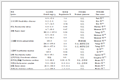
基于光释光测年结果,见表 1。得到乌鲁木齐河剖面底界6.8m处的年龄为约41ka,顶界年龄为约14ka。野外考察中没有发现剖面中存在明显的侵蚀-沉积间断,因此,初步推测该厚约8.6m的剖面黄土是在约50ka以来的晚更新世沉积,并且堆积过程是连续的。这一年代结果为分析乌鲁木齐河剖面黄土沉积粒度与磁学特征提供了时间标尺。根据沉积粒度和磁性特征的垂向变化,将乌鲁木齐河剖面划分为5层:第1层(8.6~6.8m)、第2层(6.8~4.1m)、第3层(4.1~2.4m)、第4层(2.4~0.8m)和第5层(0.8~0m)。
|
表 1 乌鲁木齐河剖面光释光测年结果 Table 1 Calculated values of equivalent doses, annual doses, and OSL ages of the Vrümqi River section |
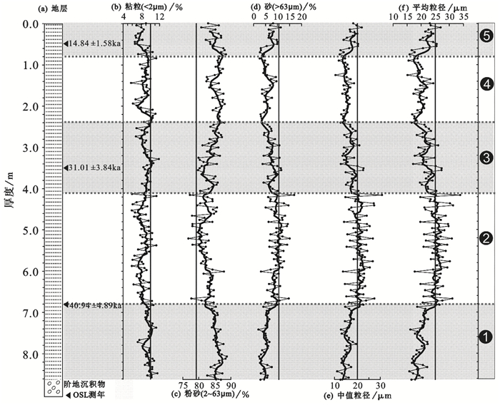
粒度三角图显示(图 4),在进行粒度分析的样品中,85 %的样品属于粉土,15 %的样品属于粉砂土。沉积粒度组成(图 5)主要为粉砂(2~63μm),该组分含量为76 %~89 %,样品中平均含量为84 %;粘粒组分( < 2μm)含量为5 %~12 %;砂粒组分(>63μm)的含量为2 %~17 %。

|
图 4 乌鲁木齐河剖面黄土粒度三角图 Fig. 4 Grain-size ternary diagram of the URS loess sediments |
沉积粒度垂向变化特征如下:第1层中,粉砂(图 5c)含量呈逐渐减小的趋势,砂粒(图 5d)含量呈现逐渐增大的趋势,与中值粒径(图 5e)和平均粒径(图 5f)的变化趋势一致,指示该层黄土堆积呈现逐渐增粗的趋势;第2层中,各粒度组分虽然存在一定波动,但总体呈现相对稳定的水平,黄土粒度未呈现趋势性变化(图 5b~5f);在第3层和第4层,粉砂(图 5c)含量呈逐渐增大的趋势,而砂粒(图 5d)含量呈现逐渐减小的趋势,与中值粒径(图 5e)和平均粒径(图 5f)的变化趋势一致,指示该层黄土逐渐变细,与第1层的变化相反;在第5层,砂粒(图 5d)含量显著增大到一个较高的水平,粉砂(图 5c)含量则明显减小,这指示该层黄土粒度显著变粗。
|
图 5 乌鲁木齐河剖面黄土沉积粒度特征(其中粗实线为5点滑动平均值) Fig. 5 Results of sediment grain size analysis of the URS loess sediments |
漫反射光谱分析(Diffuse Reflectance Spectroscopy,简称DRS)可以检测沉积物中是否存在针铁矿(Gt)和赤铁矿(Hm)等磁性矿物[37~39]。前人研究表明,在漫反射光谱一阶导数图中,赤铁矿的特征反射峰在555~575nm之间,其具体位置取决于赤铁矿含量或者成土型赤铁矿中铝的取代度[37~39]。在乌鲁木齐河剖面中,所有的黄土样品均展示在555nm处存在特征反射峰,表明该剖面黄土中存在赤铁矿(图 6)。

|
图 6 乌鲁木齐河剖面黄土样品漫反射光谱一阶导数图 Fig. 6 First derivative curves of 29 samples from the Ürümqi River section |
S-300mT通常反映低矫顽力矿物(如磁铁矿)与高矫顽力矿物(如赤铁矿、针铁矿)的相对比例[43];S-100mT反映低矫顽力矿物与中-高矫顽力矿物的相对比例[44, 45];中矫顽力矿物主要包括磁赤铁矿等[46]。乌鲁木齐河剖面黄土样品绝大部分的S-300mT在96 %~98 %之间(图 7i),表明低矫顽力矿物(如亚铁磁性矿物)在磁性矿物组分中主导地位,但存在高矫顽力磁性矿物。在第1层、第2层中,S-300mT在8.6~7.6m间呈增加趋势,在7.6~6.9m呈减少趋势;第3层再次呈现增加趋势,第4层、第5层呈波动增加到1.05m后呈减少趋势;在整个剖面中,S-300mT值表现出随高度上升而减少的趋势(图 7i)。S-100mT在第1~4层中,8.6~0.8m与S-300mT具有相似的变化趋势(图 7h),而在0.8m以上的部分,S-100mT值变化与S-300mT值相反,其值由约71 %增加到约76 %(图 7h),并且样本S-100mT与磁化率(χlf)呈现一定的正相关关系(图 8a)。具有较高S-100mT值的样本,磁化率也比较高。以上这些观察并结合剖面变化说明,中矫顽力矿物(如磁赤铁矿)对磁化率有一定贡献,而高矫顽力矿物的贡献则非常有限。

|
图 7 乌鲁木齐河剖面黄土磁学性质(其中粗实线为11点滑动平均值) Fig. 7 Lithology, chronology, and rock magnetic results of the Vrümqi River section |
低频磁化率(χlf)和饱和等温剩磁(SIRM)通常反映样品中亚铁磁性矿物(如磁铁矿)的含量,与χlf不同的是SIRM不受顺磁性和抗磁性矿物的影响[46]。根据该剖面χlf与SIRM的正相关关系(图 8b),以及两参数在剖面中一致的变化趋势(图 7b和7d),说明乌鲁木齐河剖面黄土的χlf信号主要由亚铁磁性矿物主导。在乌鲁木齐河剖面中,χlf值在40×10-8~69×10-8m3/kg,其平均值为50.4×10-8m3/kg,在第1层中χlf从约40×10-8m3/kg增加至约62×10-8m3/kg后减少至约50×10-8m3/kg,随后第2层值较为稳定,呈现微减少趋势,而第3~5层呈现波动增加的趋势(图 7b)。SIRM值变化趋势基本与χlf一致(图 7d)。非磁滞剩磁(χARM)是对稳定单畴(SSD)亚铁磁性矿物颗粒极为敏感的磁性参数[47, 48]。在第1层中,χARM值呈现出明显的减少趋势,除第2层和第4层两处显著低值外,第2~5层χARM呈现增加趋势(图 7e),逐渐趋同于χlf及SIRM变化趋势(图 7b和7d)。说明样品中亚铁磁性矿物含量在第1层中存在一段时间的高值,而在41ka以后趋于平稳,并呈现出逐渐增多的趋势。
3.2.3 磁性矿物粒度频率磁化率百分含量(χfd %)反映了超顺磁(SP)与单畴(SD)临界点附近细粘滞性超顺磁颗粒(约0.03μm)对磁化率的贡献[46],一般当χfd %大于5 %时,说明沉积物中SP颗粒主导[17, 46]。对于乌鲁木齐河剖面黄土堆积,χfd %不超过3 %(图 7c),说明该剖面黄土中SP颗粒在磁性矿物组分中不是主导成分。
比值参数χARM/χlf和χARM/SIRM常被用作指示磁性矿物颗粒大小,高值反映较细的单畴颗粒,低值指示了较粗的多畴颗粒[48, 49],χARM/χlf和χARM/SIRM分别与χlf进行的相关性分析结果显示,具有低值的χARM/χlf和χARM/SIRM的样本,χlf值较高(图 8c和8d)。样品中含有大量的SP颗粒,也可能造成χARM/χlf低值[17]。在乌鲁木齐河剖面中,χfd %值较低(图 7c),指示该剖面黄土堆积中SP颗粒的低含量,因此在该剖面中参数χARM/χlf的大小不受SP颗粒的显著影响。χARM/χlf和χARM/SIRM呈现出一致的变化趋势(图 7f和7g),在第1层呈现下降趋势,而且χARM/SIRM出现剖面最低值,在第2层中波动上升,第3~5层呈现波动下降趋势。磁性矿物粒度在剖面中的变化与χARM/χlf和χARM/SIRM的值的上述变化所指示的趋势相反。

|
图 8 磁学参数之间的相关关系 Fig. 8 Correlations among rock magnetic parameters |
通常,陆相沉积物的磁学性质主要受沉积物源、沉积物粒度以及沉积后的次生变化等因素控制[17, 29, 46, 50~52]。碎屑沉积物或沉积岩的稀土元素主要受沉积物源控制,搬运、沉积分选及成岩作用的影响相对较小[53, 54]。乌鲁木齐河黄土剖面典型样品的稀土元素配分模式非常一致(图 9a),基本没有差别。而REE参数三角图也可以提取源区信息[41, 42, 55~58]。研究剖面典型样品在稀土元素特征参数三角图(图 9b)中分布也十分集中,各参数差异很小。稀土元素的上述特征可能表明该乌鲁木齐河剖面晚更新世黄土堆积的物源相对稳定,没有发生过显著调整。因此,沉积物源调整应该不是导致乌鲁木齐河剖面黄土磁性特征变化的主要因素。

|
图 9 乌鲁木齐河剖面典型样品稀土元素配分模式(a)与稀土元素特征参数三角图(b) Fig. 9 Chondrite-normalized patterns of rare earth elements(REEs)(a)and the triangle diagram for the characteristic parameters of REEs(b)of the URS bulk sediments |
岩石磁学分析中χfd %表征与成土作用有关的SP颗粒的含量[59]。本文研究剖面中绝大部分样品的χfd % < 2 %(图 7c),说明乌鲁木齐河黄土剖面含有较少的SP磁性颗粒,因此认为,研究剖面中的黄土没有发生过明显的成土作用改造;另外,野外发现,乌鲁木齐河黄土剖面颜色均一,没有发现明显的分层现象(图 3),也佐证了剖面中没有发生过显著成土作用的观点。因此,推测剖面中黄土岩石磁学性质的显著变化不太可能主要由成土作用而导致。
排除了物源和成土作用对乌鲁木齐河剖面黄土磁学性质变化的主导作用,沉积粒度对黄土磁学性质的影响就不容忽视。由于比值参数χARM/χlf和χARM/SIRM常被用作指示磁性矿物颗粒大小[49],高值代表较细磁性颗粒,低值指示较粗磁性颗粒。在本研究中发现,具有较低χARM/χlf和χARM/SIRM值的黄土样品,即含有相对较粗磁性颗粒的黄土,往往具有较高的χlf(图 7b、8c和8d)和较粗沉积粒度(图 5)。对χARM/χlf与中值粒径、砂(>63μm)粒组分分别进行相关性分析,发现χARM/χlf值与砂粒组分、中值粒径均存在负相关关系(图 10a和10b)。对χlf与中值粒径、砂粒组分分别进行相关性分析,发现两者具有一定的正相关关系(图 10c和10d),这表明较粗的黄土具有较大的χlf值。上述分析表明,乌鲁木齐河黄土剖面黄土沉积粒度越粗,亚铁磁性矿物含量高、磁性颗粒也较粗,反之亦然。因此沉积粒度在一定程度上控制着天山北麓乌鲁木齐河剖面晚更新世黄土的磁学性质。

|
图 10 黄土样品磁学参数与粒度参数相关性分析 Fig. 10 Correlations between rock magnetic parameters and sediment grain sizes |
黄土是一种风成沉积物,其粒度特征在一定程度上可用于揭示古气候历史,粗颗粒含量常用来指示风力搬运的强度[2, 60]。天山北麓乌鲁木齐河T7阶地上覆黄土堆积的粒度特征显示了该地区在约50~14ka期间的气候变化历史(图 5):在研究剖面5.8m以下(大约39ka之前),粒度参数均显示柴窝堡盆地南缘的黄土呈现增粗的趋势,表明此时期风力搬运增强,干旱化程度相应增强。但这一增强的干旱化过程在大约41ka时结束,气候呈现相对暖湿的特征,这直接导致了黄土堆积在一定程度上变细;在大约15ka时(剖面深度为0.8m),显著增粗的黄土粒度则表明气候转型为干旱的气候条件,风力搬运作用增强;对于剖面中发生在约14.8ka以后的沉积粒度显著增粗,初步认为可能是新仙女木(Younger Dryas)气候事件在本文研究区黄土沉积中的响应;相似的黄土粒度增粗现象也发现在乌鲁木齐河山前T5阶地上覆黄土堆积中[61]。纵观整个天山北麓乌鲁木齐河T7阶地剖面,粒度变化在呈现明显趋势的同时,也具有一定波动性,最明显的体现在约41~33ka(剖面第2层6.8~4.1m)这一阶段,样品粒度粗细旋回变化明显,这在一定程度上说明晚更新世天山地区气候具不稳定性和复杂性;青藏高原地区古气候在同一时期也具有相似的特征,呈剧烈振荡的特点[62]。
乌鲁木齐河T7阶地上覆黄土堆积所记录的柴窝堡南缘古气候历史在其他研究中也有所体现。施雅风等[63]根据对青藏高原古里雅冰芯的研究,发现约58~32ka期间气候寒冷,冰川前进,有的地区冰进规模甚至大于末次冰期冰盛期,与本文研究剖面中5.8m深度以下(大约41ka以前)黄土粒度反映的气候特征基本一致;伊犁昭苏剖面黄土粒度在39.4~30.4ka时期呈现与乌鲁木齐河剖面同时期相似的变化特征,指示相似的气候历史[60];文启忠和施雅风[64]对新疆柴窝堡CK-1钻孔(位于柴窝堡湖西北7km)的研究发现,在30~23ka期间气候偏温略湿,该时段内柴窝堡湖扩张,沉积物质为灰绿色粉质轻粘土与土黄色亚粘土和细砂互层,代表湖沼环境;同一地区的孢粉分析[65]显示植被类型为草原型,灌木和草本植物占优势,乔木花粉平均占3.4 %,以云杉属、桦属、柳属为主,由于此类植物生长条件相对湿润,所以该地区30~23ka时段内出现偏湿略温气候,相当于末次冰期中的间冰阶,而在约15~12ka时期,孢粉组合则以灌木和草本为主,其中数量最多的麻黄占50 %,其次为蒿属占15 %~30 %,藜科仅10 %左右,还有部分水龙骨科孢子,乔木中云杉属可占10 %,这反映气候逐渐呈现干旱化趋势[65]。天山北麓乌鲁木齐河剖面晚更新世黄土记录的柴窝堡盆地气候逐渐干旱化过程,在一定程度上是对晚新生代青藏高原隆升与全球气候变化的响应[66~69]。
5 结论光释光年代结果显示乌鲁木齐河山前T7阶地上覆8.6m厚的黄土沉积开始于约50ka,大致结束于约14ka。详细的岩石磁学分析揭示乌鲁木齐河晚更新世黄土磁学性质存在趋势性变化,结合沉积学等分析结果发现,研究区剖面黄土沉积粒度越粗,亚铁磁性矿物含量高、磁性颗粒也较粗,反映了乌鲁木齐河晚更新世黄土磁学性质主要受沉积粒度控制。基于粒度测试结果,重建了该地区晚更新世50~41ka及33ka~14ka两段逐渐干旱化的气候历史,在这整体干旱化的基础上,存在着41~33ka期间的气候复杂波动。天山北麓乌鲁木齐河T7阶地上覆黄土记录的气候与该地区冰芯、湖泊、孢粉等相关记录有较好对比,该地区的干旱化在一定程度上是受晚新生代青藏高原隆升及全球气候变化的影响。
致谢: 杨美芳编辑及审稿老师对论文提出宝贵意见,张卫国教授和刘晋嫣同学给予了实验过程的帮助,在此一并致谢!
| 1 |
刘东生, 等.
黄土与环境 . 北京: 科学出版社, 1985 : 1 ~481.
Liu Tungsheng, et al. Loess and the Environment. Beijing: Science Press, 1985 : 1 ~481. (  0) 0)
|
| 2 |
方小敏, 史正涛, 杨胜利, 等. 天山黄土和古尔班通古特沙漠发育及北疆干旱化.
科学通报,2002, 47 (16) : 1381~1387.
Fang Xiaomin, Shi Zhengtao, Yang Shengli, et al. Loess in the Tian Shan and its implications for the development of the Gurbantunggut Desert and drying of northern Xinjiang. Chinese Science Bulletin,2002, 47 (16) : 1381~1387. doi:10.1360/02tb9305 ( 0)
|
| 3 |
滕晓华, 韩文霞, 叶程程, 等. 柴达木盆地SG-1孔1.0Ma以来碳酸盐同位素记录的亚洲内陆干旱化及成因.
第四纪研究,2013, 33 (5) : 866~875.
T eng Xiaohua, Han Wenxia, Ye Chengcheng, et al. Aridification of the Asian inland since 1.0Ma:Evidences from carbonate isotope records of deep core from the Qaidam Basin. Quaternary Sciences,2013, 33 (5) : 866~875. ( 0)
|
| 4 |
李传想, 宋友桂, 王乐民. 新疆伊犁黄土研究.
海洋地质与第四纪地质,2013, 33 (1) : 145~152.
Li Chuanxiang, Song Yougui, Wang Lemin. The research progress on Ili loess. Marine Geology & Quaternary Geology,2013, 33 (1) : 145~152. ( 0)
|
| 5 |
Song Y G, Chen X L, Qian L B, et al. Distribution and composition of loess sediments in the Ili Basin, Central Asia.
Quaternary International,2014, 334~335 : 61~73.
(0)
|
| 6 |
Heller F, Evans M E. Loess magnetism.
Reviews of Geophysics,1995, 33 : 211~240.
doi:10.1029/95RG00579 (0)
|
| 7 |
邓成龙, 刘青松, 潘永信, 等. 中国黄土环境磁学.
第四纪研究,2007, 27 (2) : 193~209.
Deng Chenglong, Liu Qingsong, Pan Yongxin, et al. Environmental magnetism of Chinese loess paleosol sequences. Quaternary Sciences,2007, 27 (2) : 193~209. ( 0)
|
| 8 |
Ding Z L, Yang S L, Sun J M, et al. Iron geochemistry of loess and red clay deposits in the Chinese Loess Plateau and implications for long-term Asian monsoon evolution in the last 7.0Ma.
Earth and Planetary Science Letters,2011, 185 (1~2) : 99~109.
(0)
|
| 9 |
Guo Z T, Ruddiman W F, Hao Q Z, et al. Onset of Asian desertification by 22 Myr ago inferred from loess deposits in China.
Nature,2002, 416 (6877) : 159~163.
doi:10.1038/416159a (0)
|
| 10 |
宋友桂, 史正涛, 方小敏, 等. 伊犁黄土的磁学性质及其与黄土高原对比.
中国科学:地球科学,2010, 53 (3) : 419~431.
Song Yougui, Shi Zhengtao, Fang Xiaomin, et al. Loess magnetic properties in the Ili Basin and their correlation with the Chinese Loess Plateau. Science China:Earth Sciences,2010, 53 (3) : 419~431. doi:10.1007/s11430-010-0011-5 ( 0)
|
| 11 |
孙东怀, 鹿化煜. 晚新生代黄土高原风尘序列的粒度和沉积速率与中国北方大气环流演变.
第四纪研究,2007, 27 (2) : 251~262.
Sun Donghuai, Lu Huayu. Grain-size and dust accumulation rate of Late Cenozoic aeolian deposits and the inferred atmospheric circulation evolutions. Quaternary Sciences,2007, 27 (2) : 251~262. ( 0)
|
| 12 |
刘秀铭, 夏敦胜, 刘东生, 等. 中国黄土和阿拉斯加黄土磁化率气候记录的两种模式探讨.
第四纪研究,2007, 27 (2) : 210~220.
Liu Xiuming, Xia Dunsheng, Liu Tungsheng, et al. Discussion on two models of paleoclimatic records of magnetic susceptibility of Alaskan and Chinese loess. Quaternary Sciences,2007, 27 (2) : 210~220. ( 0)
|
| 13 |
陆浩, 贾佳, 夏敦胜, 等. 黄土高原记录的MIS 6.5期东亚夏季风信号及其古气候意义.
第四纪研究,2015, 35 (6) : 1402~1411.
Lu Hao, Jia Jia, Xia Dunsheng, et al. East Asian summer monsoon evolution during MIS 6.5 record in Chinese Loess Plateau and its implications. Quaternary Sciences,2015, 35 (6) : 1402~1411. ( 0)
|
| 14 |
袁宝印, 郝青振, 徐钦琦, 等. 洛川黄土堆积粗颗粒变化记录与华北第四纪哺乳动物迁徙关系的初步探讨.
第四纪研究,2015, 35 (6) : 1480~1488.
Yuan Baoyin, Hao Qingzhen, Xu Qinqi, et al. A preliminary study on the relationship of climatic events recorded by coarse fractions in loess-paleosol sequence from Luochuan and southward migration of mammalian animals in North China. Quaternary Sciences,2015, 35 (6) : 1480~1488. ( 0)
|
| 15 |
鹿化煜, 安芷生. 黄土高原黄土粒度组成的古气候意义.
中国科学(D辑),1998, 28 (3) : 278~283.
Lu Huayu, An Zhisheng. Sediment grain size of loess and paleoclimatic implications in Loess Plateau. Science in China(Series D),1998, 28 (3) : 278~283. ( 0)
|
| 16 |
Ding Z L, Xiong S F, Sun J M, et al. Pedostratigraphy and paleomagnetism of a~7.0Ma eolian loess-red clay sequence at Lingtai, Loess Plateau, north-Central China and the implications for paleomonsoon evolution.
Palaeogeography, Palaeoclimatology, Palaeoecology,1999, 152 (1~2) : 49~66.
(0)
|
| 17 |
王世朋, 李永祥, 付少英, 等. 南海北部陆坡GHE24L柱样沉积物磁性特征及其环境意义.
第四纪研究,2014, 34 (3) : 516~527.
Wang Shipeng, Li Yongxiang, Fu Shaoqun, et al. Environmental changes as recorded by mineral magnetic properties of sediments from the core GHE24L, South China Sea. Quaternary Sciences,2014, 34 (3) : 516~527. ( 0)
|
| 18 |
刘现彬, 赵爽, 温仰磊, 等. 天山北麓典型黄土地球化学特征研究.
干旱区地理,2014, 37 (5) : 883~891.
Liu Xianbin, Zhao Shuang, Wen Yanglei, et al. Geochemistry characteristics of loess deposits at north foot of Tianshan Mountains. Arid Land Geography,2014, 37 (5) : 883~891. ( 0)
|
| 19 |
魏海涛, BanerjeeSubir K, 夏敦胜, 等. 天山北麓黄土环境磁学特征及其古气候意义.
地球物理学报,2013, 56 (1) : 150~158.
Wei Haitao, Banerjee Subir K, Xia Dunsheng, et al. Magnetic characteristics of loess-paleosol sequences on the north slope of the Tianshan Mountains, Northwestern China and their paleoclimatic implications. Chinese Journal of Geophysics,2013, 56 (1) : 150~158. ( 0)
|
| 20 |
叶玮. 新疆西风区黄土与古土壤磁化率变化特点.
中国沙漠,2001, 21 (4) : 380~386.
Ye Wei. Study on magnetic susceptibility of loess and paleosol sequences in westerly region of Xinjiang. Journal of Desert Research,2001, 21 (4) : 380~386. ( 0)
|
| 21 |
张俊辉, 夏敦胜, 张英, 等. 阿勒泰地区表土磁学特性及变化机制研究.
第四纪研究,2013, 33 (5) : 889~899.
Zhang Junhui, Xia Dunsheng, Zhang Ying, et al. Study on the magnetic characteristics and variable mechanism of surface soils in Altay area, Xinjiang China. Quaternary Sciences,2013, 33 (5) : 889~899. ( 0)
|
| 22 |
夏敦胜, 陈发虎, 马剑英, 等. 新疆伊犁地区典型黄土磁学特征及其环境意义初探.
第四纪研究,2010, 30 (5) : 902~910.
Xia Dunsheng, Chen Fahu, Ma Jianying, et al. Magnetic characteristics of loess in the Ili area and their environmental implication. Quaternary Sciences,2010, 30 (5) : 902~910. ( 0)
|
| 23 |
李冠华, 夏敦胜, 温仰磊, 等. 天山北麓典型黄土沉积序列的磁学特征及主控因子初探.
第四纪研究,2013, 33 (5) : 900~910.
Li Guanhua, Xia Dunsheng, Wen Yanglei, et al. Rock magnetism of the loess/paleosol sequences in north of the Tianshan Mountains, Northwest China. Quaternary Sciences,2013, 33 (5) : 900~910. ( 0)
|
| 24 |
王涛, 刘秀铭, 吕镔, 等. 新疆尼勒克黄土岩石磁学特征及变化机制研究.
第四纪研究,2014, 34 (3) : 491~503.
Wang Tao, Liu Xiuming, Lü Bin, et al. Study of rock magnetic properties and its variation mechanism of loess in Nileke, Xinjiang. Quaternary Sciences,2014, 34 (3) : 491~503. ( 0)
|
| 25 |
冯先岳. 论新疆地震地质特征.
地震地质,1985, 7 (2) : 35~44.
Feng Xianyue. Seismogeological characteristics of the Xinjiang area. Seismology and Geology,1985, 7 (2) : 35~44. ( 0)
|
| 26 |
张培震, 邓起东, 杨晓平, 等. 天山的晚新生代构造变形及其地球动力学问题.
中国地震,1996, 12 (2) : 127~140.
Zhang Peizhen, Deng Qidong, Yang Xiaoping, et al. Late Cenozoic tectonic deformation and mechanism along the Tianshan Mountain, Northwestern China. Earthquake Research in China,1996, 12 (2) : 127~140. ( 0)
|
| 27 |
吕红华, 王玮, 常远, 等. 新疆天山造山带新生代多期次剥露作用过程.
第四纪研究,2013, 33 (4) : 812~822.
Lü Honghua, Wang Wei, Chang Yuan, et al. Cenozoic episodic exhumation of the Tian Shan range, NW China. Quaternary Sciences,2013, 33 (4) : 812~822. ( 0)
|
| 28 |
邓起东, 冯先岳, 张培震, 等.
天山活动构造 . 北京: 地震出版社, 2000 : 339 .
Deng Qidong, Feng Xianyue, Zhang Peizhen, et al. Active Tectonics of the Tian Shan Mountains. Beijing: Seismology Press, 2000 : 339 . ( 0)
|
| 29 |
Lu H H, Zhang W G, Li Y L, et al. Rock magnetic properties and paleoenvironmental implications of an 8-Ma Late Cenozoic terrigenous succession from the northern Tian Shan foreland basin, Northwestern China.
Global and Planetary Change,2013, 111 : 43~56.
doi:10.1016/j.gloplacha.2013.08.007 (0)
|
| 30 |
Lu H H, Burbank D W, Li Y L. Alluvial sequence in the north piedmont of the Chinese Tian Shan over the past 550kyr and its relationship to climate change.
Palaeogeography, Palaeoclimatology, Palaeoecology,2010, 285 (3~4) : 343~353.
(0)
|
| 31 |
张云林. 天山北麓的黄土堆积.
新疆地质,1981, 42 (1) : 21~39.
Zhang Yunlin. Loess sediments in the north piedmont of Tian Shan. Xinjiang Geology,1981, 42 (1) : 21~39. ( 0)
|
| 32 |
吕红华, 李有利, 南峰, 等. 天山北麓黄土发育特征及形成年代.
地理科学,2008, 28 (3) : 375~379.
Lü Honghua, Li Youli, Nan Feng, et al. Character and age of loess along north piedmont of Tianshan Mountains. Scientia Geographica Sinica,2008, 28 (3) : 375~379. ( 0)
|
| 33 |
Lu H H, Zhang T Q, Zhao J X, et al. Late Quaternary alluvial sequence and uplift-driven incision of the Vrümqi River in the north front of the Tian Shan, Northwestern China.
Geomorphology,2014, 219 : 141~151.
doi:10.1016/j.geomorph.2014.05.001 (0)
|
| 34 |
Gao C H. Sedimentary facies changes and climatic-tectonic controls in a foreland basin, the Vrümqi River, Tian Shan, Northwest China.
Sedimentary Geology,2004, 169 (1~2) : 29~46.
(0)
|
| 35 |
Xu X K, Kleidon A, Miller L, et al. Late Quaternary glaciation in the Tianshan and implications for palaeoclimatic change:A review.
Boreas,2010, 39 (2) : 215~232.
doi:10.1111/bor.2010.39.issue-2 (0)
|
| 36 |
Yu L Z, Oldfield F. A multivariate mixing model for identifying sediment source from magnetic measurements.
Quaternary Research,1989, 32 (2) : 168~181.
doi:10.1016/0033-5894(89)90073-2 (0)
|
| 37 |
Balsam W L, Deaton B C. Determining the composition of Late Quaternary marine sediments from NUV, VIS, and NIR diffuse reflectance spectra.
Marine Geology,1996, 134 (1~2) : 31~55.
(0)
|
| 38 |
Deaton B C, Balsam W L. Visible spectroscopy:A rapid method for determining hematite and goethite concentration in geological materials.
Journal of Sedimentary Research,1991, 61 (4) : 628~632.
doi:10.1306/D4267794-2B26-11D7-8648000102C1865D (0)
|
| 39 |
Ji J F, Shen J, Balsam W, et al. Asian monsoon oscillations in the northeastern Qinghai-Tibet Plateau since the Late Glacial as interpreted from visible reflectance of Qinghai Lake sediments.
Earth and Planetary Science Letters,2005, 233 (1~2) : 61~70.
(0)
|
| 40 |
邵磊, 李昂, 吴国瑄, 等. 琼东南盆地沉积环境及物源演变特征.
石油学报,2010, 31 (4) : 548~552.
Shao Lei, Li Ang, Wu Guoxuan, et al. Evolution of sedimentary environment and provenance in Qiongdongnan Basin in the northern South China Sea. Acta Petrolei Sinica,2010, 31 (4) : 548~552. ( 0)
|
| 41 |
张虎才.
元素表生地球化学特征及理论基础 . 兰州: 兰州大学出版社, 1997 : 118 ~165.
Zhang Hucai. Superficial Elemental Geochemistry and Theoretical Principles. Lanzhou: Lanzhou University Press, 1997 : 118 ~165. ( 0)
|
| 42 |
郭利成, 陈秀玲, 宋友桂, 等. 新疆伊犁盆地昭苏黄土剖面稀土元素特征.
干旱区研究,2013, 30 (6) : 1004~1012.
Guo Licheng, Chen Xiuling, Song Yougui, et al. Characteristics of rare earth elements in loess profiles in the Ili Basin, Xinjiang. Arid Zone Research,2013, 30 (6) : 1004~1012. ( 0)
|
| 43 |
Bloemendal J, Liu X M. Rock magnetism and geochemistry of two Plio-Pleistocene Chinese loess-palaeosol sequences--Implications for quantitative palaeoprecipitation reconstruction.
Palaeogeography, Palaeoclimatology, Palaeoecology,2005, 226 (1~2) : 149~166.
(0)
|
| 44 |
Yamazaki T, Ikehara M. Origin of magnetic mineral concentration variation in the Southern Ocean.
Paleoceanography,2012, 27 : PA2206.
doi:10.1029/2011PA002271 (0)
|
| 45 |
Yamazaki T. Environmental magnetism of Pleistocene sediments in the North Pacific and Ontong-Java Plateau:Temporal variations of detrital and biogenic components.
Geochemistry, Geophysics, Geosystems,2009, 10 (7) : Q07Z04.
doi:10.1029/2009GC002413 (0)
|
| 46 |
Thompson R, Oldfield F.
Environmental Magnetism. London: Allen and Unwin, : 1 ~227.
(0)
|
| 47 |
King J, Banerjee S K, Marvin J, et al. A comparison of different magnetic methods for determining the relative grain size of magnetite in natural materials:Some results from lake sediments.
Earth and Planetary Science Letters,1982, 59 (2) : 404~419.
doi:10.1016/0012-821X(82)90142-X (0)
|
| 48 |
Maher B A. Magnetic properties of some synthetic sub-micron magnetites.
Geophysical Journal,1988, 94 (1) : 83~96.
doi:10.1111/gji.1988.94.issue-1 (0)
|
| 49 |
Banerjee S K, King J, Marvin J. A rapid method for magnetic granulometry with applications to environmental studies.
Geophysical Research Letters,1981, 8 (4) : 333~336.
doi:10.1029/GL008i004p00333 (0)
|
| 50 |
Zhang W L, Appel E, Fang X M, et al. Paleoclimatic implications of magnetic susceptibility in Late Pliocene-Quaternary sediments from deep drilling core SG-1 in the western Qaidam Basin (NE Tibetan Plateau).
Journal of Geophysical Research:Solid Earth,2012, 117 .
doi:10.1029/2011JB008949 (0)
|
| 51 |
潘永信, 朱日祥. 环境磁学研究现状和进展.
地球物理学进展,1996, 11 (4) : 87~99.
Pan Yongxin, Zhu Rixiang. The progress of environmental magnetism. Progress in Geophysics,1996, 11 (4) : 87~99. ( 0)
|
| 52 |
侯顺民, 刘秀铭, 吕镔, 等. 土耳其Nallihan黄土-古土壤岩石磁学特征及其环境意义.
第四纪研究,2015, 35 (4) : 1006~1019.
Hou Shunmin, Liu Xiuming, Lü Bin, et al. Rock magnetic properties of loess in Nallihan, Turkey and its enviromental significances. Quaternary Sciences,2015, 35 (4) : 1006~1019. ( 0)
|
| 53 |
Taylor S R, McLennan S M.
The Continental Crust:Its Composition and Evolution:An Examination of the Geochemical Record Preserved in Sedimentary Rocks. Oxford : Blackwell Scientific Publications, 1985 : 1 ~312.
(0)
|
| 54 |
邵磊, 赵梦, 乔培军, 等. 南海北部沉积物特征及其对珠江演变的响应.
第四纪研究,2013, 33 (4) : 760~770.
Shao Lei, Zhao Meng, Qiao Peijun, et al. The characteristics of the sediment in northern South China Sea and its response to the evolution of the Pearl River. Quaternary Sciences,2013, 33 (4) : 760~770. ( 0)
|
| 55 |
张虎才. 武都黄土剖面稀土元素研究.
地球化学,1996, 25 (6) : 545~551.
Zhang Hucai. A study on REE of Wudu loess. Geochimica,1996, 25 (6) : 545~551. ( 0)
|
| 56 |
刘永生, 杨小平, 周哲, 等. 浑善达克沙地及其毗邻地区稀土元素与物源分析.
第四纪研究,2003, 23 (4) : 456.
Liu Yongsheng, Yang Xiaoping, Zhou Zhe, et al. Rare earth elements and provenance analysis of Otindag Sandy Land and its adjoining areas. Quaternary Sciences,2003, 23 (4) : 456. ( 0)
|
| 57 |
陈秀玲, 李志忠, 贾丽敏, 等. 新疆伊犁河谷沙漠沉积的稀土元素特征及其环境意义.
第四纪研究,2013, 33 (2) : 368~375.
Chen Xiuling, Li Zhizhong, Jia Limin, et al. Rare earth element characteristics of desert sediments in Ili valley and their environmental implication. Quaternary Sciences,2013, 33 (2) : 368~375. ( 0)
|
| 58 |
杨守业, 李超, 王中波, 等. 现代长江沉积物地球化学组成的不均一性与物源示踪.
第四纪研究,2013, 33 (4) : 645~655.
Yang Shouye, Li Chao, Wang Zhongbo, et al. Heterogeneity of geochemical compositions of the Changjiang River sediments and provenance indication. Quaternary Sciences,2013, 33 (4) : 645~655. ( 0)
|
| 59 |
张卫国, 俞立中, 许羽. 环境磁学研究的简介.
地球物理学进展,1995, 10 (3) : 95~105.
Zhang Weiguo, Yu Lizhong, Xu Yu. Brief reviews on environmental magnetism. Progress in Geophysics,1995, 10 (3) : 95~105. ( 0)
|
| 60 |
李传想, 宋友桂, 千琳勃, 等. 中亚昭苏黄土剖面粒度记录的末次冰期以来气候变化历史.
沉积学报,2011, 29 (6) : 1170~1179.
Li Chuanxiang, Song Yougui, Qian Linbo, et al. History of climate change recorded by grain size at the Zhaosu loess section in the Central Asia since the Last Glacial period. Acta Sedimentologica Sinica,2011, 29 (6) : 1170~1179. ( 0)
|
| 61 |
Lu H H, Xu Y D, Niu Y, et al. Late Quaternary loess deposition in the southern Chaiwopu Basin of the northern Chinese Tian Shan foreland and its palaeoclimatic implications.
Boreas,2015, 45 (2) : 304~321.
(0)
|
| 62 |
贾玉连, 施雅风, 王苏民, 等. 40ka以来青藏高原的4次湖涨期及其形成机制初探.
中国科学(D辑),2001, 31 (Suppl.1) : 241~251.
Jia Yulian, Shi Yafeng, Wang Sumin, et al. Four periods of lake level rise and its mechanism since 40ka BP.in Tibet Plateau. Science in China (Series D),2001, 31 (Suppl.1) : 241~251. ( 0)
|
| 63 |
施雅风, 姚檀栋, 杨保. 近2000a古里雅冰芯10a尺度的气候变化及其与中国东部文献记录的比较.
中国科学(D辑),1999, 29 (Suppl.1) : 79~86.
Shi Yafeng, Yao Tandong, Yang Bao. Nearly 2ka climate change of 10a dimension of Guliya ice cores and comparison with China eastern literature record. Science in China (Series D),1999, 29 (Suppl.1) : 79~86. ( 0)
|
| 64 |
文启忠, 施雅风.
新疆柴窝堡盆地第四纪环境的演化(续集精装) . 北京: 气象出版社, 2008 : 19 ~25.
Wen Qizhong, Shi Yafeng. Environmental evolution in Quaternary of Chaiwopu Basin, Xinjiang.In:Shi Yafeng ed.Geographical Environment and Glacier Research (A Sequel to Hardcover). Beijing: China Meteorological Press, 2008 : 19 ~25. ( 0)
|
| 65 |
阎顺, 李文漪, 梁玉莲, 等.
新疆柴窝堡盆地更新世孢粉组合与环境.见:中国科学院新疆地理研究所.干旱区地理学集刊2 . 北京: 科学出版社, 1991 : 1 ~23.
Yan Shun, Li Weiyi, Liang Yulian, et al. Sporopollen combination and environment in Pleistocene in Chaiwopu Basin, Xinjiang.In:Xinjiang Institute of Ecology and Chinese Academy of Sciences.Collected Papers of Geography in Arid Areas 2. Beijing: Science Press, 1991 : 1 ~23. ( 0)
|
| 66 |
安芷生, 张培震, 王二七, 等. 中新世以来我国季风-干旱环境演化与青藏高原的生长.
第四纪研究,2006, 26 (5) : 678~693.
An Zhisheng, Zhang Peizhen, Wang Erchie, et al. Changes of the monsoon-arid environment in China and growth of the Tibetan Plateau since the Miocene. Quarternary Sciences,2006, 26 (5) : 678~693. ( 0)
|
| 67 |
刘晓东, 李力, 安芷生. 青藏高原隆升与欧亚内陆及北非的干旱化.
第四纪研究,2001, 21 (2) : 114~122.
Liu Xiaodong, Li Li, An Zhisheng. Tibetan Plateau uplift and drying in Eurasian interior and Northern Africa. Quaternary Sciences,2001, 21 (2) : 114~122. ( 0)
|
| 68 |
马小林, 田军. 15Ma以来海陆记录的轨道-构造尺度东亚季风的演化以及西北内陆的干旱化.
第四纪研究,2015, 35 (6) : 1320~1330.
Ma Xiaolin, Tian Jun. East Asian monsoon evolution and aridification of Northwest China viewed from land and sea on the tectonic-orbital time scale since 15Ma. Quaternary Sciences,2015, 35 (6) : 1320~1330. ( 0)
|
| 69 |
何同, 刘连文, 陈旸, 等. 晚中新世-上新世黄土高原佳县红粘土剖面碳同位素记录与C4植被演化.
第四纪研究,2015, 35 (4) : 791~800.
He Tong, Liu Lianwen, Chen Yang, et al. Carbon isotope record of authigenic calcite from the northern Chinese Loess Plateau:Implications for C4 vegetation evolution during Late Miocene Pliocene. Quaternary Sciences,2015, 35 (4) : 791~800. ( 0)
|
 , Chen Yifan①, Wang Zhen①, Cheng Lu①, Zhao Junxiang②, Wang Hui①, Lü Honghua①, Zheng Xiangmin①
② Institute of Crustal Dynamics, China Earthquake Administration, Beijing 100085)
Abstract
The magnetic characteristics and paleoclimatic implications of Late Pleistocene aeolian sediments in Central Asia have attracted wide attention.The loess on the north piedmont of the Tian Shan Mountain is one of the most important parts of aeolian deposits in Central Asian, and thus this region is an ideal place to study the aridification during the Late Cenozoic in the Asian interior. In this paper, we report the results of chronological, sedimentological, rock magnetic, geochemical and climatic studies of Late Pleistocene loess from the northern Chinese Tian Shan Mountain.The 173 loess samples were collected from the about 8.6m-thick Ürümqi River section (URS:43°30'02.77"N, 87°19'26.53"E; elevation 1673m above sea level) with the vertical interval of 5cm in the southern Chaiwopu Basin of the northern Chinese Tian Shan foreland. Our results reveal:(1)Optically stimulated luminescence (OSL)dating constrains the time spans of URS loess sedimentation from ca.50ka to 14ka.(2)The investigation of grain size shows the URS loess grain size distribution is mainly dominated by the silt fraction(2~63μm), while the contents of clay( < 2μm)and sand(>63μm) are less.(3)The rock magnetic analysis indicates that medium-coercivity component of the URS loess contributes to the magnetic susceptibility, but the contribution of high-coercivity minerals to the magnetic properties is limited. The further analysis indicates that the pattern of rare earth elements(REEs)of URS is indicative of a possible stable source area of the URS loess deposits, thus change in source area cannot interpret the observed variations of rock magnetic parameters in the URS.Therefore, the sediment particle size composition plays a key role in the variations of magnetism of the URS loess sediments.This is confirmed by correlation analyses between the magnetic parameters(χlf, χARM/χlf, and χARM/SIRM) and the sediment grain size parameters(>63μm and median particle diameter) respectively, which indicates that the samples with higher χlf values contain coarser sediment grains as well as coarser magnetic grains.Finally, based on the result of grain size analysis of the URS, the paleoclimate history during Late Pleistocene in the Chaiwopu Basin was reconstructed as follows:although there were fluctuations, the general paleoclimate during Late Pleistocene in the Chaiwopu Basin of the northern Chinese Tian Shan foreland was characterized by aridity.