② 伊犁师范学院, 生物与地理科学学院, 伊宁 835000)
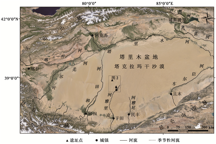
塔里木盆地地处我国西北干旱区,其周缘广泛分布着的绿洲(图 1),在历史上曾为连接东西方文明的重要地带[1]。据考古发掘与历史考据[2~5],这些绿洲曾几经兴衰,还有些古绿洲,遗弃或埋藏在沙漠深处[6~10]。关于绿洲演化的原因,观点各异。钱云[11]认为人类生产力的发展会使绿洲自下游向上游迁移;沈竟琪等[12]认为战争是导致绿洲沙化的重要原因;陈荷生[13]认为水文状况的变化是决定绿洲演化的重要因素;杨发相[14]认为地貌过程对绿洲的演化具有重要的影响;钟巍和熊黑钢[15]认为气候波动导致绿洲的演变;周兴佳等[16]、杨小平[17]、刘嘉麒和秦小光[18]则认为自然环境演变和人类活动在不同时期的耦合决定绿洲的性质和发展。而笔者认为,讨论绿洲演化的机理,须先选取相对连续的古绿洲序列进行,以往诸多分歧,或许缘于此类材料的缺少。近来,随着南疆克里雅河流域圆沙古城及其附近相关考古学[8, 19]、年代学[20]和人类学[21]等方面工作的开展,使这一地区成为探讨绿洲演化相关问题的理想场所,如中法克里雅河考古队首次发掘整理了古城及其附近的墓葬并测定了年龄,认为古城上限应不晚于西汉[8, 19];张峰等[20]通过地貌学、考古学的相关工作及年代测定,认为以圆沙古城遗址为中心并与之同时代的古绿洲至少在春秋时代就已经存在;高诗珠等[21]通过对圆沙古城15例古代居民的线粒体DNA(mtDNA)的研究,判定了圆沙古城古代人群归属于欧罗巴人种,与现代中亚南部人群、印度河流域人群以及新疆察吾呼古代人群间存在着相对较近的遗传距离。
|
图 1 塔里木盆地略图(Google Earth Image) Fig. 1 Overview of the Tarim Basin(Google Earth Image) |
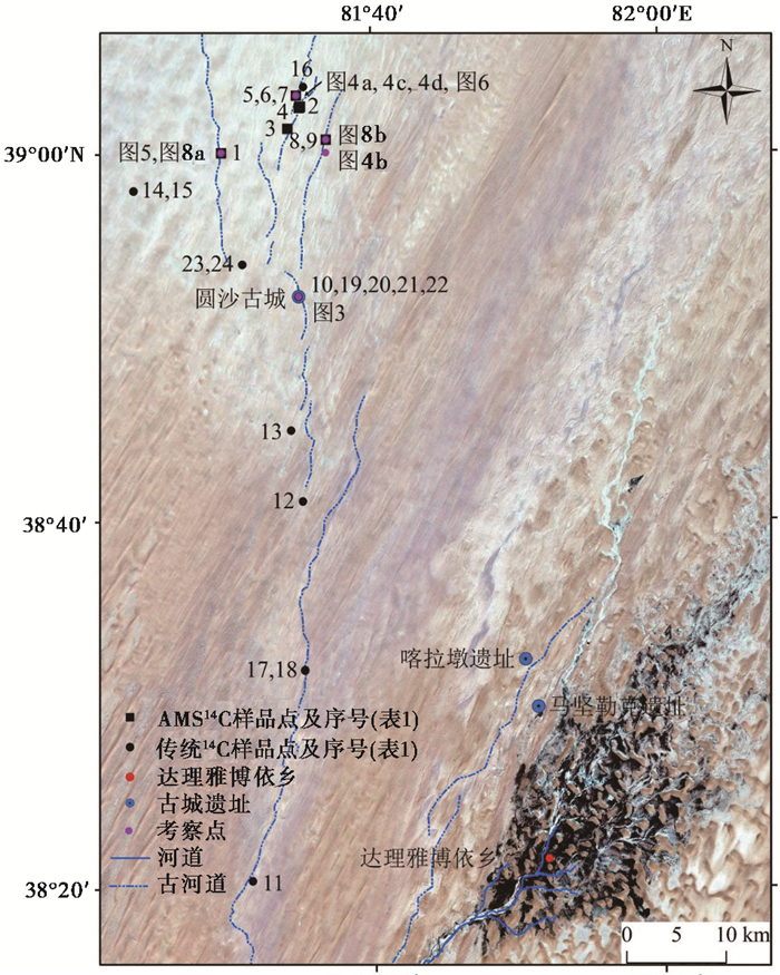
克里雅河是塔里木盆地南缘的主要河流之一,其下游不同位置曾先后于春秋战国至汉晋时期发育以圆沙古城[20]、喀拉墩遗址[8, 19]、马坚勒克遗址[22, 23]为中心的人居绿洲,它们时代基本连续,保留了丰富的有关环境演化的信息,其中尤以圆沙古城一带的古绿洲遗存相对独立且完整,但是由于被发现的较晚[8, 19],且位于沙漠腹地,交通不便,相关报道很少。已有的年代学数据多分布在圆沙古城附近[8]及其以南[20, 24](图 2),而对于绿洲演化研究具有重要意义的圆沙古城以北地区,数据少有覆盖。本文则针对这一地区做了考察,增测了相关年代学数据,结合前人相关数据探讨了古绿洲的古环境与年代学框架,同时对该地区争议颇多的“汉代丝绸之路扜弥古国地望”、“塔里木南河”等历史地理问题及相关古气候问题做出了进一步的认识。
|
图 2 研究区与采样点位置图(Landsat 7,RGB-732) Fig. 2 Location of investigation area and sample (Landsat 7, RGB-732) |
研究区位于塔克拉玛干沙漠腹地克里雅河现代尾闾一带(图 1)。该河发源于昆仑山主峰乌什腾格山北坡[25],自南向北流入沙漠腹地,并在其末端形成达理雅博依现代绿洲。
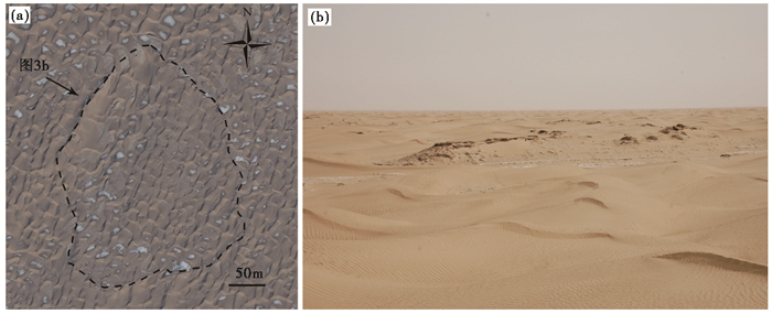
达理雅博依西,存有一处干三角洲[26],其上有大量古绿洲遗存(图 2)。其中喀拉墩遗址以汉代二层官署为代表,黄文弼[4]称之为“守望之所”。圆沙古城(38°52′N,81°35′E,见图 2和3)则位于喀拉墩遗址西北约40km处的另一处干三角洲上。因研究区处于沙漠腹地,基本无气象资料,但总体上对应于塔克拉玛干沙漠大陆性暖温带干旱气候[27]。地貌类型为一接受河流长期流散冲积,沉积而成的三角洲,在Landsat 7(RGB-732)影像中(图 2),这一区域颜色较周围沙漠稍浅。由于长期的风蚀、风积作用,这里沙漠化严重。地形总体比较平坦,现多被密集的新月形沙丘和沙丘链所覆盖[24];三角洲上残留有大量河漫滩遗存,可见干枯的胡杨、柽柳根以及古居民遗存等。圆沙古城遗址文化类型属铁器时代遗存[20];古居民为自帕米尔以西迁徙来的欧罗巴人种[21]。
2 材料与方法圆沙古城一带三角洲上古河道的年代学数据,尤其相对于传统14 C方法误差范围更窄的AMS 14 C年龄对认识古绿洲演化甚为重要。本文样品主要采自圆沙古城以北(图 2)。采集部位多分布在风蚀古河道两侧的古河漫滩,共采集胡杨、红柳枝条、动物粪便及木炭等AMS 14 C样品9个(图 2和表 1),均使用聚乙烯瓶包装并编号,送中国科学院西安环境研究所AMS 14 C实验室测定。为便于对比,用CALIB 6.01程序(http://calib.qub.ac.uk/calib),IntCal04数据库[28]对已发布的碳年龄数据[8, 24]进行了校正(表 1),后文中提到的这些碳年龄数据均为校正结果。
3 结果 3.1 古居民活动遗迹野外古居民活动遗迹多见于古河漫滩和古河床附近(图 2),反映古居民依水而生的生活方式,这与现代绿洲达理雅博依乡居民十分相似[29]。在圆沙古城北部的古河床附近捡到一套单耳带流黑陶罐和陶碗(图 2和图 4a),为古居民盛、煮水和食物的器皿,还捡到一器型完整的铁器(图 2和图 4c),锈蚀严重,直径约10cm,厚度约0.5cm,其用途尚不可知,但反映当时塔里木盆地古居民已具备铁器冶炼和打制技术;在圆沙古城东北部的古河床发现一件以胡杨整木取空掏制而成的器具(图 2和图 4b),应是用来取水的,其长约35cm,宽约10cm,可见当时胡杨枝干的粗大;古居民房屋遗址多位于河漫滩,因风蚀,房屋基部已基本被流沙覆盖(图 2和图 4d),其上可见散布的枯干胡杨枝干。
|
图 3 圆沙古城Bing卫星图(a)和西北部照片(b) Fig. 3 The overview of Yuansha site. (a)Bing Image of Yuansha site and (b)the photo in the northwest of Yuansha site |

|
图 4 圆沙古河道一带的古居民活动遗迹照片 (a)陶器(shards);(b)盛水器(water container);(c)铁器(ironware);(d)房屋遗址(house remnants) Fig. 4 Photos of settlement relics along the fossil/dry Keriya River channel |
在圆沙三角洲西北部见一风蚀古河道(图 2和图 5),谷深约6.5m,宽约400m,谷底分布流动沙丘;两岸则几乎被流沙覆盖,岸上沙丘高约1~2m,河漫滩部位清晰可见残存的枯死胡杨和芦苇根。样品110220-1w1为古河漫滩上残留的胡杨木,其14 C年龄为2046±36cal.a B.P.(表 1),即胡杨枯死的年龄距今约2ka左右,大约为西汉时期,而克里雅河古河道干涸的时间应略早于此时段。

|
图 5 古河道横断面示意图 Fig. 5 Fossil river valley cross-section |
| 表 1 圆沙三角洲碳年龄数据 Table 1 Dating and calibration results ofAMS 14 C and14 C in Yuansha delta |
样品110220w1、 110220w2和110220w3(图 2和表 1)为取自三角洲中部河漫滩上遗存的枯干胡杨木,端部均有古居民砍过痕迹,14 C年龄分别为2314±36cal.a B.P.、 2400±30cal.a B.P.和2333±45cal.a B.P.(表 1),说明此处曾约于战国时期发育河漫滩并有古人活动。
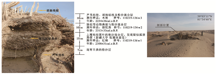
在圆沙古城北部一处河漫滩之上发现古居民房屋遗址(图 2和6),其大部已被流沙覆盖,基部出露枯干的红柳和胡杨枝干。遗址剖面可分为4层,上层为约10cm的胡杨枯枝与落叶及干枯的芦苇粉沙混合层;第二层为骆驼等动物粪便与粉沙混合层,厚度约为10cm;第三层以长短一致的红柳和胡杨枝条为基部,上面为混合有枯枝及落叶的粉沙混合层,较其上两层混合层厚,约15cm,应为人工修过的房屋构筑材料;最底部为约7cm的沙土混合层,里面混有动物粪便和胡杨、红柳枝条等。房屋基部的动物粪层在一定程度上说明当时生产活动中牧业已经占比较大的比重。样品110219-136w1、 110219-136w2和110219-136w3分别为取自该处的红柳枝条、骆驼粪便和木炭,其14 C年龄分别为2308±31cal.a B.P.、 2313±33cal.a B.P.和2234±36cal.a B.P.(表 1),均在约战国时期。古居民建筑房屋,取材以红柳和胡杨为主,这一现象与达理雅博依乡现代居民相同。说明在一定的生产力条件下,在相似的自然环境中,不同时代的人对生产和生活方式的选择具有趋同性。
|
图 6 圆沙古城北部古河道房屋遗址 Fig. 6 Residential remnant in the north of Yuansha site |
样品110215-14w和110215-4w1为取自圆沙古城北部(图 2)河漫滩同一剖面的胡杨枝条和羊粪,距表层约40cm,其14 C年龄分别为2235±50cal.a B.P.和2391±36cal.a B.P.(表 1),说明该地至少于战国时期发育且当时已有古代人类居住。
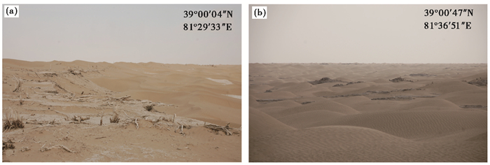
4 讨论 4.1 对圆沙古城一带三角洲发育年代的新认识与前人数据相比[8, 20, 24],本次圆沙古城及其北部样品测定结果在时间上更集中在战国(仅样品110220-1w1在西汉)(图 2、表 1和图 7)。观察已获得的圆沙三角洲碳年龄数据(表 1)发现:圆沙古城以北样品总体老于南部样品(它们多集中在东汉至魏晋南北朝,见图 7);中、东部样品集中分布在春秋战国,西北部则出现有较年轻的西汉-东汉时期样品(图 2、表 1和图 7)。野外所见古河道地貌风蚀程度亦与年代学数据相符,三角洲西北部古河道的西岸河床基本被流沙覆盖,但尚残存有古河岸痕迹,岸边可见枯死的红柳、线状连续分布的干死胡杨等(图 2和图 8a);三角洲东北部的古河道东岸,其上虽尚残存有枯干的植物枝干和河流沉积层(图 2和图 8b),但已不见古河岸踪迹,遍布1~2m的流动沙丘。

|
图 7
圆沙三角洲年代学样品年代
▲本文AMS 14 C结果(results of this study), ■前人14 C [8, 20, 24]数据(previously data) Fig. 7 14 C ages andAMS 14 C ages of Yuansha delta |
|
图 8 圆沙古城西北(a)与东北部(b)古河道照片 Fig. 8 The fossil river valley photo in the northwest(a) and northeast (b) of Yuansha site |
可见圆沙古城所依托的古绿洲主要是在战国时期发育(图 7),并占据了三角洲的大部分。之所以圆沙三角洲西或西北部和古河道干流上残存有西汉时期的枯干胡杨[20],且在圆沙古城西北700m处发现有公元前387年~公元56年的墓葬[8],是由于虽然此后约2.2~1.9ka克里雅河的东迁和喀拉墩一带古绿洲的兴起,但是通往当地的古河道仍然有水,并在一定程度上维系着当地的生态环境。而圆沙三角洲西部约1.9ka[20]的年轻碳年龄说明克里雅河河水回迁,但是由于流量较小,形成的古绿洲规模较小,仅覆盖了古河道干流及三角洲的西部,未能到达深远的沙漠腹地,也没有对战国时期形成的古河道造成干扰。
4.2 丝绸之路当道之国“扜弥地望”的讨论汉通西域,古籍记载西汉时期在克里雅河一带存在一个大国——扜弥,曾经盛极一时,是汉代丝路南道中人口最多的国家[30, 31]。关于扜弥古国的描述,最早见于《史记·大宛列传》,“大宛在匈奴西南,……东则扜罙、于窴”,另据《汉书·西域传》,“扜弥国,王治扜弥城,去长安九千二百八十里。户三千三百四十,口二万四十,胜兵三千五百四十人。辅国侯、左右将、左右都尉、左右骑君各一人,译长二人。东北至都护治所三千五百五十三里,南与渠勒、东北与龟兹(今库车)、西北与姑墨(今阿克苏)接,西通于阗(今和田一带)。今名宁弥。”
关于扜弥地望,《汉书·西域传》中所载扜弥古国“西通于阗(今和田一带)三百九十里”,另据《新唐书·地理志》记载“于阗东三百九十里,有建德力河(克里雅河)”,于阗历史时期在位置上没有发生大的改变,照此距离推算,扜弥应是临着克里雅河的。在环境条件相对干旱的沙地地区,水源作为重要的限制性因素,对人类活动的分布具有重要影响[32],或许正是因为濒临克里雅河,西汉时期扜弥古国给养人口才可达到两万四十。而在圆沙和喀拉墩一带的古绿洲遗存被发现后,学术界又提出了扜弥古国位于克里雅河尾闾的观点[8, 20, 31],目前几乎可以确定扜弥古国就位于克里雅河流域,而扜弥的主体又在流域的哪个部位呢?
在克里雅河流域发育的诸多绿洲遗存,圆沙古城所依托的古绿洲在西汉之前就衰落了[20],不太可能是扜弥古国所在。喀拉墩一带虽在西汉时期发育古绿洲,曾为汉代丝路南道[33],且连通至塔里木河,为塔里木盆地南北的重要枢纽[24],因此有学者[4]认为其是西汉扜弥故地。但喀拉墩古绿洲发育于河流尾闾三角洲,受河流摆动影响,稳定性差。且当时盆地南缘在历史时期环境已不甚好,《史记·大宛列传》指出,塔里木河下游地区“乏水草”,《汉书·西域传》记载“地沙卤,少田,寄田养谷旁国……乏水草”,在这种脆弱环境下,本来就不稳定的尾闾三角洲应该很难供养大规模的人口。即便尾闾三角洲是稳定的,据当代克里雅河尾闾三角洲达理雅博依乡政府统计的2011年当地人口数据,仅约为1400人,即如喀拉墩就是扜弥,在西汉时期尾闾绿洲也无法给养二万四十人口。而东汉时期克里雅河尾闾圆沙西部发育过与扜弥古国时间相一致的绿洲[20],其规模亦远小于与圆沙古城同期的古绿洲,当然也不应该成为扜弥绿洲主体。那么扜弥的都城必不在克里雅河的尾闾,应另有它处。而于田一带河流中游地区拥有充足的水量补给,存在发育条件良好的绿洲,当地的第四纪沉积物[16, 34]及考古学证据[35~37]亦显示其发育历史悠久,推测应为汉扜弥中心地所在。
另据《后汉书·西域传》记载“出玉门,经鄯善、且末、精绝三千余里至拘弥。拘弥国,居宁弥城,去长史所居柳中四千九百里,去洛阳万二千八百里。领户二千一百七十三,口七千二百五十一,胜兵千七百六十人……其国西接于阗三百九十里。”可见东汉时期,扜弥的地望与《汉书·西域传》中所载一致,其方位并没有发生明显变化。然而在人口数量上却与西汉时期扜弥国“户三千三百四十,口两万四十”相差甚远。之所以会出现如此大的差距,可能与当时的气候变化有关[38],也可能与当时中央政府在西域的管辖政策有关。西汉时期,中央政府强盛,为加强边疆统治,设置西域都护,推行“移民实边”、“兴办屯田”等政策,西域相对稳定。稳定的社会环境有利于盆地绿洲的发展和聚落的出现,随之邻近的城镇会连接、合并,对外统称一座大城[39]。西汉时期的扜弥在塔里木盆地南缘首屈一指,容易得到周边诸小国和城镇的臣服,所以当时人口达到两万四十也不足为奇;东汉时期,中央政府对西域的管理趋于疏松,西域诸国战乱纷争,据《后汉书·西域传》,扜弥古国曾和于阗等国家进行过多次战争,疆域可能减少,人口数量相对较少。
4.3 塔里木“南河”有关问题的讨论历史时期关于对塔里木盆地水系格局的记载,最早见《史记·大宛列传》,而后在《汉书·西域传》、《后汉书·西域传》等古籍中也有提及,但都较为简略,成书于北魏时期的《水经注》首次对塔里木河水系作了系统和全面的记述[40, 41]。该书中多处提及塔里木盆地的两条主要河流,“北河”和“南河”,北河被认为是今塔里木河,争议较少。
《水经注》对“南河”的记载:“河水自葱岭分源……南河又东径于阗国北……南河又东北径扜弥国北……南河又东径精绝国北……南河又东径且末国北,又东,右会阿耨达大水……且末河东北流径且未北,又流而左会南河,会流东逝,通为注滨河。注滨河又东径鄯善国北……其水东注泽,泽在楼兰国北扜泥城。”,“南河自于阗东于北三千里,至鄯善入牢兰海者也。”,“北河自岐沙东分南河”,“北河自疏勒径流南河之北”。
其所述“南河”,流径范围自葱岭至罗布泊,覆盖很广,而现代塔里木盆地水系并不存在一条东西走向的“南河”,是史料记载有误还是塔里木盆地水系在历史时期曾发生了巨大的变化?因此对于“南河”是否存在及其流径范围,学术界一直存在争论。
黄文弼[42]通过对塔里木盆地河流的实地考察发现在于阗、喀拉墩遗址附近存在东北方向的古河床,结合古籍考证认为8世纪中叶以前在塔克拉玛干沙漠腹地存在“南河”,流经扜弥国遗址喀拉墩北,汇克里雅河;王守春[43]则通过遥感解译和文献考证认为在塔里木盆地北缘存在“南河”,并分别对《水经注》中四处提到的“南河”做了探讨,虽然提出“南河”是对几个存在于不同时期河段的概括称谓,但也认为其中一段汇克里雅河后继续向东流去;后来樊自立等[40, 41]通过实地考察、遥感解译及文献考证等途径认为,现塔里木河南存在的阿合达利亚等干河道为18世纪以前的“南河”,是由老叶尔羌河和老和田河构成的,并认为克里雅河断流是造成“南河”消失的重要原因。
虽然由于历时较长,环境变化导致塔里木盆地内部不同时期古河道和绿洲国家地理位置的变迁、名字的变化,使得对“南河”存在与否考证起来非常困难,但《水经注》及各位学者对南河的争论均涉及扜弥国与克里雅河,可见查明扜弥国的位置及历史时期克里雅河尾闾的迁移应是认识“南河”的关键线索。《水经注》中提到“南河”东径扜弥国北,而无论扜弥在克里雅河流域的哪个部位(于田、喀拉墩、圆沙),在于田、喀拉墩、圆沙附近都应该能发现“南河”曾经存在的痕迹。
黄文弼[42]认为喀拉墩遗址附近存在的东北方向的古河床为“南河”,历史时期克里雅河确曾东北流向汇入塔里木河[44],成为连接扜弥和龟兹古国的捷径[31];王守春[43]据遥感影像判断,这些古河道多在克里雅河延伸方向,并没有一条自西向东大河穿过的痕迹;而我们在圆沙古城一带的研究区也未发现有这样一条古河道穿过的痕迹(图 2)。由于克里雅河的主要补给来源是冰雪融水[45],并且在沙漠地区经常会由于补给不足而造成断流或来回摆动,所以即便是其曾汇入塔里木河,也是季节性河流或洪水的流入,形成不了一条稳定的大河。按现在径流量计算,克里雅河为和田河的1/6左右,叶尔羌河的1/10左右[46, 47],且克里雅河下游段为季节性河流,即便注入有关学者[40, 41]所认为的老叶尔羌河和老和田河构成的“南河”,其径流量的影响已经很小,很难谈到造成“南河”所谓的消失。历史时期在塔里木盆地紧靠于阗、扜弥、精绝国北,应该不存在一条与“北河”(塔里木河)完全平行的大河,所谓的“南河”或许并不存在[48]。
4.4 绿洲的发育与气候条件与圆沙古城同期的绿洲发育期间,盆地已从距今4ka左右的青铜时代进入铁器时代,虽然掌握金属工具的古居民改造自然的能力开始增加[49],但程度依然有限,绿洲的演化主要受自然条件变化的影响。干旱区,水资源决定着绿洲的分布与范围[10],沙漠腹地降水稀少[50],绿洲的兴废更是依赖于河流的稳定性和径流的补给情况[51]。作为绿洲聚落中心的圆沙古城比现代尾闾达理雅博依更深入沙漠约40~60km(图 1),说明当时克里雅河水量颇丰。考虑到克里雅河径流主要来源于高山冰雪融水补给[45],圆沙时期绿洲的发育应该与当时气温的升高有关。而这一时期前后塔里木盆地气候是如何变化的呢?据稍晚的《汉书·西域传》记载:“自且末以往,皆种五谷,土地草木,畜产作兵,略与汉同”。西汉内地所种五谷在盆地南缘也可种植,这似乎与有关盆地南缘气温升高的观点吻合[52]。然而历史记载毕竟零散,所代表气候状况的时间尺度亦有限。近年来虽有大量关于西部地区环境演变的沉积物[53~65]、冰芯[66, 67]、黄土[68~71]、孢粉[72~76]的报道,但分布于塔里木盆地周围且与圆沙古城同期发育绿洲相对应的记录并不多[77~80]。第四纪以来,盆地内部总体上应该是持续干旱的[81]。但沙漠腹地圆沙古绿洲的形成或许恰恰反映了Yang等[82]所提出的盆地的变湿;虽然这种变化在盆地内部可能并不太明显,但对河流上游山区而言,因高温引起降水的增加也会使河流径流量变大[83, 84]而导致下游绿洲的发育。这与陈发虎等[53]所提出中晚全新世亚洲季风衰落时内陆干旱区变得更湿润较为一致。总之,战国时期除圆沙古城外,塔里木盆地其他区域的城邦小国也逐渐发展[85],为一绿洲繁盛时期。
5 结论对圆沙古城所在三角洲以北的区域做了考察,发现遗迹点多处,采集测定了具有人类活动痕迹的AMS 14 C年龄样品9件,测定结果为2046±36cal.a B.P.至2400±30cal.a B.P.,与圆沙古城同期的古绿洲应主要发育于战国时期。结合前人工作发现,圆沙古城及其北部样品年代,多集中在春秋战国至西汉;老于其南部的东汉至魏晋南北朝样品;而三角洲中、东部样品年代较老,集中分布在春秋战国;西部或西北部样品年代较年轻,多在西汉-东汉时期。这与该时期克里雅河自西向东的摆动和总体南撤的趋势相符。结合遥感影像、遗址文物、文献记载和已有工作认为,“西域三十六国”之一的“扜弥”古国虽在圆沙、喀拉墩等地区均留有遗存痕迹,其主体部分应位于克里雅河尾闾上游的于田绿洲一带。历史时期在克里雅河尾闾达理雅博依与现代塔里木河间应不存在一条自西至东的大河,《水经注》所载“东径扜弥国北”的塔里木“南河”是否存在,仍需商榷。
致谢: 匿名审稿人提出了宝贵意见,杨美芳编辑提供了修改建议,特此致谢!
| 1 |
朱震达.
塔克拉玛干沙漠风沙地貌研究 . 北京: 科学出版社, 1981 : 3 ~26.
Zhu Zhenda. Study on the Geomorphology on Wind-drift Sands in the Taklamakan Desert. Beijing: Science Press, 1981 : 3 ~26. (  0) 0)
|
| 2 |
王炳华. 从考古资料看塔克拉玛干沙漠环境变迁.
新疆文物,1996 (4) : 95~102.
Wang Binghua. A study of the environmental change of the Taklamakan Desert from archaeological material. Xinjiang Cultural Relics,1996 (4) : 95~102. (  0) 0)
|
| 3 |
王炳华. .
丝绸之路考古研究,1993 : 1~57.
Wang Binghua. . Archaeological Research on the Silk Road,1993 : 1~57. (  0) 0)
|
| 4 |
黄文弼.
塔里木盆地考古记 . 北京: 科学出版社, 1958 : 42 ~62.
Huang Wenbi. Archaeological Records in the Tarim Basin. Beijing: Science Press, 1958 : 42 ~62. (  0) 0)
|
| 5 |
张玉忠. 新疆考古述略.
考古,2002 (6) : 3~13.
Zhang Yuzhong. A brief review of Xinjiang archaeology. Archaeology,2002 (6) : 3~13. (  0) 0)
|
| 6 |
李吟屏. 和田地区沙漠与绿洲的变迁——从文字史料与考古资料得到的启示.
新疆大学学报(哲学社会科学版),1985 (3) : 70~80.
Li Yinping. Evolution of deserts and oases in the Hotan region. Journal of Xinjiang University (Philosophy and Social Science Edition),1985 (3) : 70~80. (  0) 0)
|
| 7 |
中国新疆文物考古研究所, 日本佛教大学尼雅遗址学术研究机构.
丹丹乌里克遗址——中日共同考察研究报告 . 北京: 文物出版社, 2009 : 32 ~50.
Xinjiang Institute of Cultural Relics and Archaeology, Niya Ruins Academic and Research Institutions of Bukkyo University. The Research Report of the Dandanwulik Ruins Done by Institutions from Both China and Japan. Beijing: Cultural Relics Publishing House, 2009 : 32 ~50. (  0) 0)
|
| 8 |
新疆文物考古研究所, 法国科学研究中心315所. 新疆克里雅河流域考古调查概述.
考古,1998 (12) : 28~37.
Xinjiang Institute of Cultural Relics and Archaeology, The 315 Institute of French National Center for Scientific Research. Summaries of the archaeological investigation along the Keriya River in Xinjiang. Archaeology,1998 (12) : 28~37. (  0) 0)
|
| 9 |
中日/日中共同尼雅遗迹学术考察队.中日/日中共同尼雅遗迹学术调查报告书.京都:法藏馆, 1996. 35~175
Niya Ruins Academic Research Teams of Both China and Japan. The Academic Investigation Report of Niya Ruins Done by Both China and Japan. Kyoto:Hozokan, 1996. 35~175 (  0) 0)
|
| 10 |
樊自立. 塔里木盆地绿洲形成与演变.
地理学报,1993, 48 (5) : 421~427.
Fan Zili. A study on the formation and evolution of oases in Tarim Basin. Acta Geographica Sinica,1993, 48 (5) : 421~427. (  0) 0)
|
| 11 |
钱云. 历史时期新疆绿洲的演变和发展.
干旱区资源与环境,1997, 11 (2) : 37~47.
Qian Yun. Historical changes of Xinjiang oases. Journal of Arid Land Resources and Environment,1997, 11 (2) : 37~47. (  0) 0)
|
| 12 |
沈竟琪, 高前兆, 胡智育. 塔里木盆地南部历史时期沙漠化的初步研究.
中国沙漠,1982, 2 (1) : 21~28.
Shen Jingqi, Gao Qianzhao, Hu Zhiyu. Preliminary study on desertification in the southern area of Tarim Basin in the historical period. Journal of Desert Research,1982, 2 (1) : 21~28. (  0) 0)
|
| 13 |
陈荷生. 水在克里雅河流域生态地理环境中的作用.
中国沙漠,1988, 8 (2) : 38~53.
Chen Hesheng. Effect of water in eco-geographic environment of the Keriya River valley. Journal of Desert Research,1988, 8 (2) : 38~53. (  0) 0)
|
| 14 |
杨发相. 塔里木盆地地貌过程对绿洲形成演变的影响.
干旱区地理,2003, 26 (4) : 361~366.
Yang Faxiang. Influence of geomorphologic processes on formation and evolution of the oases in the Tarim Basin, Xinjiang. Arid Land Geography,2003, 26 (4) : 361~366. (  0) 0)
|
| 15 |
钟巍, 熊黑钢. 塔里木盆地南缘4ka B.P.以来气候环境演化与古城镇废弃事件关系研究.
中国沙漠,1999, 19 (4) : 343~347.
Zhong Wei, Xiong Heigang. Paleo-climatic and environmental development since about 4ka B.P. and the relation with abandonments of ancient cities in Southern Xinjiang. Journal of Desert Research,1999, 19 (4) : 343~347. (  0) 0)
|
| 16 |
周兴佳, 李保生, 朱峰, 等. 南疆克里雅河绿洲发育和演化过程研究.
云南地理环境研究,1996, 8 (2) : 44~57.
Zhou Xingjia, Li Baosheng, Zhu Feng, et al. The research on the development and evolution of the oasis of Keriya River in the Tarim Basin of Xinjiang. Yunnan Geographic Environment Research,1996, 8 (2) : 44~57. (  0) 0)
|
| 17 |
杨小平. 绿洲演化与自然和人为因素的关系初探——以克里雅河下游地区为例.
地学前缘,2001, 8 (1) : 83~89.
Yang Xiaoping. The relationship between oases evolution and natural as well as human factors——Evidences from the lower reaches of the Keriya River, Southern Xinjiang, China. Earth Science Frontiers,2001, 8 (1) : 83~89. (  0) 0)
|
| 18 |
刘嘉麒, 秦小光. 塔里木盆地的环境格局与绿洲演化.
第四纪研究,2005, 25 (5) : 533~539.
Liu Jiaqi, Qin Xiaoguang. Evolution of the environmental framework and oasis in the Tarim Basin. Quaternary Sciences,2005, 25 (5) : 533~539. (  0) 0)
|
| 19 |
伊弟利斯·阿不都热苏勒, 张玉忠. 1993年以来新疆克里雅河流域考古述略.
西域研究,1997 (3) : 39~42.
Idriss·Abdurusul, Zhang Yuzhong. A brief review of the archaeology along the Keriya River since 1993 in Xinjiang. The Western Regions Studies,1997 (3) : 39~42. (  0) 0)
|
| 20 |
张峰, 王涛, 海米提·依米提, 等. 2.7~1.6ka B.P.塔克拉玛干沙漠腹地克里雅河尾闾绿洲的变迁.
中国科学:地球科学,2011, 54 (12) : 1971~1980.
Zhang Feng, Wang Tao, Hamid·Yimit, et al. Hydrological changes and settlement migrations in the Keriya River delta in central Tarim Basin ca.2.7~1.6ka B.P.:Inferred from 14C and OSL chronology. Science China:Earth Sciences,2011, 54 (12) : 1971~1980. doi:10.1007/s11430-011-4206-1 (  0) 0)
|
| 21 |
高诗珠, 崔银秋, 杨亦代, 等. 新疆克里雅河下游圆沙古城古代居民线粒体DNA多态性研究.
中国科学(C辑),2008, 51 (3) : 205~213.
Gao Shizhu, Cui Yinqiu, Yang Yidai, et al. Mitochondrial DNA analysis of human remains from the Yuansha Site in Xinjiang, China. Science in China(Series C),2008, 51 (3) : 205~213. (  0) 0)
|
| 22 |
李吟屏. 克里雅河末端古遗址踏察简记及其有关问题.
新疆文物,1991 (1) : 54~58.
Li Yinping. Investigation report of the ruins and the related problems of the Keriya River delta. Xinjiang Cultural Relics,1991 (1) : 54~58. (  0) 0)
|
| 23 |
中国科学院塔克拉玛干沙漠综合科学考察队考古组. 于田县马坚勒克遗址调查简报.
新疆文物,1991 (1) : 8~13.
Archaeology Group, Taklamakan Desert Scientific Expedition Team, Chinese Academy of Sciences. A brief report of the investigation at Namajanlik in Yutian County. Xinjiang Cultural Relics,1991 (1) : 8~13. (  0) 0)
|
| 24 |
周兴佳.克里雅河曾流入塔里木河的考证.见:新疆克里雅河及塔克拉玛干科学考察队编.克里雅河及塔里拉玛干科学探险考察报告.北京:中国科学技术出版社, 1991.
Zhou Xingjia. Textual research on the matter of the Keriya River flowed into the Tarim River. In:Xinjiang Keriya River and the Taklamakan Desert Scientific Expedition Team ed. The Report of Scientific Exploration and Investigation in the Keriya River Valley and the Taklamakan Desert. Beijing:China Science and Technology Publishing House, 1991. 40~46 (  0) 0)
|
| 25 |
周兴佳, 朱峰, 李世全. 克里雅河绿洲的形成与演变.
第四纪研究,1994 (3) : 249~255.
Zhou Xingjia, Zhu Feng, Li Shiquan. The formation and evolution of oasis in the Keriya River valley. Quaternary Sciences,1994 (3) : 249~255. (  0) 0)
|
| 26 |
朱震达, 陆锦华, 江伟铮. 塔克拉玛干沙漠克里雅河下游地区风沙地貌的形成发育与环境变化趋势的初步研究.
中国沙漠,1988, 8 (2) : 1~10.
Zhu Zhenda, Lu Jinhua, Jiang Weizheng. Study on formation and development of aeolian landform and trend of environmental change at lower reach of the Keriya River, Taklimakan Desert. Journal of Desert Research,1988, 8 (2) : 1~10. (  0) 0)
|
| 27 |
凌裕泉. 塔克拉玛干沙漠的气候特征及其变化趋势.
中国沙漠,1990, 10 (2) : 9~19.
Ling Yuquan. The climatic characteristics and its changing tendency in the Taklimakan Desert. Journal of Desert Research,1990, 10 (2) : 9~19. (  0) 0)
|
| 28 |
Reimer P J, Baillie M G L, Bard E, et al. IntCal04 terrestrial radiocarbon age calibration, 0~26cal kyr B.P.
Radiocarbon,2004, 46 (3) : 1029~1058.
doi:10.1017/S0033822200032999 ( 0) 0)
|
| 29 |
Yang Xiaoping, Zhu Zhenda, Jaekel D, et al. Late Quaternary palaeoenvironment change and landscape evolution along the Keriya River, Xinjiang, China:The relationship between high mountain glaciation and landscape evolution in foreland desert regions.
Quaternary International,2002 : 97~166.
( 0) 0)
|
| 30 |
殷晴. 和田地区的环境演变与生态经济研究.
新疆社会科学,1987 (3) : 49~55.
Yin Qing. The research on the environmental evolution and ecological economy in the Hotan area. Social Sciences in Xinjiang,1987 (3) : 49~55. (  0) 0)
|
| 31 |
殷晴. 和田水系变动和绿洲兴衰的历史考察——兼述穿越塔克拉玛干沙漠的两条南北通道.
新疆社会科学,1987 (5) : 79~91.
Yin Qing. Historical investigation of the Hotan stream systems and oasis evolution and the account of the two main roads through the south and north of the Taklamakan Desert. Social Sciences in Xinjiang,1987 (5) : 79~91. (  0) 0)
|
| 32 |
卓海昕, 鹿化煜, 贾鑫, 等. 全新世中国北方沙地人类活动与气候变化关系的初步研究.
第四纪研究,2013, 33 (2) : 303~313.
Zhuo Haixin, Lu Huayu, Jia Xin, et al. A preliminary study on human activities in sand fields of Northern China and its relationship with the climatic variations in Holocene. Quaternary Sciences,2013, 33 (2) : 303~313. (  0) 0)
|
| 33 |
樊自立, 张青青, 徐海量. 塔克拉玛干沙漠中的古代交通路线.
中国沙漠,2009, 29 (5) : 815~819.
Fan Zili, Zhang Qingqing, Xu Hailiang. The ancient traffic routes in the Taklamakan Desert. Journal of Desert Research,2009, 29 (5) : 815~819. (  0) 0)
|
| 34 |
杨逸畴. 克里雅河地貌的形成与演化.
干旱区地理,1990, 13 (1) : 37~45.
Yang Yichou. Formation and evolution on Keriya River landforms. Arid Land Geography,1990, 13 (1) : 37~45. (  0) 0)
|
| 35 |
中国社会科学院考古研究所新疆队. 新疆和田地区策勒县达玛沟佛寺遗址发掘报告.
考古学报,2007 (4) : 489~525.
Xinjiang Archaeology Group, Institute of Archaeology, Chinese Academy of Social Sciences. Excavations of Buddhist temple sites at Damagou in Qira County of Hetian prefecture, Xinjiang. Acta Archaeologica Sinica,2007 (4) : 489~525. (  0) 0)
|
| 36 |
巫新华. 新疆和田达玛沟佛寺考古新发现与研究.
文物,2009 (8) : 55~68.
Wu Xinhua. New discovery and research of Buddhist temples in Damagou Villae, Xinjiang. Cultural Relics,2009 (8) : 55~68. (  0) 0)
|
| 37 |
中国社会科学院考古研究所新疆队. 新疆策勒县达玛沟3号佛寺建筑遗址发掘简报.
考古,2012 (10) : 15~24.
Xinjiang Archaeology Group, Institute of Archaeology, Chinese Academy of Social Sciences. The excavation presentation of No.3 Buddhist temple architectural sites at Damagou Village in Qira County, Xinjiang. Archaeology,2012 (10) : 15~24. (  0) 0)
|
| 38 |
竺可桢. 中国近五千年来气候变迁的初步研究.
中国科学,1973, 3 (2) : 168~189.
Chu Kochen. A preliminary study on climate change over nearly five thousand years in China. Science in China,1973, 3 (2) : 168~189. (  0) 0)
|
| 39 |
殷晴. 湮埋在沙漠中的绿洲古国——扜弥故地考索.
新疆社会科学,1985 (1) : 65~79.
Yin Qing. The Wumi, a kingdom buried under the desert sands:A study on its location. Social Sciences in Xinjiang,1985 (1) : 65~79. (  0) 0)
|
| 40 |
樊自立. 历史时期塔里木河流域水系变迁的初步研究.
新疆地理,1979 (2) : 20~36.
Fan Zili. Preliminary study on the evolution of the stream systems in the Tarim River basin in history. Xinjiang Geography,1979 (2) : 20~36. (  0) 0)
|
| 41 |
樊自立, 陈亚宁, 王亚俊. 新疆塔里木河及其河道变迁研究.
干旱区研究,2006, 23 (1) : 8~15.
Fan Zili, Chen Yaning, Wang Yajun. Study on the Tarim River and its watercourse evolution in Xinjiang:Recorded in the "Records of Rovers". Arid Zone Research,2006, 23 (1) : 8~15. (  0) 0)
|
| 42 |
黄文弼.
西北史地论丛 . 上海: 上海人民出版社, 1981 : 10 ~22.
Huang Wenbi. Collected Works about Paleogeography in Northwest China. Shanghai: Shanghai People's Publishing House, 1981 : 10 ~22. (  0) 0)
|
| 43 |
王守春. 《水经注》塔里木盆地"南河"考辩.
地理研究,1987, 6 (4) : 36~44.
Wang Shouchun. Textual research on the "South River" of Tarim Basin recorded by "Shuijing Zhu". Geographical Research,1987, 6 (4) : 36~44. (  0) 0)
|
| 44 |
Yang X. The oases along the Keriya River in the Taklamakan Desert, China, and their evolution since end of the Last Glaciation.
Environmental Geology,2001, 41 : 314~320.
doi:10.1007/s002540100388 ( 0) 0)
|
| 45 |
周绍起.克里雅河水文初步分析.见:新疆克里雅河及塔克拉玛干科学考察队编.克里雅河及塔里拉玛干科学探险考察报告.北京:中国科学技术出版社, 1991. 117~125
Zhou Shaoqi. A preliminary hydrological analysis of the Keriya River. In:Xinjiang Keriya River and the Taklamakan Desert Scientific Expedition Team ed. The Report of Scientific Exploration and Investigation in the Keriya River Valley and the Taklamakan Desert. Beijing:China Science and Technology Publishing House, 1991. 117~125 (  0) 0)
|
| 46 |
凌红波, 徐海量, 张青青, 等. 新疆塔里木河三源流径流量变化趋势分析.
地理科学,2011, 31 (6) : 728~733.
Ling Hongbo, Xu Hailiang, Zhang Qingqing, et al. The annual runoff variation trends in the three headstreams of Tarim River. Scientia Geographica Sinica,2011, 31 (6) : 728~733. (  0) 0)
|
| 47 |
凌红波, 徐海量, 张青青. 新疆克里雅河源流区径流变化与气候因子关系的非线性分析.
地理研究,2012, 31 (5) : 792~802.
Ling Hongbo, Xu Hailiang, Zhang Qingqing. Nonlinear analysis of runoff change and climate factors in the headstream of Keriya River, Xinjiang. Geographical Research,2012, 31 (5) : 792~802. (  0) 0)
|
| 48 |
王北辰. 古代西域南道上的若干历史地理问题.
地理研究,1983, 2 (3) : 30~43.
Wang Beichen. Several problems about historical geography in the southern road of ancient "Shi-Yu". Geographical Research,1983, 2 (3) : 30~43. (  0) 0)
|
| 49 |
熊黑钢, 钟巍, 塔西甫拉提, 等. 塔里木盆地南缘自然与人文历史变迁的藕合关系.
地理学报,2000, 55 (2) : 191~199.
Xiong Heigang, Zhong Wei, Tashpolat·Tiyip, et al. The coupling relationship between the nature and the man in south edge of Tarim Basin. Acta Geographica Sinica,2000, 55 (2) : 191~199. (  0) 0)
|
| 50 |
杨佐涛, 陈渭南, 陈广庭, 等. 塔克拉玛干沙漠腹地的气候表现.
中国沙漠,1995, 15 (3) : 293~298.
Yang Zuotao, Chen Weinan, Chen Guangting, et al. Characteristics of the weather in the hinterland of the Taklimakan Desert. Journal of Desert Research,1995, 15 (3) : 293~298. (  0) 0)
|
| 51 |
黄盛璋. .
绿洲研究,2003 : 40~73.
Huang Shengzhang. . Oasis Studies,2003 : 40~73. (  0) 0)
|
| 52 |
舒强, 钟巍, 熊黑钢, 等. 南疆尼雅地区4000a来的地化元素分布特征与古气候环境演化的初步研究.
中国沙漠,2001, 21 (1) : 12~18.
Shu Qiang, Zhong Wei, Xiong Heigang, et al. Study on the characters of the geochemical elements and changes of paleoclimate since about 4000a B.P. in Niya section. Journal of Desert Research,2001, 21 (1) : 12~18. (  0) 0)
|
| 53 |
Chen Fahu, Huang Xiaozhong, Yang Meilin, 等. Westerly dominated Holocene climate model in arid Central Asia——Case study on Bosten Lake, Xinjiang, China.
Quaternary Sciences,2006, 26 (6) : 881~887.
( 0) 0)
|
| 54 |
汪海燕, 岳乐平, 李建星, 等. 全新世以来巴里坤湖面积变化及气候环境记录.
沉积学报,2014, 32 (1) : 93~100.
Wang Haiyan, Yue Leping, Li Jianxing, et al. Changing of the lake area and records of climate and environment of Barkol Lake during Holocene. Acta Sedimentologica Sinica,2014, 32 (1) : 93~100. (  0) 0)
|
| 55 |
刘宇航, 夏敦胜, 周爱锋, 等. 乌伦古湖全新世气候变化的环境磁学记录.
第四纪研究,2012, 32 (4) : 803~811.
Liu Yuhang, Xia Dunsheng, Zhou Aifeng, et al. Holocene environmental change recorded by magnetic properties of Wulungu Lake sediment. Quaternary Sciences,2012, 32 (4) : 803~811. (  0) 0)
|
| 56 |
孙博亚, 岳乐平, 赖忠平, 等. 14ka B.P.以来巴里坤湖区有机碳同位素记录及古气候变化研究.
第四纪研究,2014, 34 (2) : 418~424.
Sun Boya, Yue Leping, Lai Zhongping, et al. Paleoclimate change recorded by sediment organic carbon isotopes of Lake Barkol since 14ka B.P. Quaternary Sciences,2014, 34 (2) : 418~424. (  0) 0)
|
| 57 |
任雅琴, 王彩红, 李瑞博, 等. 有机质饱和烃和δ13Corg.记录的博斯腾湖早全新世晚期以来生态环境演变.
第四纪研究,2014, 34 (2) : 425~433.
Ren Yaqin, Wang Caihong, Li Ruibo, et al. Ecological environment change recorded by sediment n-alkane and δ13Corg. of Lake Bosten since late of Early Holocene. Quaternary Sciences,2014, 34 (2) : 425~433. (  0) 0)
|
| 58 |
王富葆, 马春梅, 夏训诚, 等. 罗布泊地区自然环境演变及其对全球变化的响应.
第四纪研究,2008, 28 (1) : 150~153.
Wang Fubao, Ma Chunmei, Xia Xuncheng, et al. Environmental evolution in Lop Nur since Late Pleistocene and its response to the global changes. Quaternary Sciences,2008, 28 (1) : 150~153. (  0) 0)
|
| 59 |
杨东, 罗超, 彭子成, 等. 新疆罗布泊地区32. 0~9. 1ka B.P.期间的孢粉记录及其古气候古环境演化.
第四纪研究,2009, 29 (4) : 755~766.
Yang Dong, Luo Chao, Peng Zicheng, et al. A pollen record and the paleoclimatic and environmental evolution in Lop-Nur, Xinjiang in 32.0~9.1ka B.P. Quaternary Sciences,2009, 29 (4) : 755~766. (  0) 0)
|
| 60 |
常秋芳, 常宏. 罗布泊Ls2孔近7.1Ma以来沉积物的环境磁学研究.
第四纪研究,2013, 33 (5) : 876~888.
Chang Qiufang, Chang Hong. The environmental magnetism study of core Ls2 in Lop-Nur, Tarim since 7.1Ma. Quaternary Sciences,2013, 33 (5) : 876~888. (  0) 0)
|
| 61 |
罗超, 杨东, 彭子成, 等. 新疆罗布泊地区近3.2万年沉积物的气候环境记录.
第四纪研究,2007, 27 (1) : 114~121.
Luo Chao, Yang Dong, Peng Zicheng, et al. Climatic and environmental records in the sediment of the Luobei Billabong in Lop-Nur, Xinjiang in recent 32ka. Quaternary Sciences,2007, 27 (1) : 114~121. (  0) 0)
|
| 62 |
薛积彬, 钟巍. 新疆巴里坤湖全新世环境记录及区域对比研究.
第四纪研究,2008, 28 (4) : 610~620.
Xue Jibin, Zhong Wei. Holocene climate change recorded by lacustrine sediments in Barkol Lake and its regional comparison. Quaternary Sciences,2008, 28 (4) : 610~620. (  0) 0)
|
| 63 |
杨保, 施雅风. 中国西北地区暖湿气候的地质记录及成因探讨.
第四纪研究,2003, 23 (1) : 60~68.
Yang Bao, Shi Yafeng. Warm-humid climate in Northwest China during the period of 40~30ka B.P.:Geological records and origin. Quaternary Sciences,2003, 23 (1) : 60~68. (  0) 0)
|
| 64 |
Jiang Qingfeng, Ji Junfeng, Shen Ji, et al. Holocene vegetational and climatic variation in westerly-dominated areas of Central Asia inferred from the Sayram Lake in Northern Xinjiang, China.
Science China:Earth Sciences,2013, 56 (3) : 339~353.
doi:10.1007/s11430-012-4550-9 ( 0) 0)
|
| 65 |
Feng Xiaohua, Yan Shun, Ni Jian, et al. Environmental changes and lake level fluctuation recorded by lakes on the plain in Northern Xinjiang during the Late Holocene.
Chinese Science Bulletin,2006, 51 (Suppl.1) : 60~67.
( 0) 0)
|
| 66 |
陈吉阳. 天山天格尔第二峰地区全新世中后期冰川变化的初步研究.
冰川冻土,1987, 9 (4) : 347~356.
Chen Jiyang. Preliminary research on the Mid-and Late-Holocene glacial fluctuations in Tianger Peak Ⅱregions, Tianshan Mountains. Journal of Glaciology and Geocryology,1987, 9 (4) : 347~356. (  0) 0)
|
| 67 |
姚檀栋. 古里雅冰芯近2000年来气候环境变化记录.
第四纪研究,1997 (1) : 52~61.
Yao Tandong. Climatic and environmental record in the past about 2000 years from the Guliya ice core. Quaternary Sciences,1997 (1) : 52~61. (  0) 0)
|
| 68 |
李冠华, 夏敦胜, 温仰磊, 等. 天山北麓典型黄土沉积序列的磁学特征及主控因子初探.
第四纪研究,2013, 33 (5) : 900~910.
Li Guanhua, Xia Dunsheng, Wen Yanglei, et al. Rock magnetism of the loess/paleosol sequences in north of the Tianshan Mountains, Northwest China. Quaternary Sciences,2013, 33 (5) : 900~910. (  0) 0)
|
| 69 |
夏敦胜, 陈发虎, 马剑英, 等. 新疆伊犁地区典型黄土磁学特征及其环境意义初探.
第四纪研究,2010, 30 (5) : 902~910.
Xia Dunsheng, Chen Fahu, Ma Jianying, et al. Magnetic characteristics of loess in the Ili area and their environmental implication. Quaternary Sciences,2010, 30 (5) : 902~910. (  0) 0)
|
| 70 |
李保生, 温小浩, ZhangDavid Dian, 等. 昆仑山北麓阿羌黄土剖面AQS3层段记录的末次间冰阶千年尺度的气候波动.
第四纪研究,2008, 28 (1) : 140~149.
Li Baosheng, Wen Xiaohao, Zhang David Dian, et al. Millennial-scale climate fluctuations during the last interstadial recorded in the AQS3 segment of the Aqiang loess section in the north piedmont of the Kunlun Mountains. Quaternary Sciences,2008, 28 (1) : 140~149. (  0) 0)
|
| 71 |
曾蒙秀, 宋友桂. 西风区昭苏黄土剖面中碳酸盐矿物组成及其古环境意义辨识.
第四纪研究,2013, 33 (3) : 424~436.
Zeng Mengxiu, Song Yougui. Carbonate minerals of Zhaosu loess section in westerly area and their paleoenvironmental significance. Quaternary Sciences,2013, 33 (3) : 424~436. (  0) 0)
|
| 72 |
陶士臣, 安成邦, 赵家驹, 等. 新疆东部托勒库勒湖流域表土花粉初步分析.
第四纪研究,2013, 33 (3) : 545~553.
Tao Shichen, An Chengbang, Zhao Jiaju, et al. The preliminary study of the surface pollen from Tuolekule Lake basin, eastern Xinjiang, China. Quaternary Sciences,2013, 33 (3) : 545~553. (  0) 0)
|
| 73 |
白友良, 蒋汉朝, 陈剑杰, 等. 新疆孔雀河北缘中更新世湖相沉积物的孢粉植物群初步研究.
第四纪研究,2013, 33 (5) : 856~865.
Bai Youliang, Jiang Hanchao, Chen Jianjie, et al. Preliminary study on the palynoflora from the Mid-Pleistocene lake sediments in the northern margin of the Peacock River, Xinjiang Province. Quaternary Sciences,2013, 33 (5) : 856~865. (  0) 0)
|
| 74 |
赵凯华, 杨振京, 张芸, 等. 新疆艾丁湖区中全新世以来孢粉记录与古环境.
第四纪研究,2013, 33 (3) : 526~535.
Zhao Kaihua, Yang Zhenjing, Zhang Yun, et al. Pollen records and paleoenvironment since Mid-Holocene in the Aydingkol Lake of Xinjiang. Quaternary Sciences,2013, 33 (3) : 526~535. (  0) 0)
|
| 75 |
姚轶锋, 王霞, 谢淦, 等. 孢粉记录的新疆地区新近纪植被格局与气候环境演化.
第四纪研究,2015, 35 (3) : 683~697.
Yao Yifeng, Wang Xia, Xie Gan, et al. Neogene vegetation pattern, climate and environment evolution in Xinjiang region:A synthesis of pollen records. Quaternary Sciences,2015, 35 (3) : 683~697. (  0) 0)
|
| 76 |
冯晓华, 阎顺, 倪健. 基于孢粉的新疆全新世植被重建.
第四纪研究,2012, 32 (2) : 304~317.
Feng Xiaohua, Yan Shun, Ni Jian. Pollen-based reconstruction of vegetation in Xinjiang during the Holocene. Quaternary Sciences,2012, 32 (2) : 304~317. (  0) 0)
|
| 77 |
Chen Fahu, Huang Xiaozhong, Zhang Jiawu, et al. Humid Little Ice Age in arid Central Asia documented by Bosten Lake, Xinjiang, China.
Science in China(Series D),2006, 49 (12) : 1280~1290.
doi:10.1007/s11430-006-2027-4 ( 0) 0)
|
| 78 |
Feng Z D, An C B, Wang H B. Holocene climatic and environmental changes in the arid and semi-arid areas of China:A review.
The Holocene,2006, 16 (1) : 119~130.
doi:10.1191/0959683606hl912xx ( 0) 0)
|
| 79 |
Zhong W, Xue J, Shu Q, et al. Climatic change during the last 4000 years in the southern Tarim Basin, Xinjiang, Northwest China.
Journal of Quaternary Sciences,2007, 22 (7) : 659~665.
doi:10.1002/(ISSN)1099-1417 ( 0) 0)
|
| 80 |
唐自华, 穆桂金, 陈冬梅, 等. 昆仑山北坡近5000年以来黄土堆积的环境信息.
第四纪研究,2007, 27 (4) : 598~606.
Tang Zihua, Mu Guijin, Chen Dongmei, et al. Eolian deposits in northern slope of Kunlun Mts and their palaeoenvironmental implications during the past 5000 years. Quaternary Sciences,2007, 27 (4) : 598~606. (  0) 0)
|
| 81 |
李保生, 董光荣, 祝一志, 等. 末次冰期以来塔里木盆地沙漠、黄土的沉积环境与演化.
中国科学(B辑),1993, 23 (6) : 644~651.
Li Baosheng, Dong Guangrong, Zhu Yizhi, et al. The sedimentary environment and evolution of the loess and desert in the Tarim Basin since the Last Glaciation. Science in China(Series B),1993, 23 (6) : 644~651. (  0) 0)
|
| 82 |
Yang X, Liu Z, Zhang F, et al. Hydrological changes and land degradation in the southern and eastern Tarim Basin, Xinjiang, China.
Land Degradation and Development,2006, 17 (4) : 381~392.
doi:10.1002/(ISSN)1099-145X ( 0) 0)
|
| 83 |
夏训诚, 樊自立.关于罗布泊地区环境和气候变迁问题.见:新疆大学, 新疆地质矿产队, 中国科学院新疆分院等编.干旱区新疆第四纪研究论文集.乌鲁木齐:新疆人民出版社, 1985. 8~20
Xia Xuncheng, Fan Zili. A study of environmental and climate change of Lop Nur. In:Xinjiang University, Bureau of Geology and Mineral Resources of Xingjiang, Chinese Academy of Sciences of Xinjiang et al. eds. The Collected Papers on Recent Quaternary Researches at Xinjiang in the Arid Area of China. Vrümqi:Xinjiang People's Publishing Housing, 1985. 8~20 (  0) 0)
|
| 84 |
Lang Lili, Wang Xunming, Hua Ting, et al. Moisture availability over the past five centuries indicated by carbon isotopes of Tamarix taklamakanensis leaves in a nebkha profile in the central Taklamakan Desert, NW China.
Aeolian Research,2013 (11) : 101~108.
( 0) 0)
|
| 85 |
肖小勇. 塔里木盆地生态环境变迁研究.
新疆师范大学学报(哲学社会科学版),1998, 19 (4) : 47~55.
Xiao Xiaoyong. Ecological research on the environmental change in the Tarim Basin. Journal of Xinjiang Normal University(Edition of Philosophy and Social Sciences),1998, 19 (4) : 47~55. (  0) 0)
|
② School of Biologic and Geographic Sciences, Yili Normal University, Yining 835000)
Abstract
The Yuansha Site(38°52'N, 81°35'E) is the earliest discovered ancient-walled city in Xinjiang.It is located in the delta area of the Keriya River(originating in the Kunlun Mountains)in the hinterland of the Taklamakan Desert.It suggests that an ancient oasis settlement ever prospered there, and it calls for an interdisciplinary approach to its analysis.However, due to lack of representative age sample in the northern delta, its chronology framework is yet not conclusive, leaving much room for debate on the historical records.That includes the question as where did the "Wumi" (a famous kingdom along the Keriya River on the Silk Road in the Western Han described in the Chinese history books Han Shu and Hou Han Shu)was located.In addition, the historical geography issues about whether the "ancient south Tarim River" ever existed, which was documented in Shuijing Zhu. To obtain an accurate understanding of the oasis evolution process, geomorphological and archaeological fieldwork was conducted across the north of the site in 2011.In the field, artifacts, including shards, chopped wood, and settlement relics were found, and nine AMS 14C samples were collected and measured.According to the AMS 14C dating, the nine samples from Yuansha Site date back to between 2046±36cal.a B.P.and 2400±30cal.a B.P.Of these samples, eight falling into the Chinese Warring States Period, are mostly collected in the eastern delta.While the one with an age of 2046±36cal.a B.P.is from the western.This suggests the Keriya River shifting from east in the Waring States Period to the west in the Western Han Dynasty.By integrating our work and remote sensing images interpretation and historical documentary record retrieval, we proposed the following.First, the time in which the settlement oasis around the Yuansha Site prospered large scale is in the Warring States Period which is more precise than previously dated (between the Chinese Spring and Autumn Period to the Western Han Dynasty).Second, the administrative center of the Wumi kingdom was located in the Yutian oasis at the upper reaches of those two sites, rather than the region around the Yuansha and the Karadun sites, though they were ever both affiliated in its territory.Third, although the existence of the "south Tarim River" requires further investigation, we find no conclusive evidence that a stable river was ever passed through the northern Keriya River delta and in the south of the Tarim River.Our new view on the Yuansha oasis and its related historical geography questions may provide new information on the environmental evolution and human settlement migration in the Tarim Basin. 2016, Vol.36

