②. 中国科学院大学, 北京 100049;
③. 中国科学院青藏高原地球科学卓越创新中心, 北京 100101;
④. 中国科学院气候变化研究中心, 北京 100029)
干旱是世界范围内广泛存在的自然现象,因其影响时间尺度宽和空间范围广而受到学术界的关注。亚洲内陆干旱环境历经漫长地质时期的发展演化,这些环境和气候变化影响着数以千万人民的生活。构造时间尺度上干旱环境的演变及其成因是古气候学领域的热点和难点。近十几年来,大量地质和生物记录研究的不断推进,为内陆干旱研究提供了一系列证据[1~6]。尽管新生代以来的全球变冷和区域构造隆升(包括海陆分布变化和青藏高原隆升)被认为是亚洲内陆干旱环境在构造时间尺度上演化的重要驱动因素[7~9],但是对这3个主要驱动因素的作用仍然没有统一的观点,因此这些问题一直是学界关注的焦点。
自欧亚-印度板块碰撞以来,逐步隆升的青藏高原被视为世界“第三极”,平均海拔超过4000m,在中国区域内面积达257×104km2,对亚洲以及北半球的天气、气候及其变化具有重要影响[10, 11]。近40年来,随着高性能计算机快速发展,国内外学者开始通过数值模拟手段研究青藏高原的环境效应。早期,科研人员主要是采用大气环流模式进行理想化的“有山-无山”试验,揭示高原存在对于维持东亚夏季风及行星尺度环流具有重要作用,指出高原通过阻挡水汽输送进而对亚洲内陆干旱的形成产生显著影响[12, 13];Liu和Yin[14]开展了高原阶段性隆升的大气模式试验,显示亚洲内陆干旱气候对高原高度增长的响应是非线性变化;An等[15]设计了中新世以来高原生长过程中的几个理想阶段的数值试验,指出高原的加速隆升与内陆干旱化加剧、夏季风加强之间存在耦合关系;同时,一些机制研究和分辨率较高的模式模拟发现高原隆升显著加强亚洲夏季风环流,进而通过对流加热激发罗斯贝波,导致中纬度下沉气流,加强内陆干旱[16~20];最近,张冉等[21]和Zhang等[22]进一步研究表明高原的气候效应在其空间上的各个主要子区域有明显差异。因此,考虑高原不同区域隆升的模拟试验可能比简单的整体隆升和阶段性整体隆升试验更接近真实的历史情况。刘晓东和Dong[23]近期详细评述了以上这些试验进展。
随着模式不断发展,古气候学者开始利用海气耦合模式探讨青藏高原隆升对气候的影响,显示高原的气候效应不仅对亚洲气候有直接影响,而且可以通过改变太平洋和印度洋的海洋温度和环流,进而反馈于东亚气候[24, 25];而Okajima和Xie[26]指出,在大气和耦合模式试验中副热带西北太平洋季风对地形的响应截然不同,强调海洋反馈对高原隆升气候效应有调制作用;最近,Liu等[27]利用耦合模式进行了全球地形降低的理想化试验,检查了青藏高原隆升前后亚洲干旱环境的分布特征,进一步强调青藏高原对亚洲干湿环境格局演化的重要作用。考虑到海洋动力学反馈对高原隆升气候效应的潜在影响是不可忽略的,而以往试验多是采用大气环流模式来进行,基于海气耦合模式开展的相关数值试验仍然很少,使用海气耦合模式模拟高原对欧亚内陆干旱环境的影响显得尤为必要。
在以上已有研究工作的基础上,本文使用最新的气候系统模式,设计了7组不同高原高度的数值试验,集中讨论了海气耦合模式下的高原逐步隆升对亚洲内陆干旱化的影响。
2 试验设计方案 2.1 模式简介数值试验所用的模式为美国国家大气研究中心(NCAR)的通用气候系统模式-CESM[28],它主要包括大气(CAM4)、陆地(CLM4)、海冰(CICE4)、海洋(POP2)模块。该模式支持多种分辨率,其低分辨率版本对亚洲区域大尺度气候与环流特征具有合理的再现能力[29],考虑到古气候模拟试验需要长时间积分,为了节约计算成本,本数值试验采用的大气和陆地模块水平分辨率为T31(约3.75°×3.75°),大气垂直方向上为26层。海洋和海冰水平分辨率为100×116(经度×纬度,为水平非均匀分布的格点),垂直分层60层。
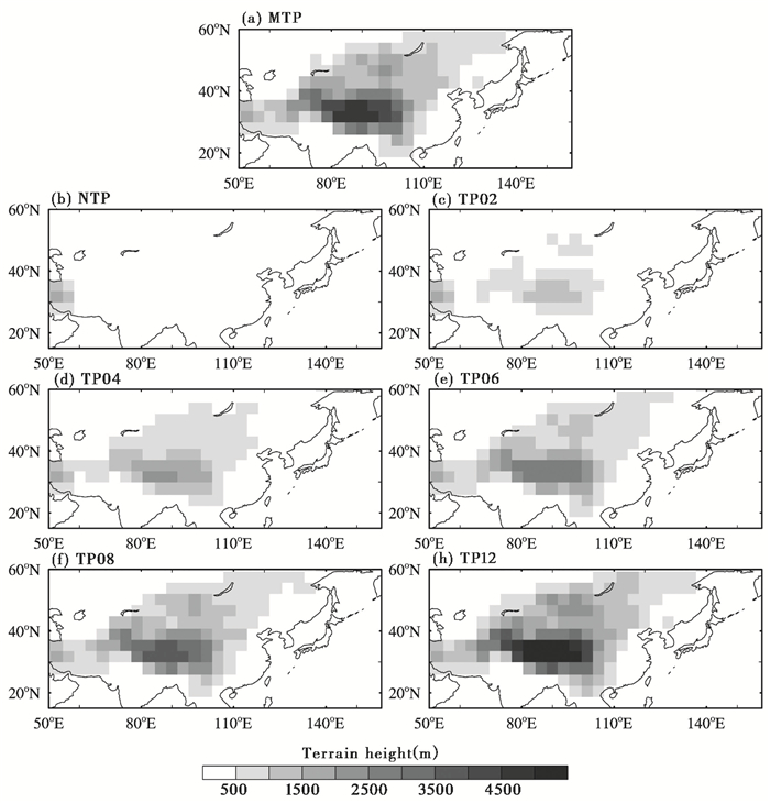
2.2 试验方案本文共设计了7个不同青藏高原地形试验情景(图 1),分别为现代高度的20%、40%、60%、80%和120%试验,以及无高原和现代地形(100%)试验。无高原试验(NTP或TP00)是将高原主体大于200m以上的高度统一降低为200m高度。为了突出高原地形变化的影响,所有试验除了地形边界条件不同之外,其他边界条件均采用工业革命前期的边界条件。这其中包括所有试验的高原下垫面的植被类型、反照率、陆地径流等均采用为模式默认的现代设置。为方便叙述,将所有试验做了简要命名,如表 1所示。所有试验积分时间均大于或者等于500个模式年,且所有试验的海洋表面温度和近地面气温均达到了准平衡态。分析结果采用模式积分达到平衡的最后100个模式年平均的气候态。
|
图 1 所有试验使用的地形边界强迫条件(单位:m) (a)现代地形;(b)无高原;(c)~(h)为20%、40%、60%、80%和120%的现代高原地形边界 Fig. 1 The topographical conditions used in the 7 experiments. (a) present-day Tibetan Plateau configuration, (b) without Tibetan Plateau, (c)~(h) correspond to experiments in which the topography configurations are 20%, 40%, 60%, 80% and 120% of the modern height(units: m) |
| 表 1 试验名称、边界条件和所对应的模拟时间长度 Table 1 Experiment name, boundary conditions, and running time |
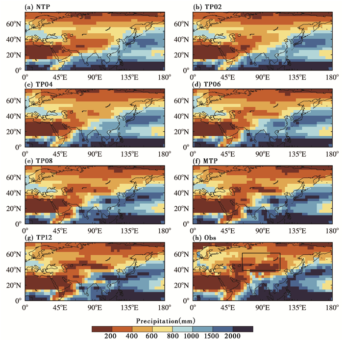
图 2描述了青藏高原隆升对欧亚大陆年总降水的影响。一般而言,年降水量可以用来划分气候带分布,小于200mm和200~400mm可分别代表干旱区和半干旱区[30]。为便于比较模式模拟的NTP~TP12所有高原试验的降水总体特征与观测的差异,图 2中将降水取为0~200mm和200~400mm两个分界,且将降水值落在这两个范围内的区域统称为干旱区。值得注意的是,模式模拟的年降水在定量上与现代观测降水会有一定差异。总体来看,所有试验模拟的降水分布格局和观测[31]一致。无高原试验的干旱区和半干旱区基本分布在20°N到40°N之间,而中纬度存在一条明显的纬向多雨带。随着高原逐渐升高,中亚副热带干旱区所在位置的北边界不断向北扩展到中纬度区域,同时其南部边界的干旱区有所收缩,这是由于高原隆升使得季风降水增多且向北扩展的缘故;因此,高原高度越接近现代高度,其模拟的降水分布越接近观测。另外,当高原高度达到现代高度约60%的时候,干旱环境的分布范围和MTP试验类似,这和以往的大气模式试验相一致[14, 32]。另一方面,有研究指出,非洲副热带干旱区几乎不依赖高原而存在[33],我们的耦合试验确实显示北非干旱区范围波动很小(图 2),这说明北非干旱区本质上应该不是青藏高原隆升的产物。
|
图 2 所有试验和观测的年总降水量(单位:mm) (a)~(g)为NTP~TP12的降水,(h)为Xie-Arkin再分析资料的年平均(1981~2010年)降水分布[31] Fig. 2 Annual total precipitation for all experiments(units: mm). (a)~(g) correspond to model experiments in which the height of the Tibetan Plateau are 0%, 20%, 40%, 60%, 80%, 100%, and 120% of modern height, respectively, and (h) annual mean precipitation(1981~2010) from Xie-Arkin[31] |

|
图 3 气候平均的500 hPa垂直速度场(单位:10-2 Pa/s;负值代表上升运动,正值代表下沉运动) (a)~(g)为NTP~TP12的垂直速度,(h)为NCEP/NCAR再分析资料1981~2010年长期平均的垂直速度分布[34] Fig. 3 Annual mean 500 hPa vertical velocity fields for all experiments(units:10-2 Pa /s). (a)~(g) correspond to model experiments in which the height of the Tibetan Plateau are 0%, 20%, 40%, 60%, 80%, 100%, and 120% of modern height, respectively, and (h) annual mean vertical velocity for 1981~2010 from NCEP /NCAR |
相应地,由年平均500hPa的大气垂直运动速度(图 3)上可以看出,中亚内陆区的垂直速度变化趋势是从无高原到有高原试验过程中下沉运动逐渐加强;而高原主体部分则随高度增加其垂直上升运动加强。高原高度越接近现代地形高度,其模拟的垂直速度分布和再分析资料的垂直速度[34]分布越接近(图 3h)。总体而言,所有试验的年平均的垂直速度变化和降水的变化是一致的。
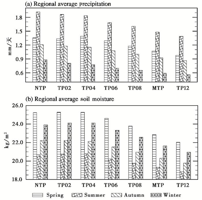
3.2 高原隆升对土壤湿度的影响土壤含水量是衡量地面干旱程度的另一指标。它是降水、蒸散发、径流等多个因子共同作用的结果。为定性研究内陆干旱环境随高原高度的演变趋势,我们计算了中亚地区(图 2h矩形区域)各季节区域平均的降水和土壤湿度。如图 4a所示,就所有试验各自降水季节循环而言,最大区域平均降水出现在夏季,最小在冬季;另外,在高原隆升过程中,中亚降水和土壤湿度在各个季节均呈现变干趋势,并且各个季节降水变化随高度上升呈现单调递减。春、夏、秋、冬降水从无高原试验(NTP)到TP12的下降幅度分别为0.38mm/天(28.0%)、0.53mm/天(27.6%)、0.35mm/天(28.7%)和0.32mm/天(36.5%),且最大下降幅度为冬季,最小为夏季,因此高原隆升导致中亚降水季节性差异增加。
|
图 4 欧亚内陆区域(40°~60°N,60°~110°E)季节平均的(a)降水(单位:mm /天)和(b)土壤含水量(单位:kg /m 2) Fig. 4 Seasonal averages of (a) precipitation(units: mm /day) and (b) soil moisture (units: kg /m 2) in the Eurasian interior (40°~60°N, 60°~110°E) for all experiments. Spring, summer, autumn, and winter are shown in different fill patterns |
与降水季节循环不一样的是,最大土壤湿度发生在春冬季节,最小在夏季(图 4b),原因在于土壤湿度还受控于蒸发和径流等因素。有意思的是,在高原较低的试验中,各个季节的土壤湿度从无高原试验(NTP)到TP04试验之间变化幅度很小,而从TP06到TP12几乎是直线下降趋势。春、夏、秋、冬4个季节土壤湿度从无高原试验(NTP)到TP12的下降幅度分别为3.19kg/m2(12.6%)、1.84kg/m2(8.9%)、2.44kg/m2(10.6%)和2.96kg/m2(12.3%)。较之于季节降水在各个试验间的变化,最大土壤湿度变化出现在春季,而最小变化仍为夏季,这进一步说明降水不是高原隆升过程中调控土壤湿度变化的唯一因子。因此,从土壤湿度角度出发,高原隆升通过降低土壤湿度而加剧干旱环境的演化,并且高度达到现代的60%及以上才开始出现显著内陆干旱。
鉴于4个季节的土壤湿度和降水都是随着地形高度增加而逐步减小,下一部分的干旱原因分析并没有逐一研究各个季节干旱环境的演化原因,而是直接研究隆升导致年平均环流的变化。
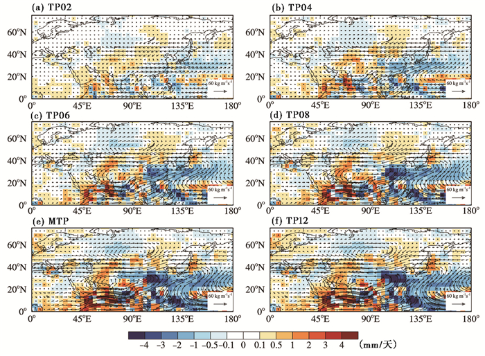
4 干旱化的原因分析 4.1 内陆干旱的环流解释地形对于中纬度干旱环境的影响可以从水汽输送的角度进行解释。相对于无高原试验的垂直积分的水汽输送,有地形试验TP02到TP12的中亚40°~60°N纬度带的西风水汽输送分量显著减少,并在TP04试验开始出现明显的闭合辐散环流中心(图 5b)。相应地,从水汽通量散度可以看出,中亚地区水汽通量为弱的辐散,且随着高原高度增加,水汽辐散加强。
一方面,在无高原条件下,由于地形静止波的阻挡和拖拽作用相对于有高原条件下显著减弱,使得中纬度盛行更强的纬向分布的西风。随着高原高度逐步增加,这个纬向西风强度开始变弱,40°~60°N纬度带的水汽输送相对于无地形试验表现为异常西向输送增加(图 5),即由大西洋和地中海的水汽源输送随地形抬升而减弱。以上结论和以往独立的大气环流模式试验是定性一致的[12];另一方面,由于水汽输送强度又受控于大气本身的含水量(大气可降水量),而可降水量和地面及低层大气温度紧密相关。由于温度垂直递减率,高原高度增加使得地面气温降低,可降水量也随之降低,有高原相比无高原背景下,欧亚内陆的大气可降水量显著减少。综上两个因素,青藏高原隆升通过减少向内陆的水汽通量,进一步减少降水和地表蒸发,从而对干旱环境形成产生影响。
|
图 5 试验TP02~TP12年平均垂直积分的水汽输送(矢量,单位:kg /m /s)及其水汽通量散度(阴影填色,mm /天;已利用假定液态水密度为103 kg /m 3将单位进行转换)相对于无高原试验NTP的变化 (a)~(f)分别为TP02、TP04、TP06、TP08、MTP和TP12试验,其中垂直积分计算从地面向上积分到300 hPa Fig. 5 The simulated changes of annually average vertically integrated moisture flux (vector, units: kg /m /s) and its convergence(contour, mm /day, the units of convergence has been converted to mm /day assuming the density of liquid water as 103 kg /m 3) relative to the NTP experiment: (a) TP02, (b) TP04, (c) TP06, (d) TP08, (e) MTP, and (f) TP12. The vertical integration is performed from the surface to 300 hPa |
此外,Kitoh[24]在早期研究中指出,海气耦合模式计算得到的夏季海洋表面温度变化会进一步反馈于大气环流,使得东亚和南亚季风降水增加,而内陆区降水减少。从我们的试验来看,高原隆升一方面导致赤道西太平洋暖池和副热带西太平洋海洋表面温度上升,另一方面导致西印度洋和副热带太平洋海洋表面变冷,这与他的海气耦合试验结果是定性一致的。考虑到Kitoh试验的海洋表面温度变化能进一步反馈于环流变化,我们试验中内陆干旱随高原隆升而加剧的原因可能有部分来自于海洋表面温度变化的反馈作用。当然,这还有待于下一步通过单独大气模式与耦合模式试验间的对比来加以检验。
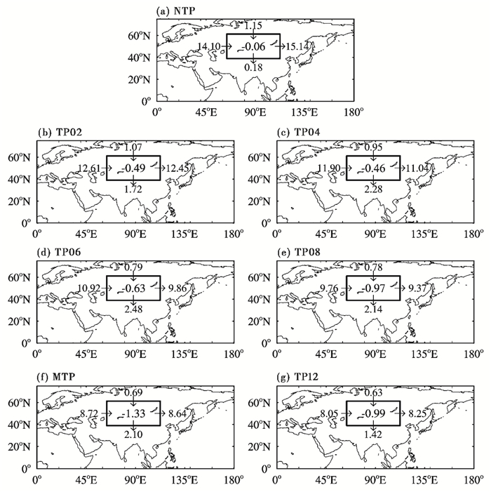
4.2 区域的水汽收支为了研究亚洲内陆区干湿变化,我们通过常用的特定区域大气水汽收支分析方法进行了定量化计算[35]。针对亚洲内陆区域(图 2h中矩形框),首先计算了单位时间内从4个边界进入框中的水汽输送质量和总水汽收支。由图 6所示,在纬向方向上,由西边界进入中亚的水汽输送在各个试验之间的变化趋势是从无高原试验的14.10×10⁷kg/s单调下降到TP12试验的8.05×107kg/s,而东边界界面则从无高原试验15.14×107kg/s单调下降到TP12的8.25×107kg/s,东-西方向减小幅度依次为6.05×107kg/s(42.2%)、2.79×107kg/s(25.3%)。由此进一步定量化了4.1一节的初步结论,即高原隆升显著减弱了西风强度及其对应的水汽输送的强度。
其次,大地形不仅可以阻挡西风纬向气流,同时也可以显著削弱经向的气流强度。一般而言,全球经向环流强度比纬向环流偏弱,由图 6可见,在经向上的水汽输送强度比纬向上小一个量级。有意思的是,中亚北部的水汽输送变化是由无高原试验的1.15×10⁷kg/s单调下降到TP12试验的0.63×107kg/s,减小幅度为0.52×107kg/s(45.2%)。而其南边界紧挨青藏高原区域的水汽输送并非简单的随高原隆升而单调变化,从无高原试验(0.18×107kg/s)到TP06(2.48×107kg/s)为向南输送增加。而从TP08(2.14×107kg/s)到TP12(1.42×107kg/s)则是向南输送减少。其可能原因是由于高原高度逐步增加,一方面可以通过热力作用加强季风环流的往北深入,另一方面则可以通过动力作用阻挡气流往南输送。因此,中亚地区南边界水汽输送随高度的复杂变化是这一对矛盾因素的共同作用结果。
|
图 6 试验NTP~TP12的年平均的垂直积分的区域水汽输送和水汽收支(单位:107 kg /s) 箭头表示进出入截面的水汽输送方向,黑色框外的数值代表其对应的水汽输送大小,黑色框内数值则代表从4个截面辐合进入该区域内的总水汽通量 Fig. 6 Annually average vertically integrated moisture transfer across four boundaries of Central Asia and total moisture budget(units:107 kg /s) for NTP~TP12. The arrows indicate the direction of moisture flux, the values outside the box stand for the moistureflux across the boundaries, and the values centered in the box is total moisture flux across the four boundaries |
最后,对所有试验总水汽输送收支的分析表明(图 6框内黑色数字),从无高原到现代地形试验过程中,水汽收支的亏损加大。但TP12(-0.99×10⁷kg/s)净的水汽输送相比MTP(-1.33×107kg/s)却略有增加(25%),这与图 4统计的该区域季节平均的降水随高原隆升而减少的结果似乎有矛盾,其原因是降水和水汽收支不是单变量的函数关系,其变化还受到蒸发的影响。随着高原隆升,内陆区域的蒸发也是逐渐减小。还需要指出的一点是,内陆干旱区对于经向环流和纬向环流的水汽输送变化非常敏感。前面提到,内陆干旱区经度方向上的水汽输送比纬度方向的水汽输送小一个量级(图 6),而经向和纬向净水汽输送对中亚区域的水汽贡献却在同一个量级上,这说明经向水汽输送尤其南边的波动变化尽管很小,但是它对于欧亚的水汽辐合贡献却不可忽略。
5 结论和展望本文设计了7组不同比例高度的青藏高原地形边界条件,利用海气耦合模式进行了长时间数值积分,模拟了亚洲内陆干旱环境对于高原隆升的敏感性。所得主要结果支持了以往单纯大气模式的试验, 即高原隆升是中亚内陆干旱加剧的重要原因。具体而言,亚洲内陆各个季节降水和土壤湿度的变化随高原的高度隆升而线性递减,并未出现显著突变;同时结合水汽通量分析表明,高原隆升显著减弱了纬向和经向的水汽输送,进而导致内陆降水减少、加剧干旱环境。
最后需要说明的是,这里采用理想化的高原隆升情景模拟了内陆干旱对高原隆升的敏感性。尽管以往采用海气耦合模式研究干旱环境演化的工作不多,但是这种简单的阶段性隆升情景相对于重建的高原生长方式的地质证据仍有较大差距。最近,已有学者利用大气环流模式和区域气候模式开展高原子区域隆升的气候效应试验[36, 37],显示不同子区域的气候作用存在差别,这对于探讨古地质记录演化和高原古高度具有借鉴意义。然而,开展高原子区域隆升的海气耦合试验意味着需要加大模式分辨率,这需要消耗更大的计算资源,因此这类试验还有待于计算条件的进一步改善。另外,高原生长经历了漫长地质时期的间歇性隆升,历经沧桑巨变,由“温室期”进入了“冰室期”,这必然产生一个科学问题,高原在不同的地质背景下的气候作用是否会有所不同,因此讨论其在不同地质时期的边界条件下的高原隆升效应也尤为重要。先前,已有大量地质记录讨论了高原隆升和亚洲季风与干旱环境演化之间在不同地质时期存在耦合关系[38~41],同时也有部分模拟研究工作讨论了始新世、中新世、上新世边界条件下的高原不同高度对欧亚和季风气候影响[32, 42, 43]。因此,未来研究中有必要考虑气候系统的多圈层耦合,采用更加真实的地质边界条件来模拟研究高原隆升的气候效应,这会有助于地质记录的解译和模式能力的验证。
致谢: 感谢审稿专家建设性的修改意见。
| 1 |
Guo Z T, Ruddiman W F, Hao Q Z, et al. Onset of Asian desertification by22 Myr ago inferred from loess deposits in China.
Nature,2002, 416 (6877) : 159~163.
( 0) 0)
|
| 2 |
安芷生, 张培震, 王二七, 等. 中新世以来我国季风-干旱环境演化与青藏高原的生长.
第四纪研究,2006, 26 (5) : 678~693.
An Zhisheng, Zhang Peizhen, Wang Erchie, et al. Changes of the monsoon-arid environment in China and growth of the Tibetan Plateau since the Miocene. Quaternary Sciences,2006, 26 (5) : 678~693. (  0) 0)
|
| 3 |
Rea D K, Snoeckx H, Joseph L H. Late Cenozoic eolian deposition in the North Pacific:Asian drying, Tibetan uplift, and cooling of the Northern Hemisphere.
Paleoceanography,1998, 13 (3) : 215~224.
( 0) 0)
|
| 4 |
方小敏, 吴福莉, 韩文霞, 等. 上新世-第四纪亚洲内陆干旱化过程-柴达木中部鸭湖剖面孢粉和盐类化学指标证据.
第四纪研究,2008, 28 (5) : 874~882.
Fang Xiaomin, Wu Fuli, Han Wenxia, et al. Plio-Pleistocene drying process of Asian inland-Sporopollen and salinity records from Yahu section in the central Qaidam Basin. Quaternary Sciences,2008, 28 (5) : 874~882. (  0) 0)
|
| 5 |
吴福莉, 赵艳, 方小敏, 等. 兰州盆地44-15Ma地层的有机碳同位素记录.
第四纪研究,2015, 35 (4) : 847~855.
Wu Fuli, Zhao Yan, Fang Xiaomin, et al. A δ 13CTOC record during44-15Ma in Lanzhou Basin. Quaternary Sciences,2015, 35 (4) : 847~855. (  0) 0)
|
| 6 |
滕晓华, 韩文霞, 叶程程, 等. 柴达木盆地SG-1孔1.0Ma以来碳酸盐同位素记录的亚洲内陆干旱化及成因.
第四纪研究,2013, 33 (5) : 866~875.
Teng Xiaohua, Han Wenxia, Ye Chengcheng, et al. Aridification of the Asian inland since1.0Ma:Evidences from carbonate isotope records of deep core from the Qaidam Basin. Quaternary Sciences,2013, 33 (5) : 866~875. (  0) 0)
|
| 7 |
Miao Y, Herrmann M, Wu F, et al. What controlled Mid-Late Miocene long-term aridification in Central Asia?-Global cooling or Tibetan Plateau uplift:A review.
Earth-Science Reviews,2012, 112 (3) : 155~172.
( 0) 0)
|
| 8 |
Lu Huayu, Guo Zhengtang. Evolution of the monsoon and dry climate in East Asia during Late Cenozoic:A review.
Science China:Earth Sciences,2014, 57 (1) : 70~79.
( 0) 0)
|
| 9 |
Tang Z H, Ding Z L, White P D, et al. Late Cenozoic Central Asian drying inferred from a palynological record from the northern Tian Shan.
Earth and Planetary Science Letters,2011, 302 (3) : 439~447.
( 0) 0)
|
| 10 |
Harrison T M, Copeland P, Kidd W, et al. Raising Tibet.
Science,1992, 255 (5052) : 1663~1670.
( 0) 0)
|
| 11 |
Molnar P, Boos W R, Battisti D S. Orographic controls on climate and paleoclimate of Asia:Thermal and mechanical roles for the Tibetan Plateau.
Annual Review of Earth and Planetary Sciences,2010, 38 (1) : 77~102.
( 0) 0)
|
| 12 |
Broccoli A, Manabe S. The effects of orography on midlatitude northern hemisphere dry climates.
Journal of Climate,1992, 5 (11) : 1181~1201.
( 0) 0)
|
| 13 |
Kutzbach J, Prell W, Ruddiman W F. Sensitivity of Eurasian climate to surface uplift of the Tibetan Plateau.
Journal of Geology,1993, 101 (2) : 177~190.
( 0) 0)
|
| 14 |
Liu X, Yin Z Y. Sensitivity of East Asian monsoon climate to the uplift of the Tibetan Plateau.
Palaeogeography, Palaeoclimatology, Palaeoecology,2002, 183 (3) : 223~245.
( 0) 0)
|
| 15 |
An Z S, Kutzbach J E, Prell W L, et al. Evolution of Asian monsoons and phased uplift of the Himalaya-Tibetan Plateau since Late Miocene times.
Nature,2001, 411 (6833) : 62~66.
( 0) 0)
|
| 16 |
Rodwell M J, Hoskins B J. Monsoons and the dynamics of deserts.
Quarterly Journal of the Royal Meteorological Society,1996, 122 (534) : 1385~1404.
( 0) 0)
|
| 17 |
Liu Y, Hoskins B, Blackburn M. Impact of Tibetan orography and heating on the summer flow over Asia.
Journal of the Meteorological Society of Japan,2007, 85B : 1~19.
( 0) 0)
|
| 18 |
Wu G X, Liu Y, Zhu X, et al. Multi-scale forcing and the formation of subtropical desert and monsoon.
Annales Geophysicae,2009, 27 (9) : 3631~3644.
( 0) 0)
|
| 19 |
Wu G, Liu Y, He B, et al. Thermal controls on the Asian summer monsoon.
Scientific Reports,2012, 2 (5) .
doi: 10.1038/srep00404 ( 0) 0)
|
| 20 |
Sato T, Kimura F. Impact of diabatic heating over the Tibetan Plateau on subsidence over Northeast Asian arid region.
Geophysical Research Letters,2005, 32 : L05809.
doi: 10.1029/2004GL022089 ( 0) 0)
|
| 21 |
张冉, 姜大膀, 刘晓东, 等. 喜马拉雅青藏高原不同子区域隆升对亚洲夏季气候演变影响的数值模拟研究.
科学通报,2012, 57 (3) : 4617~4626.
Zhang Ran, Jiang Dabang, Liu Xiaodong, et al. Modeling the climate effects of different subregional uplifts within the Himalaya-Tibetan Plateau on Asian summer monsoon evolution. Chinese Science Bulletin,2012, 57 (3) : 4617~4626. (  0) 0)
|
| 22 |
Zhang R, Jiang D B, Zhang Z S, et al. The impact of regional uplift of the Tibetan Plateau on the Asian monsoon climate.
Palaeogeography, Palaeoclimatology, Palaeoecology,2015, 417 : 137~150.
( 0) 0)
|
| 23 |
刘晓东, DongBuwen. 青藏高原隆升对亚洲季风-干旱环境演化的影响.
科学通报,2013, 58 (34) : 2906~2919.
Liu Xiaodong, Dong Buwen. Influence of the Tibetan Plateau uplift on the Asian monsoon-arid environment evolution. Chinese Science Bulletin,2013, 58 (34) : 2906~2919. (  0) 0)
|
| 24 |
Kitoh A. Effects of mountain uplift on East Asian summer climate investigated by a coupled atmosphere-ocean GCM.
Journal of Climate,2004, 17 (4) : 783~802.
( 0) 0)
|
| 25 |
Abe M, Kitoh A, Yasunari T. An evolution of the Asian summer monsoon associated with mountain uplift-Simulation with the MRI atmosphere-ocean coupled GCM.
Journal of the Meteorological Society of Japan,2003, 81 (5) : 909~933.
( 0) 0)
|
| 26 |
Okajima H, Xie S P. Orographic effects on the northwestern Pacific monsoon:Role of air-sea interaction.
Geophysical Research Letters,2007, 34 : L21708.
doi: 10.1029/2007GL032206 ( 0) 0)
|
| 27 |
Liu X, Guo Q, Guo Z, et al. Where were the monsoon regions and arid zones in Asia prior to the Tibetan Plateau uplift?.
National Science Review,2015, 2 (4) : 403~416.
( 0) 0)
|
| 28 |
Gent P R, Danabasoglu G, Donner L J, et al. The community climate system model version4.
Journal of Climate,2011, 24 (19) : 4973~4991.
( 0) 0)
|
| 29 |
田芝平, 姜大膀, 张冉, 等. CCSM4.0的长期积分试验及其对东亚和中国气候模拟的评估.
大气科学,2011, 36 (3) : 619~632.
Tian Zhiping, Jiang Dabang, Zhang Ran, et al. Long-term climate simulation of CCSM4.0 and evaluation of its performance over East Asia and China. Chinese Journal of Atmospheric Sciences,2011, 36 (3) : 619~632. (  0) 0)
|
| 30 |
伍光和, 田连恕, 胡双熙, 等.
自然地理学(第三版 ) . 北京: 高等教育出版社, 2000 : 1 ~384.
Wu Guanghe, Tian Lianshu, Hu Shuangxi, et al. Physical Geography(3rd Edition). Beijing: Higher Education, 2000 : 1 ~384. (  0) 0)
|
| 31 |
Xie P, Arkin P A. Global precipitation:A17-year monthly analysis based on gauge observations, satellite estimates, and numerical model outputs.
Bulletin of the American Meteorological Society,1997, 78 (11) : 2539~2558.
( 0) 0)
|
| 32 |
Jiang D, Ding Z, Drange H, et al. Sensitivity of East Asian climate to the progressive uplift and expansion of the Tibetan Plateau under the Mid-Pliocene boundary conditions.
Advances in Atmospheric Sciences,2008, 25 (5) : 709~722.
( 0) 0)
|
| 33 |
刘晓东, 李力, 安芷生. 青藏高原隆升与欧亚内陆及北非的干旱化.
第四纪研究,2001, 21 (2) : 114~122.
Liu Xiaodong, Li Li, An Zhisheng. Tibetan Plateau uplift and drying in Eurasian interior and Northern Africa. Quaternary Sciences,2001, 21 (2) : 114~122. (  0) 0)
|
| 34 |
Kalnay E, Kanamitsu M, Kistler R, et al. The NCEP/NCAR40-year reanalysis project.
Bulletin of the American Meteorological Society,1996, 77 (3) : 437~471.
( 0) 0)
|
| 35 |
Fasullo J, Webster P. Hydrological signatures relating the Asian summer monsoon and ENSO.
Journal of Climate,2002, 15 (21) : 3082~3095.
( 0) 0)
|
| 36 |
Tang H, Micheels A, Eronen J T, et al. Asynchronous responses of East Asian and Indian summer monsoons to mountain uplift shown by regional climate modelling experiments.
Climate Dynamics,2013, 40 (5-6) : 1531~1549.
( 0) 0)
|
| 37 |
张冉, 刘晓东. 上新世以来构造隆升对亚洲夏季风气候变化的影响.
地球物理学报,2010, 53 (6) : 948~960.
Zhang Ran, Liu Xiaodong. The effects of tectonic uplift on the evolution of Asian summer monsoon climate since Pliocene. Chinese Journal Geophysics,2010, 53 (6) : 948~960. (  0) 0)
|
| 38 |
郭正堂, 彭淑贞, 郝青振, 等. 晚第三纪中国西北干旱化的发展及其与北极冰盖形成演化和青藏高原隆升的关系.
第四纪研究,1999 (6) : 556~567.
Guo Zhengtang, Peng Shuzhen, Hao Qinzhen, et al. Late Tertiary development of aridification in Northwestern China:Link with the arctic ice-sheet formation and Tibetan uplifts. Quaternary Sciences,1999 (6) : 556~567. (  0) 0)
|
| 39 |
刘东生, 郑绵平, 郭正堂. 亚洲季风系统的起源和发展及其与两极冰盖和区域构造运动的时代耦合性.
第四纪研究,1998 (3) : 194~204.
Liu Tungsheng, Zheng Mianping, Guo Zhengtang. Initiation and evolution of the Asian monsoon system timely coupled with the ice-sheet growth and the tectonic movements in Asia. Quaternary Sciences,1998 (3) : 194~204. (  0) 0)
|
| 40 |
马小林, 田军. 15Ma以来海陆记录的轨道-构造尺度东亚季风的演化以及西北内陆的干旱化.
第四纪研究,2015, 35 (6) : 1320~1330.
Ma Xiaolin, Tian Jun. East Asian monsoon evolution and aridification of Northwest China viewed from land and sea on the tectonic-orbital time scale since15Ma. Quaternary Sciences,2015, 35 (6) : 1320~1330. (  0) 0)
|
| 41 |
脱世博, 方小敏, 宋春晖, 等. 青藏高原东北部西宁盆地晚渐新世-早中新世沉积物岩石磁学特征及其古环境意义.
第四纪研究,2013, 33 (5) : 829~838.
Tuo Shibo, Fang Xiaomin, Song Chunhui, et al. Rock magnetic characteristics of the Late Oligocene to Early Miocene sediments in the Xining Basin, northeastern Tibetan Plateau. Quaternary Sciences,2013, 33 (5) : 829~838. (  0) 0)
|
| 42 |
Fluteau F, Ramstein G, Besse J. Simulating the evolution of the Asian and African monsoons during the past30 Myr using an atmospheric general circulation model.
Journal of Geophysical Research:Atmospheres,1999, 104 (D10) : 11995~12018.
( 0) 0)
|
| 43 |
Zhang Z, Wang H, Guo Z, et al. What triggers the transition of palaeoenvironmental patterns in China, the Tibetan Plateau uplift or the Paratethys Sea retreat?.
Palaeogeography, Palaeoclimatology, Palaeoecology,2007, 245 (3) : 317~331.
( 0) 0)
|
②. University of Chinese Academy of Sciences, Beijing 100049;
③. CAS Center for Excellence in Tibetan Plateau Earth Sciences, Beijing 100101;
④. Climate Change Research Center, Chinese Academy of Sciences, Beijing 100029)
Abstract
As one of the most important geological events in the Cenozoic Era, the Tibetan Plateau (TP) uplift not only exerts profound influences on its own environment evolution, but also plays a key role in driving the global weather and climate evolution. The effect of the TP uplift in forming the mid-latitude dry climates has been demonstrated by a growing number of geologic evidences and numerical experiments. However, most of experiments are based on atmospheric general circulation model (AGCM), and the coupled atmosphere-ocean model(CGCM)experiments have not been widely undertaken. In order to address this issue, the Community Earth System Model (CESM) of National Center for Atmospheric Research(NCAR)is used to design seven simulations in total. The CESM consists of atmosphere, land, ocean, and sea ice components that exchanges state information and fluxes through a coupler. The low-resolution (about 3.75°×3.75°) version of CESM is less computationally expense and widely used for a variety of applications. In seven experiments, various TP heights are used: 0 % (no TP), 20 %, 40 %, 60 %, 80 %, 100 % (modern TP), and 120 % of the modern TP heights. The other boundary conditions are the same for all experiments. All the experiments are integrated for more than 500 model years and have reached an equilibrium state. The analysis of regional average of precipitation and soil moisture changes over the Asian inland is performed in this study. In addition, the method of vertically integrated moisture transport across the four boundaries of the Asian inland is used to quantitatively measure the total moisture budget in this area. Systematic changes in precipitation pattern and circulation fields as well as total moisture fluxes occurred along with progressive mountain uplift. In the experiment without TP, the subtropical belts of aridity in Asia are nearly zonal distribution. With the uplifting of mountain, the East Asian monsoon intensifies and extends northward, while the westerlies into the Eurasia become weaker. As a result of that, the east-west variation of subtropical dryness becomes more evident, and the area of mid-latitude dryness substantially increases. On one hand, the low layer atmosphere temperature decreases with the uplifting of TP, leading to the reduction of atmospheric water vapor content. On the other hand, the circulation in both meridional and zonal directions is greatly reduced because of blocking effect of large mountains. These two factors that combine to induce the total moisture convergence in Central Asia dramatically to decrease are the main dynamic mechanism behind Asian inland dryness. In agreement with previous works, the coupled atmosphere-ocean model simulations reinforce the existing scientific understanding that the TP uplift plays key roles in significantly enhancing the arid environments located in the Eurasia on the tectonic scale. 2016, Vol.36

