②. 中国地震局兰州地震研究所, 兰州 730000;
③. 中山大学地球科学与地质工程学院, 广州 510275;
④. 宁夏回族自治区地震局, 银川 750001)
青藏高原东北缘构造位置上处于青藏高原与华北克拉通的交汇部位,西南一侧是以地壳缩短增厚为主要变形特征的正在发育和扩展的青藏高原,以东则是自中生代以来不断遭受破坏的以构造拉伸减薄为特征的华北克拉通。该地区晚第四纪构造变形强烈、活动构造发育、地震活动频繁,其中祁连山和河西走廊地区不仅是高原扩展的最前缘,也是高原最新的、正在形成的组成部分[1~9]。漫长而复杂的地质演化过程同时造就了青藏高原东北缘现今复杂的地貌特征,从祁连山地区的平均海拔3000m以上,向北东到了河西走廊及阿拉善地区,平均海拔则突然降到了只有1000余米[10~17]。由于该地区特殊的构造位置和强烈的地震活动,其新构造与活动构造一直为人们所关注[4~6, 18~24];另外,由于印度板块和欧亚板块的碰撞形成世界上最大最高的高原——青藏高原,同时也改变了高原周边的构造格局和气候环境[8, 25~34]。受印度板块不断向北推挤的影响,青藏高原东北缘的祁连山地区与华北克拉通西南部的阿拉善地块之间形成了一系列平行于块体边缘的构造带,发育了不同规模、不同性质的断裂、褶皱和新生代沉积盆地等[4~6, 8, 22, 23, 34],而广泛分布的活动构造不仅控制着区域构造格局和形态,同时也控制着该地区强震的发生[9, 16, 35, 36]。
活动构造的研究和发展从20世纪70年代末开始,已经从描述性和定性研究阶段发展到定量研究阶段[37~41]。近年来,随着新的测年技术发展和高精度测量方法的逐步引入,活动构造的定量研究也逐步开始关注提高测年精度、减少研究过程各个环节的误差和不确定性[6, 9, 37, 42~45];另外,随着构造地质学新理论的发展,提出了构造转换、应力分配等概念,并不断利用活动构造的定量结果的分布和变化来解释构造之间的转换关系和区域构造变形模式[2, 3, 5, 7, 42, 46, 47]。青藏高原东北缘地区目前开展了大量的活动构造研究,积累了大量的定量数据,非常有必要加以总结和归纳。本文从青藏高原东北缘的活动构造几何图像和运动图像入手,重点总结和讨论青藏高原东北缘不同构造部位的断裂运动特征和构造转换模式,结合新生代构造变形的年代框架、变形模式和演化过程,进而探讨青藏高原东北缘活动构造的形成、演化与高原扩展之间的关系。
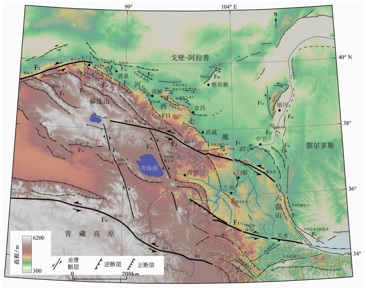
2 青藏高原东北缘活动构造的几何图像和运动图像的基本格架青藏高原东北缘是高原的重要组成部分,也是高原生长和扩展的最前缘。印度板块与欧亚板块碰撞后,高原逐渐形成并向周边发生有序的扩展[6, 8, 43, 48~52],在青藏高原东北缘逐步形成了现今的地貌和构造格局[13, 20, 21]。近十几年来,国内外学者通过该地区活动断裂的大比例尺填图、局部高精度定量研究,积累了大量的基础资料和数据[5, 8, 9, 52]。在邓起东等[18]编制的活动构造图的基础上,结合袁道阳等[52]的青藏高原东北缘新构造与活动构造研究结果,我们逐步完善了青藏高原东北缘地区活动构造几何图像和运动学图像。综合分析结果表明,青藏高原东北缘的祁连山地区构造变形样式并非简单的“薄皮”构造样式,在平面上,该地区及周边区发育有3组不同走向、不同性质的活动断裂或断裂带(〖XC0;Y-1〗图 1),各组活动断裂的特征简述如下。
|
图 1
青藏高原东北缘活动构造展布图
资料来源于文献[5, 6, 8, 9, 18, 24, 43, 45, 52, 55] 图中断层名称:F1——祁连-海原断裂带,F2——阿尔金断裂带,F3——西秦岭断裂带,F4——东昆仑断裂带,F5——香山-天景山断裂带,F6——陇县-岐山-马召断裂,F7——六盘山断裂带,F8——党河南山断裂,F9——野马河-大雪山断裂,F10——昌马-俄博断裂带,F11——祁连山北缘断裂带,F12——玉门断裂,F13——嘉峪关断裂,F14——金塔南山断裂,F15——合黎山南缘断裂,F16——龙首山断裂带,F17——鄂拉山断裂,F18——拉脊山断裂,F19——柴达木盆地北缘断裂带,F20——雅布赖山断裂,F21——三关口-牛首山断裂,F22——贺兰山西麓断裂,F23——罗山东麓断裂,F24——黄河断裂 图中断层上字母及数字:H:0.5表示断层水平走滑速率为0.5mm/a,V:0.5表示断层垂直滑动速率为0.5mm/a Fig. 1 Distribution of active faults in the northeastern Tibetan Plateau. Data from references[5, 6, 8, 9, 18, 24, 43, 45, 52, 55]. In Fig. 1, “H:0.5”on the fault indicates the horizontal slip rate of 0.5mm/a and“V:0.5”is vertical slip rate of 0.5mm/a |
(1)近东西-北东东向的断裂或断裂带:这组断裂主要是青藏高原东北缘地区的两条主要边界控制断裂带—祁连-海原断裂带(F1)、阿尔金断裂带(F2)及与之相关的次级断裂。这组断裂以左旋走滑运动为主要特征,滑动速率在空间上分布表现为中段速率高而稳定,到了端部逐渐降低的弧形分布特征,端部的走滑速率约为1~2mm/a并发育有调节性的逆冲断裂和褶皱等,如祁连-海原断裂带(F1)的中段左旋走滑速率约为5mm/a,到了西段的哈拉湖一带降低到1~2mm/a,东端的六盘山一带为1~3mm/a,并逐渐转换到逆冲为主的断裂带上,特别是东端部发育有大量的新生代褶皱和逆冲断裂[5, 8, 42~44, 52~54];阿尔金断裂带中段左旋走滑速率为8~12mm/a,向东到肃北县城以西开始降低,从4~5mm/a逐渐降到东端部的1~2mm/a[5, 24, 47],并且在东端主要发育北西向展布的逆冲断裂和狭长的新生代盆地(褶皱)等[5, 13, 43]。
(2)北西西向断裂:主要分为两组,一组为两条近东西-北东东向边界走滑断裂之间和端部的逆冲断裂,如阿尔金断裂(F2)和祁连-海原断裂(F1)之间发育的党河南山断裂(F8)、野马河-大雪山断裂(F9)、昌马-俄博断裂带(F10)、祁连山北缘断裂带(F11)、祁连-海原断裂东端部的六盘山断裂带(F7);另一组主要包括河西走廊内部和北侧的玉门断裂(F12)、嘉峪关断裂(F13)、金塔南山断裂(F14)、合黎山南缘断裂(F15)和龙首山断裂带(F16)等,这组断裂多以逆冲为主,单条逆冲断裂的逆冲或缩短速率一般为0.5~1.0mm/a,有些甚至更低,仅为0.1~0.3mm/a[5]。
(3)北北西向断裂:主要位于祁连山南部,包括鄂拉山断裂(F17)和拉脊山断裂(F18)等,这组断裂以右旋走滑为主,右旋滑动速率一般为1~3mm/a[53],这组断裂分隔了祁连山南部的柴达木盆地、茶卡-共和盆地和西宁盆地,起到了调节块体之间运动平衡的作用。
青藏高原东北缘的祁连山及邻近地区在上述3组断裂带的共同控制下,呈现出山体两侧向山前盆地双向逆冲、山体内部发育走滑断裂、走滑断裂在端部转换为地壳缩短的特征(图 1)。而这些断裂和褶皱的相互作用和转换构成了青藏高原东北缘的构造变形图像,同时也表明青藏高原东北缘的向外扩展是通过一系列北西西向逆冲断裂和褶皱实现的。不同时段构造发育、生长和性质变换等的共同作用形成了现今祁连山乃至青藏高原东北缘地区构造变形的总体格架[5, 6, 8, 9, 18, 24, 43, 45, 52, 55]。
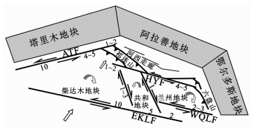
3 青藏高原东北缘活动构造控制的变形模式与运动转换 3.1 阿尔金与祁连-海原两大边界走滑断裂控制下的区域构造变形模式断层滑动速率,特别是晚第四纪以来的滑动速率是断层最新运动特征的表现,同时也反映了区域动力学的主要特征。近年来,在青藏高原东北缘祁连山及周边地区的断裂滑动速率定量研究方面取得了很大的突破和进展,现今GPS观测网络也获取大量跨断层速率,积累了丰富的研究成果[5, 56~58]。基于断裂晚第四纪滑动速率及现今GPS观测结果,Zheng等[5]建立了青藏高原东北缘主边界走滑断裂上运动转换模式,揭示了青藏高原向北扩展与高原边缘隆升的运动学特征。研究结果显示,青藏高原东北缘的断裂以低滑动速率(<10mm/a)为主要特征,特别是两条边界断裂:阿尔金断裂(F2)和祁连-海原断裂(F1)。两条主边界断裂上的滑动速率显示了滑动速率沿断裂的分布变化特征及断裂间的滑动速率转换及调整,同时也揭示了青藏高原东北缘是在两条主边界走滑断裂控制下发生构造变形的。其中,阿尔金断裂自95°E以西的8~12mm/a稳定滑动速率,向东逐渐降低到最东端约为1~2mm/a,而海原断裂自哈拉湖一带开始发育后滑动速率为1~2mm/a,到祁连一带(101°E以东)增大到相对稳定的4~5mm/a,直到过海原后转向六盘山一带,滑动速率降低到1~3mm/a,甚至更低[5]。这些滑动速率的变化及空间分布特征显示[5, 8, 24, 45, 55],阿尔金断裂的滑动主要是通过祁连山内部隆起及两侧新生代盆地变形引起的地壳缩短来吸收的,祁连-海原断裂的低滑动速率及沿断裂运动学特征表明断裂尾端的陇西盆地变形及六盘山的隆起是断裂左旋走滑速率的主要吸收方式( 图 2)。阿尔金断裂东端与祁连-海原断裂西端构成了一个巨大的挤压阶区,控制了祁连山西段的地壳挤压缩短[5, 23, 56],同时也调节了二者之间的运动平衡与转换。这一变形特征表明,青藏高原东北缘的变形模式是一种分布式的连续变形,变形发生自高原内部,边界断裂的走滑被高原内部变形所吸收。
|
图 2
青藏高原东北缘主要断裂构造运动转换简化模式
图中数字表示主要断裂的走滑速率(mm/a), 数据来源于文献[5, 8, 24, 45, 55] AFT——阿尔金断裂带(F2);HYF——祁连-海原断裂带(F1);WQLF——西秦岭断裂带(F3);EKLF——东昆仑断裂带(F4) Fig. 2 Kinematic transformation pattern along main active tectonics in the NE Tibetan Plateau. Data from references[5, 8, 24, 45, 55] and the numbers along different fault indicate the strike slip rate(mm/a) |
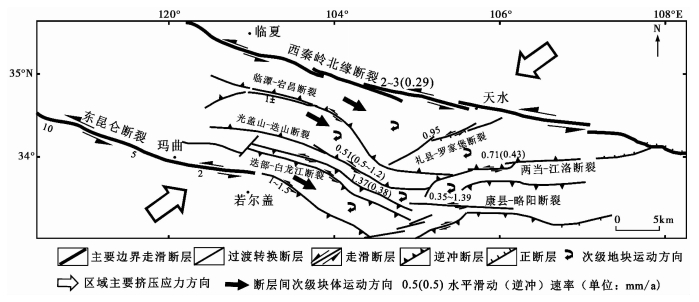
位于南北地震带中北段的甘东南地区,其构造变形和构造活动特征与青藏高原向北东方向的扩展密切相关,该地区复杂的构造几何形态主要受控于西秦岭北缘断裂(F3)和东昆仑断裂(F4),区域新构造运动的主要动力来源于青藏高原向北东方向的扩展[45, 46, 59~61]。甘东南地区复杂的构造体系是由多条活动断裂所组成( 图 1和图 3),对于区域控制性断裂之一的东昆仑断裂(F4),Kirby等[45]通过河流阶地断错及其年代学的研究,认为其左旋走滑速率从中段的约10mm/a向东逐渐减弱,至玛曲以东一带仅为约2mm/a,向东延伸到了塔藏断裂的左旋走滑速率为1.0~1.5mm/a,同时具有少量的逆冲分量[62];而另一条主要控制性断裂西秦岭北缘断裂(F3)的左旋走滑速率只有2~3mm/a[55]。位于两条控制性断裂之间的起构造转换作用的断裂,左旋走滑速率多为1~2mm/a,同时大部分断裂具有逆冲性质,逆冲速率一般小于1mm/a[63~65]。
|
图 3 甘东南地区活动构造运动转换 修改于文献[52, 61, 66] Fig. 3 Tectonic transition of active fault in southeastern Gansu Province, modified from references[52, 61, 66] |
从区域构造图像上看( 图 3),在东昆仑断裂(F4)和西秦岭北缘断裂(F3)之间构成一个巨大的左阶岩桥区[52, 61, 66],张国伟等[67, 68]从深部构造上提出了“立交桥”模式,位于二者之间的甘东南地区发育的一系列近于平行的断裂及与这些断裂组成“V”字型的断裂系统的其他断裂,通过各条断裂相对较低的滑动速率(包括了走滑和逆冲),以及断裂之间山脉隆起和不同时代盆地的变形,共同承担了自东昆仑断裂向西秦岭北缘断裂过渡过程中运动分量吸收和转换[61, 65]。也就是说东昆仑断裂与西秦岭北缘断裂走滑速率的不一致,主要是被包括临潭-宕昌断裂、光盖山-迭山断裂带、迭部-白龙江断裂带等一系列断裂的走滑和逆冲变形及断裂之间地壳的缩短共同吸收和调节[52, 66]。GPS观测结果及第四纪滑动速率的综合分析结果也表明,东昆仑断裂的变形并非往东传递,而是向北传递,西秦岭北缘断裂及甘东南地区复杂的断裂体系在高原整体变形过程中起到重要作用,吸收和转换了东昆仑断裂往北传递过程中的部分运动分量[46]。
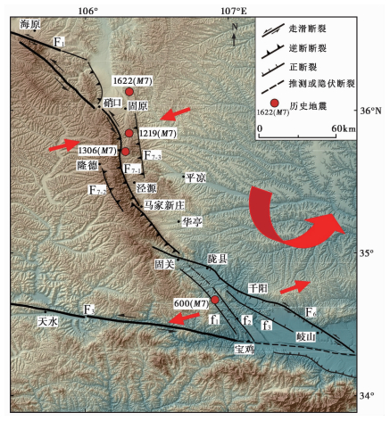
3.3 六盘山地区的活动断裂运动特征与构造转换六盘山不仅是青藏高原与鄂尔多斯块体之间的边界带,同时也是祁连-海原断裂东端部逆冲的重要组成部分[5, 42, 69~71]。六盘山断裂带主体上可分为北段、中段和南段,其中北段和中段由3条主要断裂带组合而成,包括六盘山东麓断裂(F7-1)、六盘山西麓断裂(F7-2)、小关山断裂(F7-3)3条主干活动断裂带[72, 73](图 4)。六盘山断裂北段与祁连-海原断裂斜接,其性质表现为左旋走滑兼逆冲,向宏发等[54]获得了六盘山东麓断裂带北段晚第四纪以来的左旋水平滑动速率为1~3mm/a,垂直滑动速率为0.9mm/a;而史志刚[74]通过对断裂最新断错位移的测量和断错地貌年代确定,给出了该段在约4ka B.P.以来的左旋滑动速率约为3.2±0.5mm/a,为一条逆冲兼左旋走滑断裂——这个结果可能是该断裂上滑动速率的最大值。断裂的中段为六盘山断裂的主体部分,包括东、西两条断裂,均具有明显的逆冲性质。其中六盘山东麓断裂全新世以来逆冲滑动速率为约0.8mm/a,六盘山西麓断裂晚更新世晚期以来没有明显的活动[74]。虽然也有人提出六盘山东麓断裂具有左旋走滑性质[72, 74],但其地貌特征的表现已不明显,而且从六盘山两侧现代水系发育分析,构造作用对地貌形成有明显的控制作用[75]。到了南段,断裂性质发生明显的变化,由多条断裂组成,其中包括:桃园-龟川寺断裂(f1)、固关-虢镇断裂(f2)、千阳-彪角断裂(f3)和陇县-岐山-马召断裂(F6),这4条断裂呈帚状自西北向东南撒开,构成了六盘山断裂带的南端。近年来的野外调查和综合研究结果表明,这4条断裂的主支断裂是陇县-岐山-马召断裂(F6),表现为明显的左旋走滑兼具正断特征,根据我们近两年调查的结果(暂时没有公开发表),其最新一次地震的同震水平位移量为约3.5m,垂直位移量为约1.7m,根据冲沟断错和地貌陡坎估算的左旋滑动速率为2~3mm/a,垂直滑动速率小于约1mm/a,而其他几条断裂第四纪活动性较弱,均表现为正断为主。
|
图 4
六盘山断裂构造几何图像和运动特征
断裂资料来源于文献[72~74] 图中红色箭头指示区域应力方向和块体运动方向;图中断层名称:F1——祁连-海原断裂带,F3——西秦岭断裂带,F6——陇县-岐山-马召断裂,F7——六盘山断裂带(包括:F7-1六盘山东麓断裂,F7-2六盘山西麓断裂,F7-3小关山断裂);f1——桃园-龟川寺断裂,f2——固关-虢镇断裂,f3——千阳-彪角断裂 Fig. 4 Geometry and kinematics of Liupanshan active tectonic zone. Faults data from references[72~74]. The red arrows indicate the direction of the regional stress and the block movement in figure |
在区域构造转换方面,海原断裂向东的延伸到达六盘山后,其尾端的左旋走滑速率逐渐转换成了端部新生代盆地变形、断裂的逆冲和山脉的隆升[5, 42, 70],六盘山的快速隆升和两侧盆地的缩短变形就是海原断裂与六盘山之间构造转换的结果[5, 42, 69, 70],而六盘山中段在一个相对较窄范围内的高差变化更是表明了六盘山断裂带在构造转换中所起的关键作用。另外,在总体构造框架上,祁连-海原断裂与陇县-岐山-马召断裂之间形成了一个左旋右阶的挤压阶区,祁连-海原断裂的4~5mm/a左旋走滑速率[5, 44],经过六盘山隆起、断裂的逆冲和两侧的新生代盆地变形的吸收和转换,到了陇县-岐山-马召断裂上左旋走滑速率为2~3mm/a(笔者未公开发表数据),这一特征与规模相对较大的阿尔金断裂与祁连-海原断裂之间的构造转换[5]有一定的相似性;另外,由于陇县-岐山-马召断裂向南延伸与以正断为主的渭河断裂系相联接,其运动性质也表现为正断特征。
3.4 三关口-牛首山断裂的右旋走滑三关口-牛首山断裂带(F21)位于青藏高原、阿拉善、鄂尔多斯3个地块的复合交接之处( 图 1),构造位置非常重要[9, 18, 20]。前人的研究对三关口-牛首山断裂存在明显的认识分歧:一部分认为该断裂向南与罗山东麓断裂相连,向北与贺兰山西麓断裂右阶斜接,为一条晚更新世活动的左旋走滑断裂[76~79];也有部分学者认为,该断裂向北在元山子或吉井子转为东西向,向西和查汗布拉格断裂相连,最终与龙首山南缘断裂相接[80~84]。但是,最新的研究认为河西走廊北侧的合黎山南缘-龙首山断裂以逆冲为主要特征,是高原向北挤压扩展的前缘[6, 36],与三关口-牛首山断裂带的运动学性质存在明显的差异。近年来,随着罗山东麓断裂晚第四纪右旋走滑性质的发现,又提出三关口-牛首山断裂向南不应与罗山东麓断裂相连的观点[85]。
雷启云等[86]在野外调查的基础上,通过大比例尺地质填图、典型地貌测量和地貌面年代测定等,确定该断裂带是一条具有明显右旋走滑特征的断裂。断裂沿线发现了形成于古生代、中生代、新生代的地层界线均被断层右旋错动,且断错位移相近,大约为960m左右;另外,断裂三关口段一系列小冲沟的同步右旋扭动,由此获得的断裂晚第四纪以来平均水平滑动速率约为0.35mm/a[86]。根据褶皱变形和断裂活动的先后关系分析,在上新世末(约2.7Ma)青藏高原向北东扩展到达三关口-牛首山一带,导致该区域地层发生广泛的褶曲变形和区域性抬升。到第四纪初,受青藏高原东北向推挤和鄂尔多斯地块逆时针旋转的联合作用,三关口-牛首山断裂开始右旋走滑活动,形成了青藏高原东北缘弧形构造带扩展的最前缘边界[86]。
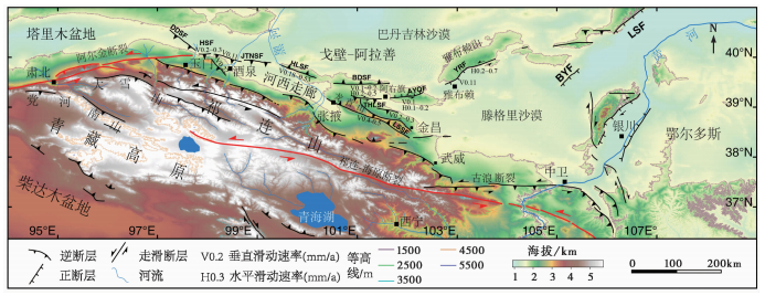
3.5 阿拉善地块南缘活动构造的运动图像特征最新的研究发现,在阿拉善地块南缘存在大量规模较大的活动断裂[6, 43, 87~90],这些断裂的运动性质与青藏高原东北缘边缘和内部的断裂存在明显的不同( 图 1和图 5)。河西走廊西端的嘉峪关断裂和河西走廊北部的金塔南山断裂断错的北大河高阶地,Zheng等[43]基于宇宙成因核素定年得到了阶地暴露年代为10~11万年,并利用高精度差分GPS对其断错洪积扇上位移进行了测量,得到了嘉峪关断裂晚更新世以来的逆冲滑动速率为0.22±0.03mm/a,金塔南山断裂为0.11±0.02mm/a;特别是通过大量的洪积扇面年代样品的测试和陡坎测量,获得了河西走廊北部合黎山南缘断裂不同段落的逆冲滑动速率分别为西段0.18~0.20mm/a,中段0.30~0.43mm/a,东段0.36~0.53mm/a[6]。而向东延伸,阿拉善地块南缘过渡地区的龙首山北缘断裂是一条北西走向以逆冲性质为主的断裂,逆冲速率小于0.5mm/a[91],龙首山北缘断裂以北的桃花拉山-阿右旗断裂带走向近东西,该断裂带包括桃花拉山断裂和阿右旗断裂,其中桃花拉山断裂为走滑兼逆冲性质,走滑速率约为0.1~0.2mm/a,逆冲速率小于0.1mm/a,而阿右旗断裂则具有走滑兼正断性质,走滑速率约为0.1mm/a左右,垂直滑动速率小于0.1mm/a(暂未公开发表)。到了阿拉善块体内部雅布赖山前断裂,其各段性质存在明显的差异:西南段表现为以正断性质为主,局部发现有左旋运动,中段为正断活动,北东段以左旋走滑为主,并伴有逆冲分量。Yu等[87]根据对山前断错洪积扇面的宇宙成因核素(10 Be)测年以及差分GPS测量结果,获得雅布赖山前断裂南西段晚更新世以来的垂直滑动速率约为0.1mm/a,北东段的左旋走滑速率约为0.23±0.02~0.78±0.12mm/a。
|
图 5
祁连山—河西走廊—阿拉善地块南部活动断裂分布及阿拉善地块南部断裂滑动速率
图修改于文献[87],图中滑动速率资料来源于文献[6, 36, 43, 87, 88] 阿拉善块体南部主要断裂名称自西向东为:DDSF——磴磴山断裂,HSF——黑山断裂,JTNSF——金塔南山断裂(F14),HLSF——合黎山断裂(F15),BDSF——北大山断裂,THLSF——桃花拉山断裂,AYQF——阿右旗断裂,YRF——雅布赖山断裂(F20),LSSF——龙首山断裂带(F16),BYF——巴彦乌拉山断裂,LSF——狼山山前断裂 Fig. 5 Active faults in Qilian Mountains, Hexi Corridor and the southern Alashan block, and Late Quaternary slip rates(mm/a) of active faults in the southern Alashan block. Modified from reference[87] and data of slip rates from references[6, 36, 43, 87, 88] |
以上这些研究突破了以往认为的阿拉善块体不存在规模较大的活动构造的认识,表明在新生代晚期已开始逐渐发育有新的活动断裂,而这些不同规模的活动断裂,不仅控制着其边缘的形态,同时也对完整的阿拉善块体产生了进一步的破坏。块体边缘不同位置断裂性质的差异说明了青藏高原向北东方向发生扩展的过程中对阿拉善块体不同部位产生了不同的影响,在西段和中段由于位于高原向北东推挤和扩展的最前缘,阿拉善块体边缘新生的断裂均表现出不同方向的逆冲性质,说明该部位是以挤压为主。在东段由于受到青藏高原的向北东扩展影响,以及鄂尔多斯地块逆时针旋转的共同作用,自阿右旗一带向东的断裂,表现出左旋走滑的特征,可能主要为调节和适应不同块体之间运动性质的差异。
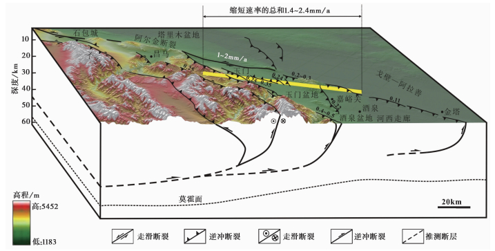
4 青藏高原东北缘活动构造的发育与高原扩展 4.1 阿尔金走滑断裂尾端定量运动转换与断裂延伸青藏高原东北缘构造动力学演化过程的两个主导模型(即大陆逃逸和连续变形)中,走滑断裂的作用是争论的焦点,特别是高原东北缘的阿尔金断裂[2, 5, 7, 8, 24, 26, 92~97]。前已述及,地质速率和GPS观测结果显示,阿尔金断裂中段稳定的8~12mm/a的滑动速率到了祁连山南部开始降低,到达祁连山北部后降低到了1~2mm/a,滑动速率的降低逐步转换为祁连山内部隆起、断裂逆冲、山间及两侧新生代盆地变形[5],那么在量上是否达到平衡?垂直于祁连山西段的GPS速率剖面显示了横穿整个祁连山的GPS地壳缩短率为7.5±2.0mm/a[5, 58],同时也显示缩短发生在整个祁连内部南北方向约200~250km范围内[5],这一结果与祁连山西段平行于阿尔金断裂方向上逆冲断裂的缩短和新生代盆地变形的缩短总和相当[5, 13, 52]。对河西走廊西端酒西盆地内逆冲断裂的研究表明,盆地边缘和内部的逆冲断裂在平行阿尔金断裂方向上的缩短速率为0.90~1.43mm/a[43],而盆地内新生代褶皱在平行于阿尔金断裂方向上的缩短速率总和是0.5~1.0mm/a,二者之和为1.4~2.4mm/a[98],与阿尔金断裂尾端1~2mm/a[5, 24, 99]走滑速率相当( 图 6)。这进一步定量说明了阿尔金断裂的走滑已经完全被其端部山脉隆起、盆地变形和逆冲断裂所吸收和转换[5, 43, 100, 101],阿尔金断裂尾端终止于河西走廊西端的酒西盆地西北宽滩山一带,并没有向阿拉善块体内部延伸,阿拉善地块内部和边缘新生的活动断裂应该是高原整体向东北方向扩展和隆升的结果。
|
图 6 阿尔金断裂东端部断裂图像与运动转换模式 资料来源于文献[5, 43, 100, 101],图中沿断裂表示的数字为断裂上的滑动速率,黑色字体为逆冲速率,白色为走滑速率 Fig. 6 Kinematic deformation pattern near the east end of the Altyn-Tagh Fault and data from references[5, 43, 100, 101]. The black number along different fault indicates the thrust slip rates and the white is strike slip rate(mm/a) |
青藏高原东北缘存在两个较为重要的构造变形位置,一个是阿尔金断裂东端的河西走廊盆地西段,另一个是海原断裂东端的东北缘弧形构造带位置( 图 1)。这两个关键位置构造变形时空演化序列是最能反映和代表高原东北缘向外扩展与演化过程。最新的研究结果展示了高原在这两个位置的有序向外扩展的过程和模式[4, 6, 102, 103]。
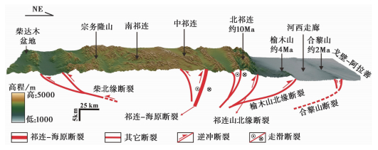
在阿尔金断裂东端部的河西走廊西段,前已述及,阿尔金断裂尾端终止于河西走廊西段的酒泉盆地西北的宽滩山一带,那么高原向北东方向推挤过程中是如何扩展的?低温热年代学获得的祁连山北缘的快速隆升时间约为距今10Ma左右,由此估算的其隆升速率约为0.5mm/a,与断裂的逆冲速率相当[102];沉积地层的年代结果与构造变形分析认为位于酒西盆地白杨河背斜的构造隆升时间是3~4Ma[103],
而Palumbo等[4]根据活动断裂与地貌面测年结果,估算了位于河西走廊内部的隆起,即榆木山的隆升时间约为3.7Ma,与通过河西走廊西段新生代地层研究所获得的结果[103]一致,均晚于祁连山北缘约10Ma的快速隆升时间[102];在河西走廊中段北侧缺乏完整的新生代地层,无法直接确定准确的构造隆升时间,然而根据河西走廊中段合黎山南缘断裂运动学特征的研究结果[6],结合其现今地形地貌特征,我们估算合黎山在距今约2Ma左右开始隆起。
因此,认为青藏高原向北的扩展在早更新世早期就已经到达了阿拉善块体南缘一带,阿拉善块体南缘和内部新生的活动断裂应该是对高原向外逐步扩展的响应( 图 7)。
|
图 7 青藏高原东北缘扩展的时空序列模式 修改于文献[6],资料来源于文献[4, 6, 102, 103] Fig. 7 Spatial and temporal growth pattern of the northeastern Tibetan Plateau. Modified from reference[6], and data from references[4, 6, 102, 103] |
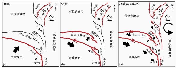
除此之外,另一个关键的部位就是青藏高原东北缘的弧形构造带,这个位置主要包括了海原断裂带、香山-天景山断裂带和三关口-牛首山断裂带3个主要的弧形断裂系[42, 80, 86]( 图 8)。综合活动断裂、新生代地层与低温热年代学的研究结果[42, 69, 70, 77, 79, 96, 104],我们发现,海原断裂带在约10Ma开始的逆冲,导致了其东端部六盘山的快速隆升,后期断裂性质转变为左旋走滑,新生代地层及构造变形结果给出的其左旋走滑开始时间大约是在5.4Ma,而此时北侧的香山-天景山断裂开始逆冲活动,约2.6Ma(或约2.7Ma)香山-天景山断裂由逆冲转化为左旋运动,而其北侧的三关口-牛首山断裂附近受挤压开始褶皱变形[70, 104],在三关口-牛首山断裂带附近野外调查发现形成于上新世末的先存褶皱构造被断裂错断异位表明断裂的右旋走滑不早于上新世末,并由此利用最大位移和平均滑动速率估算的断裂起始右旋走滑时间在约2.7Ma之后[86],说明三关口-牛首山断裂带已成为青藏高原与华北地块(鄂尔多斯地块)之间的最新构造边界,也是高原向外扩展的东北部最前缘(图 8)。
|
图 8 青藏高原东北缘弧形构造带向外生长扩展过程 修改于文献[86] Fig. 8 Outward growth pattern of arc-shaped tectonic zone in the NE Tibetan Plateau, modified from reference[86] |
近几十年活动构造运动特征和定量研究结果表明,青藏高原东北缘发育有近东西向-北东东向的大型左旋走滑断裂带(包括了祁连-海原断裂、阿尔金断裂等)、北西西向的逆冲断裂带(包括了祁连山内部及边缘断裂、河西走廊内部及边缘断裂和六盘山断裂等)及北北西向的右旋走滑断裂带(主要是鄂拉山断裂与拉脊山断裂),在以上这3组主要断裂的控制下,青藏高原东北缘的祁连山呈现出山体两侧向山前盆地双向逆冲、山体内部发育走滑断裂、走滑断裂在端部转换为地壳缩短的特征。各组断裂的运动学性质存在明显的差异,其中左旋走滑的主边界断裂一般表现为中间稳定向两边逐渐降低的水平走滑运动性质,在区域构造运动转换过程中起着控制性作用,而北西西向的逆冲断裂滑动速率一般小于1mm/a,多发育在大型走滑断裂的端部,起着调节和吸收大型走滑断裂端部水平滑动的作用,同时进一步证明了走滑断裂端部滑动速率的降低一般是通过端部山脉隆起、盆地变形和逆冲断裂所吸收和转换;而祁连山南部北北西的右旋走滑断裂主要是起到不同块体差异运动过程中的运动调节作用。青藏高原东北缘不同位置的活动构造,通过不同的运动性质、不同变形方式、不同的转换关系构成了青藏高原东北缘构造变形的总体几何图像和运动图像。青藏高原东北缘活动构造的发育、形成和生长扩展过程控制着现今的构造变形和演化历史。受印度板块与欧亚板块碰撞后向北的推挤过程,青藏高原东北缘的构造发育基本上遵循了由南向北(或北东)扩展的过程,在不同阶段不同位置的断裂开始发育、生长和发生性质转换,逐步形成了青藏高原东北缘的现今构造格架。高原边缘扩展的时空序列显示,高原边缘在新生代晚期发生了迁移,在河西走廊地区已越过河西走廊到达阿拉善地块南部边缘,而在东北缘弧形构造带的位置,其边缘也已经到达了三关口-牛首山断裂一带,形成了新的高原隆升和扩展的边界。
致谢: 本文是在前人大量研究基础上一个总结,在此对致力于青藏高原研究的各位前辈、同仁表达最崇高的敬意和深切的谢意;匿名审稿人对论文的修改和完善提出了建设性意见,在此真挚地表示感谢!
| 1 |
Tapponnier P, Meyer B, Avounc J P, et al. Active thrusting and folding in the Qilian Shan, and decoupling between upper crust and mantle in the northeastern Tibet.
Earth and Planetary Science Letters,1990, 97 (3) : 382~403.
( 0) 0)
|
| 2 |
Tapponnier P, Xu Z, Roger F, et al. Oblique stepwise rise and growth of the Tibet Plateau.
Science,2001, 294 (5574) : 1671~1677.
( 0) 0)
|
| 3 |
Meyer B, Tapponnier P, Bourjot L, et al. Crustal thickening in Gansu-Qinghai, lithospheric mantle subduction, and oblique, strike-slip controlled growth of the Tibet Plateau.
Geophysical Journal International,1998, 135 (1) : 1~47.
( 0) 0)
|
| 4 |
Palumbo L, Hetzel R, Tao M, et al. Deciphering the rate of mountain growth during topographic presteady state:An example from the NE margin of the Tibetan Plateau.
Tectonics,2009, 28 (4) : TC4017.
doi: 10.1029/2009TC002455 ( 0) 0)
|
| 5 |
Zheng Wenjun, Zhang Peizhen, He Wengui, et al. Transformation of displacement between strike-slip and crustal shortening in the northern margin of the Tibetan Plateau:Evidence from decadal GPS measurements and Late Quaternary slip rates on faults.
Tectonophysics,2013, 584 : 267~280.
( 0) 0)
|
| 6 |
Zheng Wenjun, Zhang Peizhen, Ge Weipeng, et al. Late Quaternary slip rate of the South Heli Shan Fault(Northern Hexi corridor, NW China)and its implications for north-eastward growth of the Tibetan Plateau.
Tectonics,2013, 32 (2) : 271~293.
( 0) 0)
|
| 7 |
Hetzel R. Active faulting, mountain growth, and erosion at the margins of the Tibetan Plateau constrained by in situ-produced cosmogenic nuclides.
Tectonophysics,2013, 582 : 1~24.
( 0) 0)
|
| 8 |
Yuan Daoyang, Ge Weipeng, Chen Zhenwei, et al. The growth of northeastern Tibet and its relevance to large-scale continental geodynamics:A review of recent studies.
Tectonics,2013, 32 (5) : 1358~1370.
( 0) 0)
|
| 9 |
张培震, 邓起东, 张国民, 等. 中国大陆的强震活动与活动地块.
中国科学(D辑),2003, 46 (Suppl.) : 13~24.
Zhang Peizhen, Deng Qidong, Zhang Guomin, et al. Active tectonic blocks and strong earthquakes in the continent of China. Science in China(Series D),2003, 46 (Suppl.) : 13~24. (  0) 0)
|
| 10 |
李有利, 谭利华, 段烽军, 等. 甘肃酒泉盆地河流地貌与新构造运动.
干旱区地理,2000, 23 (4) : 304~308.
Li Youli, Tan Lihua, Duan Fengjun, et al. Response of alluvial landforms to neotectonics in the Jiuquan Basin, Gansu, Northwest China. Arid Land Geography,2000, 23 (4) : 304~308. (  0) 0)
|
| 11 |
杨景春, 谭利华, 李有利, 等. 祁连山北麓河流阶地与新构造演化.
第四纪研究,1998 (3) : 229~237.
Yang Jingchun, Tan Lihua, Li Youli, et al. River terraces and neotectonic evolution at north margin of the Qilianshan Mountains. Quaternary Sciences,1998 (3) : 229~237. (  0) 0)
|
| 12 |
Pan Baotian, Geng Haopeng, Hu Xiaofei, et al. The topographic controls on the decadal-scale erosion rates in Qilian Shan Mountains, N. W. China.
Earth and Planetary Science Letters,2010, 292 (1-2) : 148~157.
( 0) 0)
|
| 13 |
Zhang Huiping, Zhang Peizhen, Zheng Dewen, et al. Transforming the Miocene Altyn Tagh Fault slip into shortening of the north-western Qilian Shan:Insights from the drainage basin geometry.
Terra Nova,2014, 26 (3) : 216~221.
( 0) 0)
|
| 14 |
王一舟, 张会平, 俞晶星, 等. 祁连山洪水坝河流域地貌特征及其构造意义.
第四纪研究,2013, 33 (4) : 734~745.
Wang Yizhou, Zhang Huiping, Yu Jingxing, et al. Geomorphic features of the Hongshuiba River drainage basin in Qilianshan Mountain and its insight into tectonic implications. Quaternary Sciences,2013, 33 (4) : 734~745. (  0) 0)
|
| 15 |
Wang Yizhou, Zhang Huiping, Zheng Dewen, et al. Controls on decadal erosion rates in Qilian Shan:Re-evaluation and new insights into landscape evolution in north-east Tibet.
Geomorphology,2014, 223 : 117~128.
( 0) 0)
|
| 16 |
苏琦, 袁道阳, 谢虹, 等. 祁连山西段党河流域地貌特征及其构造指示意义.
第四纪研究,2015, 35 (1) : 48~59.
Su Qi, Yuan Daoyang, Xie Hong, et al. Geomorphic features of the Danghe River drainage basin in western Qilian Shan Mountain and its tectonic implications. Quaternary Sciences,2015, 35 (1) : 48~59. (  0) 0)
|
| 17 |
张会平, 张培震, 郑德文, 等. 祁连山构造地貌特征:青藏高原东北缘晚新生代构造变形和地貌演化过程的启示.
第四纪研究,2012, 32 (5) : 907~920.
Zhang Huiping, Zhang Peizhen, Zheng Dewen, et al. Tectonic geomorphology of the Qilian Shan:Insights into the Late Cenozoic landscape evolution and deformation in the norht eastern Tibetan Plateau. Quaternary Sciences,2012, 32 (5) : 907~920. (  0) 0)
|
| 18 |
邓起东, 张培震, 冉勇康, 等. 中国大陆活动构造基本特征.
中国科学(D),2002, 32 (12) : 1020~1030.
Deng Qidong, Zhang Peizhen, Ran Yongkang, et al. Basic characteristics of active tectonics of China. Science in China(Series D),2002, 32 (12) : 1020~1030. (  0) 0)
|
| 19 |
方小敏, 赵志军, 李吉均, 等. 祁连山北缘老君庙背斜晚新生代磁性地层与高原北部隆升.
中国科学(D辑),2005, 48 (7) : 1040~1051.
Fang Xiaomin, Zhao Zhijun, Li Jijun, et al. Magnetostratigraphy of the Late Cenozoic Laojunmiao anticline in the northern Qilian Mountains and its implications for the northern Tibetan Plateau uplift. Science in China(Series D),2005, 48 (7) : 1040~1051. (  0) 0)
|
| 20 |
张培震, 邓起东, 张竹琪, 等. 中国大陆的活动断裂、地震灾害及其动力过程.
中国科学:地球科学,2013, 43 (10) : 1607~1620.
Zhang Peizhen, Deng Qidong, Zhang Zhuqi, et al. Active faults, earthquake hazards and associated geodynamic processes in continental China. Science China: Earth Sciences,2013, 43 (10) : 1607~1620. (  0) 0)
|
| 21 |
张培震, 张会平, 郑文俊, 等. 东亚大陆新生代构造演化.
地震地质,2014, 36 (3) : 574~585.
Zhang Peizhen, Zhang Huiping, Zheng Wenjun, et al. Cenozoic tectonic evolution of continental Eastern Asia. Seismology and Geology,2014, 36 (3) : 574~585. (  0) 0)
|
| 22 |
Hetzel R, Niedermann S, Tao M, et al. Low slip rates and long-term preservation of geomorphic features in Central Asia.
Nature,2002, 417 : 428~432.
( 0) 0)
|
| 23 |
Hetzel R, Tao M, Stokes S, et al. Late Pleistocene/Holocene slip rate of the Zhangye thrust(Qilian Shan, China)and implications for the active growth of the northeastern Tibetan Plateau.
Tectonics,2004, 23 (6) : 1~17.
( 0) 0)
|
| 24 |
Zhang Peizhen, Molnar P, Xu Xiwei. Late Quaternary and present-day rates of slip along the Altyn Tagh Fault, northern margin of the Tibetan Plateau.
Tectonics,2007, 26 (5) : 1~24.
( 0) 0)
|
| 25 |
Li Jijun, Wen Shixuan, Zhang Qingsong, et al. A discussion on the period, amplitude and type of the uplift of the Qinghai-Xizang Plateau.
Scientia Sinica,1979, 22 (11) : 1314~1328.
( 0) 0)
|
| 26 |
Molnar P, Tapponnier P. Cenozoic tectonics of Asia:Effects of a continental collision.
Science,1975, 189 (4201) : 419~426.
( 0) 0)
|
| 27 |
Molnar P, England P, Martinod J. Mantle dynamics, uplift of the Tibetan Plateau, and the Indian monsoon.
Reviews of Geophysics,1993, 31 (4) : 357~396.
( 0) 0)
|
| 28 |
Molnar P, Stock J M. Slowing of India's convergence with Eurasia since 20Ma and its implications for Tibetan mantle dynamics.
Tectonics,2009, 28 (3) : 1~11(TC3001).
( 0) 0)
|
| 29 |
An Zhisheng, Kutzbach J E, Prell W L, et al. Evolution of Asian monsoons and phased uplift of the Himalaya-Tibetan Plateau since Late Miocene times.
Nature,2001, 411 : 62~66.
( 0) 0)
|
| 30 |
Zhang Peizhen, Molnar P, Downs W. Increased sedimentation rates and grain sizes 2-4Myr ago due to the influence of climate changes on erosion rates.
Nature,2001, 410 : 891~897.
( 0) 0)
|
| 31 |
李吉均, 方小敏, 潘保田, 等. 新生代晚期青藏高原强烈隆起及其对周边环境的影响.
第四纪研究,2001, 21 (5) : 381~391.
Li Jijun, Fang Xiaomin, Pan Baotian, et al. Late Cenozoic intensive uplift of Qinghai-Xizang Plateau and its impacts on environments in surrounding area. Quaternary Sciences,2001, 21 (5) : 381~391. (  0) 0)
|
| 32 |
赵秀丽, 张春霞, 吴海斌, 等. 西宁盆地始新世/渐新世过渡期孢粉植物群特征及其意义.
第四纪研究,2015, 35 (6) : 1489~1499.
Zhao Xiuli, Zhang Chunxia, Wu Haibin, et al. Significance of Eocene-Oligocene transition pollen record from Xining Basin, China. Quaternary Sciences,2015, 35 (6) : 1489~1499. (  0) 0)
|
| 33 |
滕晓华, 韩文霞, 叶程程, 等. 柴达木盆地SG-1孔1.0Ma以来碳酸盐同位素记录的亚洲内陆干旱化及成因.
第四纪研究,2013, 33 (5) : 866~875.
Teng Xiaohua, Han Wenxia, Ye Chengcheng, et al. Aridification of the Asian inland since 1.0Ma:Evidences from carbonate isotope records of deep core from the Qaidam Basin. Quaternary Sciences,2013, 33 (5) : 866~875. (  0) 0)
|
| 34 |
脱世博, 方小敏, 宋春晖, 等. 青藏高原东北部西宁盆地晚渐新世-早中新世沉积物岩石磁学特征及其古环境意义.
第四纪研究,2013, 33 (5) : 829~838.
Tuo Shibo, Fang Xiaomin, Song Chunhui, et al. Rock magnetic characteristics of the Late Oligocene to Early Miocene sediments in the Xining Basin, northeastern Tibetan Plateau. Quaternary Sciences,2013, 33 (5) : 829~838. (  0) 0)
|
| 35 |
Xu Xiwei, Yeats R S, Yu Guihua. Five short historical earthquake surface ruptures near the Silk Road, Gansu Province, China.
Bulletin of the Seismological Society of America,2010, 100 (2) : 541~561.
( 0) 0)
|
| 36 |
郑文俊, 张竹琪, 张培震, 等. 1954年山丹71/4级地震的孕震构造和发震机制探讨.
地球物理学报,2013, 56 (3) : 916~928.
Zheng Wenjun, Zhang Zhuqi, Zhang Peizhen, et al. Seismogenic structure and mechanism of the 1954 M71/4 Shandan Earthquake, Gansu Province, Western China. Chinese Journal of Geophysics,2013, 56 (3) : 916~928. (  0) 0)
|
| 37 |
邓起东, 陈立春, 冉勇康. 活动构造定量研究与应用.
地学前缘,2004, 11 (4) : 383~392.
Deng Qidong, Chen Lichun, Ran Yongkang. Quantitative studies and applications of active tectonics. Earth Science Frontiers,2004, 11 (4) : 383~392. (  0) 0)
|
| 38 |
丁国瑜, 田勤俭, 孔凡臣, 等.
活断层分段原则、方法及应用 . 北京: 地震出版社, 1993 : 39 ~76.
( 0) 0)
|
| 39 |
Crone A J, Haller K M. Segmentation and the coseismic behavior of basin and range normal faults:Examples from east-central Idaho and southwestern Mon-tana, U.S.A.
Journal of Structural Geology,1991, 13 (2) : 151~164.
( 0) 0)
|
| 40 |
Machette N M, Personius S F, Nelson A R, et al. The Wasatch fault zone, Utah-segmentation and history of Holocene earthquake.
Journal of Structural Geology,1991, 13 (2) : 137~149.
( 0) 0)
|
| 41 |
Mccalpin J P. Trench technology. In:The Workshop of Paleoseismology on30th IGC. Beijing:1996. 86~111
( 0) 0)
|
| 42 |
Zhang Peizhen, Burchfiel B C, Molnar P, et al. Rate, amount, and style of Late Cenozoic deformation of southern Ningxia, northeastern margin of Tibetan Plateau.
Tectonics,1991, 10 : 1111~1129.
( 0) 0)
|
| 43 |
Zheng Wenjun, Zhang Huiping, Zhang Peizhen, et al. Late Quaternary slip rates of the thrust faults in western Hexi Corridor(Northern Qilian Shan, China)and their implications for northeastward growth of the Tibetan Plateau.
Geosphere,2013, 9 (2) : 342~354.
( 0) 0)
|
| 44 |
Li Chuanyou, Zhang Peizhen, Yin Jinhui, et al. Late Quaternary left-lateral slip rate of the Haiyuan Fault, northeastern margin of the Tibetan Plateau.
Tectonics,2008, 28 : 1~26(TC5010).
( 0) 0)
|
| 45 |
Kirby E, Harkins N, Wang Erqi, et al. Slip rate gradients along the eastern Kunlun Fault.
Tectonics,2007, 26 (2) : 1~16.
( 0) 0)
|
| 46 |
Duvall A R, Clark M K. Dissipation of fast strike-slip faulting within and beyond northeastern Tibet.
Geology,2010, 38 (3) : 223~226.
( 0) 0)
|
| 47 |
Cowgill E, Gold R D, Chen Xuanhua, et al. Low Quaternary slip rate reconciles geodetic and geologic rates along the Altyn Tagh Fault, northwestern Tibet.
Geology,2009, 37 (7) : 647~650.
( 0) 0)
|
| 48 |
Yin A, Rumelhart P E, Butler R, et al. Tectonic history of the Altyn Tagh Fault system in northern Tibet inferred from Cenozoic sedimentation.
Geological Society of American Bulletin,2002, 114 (10) : 1257~1295.
( 0) 0)
|
| 49 |
Yin A, Dang Y, Zhang M, et al. Cenozoic tectonic evolution of Qaidam Basin and its surrounding regions(Part 2):Wedge tectonics in southern Qaidam Basin and the eastern Kunlun range.
Geological Society of America (Special Paper),2007, 433 : 369~390.
( 0) 0)
|
| 50 |
Yin A, Dang Y, Wang L, et al. Cenozoic tectonic evolution of Qaidam Basin and its surrounding regions(Part 1):The southern Qilian Shan-Nan Shan thrust belt and northern Qaidam Basin.
Geological Society of America Bulletin,2008, 120 (7/8) : 813~846.
( 0) 0)
|
| 51 |
Yin A, Dang Y, Zhang M, et al. Cenozoic tectonic evolution of the Qaidam Basin and its surrounding regions(Part3):Structural geology, sedimentation, and regional tectonic reconstruction.
Geological Society of America Bulletin,2008, 120 (7/8) : 847~876.
( 0) 0)
|
| 52 |
袁道阳, 张培震, 刘百篪, 等. 青藏高原东北缘晚第四纪活动构造研究的几何图像与构造转换.
地质学报,2004, 78 (2) : 270~278.
Yuan Daoyang, Zhang Peizhen, Liu Baichi, et al. Geometrical imagery and tectonic transformation of Late Quaternary active tectonics in northeastern margin of Qinghai-Xizang Plateau. Acta Geologica Sinica,2004, 78 (2) : 270~278. (  0) 0)
|
| 53 |
Yuan Daoyang, Champagnac J D, Ge Weipeng, et al. Late Quaternary right-lateral slip rates of active faults adjacent to Lake Qinghai, northeastern margin of the Tibetan Plateau.
Geological Society of American Bulletin,2011, 123 (9-10) : 2016~2030.
( 0) 0)
|
| 54 |
向宏发, 虢顺民, 张秉良, 等. 六盘山东麓活动逆断裂构造带晚第四纪以来的活动特征.
地震地质,1998, 20 (4) : 321~327.
Xiang Hongfa, Guo Shunmin, Zhang Bingliang, et al. Active features of the eastern Liupanshan piedmont reverse fault zone since Late Quaternary. Seismology and Geology,1998, 20 (4) : 321~327. (  0) 0)
|
| 55 |
李传友.青藏高原东北部几条主要断裂带的定量研究.北京:中国地震局地质研究所博士学位论文, 2005. 14~113
Li Chuanyou. Quantitative Studies on Major Active Fault Zones in Northeastern Qinghai-Tibet Plateau. Beijing:The Ph.D Thesis of Institute of Geology, China Earthquake Administration, 2005. 14~113 (  0) 0)
|
| 56 |
郑文俊, 张培震, 袁道阳, 等. GPS观测及断裂晚第四纪滑动速率所反映的青藏高原北部变形.
地球物理学报,2009, 52 (10) : 2491~2508.
Zheng Wenjun, Zhang Peizhen, Yuan Daoyang, et al. Deformation on the northern of the Tibetan Plateau from GPS measurement and geologic rates of Late Quaternary along the major fault. Chinese Journal of Geophysics,2009, 52 (10) : 2491~2508. (  0) 0)
|
| 57 |
Wang Q, Zhang P Z, Freymueller J T, et al. Present-day crustal deformation in China constrained by global positioning system(GPS)measurements.
Science,2001, 294 (5542) : 574~577.
( 0) 0)
|
| 58 |
Zhang Peizhen, Shen Zhenkang, Wang Min, et al. Continuous deformation of the Tibetan Plateau from global positioning system data.
Geology,2004, 32 (9) : 809~812.
( 0) 0)
|
| 59 |
Kirby E, Harkins N. Distributed deformation around the eastern tip of the Kunlun fault.
International Journal of Earth Sciences,2013, 102 (7) : 1759~1772.
doi: 10.1007/s00531-013-0872-x ( 0) 0)
|
| 60 |
张会平, 张培震, 袁道阳. 南北地震带中段地貌发育差异性及其与西秦岭构造带关系初探.
第四纪研究,2010, 30 (4) : 803~811.
Zhang Huiping, Zhang Peizhen, Yuan Daoyang. Differential landscape development of the central N-S Seismic Zone and its relation to the west Qinling tectonic belt. Quaternary Sciences,2010, 30 (4) : 803~811. (  0) 0)
|
| 61 |
郑文俊, 袁道阳, 何文贵, 等. 甘肃东南地区构造活动与2013年岷县-漳县Ms6.6级地震孕震机制.
地球物理学报,2013, 56 (12) : 4058~4071.
Zheng Wenjun, Yuan Daoyang, He Wengui, et al. Geometric pattern and active tectonics in southeastern Gansu Province:Discussion on seismogenic mechanism of the Minxian-Zhangxian Ms6.6 earthquake on July 22, 2013. Chinese Journal of Geophysics,2013, 56 (12) : 4058~4071. (  0) 0)
|
| 62 |
Ren Junjie, Xu Xiwei, Yeats R S, et al. Latest Quaternary paleoseismology and slip rates of the Longriba Fault zone, eastern Tibet:Implications for fault behavior and strain partitioning.
Tectonics,2013, 32 (2) : 216~238.
( 0) 0)
|
| 63 |
贾伟, 刘洪春, 柳煜, 等. 武都-康县断裂带活动性初步研究.
西北地震学报,2012, 34 (2) : 142~148.
Jia Wei, Liu Hongchun, Liu Yu, et al. Preliminary study on activity of the Wudu-Kangxian Fault zone. Northwestern Seismological Journal,2012, 34 (2) : 142~148. (  0) 0)
|
| 64 |
俞晶星, 郑文俊, 袁道阳, 等. 西秦岭西段光盖山-迭山断裂带坪定-化马断裂的新活动与运动特征.
第四纪研究,2012, 32 (5) : 957~967.
Yu Jingxing, Zheng Wenjun, Yuan Daoyang, et al. Late Quaternary active characteristics and slip-rate of Pingding-Huama Fault, the eastern segment of Guanggaishan-Dieshan Fault zone(west Qinling Mountain). Quaternary Sciences,2012, 32 (5) : 957~967. (  0) 0)
|
| 65 |
Zheng Wenjun, Liu Xingwang, Yu Jingxing et al. Geometry and Late Pleistocene slip rates of the Liangdang-Jiangluo Fault in the western Qinling Mountains, NW China. Tectonophysics, 2016(In press)
( 0) 0)
|
| 66 |
袁道阳, 雷中生, 何文贵, 等. 公元前186年甘肃武都地震考证与发震构造探讨.
地震学报,2007, 29 (6) : 654~663.
Yuan Daoyang, Lei Zhongsheng, He Wengui, et al. Textual research of Wudu earthquake in 186 B. C. in Gansu Province, China and discussion on its causative structure. Acta Seismologica Sinica,2007, 29 (6) : 654~663. (  0) 0)
|
| 67 |
张国伟, 孟庆任, 赖绍聪. 秦岭造山带的结构构造.
中国科学(B辑),1995, 25 (9) : 994~1003.
Zhang Guowei, Meng Qingren, Lai Shaocong. Structure of the Qinling orogen. Science in China(Series B),1995, 25 (9) : 994~1003. (  0) 0)
|
| 68 |
张国伟, 郭安林, 姚安平. 中国大陆构造中的西秦岭-松潘大陆构造结.
地学前缘,2004, 11 (3) : 23~32.
Zhang Guowei, Guo Anlin, Yao Anping. Western Qinling-Songpan continental tectonic node in China's continental tectonics. Earth Science Frontier,2004, 11 (3) : 23~32. (  0) 0)
|
| 69 |
Zheng Dewen, Zhang Peizhen, Wan Jingling, et al. Rapid exhumation at-8Ma on the Liupanshan thrust from apatite fission-track thermochronology:Implications for growth of the northeastern Tibetan Plateau margin.
Earth and Planetary Science letters,2006, 248 (1-2) : 183~193.
( 0) 0)
|
| 70 |
Wang Weitao, Kirby Eric, Zhang Peizhen, et al. Tertiary basin evolution along the northeastern margin of the Tibetan Plateau:Evidence for basin formation during Oligocene transtension.
Geological Society of America Bulletin,2013, 125 (3/4) : 377~400.
( 0) 0)
|
| 71 |
李小强, 任金卫, 杨攀新, 等. 六盘山东西两侧第四纪以来构造差异隆升速率递变性.
第四纪研究,2015, 35 (2) : 445~452.
Li Xiaoqiang, Ren Jinwei, Yang Panxin, et al. Regularity of tectonic differential uplifting rates of both the east and west sides of Liupanshan Mountain since the Quaternary. Quaternary Sciences,2015, 35 (2) : 445~452. (  0) 0)
|
| 72 |
孙昭民, 邓起东.
六盘山东麓断裂和陇县-宝鸡断裂基本特征及其相互关系.见:中国地震学会编.中国活动断层研究 . 北京: 地震出版社, 1994 : 114 ~125.
Sun Zhaomin, Deng Qidong. Basic characteristics and interaction of the eastern Liupanshan piedmont fault and the Longxian-Baoji Fault zone. In:Sesimological Society of China ed. The Active Fault Research in China. Beijing: Seismological Press, 1994 : 114 ~125. (  0) 0)
|
| 73 |
史志刚, 李廷栋, 袁道阳, 等. 六盘山东东麓断裂南段断裂沟槽韵律沉积特征对最新活动时代的限定.
地球学报,2014, 35 (1) : 31~37.
Shi Zhigang, Li Tingdong, Yuan Daoyang, et al. The recent time of the south segment of the eastern Liupanshan piedmont fault:Constraints from the characteristics of rhythmic deposits in the fault grooves. Acta Geoscientica Sinica,2014, 35 (1) : 31~37. (  0) 0)
|
| 74 |
史志刚.六盘山地区断裂新活动特征与大震危险性趋势判定.兰州:中国地震局兰州地震研究所硕士学位论文, 2011.5~58
Shi Zhigang. The Recent Activity Features and Risk Trend of Strong Earthquake in Liupanshan Region. Lanzhou:The Thesis for Master's Degree of Lanzhou Institute of Seismology, 2011.5~58 (  0) 0)
|
| 75 |
刘兴旺, 袁道阳, 史志刚, 等. 六盘山断裂带构造活动特征及流域盆地地貌响应.
地震工程学报,2015 (1) : 168~174.
Liu Xingwang, Yuan Daoyang, Shi Zhigang, et al. Tectonic activity characteristics of the Liupanshan Fault zone and geomorphologic response of drainage basin. China Earthquake Engineering Journal,2015 (1) : 168~174. (  0) 0)
|
| 76 |
国家地震局"鄂尔多斯活动断裂系"课题组.
鄂尔多斯周缘活动断裂系 . 北京: 地震出版社, 1988 : 1 ~322.
Research Group on Active Fault Systems around the Ordos Massif, State Seismological Bureau. Active Fault Systems around the Ordos Massif. Beijing: Seismological Press, 1988 : 1 ~322. (  0) 0)
|
| 77 |
国家地震局地质研究所, 宁夏回族自治区地震局.
海原断裂带 . 北京: 地震出版社, 1990 : 1 ~278.
Institute of Geology, China Earthquake Administration, Earthquake Bureau of Ningxia Hui Autonomous Region. The Haiyuan Fautl Zone. Beijing: Seismological Press, 1990 : 1 ~278. (  0) 0)
|
| 78 |
柴炽章, 孟广魁, 马贵仁.
银川市活断层探测与地震危险性评价 . 北京: 科学出版社, 2011 : 28 ~30.
Chai Chizhang, Meng Guangkui, Ma Guiren. Active Faults Exploration and Seismic Hazard Assessment in Yinchuan City. Beijing: Science Press, 2011 : 28 ~30. (  0) 0)
|
| 79 |
王伟涛, 张培震, 雷启云. 牛首山-罗山断裂带的变形特征及其构造意义.
地震地质,2013, 35 (2) : 195~207.
Wang Weitao, Zhang Peizhen, Lei Qiyun. Deformational characteristics of the Niushoushan-Luoshan Fault zone and its tectonic implications. Seismology and Geology,2013, 35 (2) : 195~207. (  0) 0)
|
| 80 |
霍福臣, 潘行适, 尤国林.
宁夏地质概论 . 北京: 科学出版社, 1989 : 1 ~300.
Huo Fucheng, Pan Xingshi, You Guolin. Introduction to Geology of Ningxia. Beijing: Science Press, 1989 : 1 ~300. (  0) 0)
|
| 81 |
汤锡元, 冯乔, 李道燧. 内蒙古西部巴彦浩特盆地的构造特征及其演化.
石油与天然气地质,1990, 11 (2) : 127~135.
Tang Xiyuan, Feng Qiao, Li Daosui. Tectonic characteristics and evolution of Bayanhot Basin, western Inner Mongolia. Oil and Gas Geology,1990, 11 (2) : 127~135. (  0) 0)
|
| 82 |
李克勤.
中国石油地质志(卷十二) . 北京: 石油工业出版社, 1992 : 362 ~371.
Li Keqin. Petroleum Geology of China(Vo1.12). Beijing: Petroleum Industry Press, 1992 : 362 ~371. (  0) 0)
|
| 83 |
张进, 马宗晋, 任文军. 贺兰山南部构造特征及其与固原-青铜峡断裂的关系.
吉林大学学报(地球科学版),2004, 34 (2) : 187~205.
Zhang Jin, Ma Zongjin, Ren Wenjun. The tectonic characteristics of southern Helan Mountain and their relationships with the Guyuan-Qingtongxia Fault. Journal of Jilin University (Earth Science Edition),2004, 34 (2) : 187~205. (  0) 0)
|
| 84 |
Zhang Jin, Cunningham D, Chen H Y. Sedimentary characteristics of Cenozoic strata in central-southern Ningxia, NW China:Implications for the evolution of the NE Qinghai-Tibetan Plateau.
Journal of Asian Earth Sciences,2010, 39 (6) : 740~749.
( 0) 0)
|
| 85 |
Min Wei, Jiao Dechen, Chai Chizhang, et al. Characteristics of the active Luoshan Fault since Late Pleistocene, north Central China.
Annals Geophysics,2003, 46 (5) : 997~1014.
( 0) 0)
|
| 86 |
雷启云, 张培震, 郑文俊, 等. 青藏高原东北缘三关口-牛首山断裂的右旋走滑与弧形构造带扩展.
中国科学:地球科学,2016, 59 (5) : 1025~1040.
Lei Qiyun, Zhang Peizhen, Zheng Wenjun, et al. Dextral strike-slip of Sanguankou-Niushoushan Fault zone and extension of arc tectonic belt in the northeastern margin of the Tibet Plateau. Science China:Earth Sciences,2016, 59 (5) : 1025~1040. (  0) 0)
|
| 87 |
Yu Jingxing, Zheng Wenjun, Kirby E, et al. Kinematics of Late Quaternary slip along the Yabrai Fault:Implications for Cenozoic tectonics across the Gobi Alashan block, China.
Lithosphere,2016, 8 (3) : 199~218.
doi: 10.1130/L509.1 ( 0) 0)
|
| 88 |
郑文俊.河西走廊及其邻区活动构造图像及构造变形模式.北京:中国地震局地质研究所博士学位论文, 2009. 84~140
Zheng Wenjun. Geometric Pattern and Active Tectonics of the Hexi Corridor and Its Adjacent Regions. Beijing:The Ph.D Thesis of Institute of Geology, China Earthquake Administration, 2009. 84~140 (  0) 0)
|
| 89 |
俞晶星, 郑文俊, 雷启云, 等. 阿拉善地块南部雅布赖山前断裂的运动学特征及意义.
地震地质,2013, 35 (4) : 731~744.
Yu Jingxing, Zheng Wenjun, Lei Qiyun, et al. Neotectonics and kinematics along the Yabrai range-front fault in the south Alashan block and its implications for regional tectonics. Seismology and Geology,2013, 35 (4) : 731~744. (  0) 0)
|
| 90 |
Zheng Wenjun, Zhang Peizhen, Yuan Daoyang, et al. Discovery of surface rupture zone on the south of Helishan in Gaotai, Gansu Province.
Earthquake Research in China,2010, 24 (1) : 97~105.
( 0) 0)
|
| 91 |
国家地震局地质研究所, 国家地震局兰州地震研究所.
祁连山-河西走廊活动断裂系 . 北京: 地震出版社, 1993 : 148 ~174.
Institute of Geology, China Earthquake Administration, Lanzhou Institute of Seismology, China Earthquake Administration. The Qilian Mountain-Hexi Corridor Active Fault System. Beijing: Seismological Publishing House, 1993 : 148 ~174. (  0) 0)
|
| 92 |
Tapponnier P, Molnar P. Slip-line field theory and large-scale continental tectonics.
Nature,1976, 264 : 319~324.
( 0) 0)
|
| 93 |
Tapponnier P, Peltzer G, Le Dain A Y, et al. Propagating extrusion tectonics in Asia:New insights from experiments with plasticine.
Geology,1982, 10 (12) : 611~616.
( 0) 0)
|
| 94 |
Peltzer G, Tapponnier P, Armijo R. Magnitude of Late Quaternary left-lateral displacements along the north edge of Tibet.
Science,1989, 246 (4935) : 1285~1289.
( 0) 0)
|
| 95 |
Replumaz A, Tapponnier P. Reconstruction of the deformed collision zone between India and Asia by backward motion of lithospheric blocks.
Journal of Geophysical Research,2003, 108 (B6) : 2285.
( 0) 0)
|
| 96 |
Burchfiel B C, Zhang P, Wang Y, et al. Geology of the Haiyuan Fault zone, Ningxia Autonomous Region, China and its relation to the evolution of the northeastern margin of the Tibetan Plateau.
Tectonics,1991, 10 : 1091~1110.
( 0) 0)
|
| 97 |
England P, Molnar P. Active deformation of Asia:From kinematics to dynamics.
Science,1997, 278 (5338) : 647~650.
( 0) 0)
|
| 98 |
张宁, 郑文俊, 刘兴旺, 等. 河西走廊西端黑山断裂运动学特征及其在构造转换中的意义.
地球科学与环境学报,2016, 38 (2) : 245~257.
Zhang Ning, Zheng Wenjun, Liu Xingwang, et al. Kinematics characteristics of Heishan Fault in the western Hexi Corridor and its implications for regional tectonic transformation. Journal of Earth Sciences and Environment,2016, 38 (2) : 245~257. (  0) 0)
|
| 99 |
徐锡伟, TapponnierP, vanDer Worerd J, 等. 阿尔金断裂带晚第四纪左旋走滑速率及其构造运动转换模式讨论.
中国科学(D辑),2003, 33 (10) : 967~974.
Xu Xiwei, Tapponnier P, van Der Worerd J, et al. Late Quaternary sinistral slip rate along the Altyn Tagh Fault and its structural transformational model. Science in China(Series D),2003, 33 (10) : 967~974. (  0) 0)
|
| 100 |
高锐, 成湘洲, 丁谦. 格尔木-额济纳旗地学断面地球动力学模型初探.
地球物理学报,1995, 38 (S2) : 3~14.
Gao Rui, Cheng Xiangzhou, Ding Qian. Preliminary geodynamic model of Golmud-Ejin Qi geoscience transect. Chinese Journal of Geophysics,1995, 38 (S2) : 3~14. (  0) 0)
|
| 101 |
Xiao Qibin, Zhang Jing, Wang Jijun et al. Electrical resistivity structures between the northern Qilian Mountains and Beishan Block, NW China, and tectonic implications. Physics of the Earth and Planetary Interiors, 2012, 200~201 :92~104
( 0) 0)
|
| 102 |
Zheng Dewen, Clark M K, Zhang Peizhen, et al. Erosion, fault initiation and topographic growth of the north Qilian Shan(northern Tibetan Plateau).
Geosphere,2010, 6 (6) : 937~941.
( 0) 0)
|
| 103 |
万景林, 郑文俊, 郑德文, 等. 祁连山北缘晚新生代构造活动的低温热年代学证据.
地球化学,2010, 39 (5) : 439~446.
Wan Jinglin, Zheng Wenjun, Zheng Dewen, et al. Low closure temperature thermochronometry study on the Late Cenozoic tectonic active of northern Qilianshan and its implication for dynamics of Tibetan Plateau growth. Geochimica,2010, 39 (5) : 439~446. (  0) 0)
|
| 104 |
Wang Weitao, Zhang Peizhen, Kirby E, et al. A revised chronology for Tertiary sedimentation in the Sikouzi Basin:Implications for the tectonic evolution of the northeastern corner of the Tibetan Plateau.
Tectonophysics,2011, 505 : 100~114.
( 0) 0)
|
②. Lanzhou Institute of Seismology, China Earthquake Administration, Lanzhou 730000;
③. School of Earth Science and Geological Engineering, Sun Yat-Sen University, Guangzhou 510275;
④. Earthquake Administration of Ningxia Hui Autonomous Region, Yinchuan 750001)
Abstract
Available studies suggested that the northeastern Tibetan Plateau is the growing and expanding frontier following the India-Eurasia collision. Cenozoic deformation due to the continuous India-Eurasia collision has been the driver for the landscape evolution of the NE Tibetan Plateau. During recent decades, both the international and domestic efforts on large-scale active fault mapping collected plenty of basic information and data to understand the deformation pattern. Numerous results from studies related to active faults and folds, Cenozoic basin sediments and geodesy observations help our new insights into the geological history of this growing plateau. The Late Quaternary geometry and kinematics of the northeastern Tibetan Plateau are characterized by three groups of active faults of different strikes: the EW-NEE trending left-lateral strike-slip faults, NWW striking thrust faults and NNW trending right-lateral strike-slip faults. Among of them, the dominated left-lateral strike-slip faults are major structures in transferring deformation in this region; the thrusts are mainly developed at the tips of the strike-slip faults, absorbing and dissipating the lateral strike slip rate along the boundary strike-slip fault; the right-lateral strike-slip faults developed in southern Qilian Shan mainly accommodated the relative motion between active blocks. These three groups of active faults indicate the outward and growth process of the Tibetan Plateau. The Qilian-Haiyuan Fault and Altyn-Tagh Fault both contribute to the adjustment and transformation of the strain, and indicate a continuous deformation pattern of the NE Tibetan Plateau. Deformation near the ends of these two faults were being absorbed by the thrust and shortening within the Qilian Shan and Liupan Shan, respectively. In the northeastern margin, the Tibetan Plateau was observed to be progressively growing following the uplift of the Qilian Shan from south to north. The deformation has extended into the southern margin of the Gobi Alashan block across the Hexi Corridor in Late Cenozoic. In the northeastern margin, the Sanguankou-Niushoushan Fault zone located to the northeast of the Haiyuan Fault, is the youngest boundary between the Tibetan Plateau and the Ordos block, indicating that the deformation has extended from the Haiyuan Fault to the further northeastern direction progressively. 2016, Vol.36
