1 引言
青藏高原北部在新生代受近北东向挤压构造作 用,经历了大规模的隆升,断裂发育,新构造运动 强烈[1, 2]。构造对水系的控制以及水系对构造的响 应,是诸多学者研究高原地貌演化乃至隆升过程的 切入点[3, 4, 5, 6, 7, 8, 9, 10, 11, 12, 13]。祁连山位于青藏高原东北部边缘,是 青藏高原向北东方向扩展生长的前缘地区之一[9], 由南向北划分为南祁连、中祁连和北祁连,三者之 间是中祁连南缘断裂带和中祁连北缘断裂带[1]。 朱利东[1]在对祁连山北流水系演化研究中发现,不 同河段的河流梯度变化显著,且在河流梯度变化剧 烈的地方存在河流转向,由此指出河流存在袭夺现 象。祁连山北流水系之一的疏勒河,上游切过中祁 连断裂进入昌马盆地,然后切过阿尔金断裂进入大 坝坳陷[1],形成规模巨大的冲积扇,此可视为疏勒 河上游的侵蚀基准。本文即以疏勒河上游为研究对 象,基于数字高程模型,提取河流形态特征以及流 域边界高程剖面。在河流地貌分析基础上,探讨构 造活动对流域地貌的影响,并进一步讨论河流转向 及袭夺,为祁连山造山带的地貌演化研究探索思路 和方法。
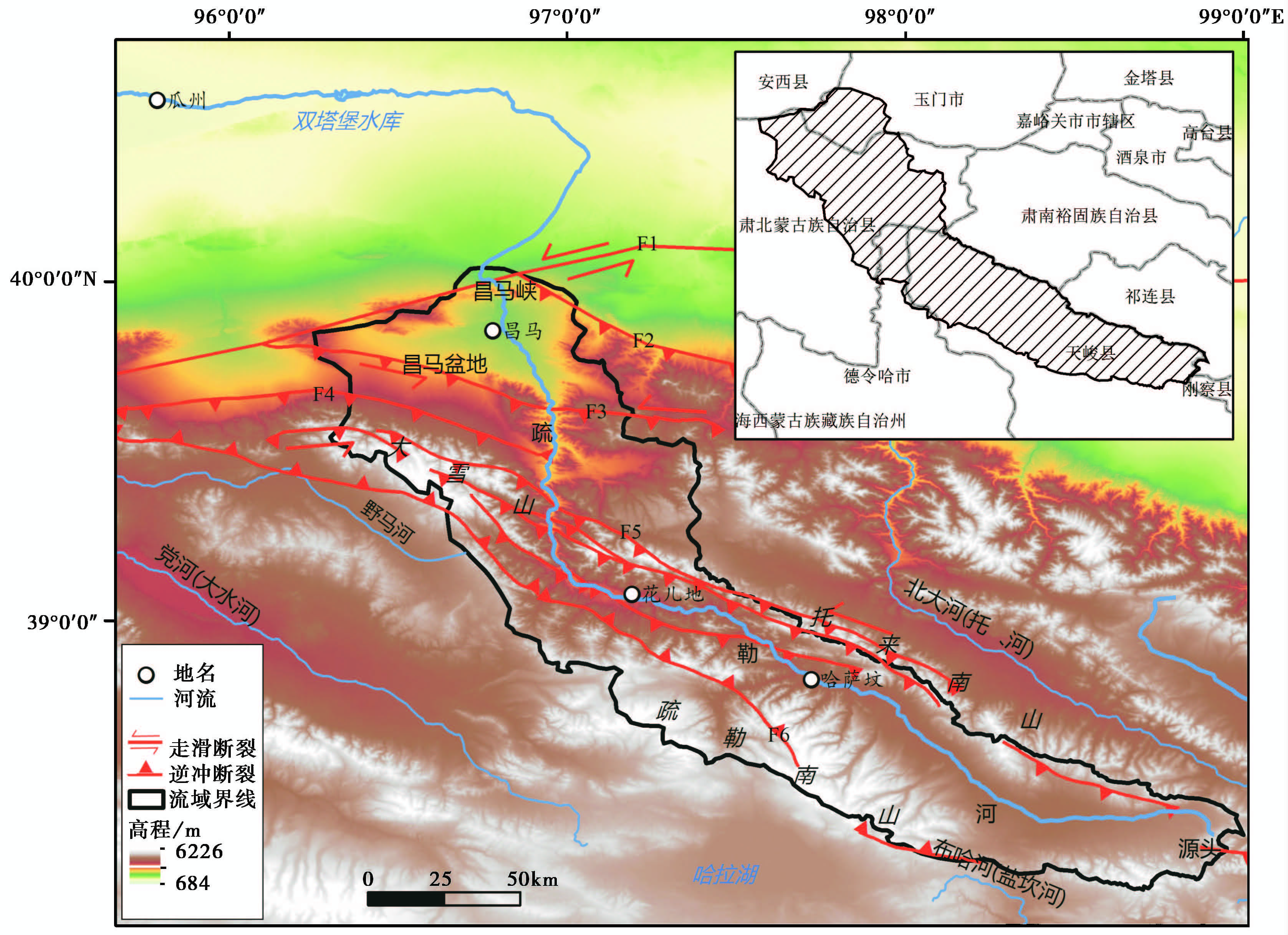
2 研究区概况疏勒河是甘肃省内陆河三大水系之一,发源于 祁连山脉西段疏勒南山,自东向西流经青海、甘肃 和新疆三省区。由发源地至近期终端湖哈拉诺尔, 干流全长670km,以昌马峡、瓜州双塔堡水库为分 界划分为上游、中游和下游[14, 15, 16, 17]。作为本文研究 对象的上游区域,位于疏勒南山与托来南山之间, 为疏勒河出山口以上的区域,行政上地跨青海省海 西蒙古族自治州的天峻县和甘肃省酒泉市的肃北蒙 古族自治县[18],如图1所示。
|
图1
研究区位置及DEM图 F1——阿尔金断裂 F2——旱峡-大黄沟断裂 F3——昌马断裂 F4——大雪山北缘断裂 F5——托来南山断裂 F6——疏勒南山断裂 Fig.1 The location and DEM of research area |
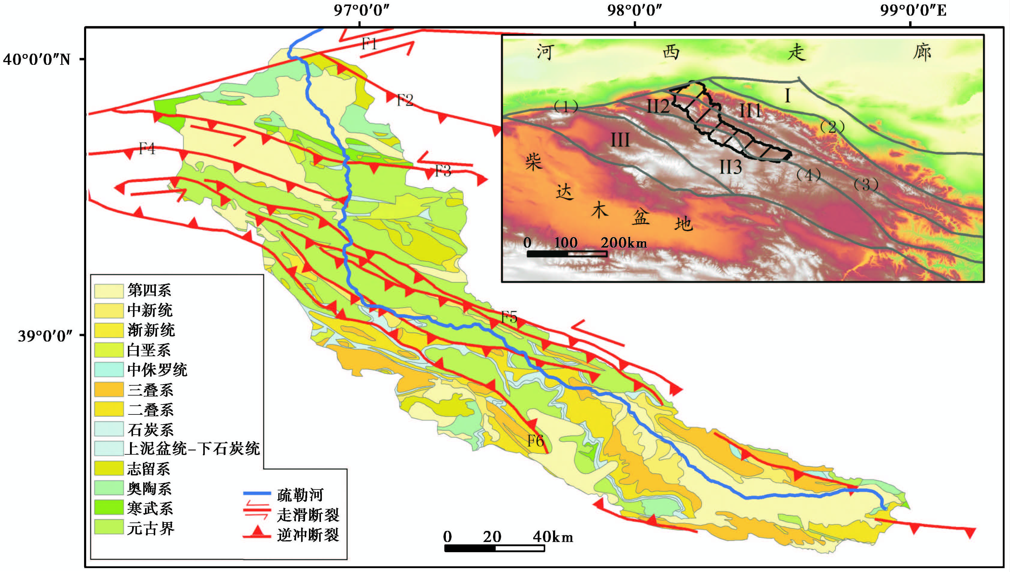
疏勒河在花儿地一带强烈下切托来南山,形成疏勒峡,转向北流,横切大雪山进入昌马盆地[19]。流域内山脉、 河谷走向均呈北西向,疏勒南山、 托来南山和疏勒河谷地组成主要地形格架,山区地势高峻,谷地地形相对低缓[20]。地形切割深,属高山深切割区。大地构造属于中祁连-湟源陆块,两侧被中祁连北缘断裂带与中祁连南缘断裂带所控制,断裂主体为走向北西西-近东西向逆冲兼走滑断裂。在青藏高原新生代构造变形区划中,属于秦祁昆走滑-挤压造山域中的中祁连构造带,主要变形特征及构造样式为挤压逆冲、 左行走滑和局部断陷[21],见 图2所示。
|
图2
研究区地质简图[21, 22, 23, 24, 25] (1)阿尔金断裂带; (2)北祁连北缘断裂带; (3)中祁连北缘断裂带; (4)中祁连南缘断裂带 Ⅰ——走廊过渡带; Ⅱ1——北祁连构造带; Ⅱ2——中祁连构造带; Ⅱ3——南祁连构造带; Ⅲ——柴北缘构造带 F1——阿尔金断裂; F2——旱峡-大黄沟断裂; F3——昌马断裂; F4——大雪山北缘断裂; F5——托来南山断裂; F6——疏勒南山断裂 Fig.2 Geological map of research area[21, 22, 23, 24, 25] |
源头疏勒河盆地、 昌马盆地及河流两侧分布有新生代地层,研究区中部及昌马盆地周边山地分布有元古代地层、 古生代地层[22, 23]。疏勒河盆地是在古生代优地槽褶皱基底上延断裂发育的裂堑式断陷盆地,西段出露地层以中新统为主,东段出露第四系,北部边缘有中侏罗统分布,组成一个南部地势较缓北部地势较陡的不对称向斜构造[26]。主要发育的断裂有阿尔金断裂、 旱峡-大黄沟断裂、 昌马断裂、 大雪山北缘断裂、 托来南山断裂及疏勒南山断裂。
研究区年均气温低、 降水量少。年均气温-3.5℃,年降水量100-600mm,年均蒸发量1203.5mm,属大陆性干旱荒漠气候[20]。
3 数据和方法 3.1 数据数字高程模型(DEM)为定量化的地貌分析提供了基础数据[27, 28, 29, 30, 31, 32]。本文采用的DEM,是美国航天局(NASA)和日本经济产业省(METI)2009年共同推出的最新星载热发射仪和反射辐射仪(Advanced Spaceborne Thermal Emission and Reflection Radiometer)的全球数字高程模型(Global Digital Elevation Model,简称ASTER GDEM),覆盖范围为北纬83°至南纬83°和 99 % 的地球陆地表面,空间分辨率为30m,与分辨率为90m的SRTM 3 数据精度相比,有了很大的改进,为小尺度地形特征提取提供了强有力的数据支撑,能够更好的反映地貌特征[33, 34, 35, 36, 37, 38, 39, 40]。ASTER GDEM目前共有2版,第一版V001于2009年公布,第二版V002于2011年10月公布。本文采用的是第二版数据。
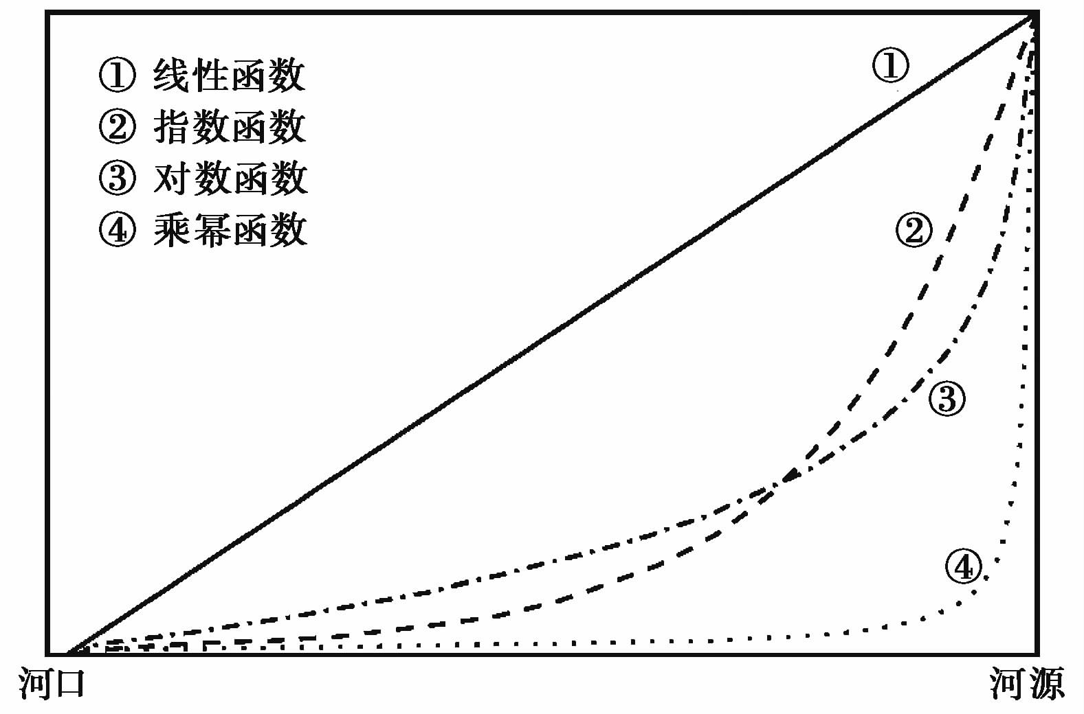
3.2 方法本文应用ArcGIS水文分析功能,提取了疏勒河上游河网及流域、 支流汇水盆地。根据提取的疏勒河干流,绘制了河流纵剖面并计算SL参数。 河流纵剖面反映了河流坡降从源头到下游的变化情况,其形态是流域中各种内在因素(河道基岩类型、 岩性、 构造和气候等)综合作用的结果,可用线性、 指数、 对数和乘幂等函数进行拟合[41, 42, 43, 44, 45, 46],如 图3,代表了地形受构造运动抬升后,河流纵剖面的不同演化阶段:1)初始河流纵剖面近乎一条直线,是线性剖面; 2)侵蚀作用使得纵剖面下凹程度增大,形成指数剖面; 3)侵蚀和堆积作用减少了河床高低差异,纵剖面演化成一条光滑下凹的对数剖面; 4)外界条件的变化增大河流净侵蚀力,加剧河流纵剖面下凹程度,演化为乘幂剖面。
|
图3 剖面的4种函数拟合形态比较[47] Fig.3 Fit to the river profile by four mathematic models |
Hack[46]在1973年提出了Hack剖面和河长坡降指标,即SL参数。Hack剖面是一种简化的河流纵剖面,以高度作为纵轴,距河源的距离取对数作为横轴,河流纵剖面即简化为一个对数方程: H=c-k×logL,其中: H为河流纵剖面的高度,c为常数,k为斜率,L为河段中点到源头的距离。斜率k即是SL参数。SL参数是河长坡降指标(stream length-gradient index,简称SL参数),可以近似用SL=(ΔH/ΔL)×L来表示,其中ΔH为局部河段的高程差,ΔL是局部河段的长度,L表示河段中心到源头的距离[46]。
Hack剖面反映了河流纵剖面的整体变化,可以有效指示较大时空尺度的构造运动[47]: 位于高抬升速率地区的河流Hack剖面呈凸形,中、 低抬升速率地区呈直线形、 凹形。而SL参数用局部河段坡度乘以河段中心距河源距离,放大局部坡度的数值效应,是反映岩石抗侵蚀能力和构造活动的重要参数[1, 45, 48]。
河流纵剖面拟合函数反映了河流发育阶段,Hack剖面和SL参数指示了构造运动[47, 48]。在构造抬升区,河流发育阶段是复杂的,河长坡降指标与Hack剖面等一维描述的地形指标容易受到局部构造的影响[47]。因此本文在上述地形指标的基础上,以三维描述的面积-高程积分(HI)来综合探讨河流地貌发育阶段。 面积-高程积分(HI)是Strahler[49]在1952年提出的,代表集水盆地在侵蚀作用下残留的物质比例。其简易计算公式为: HI=(Hmean-Hmin)/(Hmax-Hmin)[50],Hmean、 Hmin和Hmax分别代表流域内平均高程、 最小高程和最大高程。
流域边界线是整个流域的最高边缘线,跨越了流域内各个地貌类型单元,是一条稳定且能有效反映流域基本地形特征的特殊地形线[51, 52]。从边界曲线上获取所在空间位置的高程值绘制曲线即为流域边界剖面,蕴含了丰富的地貌特征等地学信息。
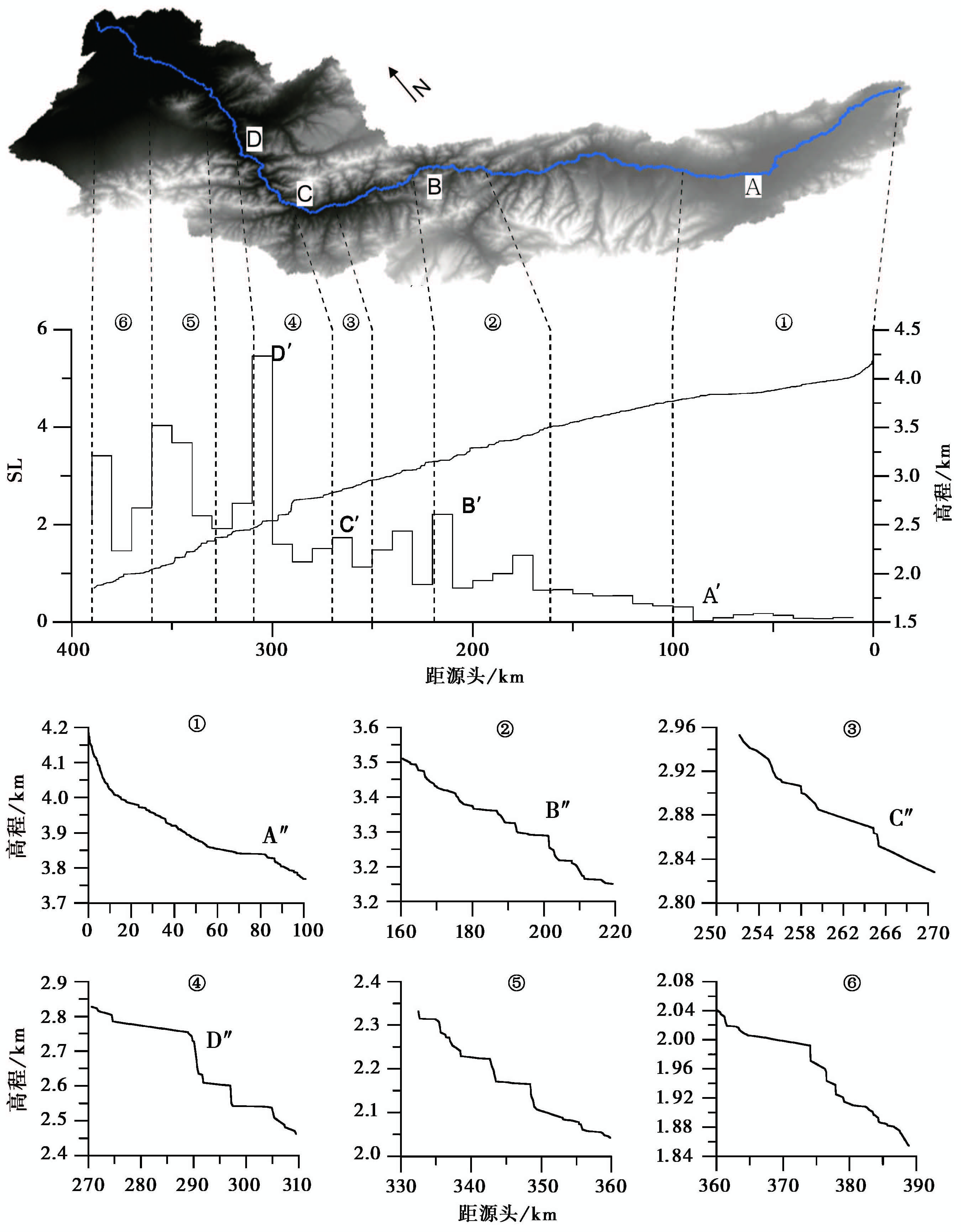
4 结果与讨论 4.1 河流纵剖面及河长坡降指标SL图4所示,研究区河长坡降指标SL呈现每百公里分段的特征,每段内皆存在异常高值或异常低值。河流流经的地层大多为元古代地层,以变质岩为主[22],岩性变化不大,故而异常值主要反映的是构造活动。
|
图4 疏勒河上游河流纵剖面、 SL及局部河段纵剖面 Fig.4 River profile,SL index and six segments' profiles of the upper Shule River |
图4中①、 ②、 ③、 ④、 ⑤和⑥分别是SL异常值附近的河流纵剖面,在 图4中与SL及河流做了对应。可以看出,SL异常值对应着河流裂点,裂点指示了构造抬升或河流袭夺事件[3, 53, 54]。河流纵剖面在200km、 265km、 290km、 340-350km和375km附近存在裂点。290km附近裂点位于托来南山断裂; 340-350km裂点位于昌马断裂处; 375km附近裂点位于出山口阿尔金断裂。
图4中的A、 B和C是河流流向发生转折处,对应的A′、 B′和C′是SL异常处,A″、 B″和C″是河流纵剖面明显陡变处,即流向转折与SL异常、 河流纵剖面变化具有良好的对应关系。A处河流流向由近西向转向北西向,SL出现一个低值(A′点处),对应着河段①的A″裂点; B处河流流向由北西向转向北西西向,SL出现一个高值(B′点处),对应着河段②的B″ 裂点,裂点附近存在一条逆冲断裂(见 图1和 图2); C处河流流向由北西西向转向近北向,SL出现一个高值(C′点处),对应着河段③的C″ 裂点; D处河流流向没有发生明显变化,但由于托来南山断裂的影响,SL却出现一个异常高值 (D′点处),河流纵剖面出现大落差的裂点D″(河段④)。
针对河段纵剖面的函数拟合结果如 表1所示。其中判定系数值(coefficient of determination,简称R2)是判断数学函数是否为最佳拟合函数的重要依据[41]。R2结果表明,疏勒河上游剖面以线性函数为最佳拟合函数,其次为指数函数,说明疏勒河处于河流发育早期阶段。而对局部河段纵剖面的拟合结果显示,判定系数R2数值接近,且均大于0.9,说明纵剖面呈现类似复合函数的形态,这是由于某段河流纵剖面突然变得平滑或者下凹所致。
| 表1 纵剖面函数拟合结果 Table 1 The fit-function of the stream segment profile |
疏勒河的Hack剖面呈明显的凸形( 图5),表明第四纪以来流域所在地区处于强烈的构造抬升状态。在0-50km的河段,Hack剖面较平直,略上凸; 50-100km呈现轻微下凹; 在100km以后的河段,剖面曲线急剧下降。
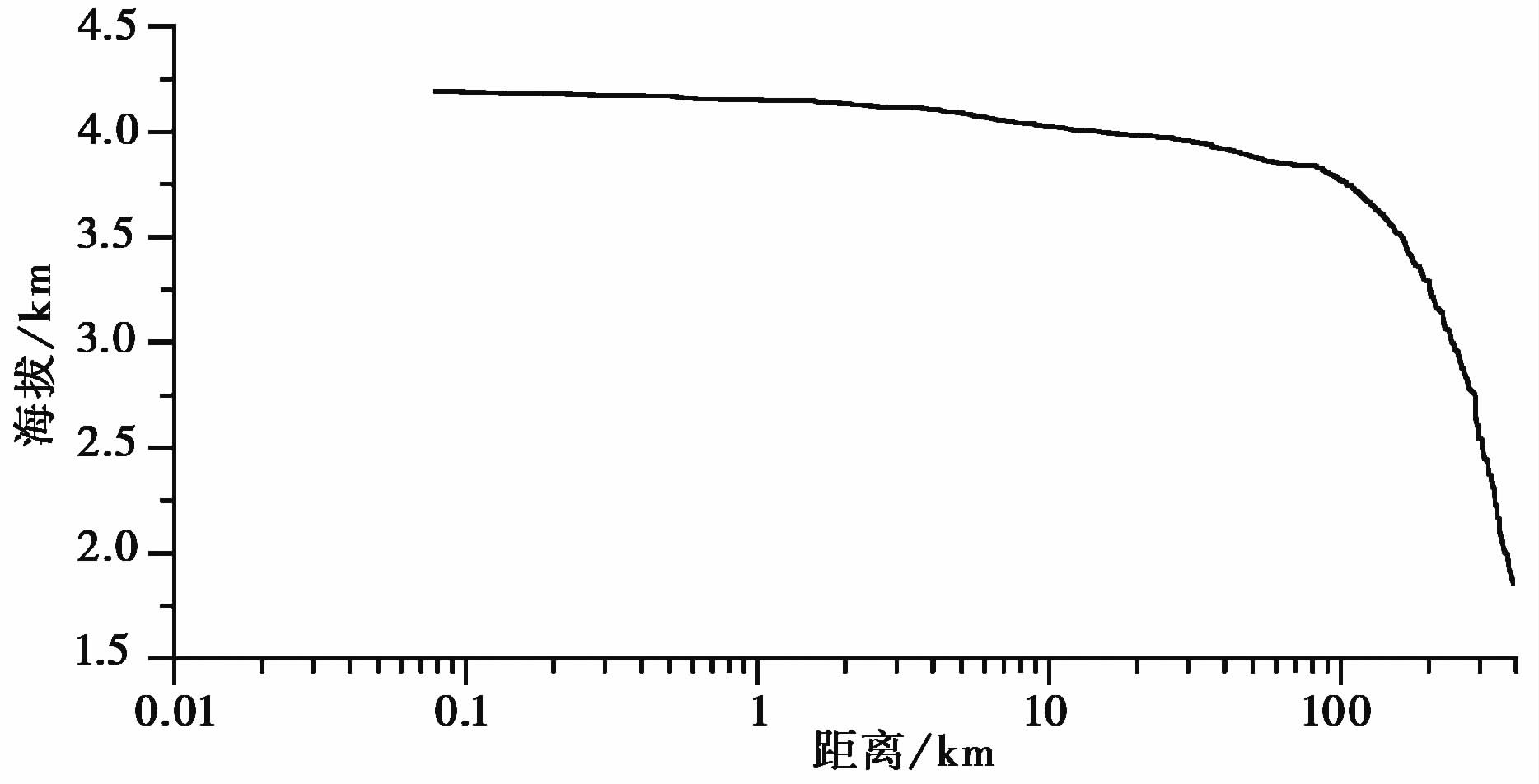
|
图5 疏勒河上游Hack剖面 Fig.5 Hack profile of the upper Shule River |
疏勒河上游流域的HI值是0.49,河源到80km处以上区域的HI值是0.23,说明与整个上游流域处于不同的发育阶段。 图6选取了河流两侧20个次级流域,其HI值分布区间为0.292-0.547。位于源头的次级流域1的HI值为0.292,是最小值,说明次级流域1处于河流演化的老年期阶段; 次级流域16的HI值为0.547,是最大值,说明次级流域16处于河流演化的幼年期阶段; 次级流域19的HI值为0.535,同样处于河流演化的幼年期阶段。源头至出山口次级流域所处发育阶段从老年期到中年期直到幼年期。
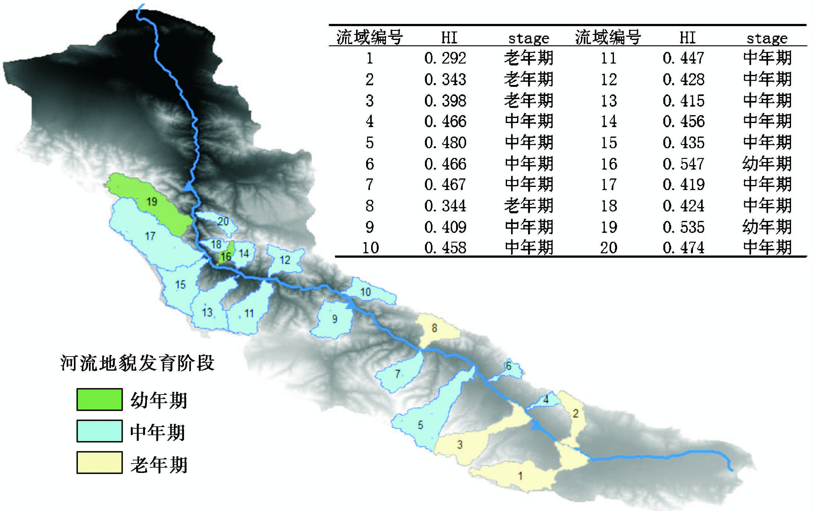
|
图6 疏勒河上游流域河流地貌发育阶段 Fig.6 Fluvial geomorphic development stage of the upper Shule River |
疏勒河上游流域边界高程剖面( 图7)刻画了流域之间的沟间地地形。剖面曲线存在5个明显的波谷,即a′、 b′、 c′、 d′和e′,对应着DEM的a、 b、 c、 d和e 等5个位置。a′(a)和 e′(e)是由于托来南山断裂造成的,b′、 c′和d′则是山脊上明显的下凹处,即垭口。
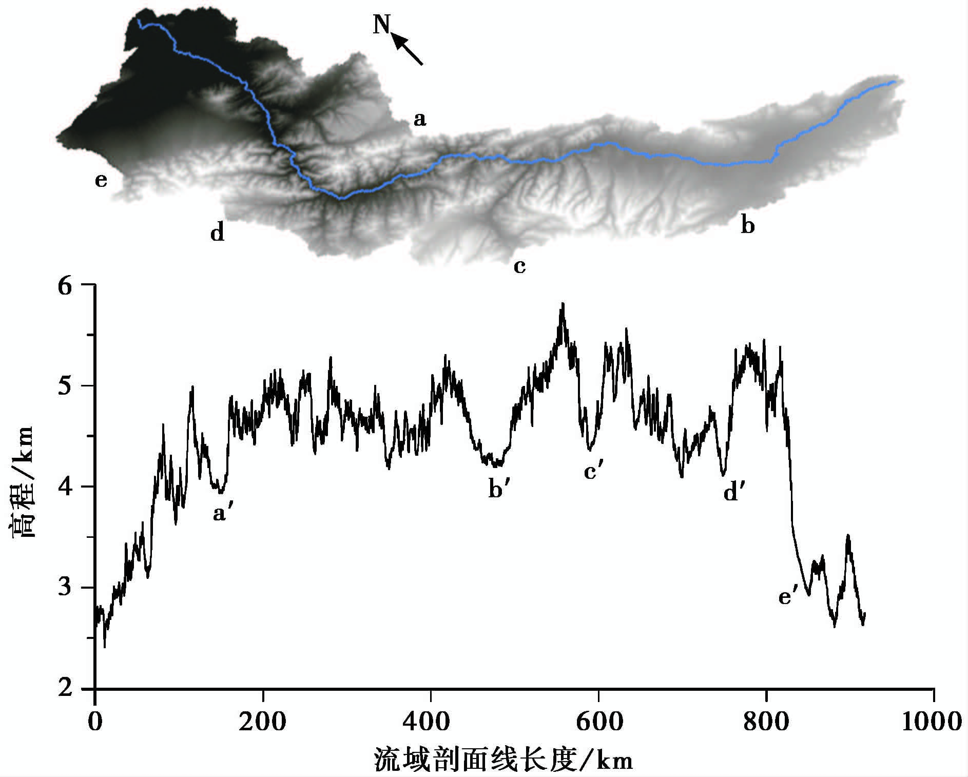
|
图7 疏勒河上游流域边界剖面 Fig.7 Watershed boundary elevation profile of the upper Shule River |
由于青藏高原在新生代的新构造活动,研究区处于强烈的构造抬升,从而使得河流的Hack剖面表现为明显的上凸。疏勒河上游从源头到出山口,河段处于不同的发育阶段,源头较老,接近出山口则较新( 图6),并且这种变化趋势与SL值、 河流纵剖面裂点( 图4)相对应: 不同发育阶段之间的过渡地带与河流拐弯、 SL异常以及裂点重合。 图7中b、 c和d垭口的位置又与上述特征点重合。河流流向转折、 裂点和垭口指示了河流因袭夺而发生的河流重组[55]。根据疏勒河上游河流拐弯、 SL异常、 裂点和垭口的分析结果,推测研究区发生过3次河流袭夺事件:1)古疏勒河南西向注入哈拉湖。由于疏勒南山断裂在第四纪的活动,哈拉湖所在地区相对于疏勒河源头地区下陷,而疏勒南山南段( 图7中b处位置)隆升,河流西流受阻,在疏勒河盆地聚集成湖,图7中b处垭口形成并保留原河道的宽谷( 图7中b′ 处位置),疏勒河盆地开始接受湖积和化学沉积[23]。这个时期,野马河的源头位于 图4中B处( 图8a和 图8b)。2)野马河溯源侵蚀,切开山脉,袭夺原属于湖泊的内流河,同时由于研究区抬升速率东部大于西部[5],在抬升过程中,湖水藉由野马河道向北西方向流动,由此,原有的湖泊被野马河袭夺。在袭夺点处,SL有一个相对异常高值( 图4),河流流向变化不明显( 图8c)。3)古昌马河溯源侵蚀,切开大雪山,袭夺古野马河,形成现在的疏勒河,留下 图7中d处垭口、 图4中C处SL异常及河流拐弯等地貌特征( 图8d)。
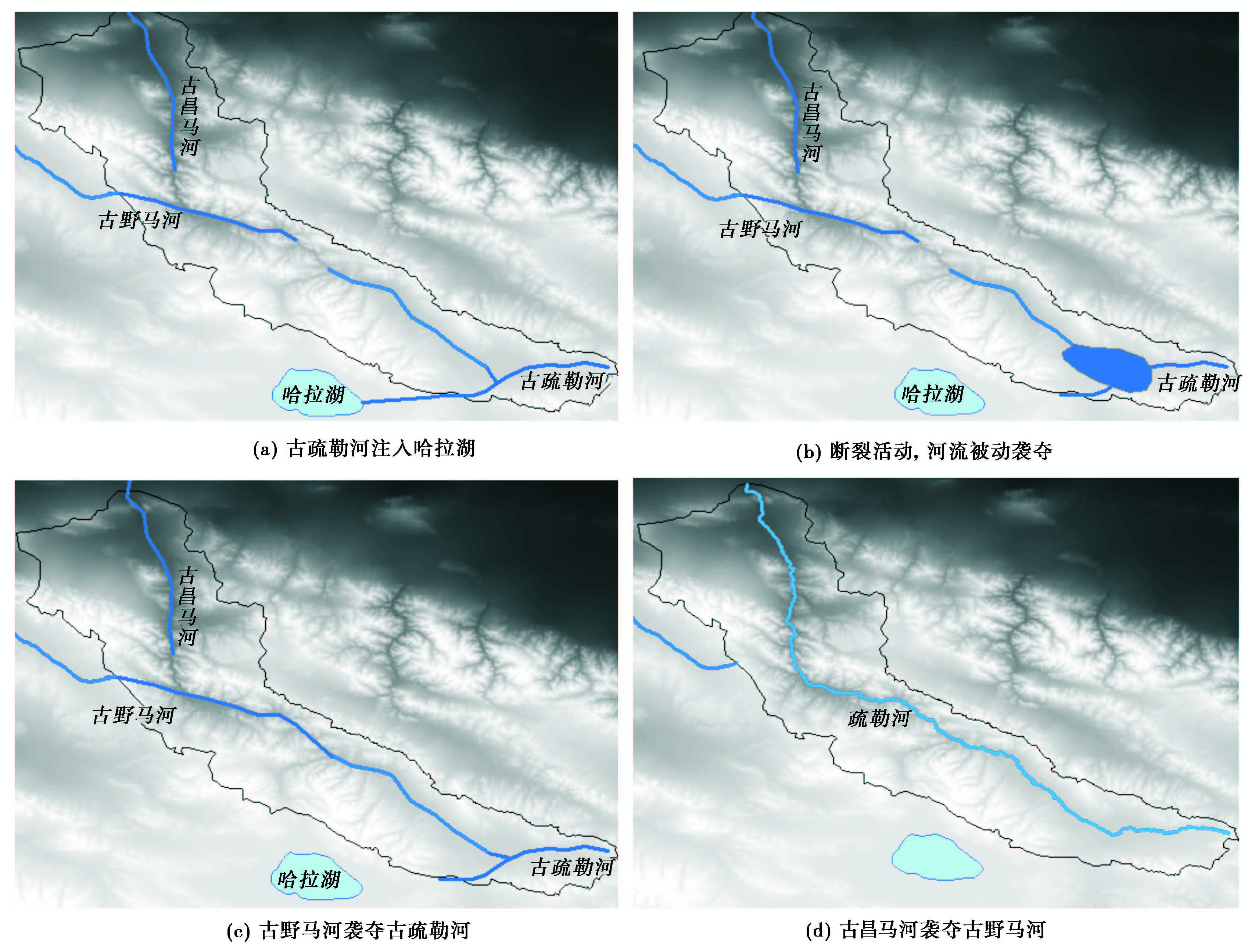
|
图8 疏勒河的演化 Fig.8 The evolution of Shule River |
疏勒河上游地区受到中祁连南缘断裂带、 中祁连北缘断裂带的差异控制,东部构造抬升幅度大于西部。在构造内力为主因的基础上,河流溯源侵蚀作为重要的外营力,在疏勒河上游河流演化与内力作用具有同样重要的地位。本文以疏勒河上游为研究对象,分析了河流纵剖面、 Hack剖面、 SL参数和HI,总结了河流的形态特征。与此同时,引入了流域边界高程剖面的方法,将研究对象从河道扩展到流域。分析结果显示,流域边界高程剖面真实反映了流域演化遗留的地貌证据。疏勒河上游河流纵剖面以线性函数为最佳拟合函数,说明疏勒河上游河段整体上处于河流发育早期阶段。Hack剖面呈明显的凸形,说明第四纪以来流域所在地区处于强烈的构造抬升。河流流向转折、 SL异常值、 河流纵剖面裂点具有良好的一致性,从流域边界剖面识别的垭口又与上述三者具有对应关系。综合上述河流特征及流域边界剖面所反映的地貌信息,推测研究区发生过3次袭夺事件,古疏勒河、 古昌马河以及古野马河的重组塑造了现在的疏勒河流域。
| 1 | 朱利东. 青藏高原北部隆升与盆地和地貌记录. 成都: 成都理工大学博士论文, 2004. 1-218Zhu Lidong. Uplift of the North of Qinghai-Tibet Plateau and Record in Basins and Geomorphy. Chengdu:The Thesis of Doctor's Degree of Chengdu University of Technology, 2004. 1-218 |
| 2 | 周民都, 吕太乙, 张元生等. 青藏高原东北缘地质构造背景及地壳结构研究. 地震学报, 2000, 22 (6):645~653 Zhou Mindu, Lü Taiyi, Zhang Yuansheng et al. The geological structure background and the crustal structure in the northeastern margin of the Qinghai-Tibetan Plateau. Acta Seismologica Sinica, 2000, 22 (6):645~653 |
| 3 | Brookfield M E. The evolution of the great river systems of Southern Asia during the Cenozoic India-Asia collision. Geomorphology, 1998, 22:285~312 |
| 4 | 陈建军, 季建清, 龚俊峰等. 雅鲁藏布江大峡谷的形成. 地质通报, 2008, 27 (4):491~499 Chen Jianjun, Ji Jianqing, Gong Junfeng et al. Formation of the Yarlung Zangbo grand canyon, Tibet, China. Geological Bulletin of China, 2008, 27 (4):491~499 |
| 5 | 胡小飞, 潘保田, Kirby E等. 河道陡峭指数所反映的祁连山北翼抬升速率的东西差异. 科学通报, 2010, 55 (23):2329~2338 Hu Xiaofei, Pan Baotian, Kirby E et al. Spatial differences in rock uplift rates inferred from channel steepness indices along the northern flank of the Qilian Mountain, northeast Tibetan Plateau. Chinese Science Bulletin, 2010, 55 (23):2329~2338 |
| 6 | 李 勇, Densmore A L, 周荣军等. 青藏高原东缘数字高程剖面及其对晚新生代河流下切深度和下切速率的约束. 第四纪研究, 2006, 26 (2):236~243 Li Yong, Densmore A L, Zhou Rongjun et al. Profiles of Digital Elevation Models(DEM)crossing the eastern margin of the Tibetan Plateau and their constraints on dissection depths and incision rates of Late Cenozoic rivers. Quaternary Sciences, 2006, 26 (2):236~243 |
| 7 | 张会平, 杨 农, 张岳桥等. 岷江水系流域地貌特征及其构造指示意义. 第四纪研究, 2006, 26 (1):126~135 Zhang Huiping, Yang Nong, Zhang Yueqiao et al. Geomorphology of the Minjiang drainage system(Sichuan, China)and its structural implications. Quaternary Sciences, 2006, 26 (1):126~135 |
| 8 | 张会平, 张培震, 吴庆龙等. 循化-贵德地区黄河水系河流纵剖面形态特征及其构造意义. 第四纪研究, 2008, 28 (2):299~309 Zhang Huiping, Zhang Peizhen, Wu Qinglong et al. Characteristics of the Huanghe River longitudinal profiles around Xunhua-Guide area(NE Tibet)and their tectonic significance. Quaternary Sciences, 2008, 28 (2):299~309 |
| 9 | 张会平, 张培震, 郑德文等. 祁连山构造地貌特征: 青藏高原东北缘晚新生代构造变形和地貌演化过程的启示. 第四纪研究, 2012, 32 (5):907~920 Zhang Huiping, Zhang Peizhen, Zheng Dewen et al. Tectonic geomorphology of the Qilian Shan: Insights into the Late Cenozoic landscape evolution and deformation in the north eastern Tibetan Plateau. Quaternary Sciences, 2012, 32 (5):907~920 |
| 10 | 王一舟, 张会平, 俞晶星等. 祁连山洪水坝河流域地貌特征及其构造指示意义. 第四纪研究, 2013, 33 (4):737~745 Wang Yizhou, Zhang Huiping, Yu Jingxing et al. Geomorphic features of the Hongshuiba River drainage basin in Qilianshan Mountain and its insight into tectonic implications. Quaternary Sciences, 2013, 33 (4):737~745 |
| 11 | 张沛全, 孙 杰, 刘小汉等. 南盘江-红水河(中段)的河流地貌特征与地壳变形. 第四纪研究, 2013, 33 (4):771~784 Zhang Peiquan, Sun Jie, Liu Xiaohan et al. Features of fluvial landform and crust deformations along the Nanpanjiang River-Hongshuihe River(middle segment). Quaternary Sciences, 2013, 33 (4):771~784 |
| 12 | 陈建军, 季建清, 余绍立. 雅鲁藏布江大峡谷地貌响应时间域的定量计算. 第四纪研究, 2008, 28 (2):264~272 Chen Jianjun, Ji Jianqing, Yu Shaoli. Quantitative Analysis of Geomorphologic Response Time-scale of the Yarlung Zangbo Great Canyon. Quaternary Sciences, 2008, 28 (2):264~272 |
| 13 | 王 平, 刘少峰, 郑洪波等. 四川盆地东部弧形构造控制的地形和水系发育. 第四纪研究, 2013, 33 (3):461~470 Wang Ping, Liu Shaofeng, Zheng Hongbo et al. Structural control on topography and drainage development in arcuate fold-thrust belts in eastern Sichuan Basin. Quaternary Sciences, 2013, 33 (3):461~470 |
| 14 | 韩金强. 甘肃内陆河流域水问题及对策研究. 中国水利, 2002,(2):58~59 Han Jinqiang. Study on water problems and countermeasures in inland river basin in Gansu Province. China Water Resource, 2002,(2):58~59 |
| 15 | 王 萍, 卢演俦, 丁国瑜等. 甘肃疏勒河冲积扇发育特征及其对构造活动的响应. 第四纪研究, 2004, 24 (1):74~81 Wang Ping, Lu Yanchou, Ding Guoyu et al. Response of the development of the Shule River alluvial fan to tectonic activity. Quaternary Sciences, 2004, 24 (1):74~81 |
| 16 | 蓝永超, 胡兴林, 丁宏伟等. 气候变暖背景下祁连山西部山区水循环要素的变化——以疏勒河干流上游山区为例. 山地学报, 2012, 30 (6):675~680 Lan Yongchao, Hu Xinglin, Ding Hongwei et al. Variation of water cycle factors in the western Qilian Mountain area under climate warming——Taking the mountain watershed of the main stream of Shule River basin for example. Journal of Mountain Science, 2012, 30 (6):675~680 |
| 17 | 周长进, 张义丰, 董锁成等. 疏勒河流域天然水质研究及水环境保护. 自然资源学报, 2004, 19 (5):604~609 Zhou Changjin, Zhang Yifeng, Dong Suocheng et al. Water quality and water environmental protection of the Shule River basin. Journal of Natural Resources, 2004, 19 (5):604~609 |
| 18 | 盛 煜, 李 静, 吴吉春等. 基于GIS的疏勒河流域上游多年冻土分布特征. 中国矿业大学学报, 2010, 29 (1):32~39 Sheng Yu, Li Jing, Wu Jichun et al. Distribution patterns of permafrost in the upper area of Shule River with the application of GIS technique. Journal of China University of Mining & Technology, 2010, 29 (1):32~39 |
| 19 | 尹泽生, 徐叔鹰. 祁连山区域地貌与制图研究. 北京: 科学出版社, 1992. 1-246Yin Zesheng, Xu Shuying. Study on the Landform and Mapping of Qilian Mountain. Beijing:Science Press, 1992. 1-246 |
| 20 | 谢 霞, 杨国靖, 王增如等. 疏勒河上游山区不同海拔梯度的景观格局变化. 生态学杂志, 2010, 29 (7):1420~1426 Xie Xia, Yang Guojing, Wang Zengru et al. Landscape pattern change in mountainous areas along an altitude gradient in the upper reaches of Shule River. Chinese Journal of Ecology, 2010, 29 (7):1420~1426 |
| 21 | 潘桂棠, 王立全, 张万平等. 青藏高原及邻区大地构造图及说明书(1 ︰ 1500000). 北京: 地质出版社, 2013Pan Guitang, Wang Liquan, Zhang Wanping et al. Tectonic Map and Directions of the Qinghai-Tibetan Plateau and Adjacent Areas(1 ︰ 1500000). Beijing:Geological Publishing House, 2013 |
| 22 | 国家地震局地质研究所, 国家地震局兰州地震研究所. 祁连山—河西走廊活动断裂系. 北京: 地震出版社, 1993. 1-135Institute of Geology, State Seismological Bureau, Earthquake Research Institute of Lanzhou. Qilian Mountains and Hexi Corridor Active Fault System. Beijing:Seismological Press, 1993. 1-135 |
| 23 | 马丽芳主编. 中国地质图集. 北京: 地质出版社, 2002Ma Lifang ed. Chinese Geological Atlas. Beijing:Geological Publishing House, 2002 |
| 24 | 罗 浩, 何文贵, 王定伟等. 祁连山昌马断裂晚更新世滑动速率. 地震地质, 2013, 35 (4):765~777 Luo Hao, He Wengui, Wang Dingwei et al. Study on the slip rate of Changma fault in Qilian Mountains since Late Pleistocene. Seismology and Geology, 2013, 35 (4):765~777 |
| 25 | 黄瑞华. 祁连山地区大地构造演化及其性质特征. 大地构造与成矿学, 1996, 20 (2):95~104 Huang Ruihua. Geotectonic evolution and its characteristics of Qilian Mountains area. Geotectonica et Metallogenia, 1996, 20 (2):95~104 |
| 26 | 青海省地质矿产局. 青海省区域地质志. 北京: 地质出版社, 1991. 1-604Qinghai Bureau of Geology and Mineral Resources. Regional Geology of Qinghai Province. Beijing:Geological Publishing House, 1991. 1-604 |
| 27 | 施 炜. 黄河中游晋陕峡谷的DEM流域特征分析及其新构造意义. 第四纪研究, 2008, 28 (2):288~298 Shi Wei. DEM drainage analysis of the Shanxi-Shaanxi Gorge in the middle reaches of the Huanghe River and its geotectonic implications. Quaternary Sciences, 2008, 28 (2):288~298 |
| 28 | 毕丽思, 何宏林, 魏占玉等. 利用分形参数进行地貌定量分区研究——以鄂尔多斯块体及周边为例. 第四纪研究, 2011, 31 (1):137~149 Bi Lisi, He Honglin, Wei Zhanyu et al. Study on the geomorphologic zonation by fractal parameters——A case study of Ordos block and its surrounding areas. Quaternary Sciences, 2011, 31 (1):137~149 |
| 29 | 翟秀敏, 鹿化煜, 李郎平等. 不同时间尺度洛川塬地貌演化与侵蚀量估算. 第四纪研究, 2012, 32 (5):839~848 Zhai Xiumin, Lu Huayu, Li Langping et al. Landscape evolution and surface erosion of Luochuan Tableland(central Chinese Loess Plateau)at different time scales. Quaternary Sciences, 2012, 32 (5):839~848 |
| 30 | 李利波, 徐 刚, 胡健民等. 基于DEM渭河上游流域的活动构造量化分析. 第四纪研究, 2012, 32 (5):866~879 Li Libo, Xu Gang, Hu Jianmin et al. Quantitative analysis of relative active tectonics of the upstream region of Weihe River based on DEM. Quaternary Sciences, 2012, 32 (5):866~879 |
| 31 | 徐岳仁, 何宏林, 邓起东等. 山西霍山山脉河流地貌定量参数及其构造意义. 第四纪研究, 2013, 33 (4):746~759 Xu Yueren, He Honglin, Deng Qidong et al. Quantitative river geomorphic parameters surrounding Mts. Huoshan, Shanxi Province and their tectonic implications. Quaternary Sciences, 2013, 33 (4):746~759 |
| 32 | 钱 程, 崔天日, 江 斌等. 长白山地区晚新生代火山地貌形态研究及其地质应用. 第四纪研究, 2014, 34 (2):312~324 Qian cheng, Cui Tianri, Jiang Bin et al. A study on the characteristic of Late Cenozoic volcanic terrain in Changbaishan Mountain and its geological application. Quaternary Sciences, 2014, 34 (2):312~324 |
| 33 | 郭笑怡, 张洪岩, 张正祥等. ASTER-GDEM与SRTM3数据质量精度对比分析. 遥感技术与应用, 2011, 26 (3):334~339 Guo Xiaoyi, Zhang Hongyan, Zhang Zhengxiang et al. Comparative analysis of the quality and accuracy between ASTER-GDEM and SRTM 3. Remote Sensing Technology and Application, 2011, 26 (3):334~339 |
| 34 | 钱 程, 韩建恩, 朱大岗等. 基于ASTER-GDEM数据的黄河源地区构造地貌分析. 中国地质, 2012, 39 (5):1247~1260 Qian Cheng, Han Jian'en, Zhu Dagang et al. An analysis of geomorphologic characteristics of the Yellow River source region based on ASTER-GDEM. Geology in China, 2012, 39 (5):1247~1260 |
| 35 | 张朝忙, 刘庆生, 刘高焕等. SRTM 3与ASTER GDEM数据处理及应用进展. 地理与地理信息科学, 2012, 28 (5):29~34 Zhang Chaomang, Liu Qingsheng, Liu Gaohuan et al. Data processing and application progress of SRTM 3 and ASTER GDEM. Geography and Geo-Information Science, 2012, 28 (5):29~34 |
| 36 | 张学儒, 官冬杰, 牟凤云等. 基于ASTER GDEM数据的青藏高原东部山区地形起伏度分析. 地理与地理信息科学, 2012, 28 (3):11~14 Zhang Xueru, Guan Dongjie, Mu Fengyun et al. Analysis on the relief amplitude based on ASTER GDEM data in mountain of eastern Tibetan Plateau. Geography and Geo-Information Science, 2012, 28 (3):11~14 |
| 37 | 赵国松, 杜 耘, 凌 峰等. ASTER GDEM与SRTM3高程差异影响因素分析. 测绘科学, 2012, 37 (4):167~170 Zhao Guosong, Du Yun, Ling Feng et al. Analysis of influencing factors on height differences between ASTER GDEM and SRTM 3. Science of Surveying and Mapping, 2012, 37 (4):167~170 |
| 38 | 闫 鹏, 杨 农, 叶宝莹. 基于ASTER-GDEM 的贵州及其邻区地貌面提取及研究. 国土资源遥感, 2011,(2):98~103 Yan Peng, Yang Nong, Ye Baoying. The extraction and study of geomorphic surface in Guizhou and its adjacent areas based on ASTER-GDEM. Remote Sensing for Land & Resources, 2011,(2):98~103 |
| 39 | 曹小敏, 罗明良, 刘承栩. 基于ASTER-GDEM的延河流域水系分维特征分析. 遥感信息, 2013, 28 (1):34~37 Cao Xiaomin, Luo Mingliang, Liu Chengxu. Fractal dimension of Yanhe River based on ASTER-GDEM. Remote Sensing Information, 2013, 28 (1):34~37 |
| 40 | 赵国华, 李 勇, 闫照坤等. 龙门山中段山前河流Hack剖面和面积-高程积分的构造地貌研究. 第四纪研究, 2014, 34 (2):302~310 Zhao Guohua, Li Yong, Yan Zhaokun et al. Tectonic geomorphology analysis of piedmont rivers of the middle Mt. Longmenshan basin on Hack profile and hypsometric integral. Quaternary Sciences, 2014, 34 (2):302~310 |
| 41 | 赵洪壮, 李有利, 杨景春等. 天山北麓河流纵剖面与基岩侵蚀模型特征分析. 地理学报, 2009, 64 (5):563~570 Zhao Hongzhuang, Li Youli, Yang Jingchun et al. The longitudinal profiles of the ten rivers in north Tianshan Mountains and their tectonic significance. Acta Geographica Sinica, 2009, 64 (5):563~570 |
| 42 | Shepherd R G. Regression analysis of river profile. Journal of Geology, 1973, 93 (3):377~384 |
| 43 | Ohmori H. Change in the mathematical function type describing the longitudinal profile of a river through an evolutionary process. Journal of Geology, 1991, 99 (1):97~110 |
| 44 | Snow R S, Slingerland R L. Mathematical modeling of graded river profile. Journal of Geology, 1987, 95 (1):15~33 |
| 45 | Hack J T. Studies of longitudinal stream profile in Virginia and Maryland. Journal of Research of the US Geological Survey, 1957, 294 (B):45~95 |
| 46 | Hack J T. Stream-profile analysis and stream-gradient index. Journal of Research of the U.S. Geological Survey, 1973, 1 (4):421~429 |
| 47 | 陈彦桀. 台湾山脉的构造地形指标特性——以面积高度积分、 地形碎形参数与河流坡降指标为依据. 台南: 成功大学博士论文, 2004. 1-129Chen Yanjie. Morphotectonic Features of Taiwan Mountain Belt Based on Hypsometric Integral, Topographic Fractals and SL Index. Tainan:The Thesis of Doctor's Degree of Cheng Kung University, 2004. 1-129 |
| 48 | 常直杨, 王 建, 白世彪等. 基于DEM的白龙江流域构造活动定量分析. 第四纪研究, 2014, 34 (2):292~300 Chang Zhiyang, Wang Jian, Bai Shibiao et al. Appraisal of active tectonic in Bailongjiang basin based on DEM data. Quaternary Sciences, 2014, 34 (2):292~300 |
| 49 | Strahler A N. Hypsometric(area-altitude)analysis of erosional topography. Geological Society of America Bulletin, 1952, 63 (11):1117~1141 |
| 50 | Pike R J, Wilson S E. Elevation-relief ratio, hypsometric integral, and geomorphic area altitude analysis. Geological Society of America Bulletin, 1971, 82 (4):1079~1084 |
| 51 | 曲木威振. 基于DEM的流域边界谱及空间分异研究——以在黄土地貌的实验为例. 西安: 西北大学硕士论文, 2008. 1-88Qumu Weizhen. Research on Watershed Boundary Spectrums and Their Spatial Variance Based on DEMs——Taking Loessial Landform as A Case Study. Xi'an:The Thesis of Masters degree of Northwestern University, 2008. 1-88 |
| 52 | 贾旖旎. 基于DEM的黄土高原流域边界剖面谱研究. 南京: 南京师范大学博士学位论文, 2010. 1-145Jia Yini. Study on Watershed Boundary Profile Spectral of Loess Plateau Based on DEM. Nanjing:The Thesis of Doctor's Degress of Nanjing Normal University, 2010. 1-145 |
| 53 | 张会平, 张培震, 樊祺诚. 河流裂点的发育及其溯源迁移: 以鸭绿江-望天鹅火山区为例. 中国科学: 地球科学, 2011, 41 (11):1627~1635 Zhang Huiping, Zhang Peizhen, Fan Qichen. Initiation and recession of the fluvial knickpoints:A case study from the Yalu River-Wangtian'e volcanic region, Northeastern China. Science China:Earth Science, 2011, 41 (11):1627~1635 |
| 54 | 王文鹄. 河流袭夺的几种形式. 地理学与国土研究, 1998, 14 (4):45~48 Wang Wenhu. The several forms of river capture. Geography and Land Research, 1998, 14 (4):45~48 |
| 55 | Ribolini A, Spagnolo M. Drainage network geometry versus tectonics in the Argentera Massif(French-Italian Alps). Geomorphology, 2008, 93 (3-4):253~266 |
Abstract
Shule River originates from the western part of the Qilianshan Mountain, between Shulenanshan Mountain and Tuolainanshan Mountain. The upper Shule River is located in the Middle Qilian block, differentially controlled by the Northern Middle Qilian Fault Zone and the Southern Middle Qilian Fault Zone. Its landform is the result of the uplift of the Qinghai-Tibetan Plateau. Altyn Tagh Fault, Hanxia-Dahuanggou Fault, Changma Fault, Northern Daxueshan Fault, Tuolainanshan Fault and Shulenanshan Fault are mainly active faults. In the study area, Cenozoic strata spreads in Shule River basin, Changma basin and both sides of the river. Proterozoic strata and Paleozoic strata spread in the middle part of the upper Shule River and mountains surrounding Changma basin.
In this study, the ASTER GDEM V002, spatial resolution of 30m, was utilized as basic data, and the hydrology tools were applied in ArcGIS to extract the river profile, Hack profile, SL index, and HI from the upstream basin of the Shule River to analyze fluvial geomorphology, and extract watershed boundary elevation profile to analyze geomorphic evidence left from the basin evolution.
There are three obvious fluvial elbows. In each bend of the river, there was a knickpoint and abnormally SL value. SL presents per 100km sectional characteristics. There are abnormal high values or abnormal low value in each section. The river segments with abnormally high SL values, mainly represented faults activity of study area. The obviously highest SL values appear in Tuolainanshan Fault. The linear function was the best fit-function for the river longitudinal profile of the upper Shule River, which indicated that the evolution process of the upper river was in an early stage. The morphology of Hack profiles was convex, which showed that the main factor causing the landform was tectonic uplifting in the upper Shule River. The HI of the Shule River upstream watershed was 0.49. From its river source to 80km afar, the HI was 0.23, which indicated that the stages of river development were different. The distribution interval of the both river sides' HI was 0.292 to 0.547. The HI showed that secondary basins of the river varying in developmental stages from old stage to middle stage to juvenile stage corresponding to the position from source to alluvial fan. The elevation of basin boundary indicated pass gaps position. Fluvial elbows, SL and knickpoints in the river were found close to one another and also near the pass gaps what were distinguished from watershed boundary elevation profile. These geomorphic information allows us to infer that the fluvial reorganization occurred by means of three fluvial captures. The recombinant of ancient Shule River, Changma River and Yema River shaped the current Shule River basin.
 2015, Vol.35
