2. 空间信息应用与防灾减灾技术交通运输行业研发中心, 北京市紫竹院路116号, 100097;
3. 中咨数据有限公司, 北京市紫竹院路116号, 100097;
4. 中国自然资源航空物探遥感中心环境遥感室, 北京市学院路31号, 100083
2018-10-11凌晨西藏昌都市江达县白格村附近发生山体滑坡,阻断金沙江干流形成堰塞湖。11-03滑坡点发生二次滑坡,再次造成金沙江断流[1]。滑坡灾害严重危害人民生命财产和工程设施安全,对潜在滑坡进行早期识别和稳定性持续监测对滑坡灾害预警至关重要。
合成孔径雷达(SAR,synthetic aperture radar)是一种主动式微波传感器,可以全天时、全天候获取SAR影像。SAR影像包含卫星与地物之间距离的相位信息和地物反射特性的强度信息,应用SAR影像相位信息的合成孔径雷达差分干涉测量技术(D-InSAR,differential SAR interferometry)以及基于D-InSAR技术发展起来的永久散射体干涉测量技术(PS-InSAR,permanent scatters InSAR)、小基线集技术(SBAS-InSAR,small baseline subsets InSAR)等可获取目标cm甚至mm级的形变情况[2-4],应用SAR影像强度信息的offset tracking等技术可以获取SAR影像1/10~1/20个像元精度的地物形变情况[5-6]。相比倾斜仪、位移计等现场仪器观测以及全球定位系统GPS、时域反射技术(TDR,time-domain reflectometry)等电子远程观测手段,基于星载SAR影像的滑坡监测手段除了可全天时、全天候、无需现场监测,还具有监测范围广、空间分辨率高等优势,已成为滑坡识别与位移测量的重要手段之一[7-9],其精度也经受住了国内外众多学者的验证[10-12]。本文首先基于高分二号和高分三号卫星数据,分析白格滑坡灾害发生所形成的堰塞湖对上游村镇的影响,然后基于Sentinel-1和ALOS-2 PALSAR-2数据,分别采用PS-InSAR和offset tracking技术获取白格滑坡的位移情况,并对其运动特征进行分析。
1 研究区概况白格滑坡位于四川甘孜州白玉县与西藏昌都市江达县交界处金沙江西侧,为岩质滑坡,坐标为31°04′55.8″N、98°42′14.69″E,具体位置如图 1所示。

|
图 1 研究区位置及本文使用的SAR数据覆盖范围 Fig. 1 The location of study area and coverage of the SAR data |
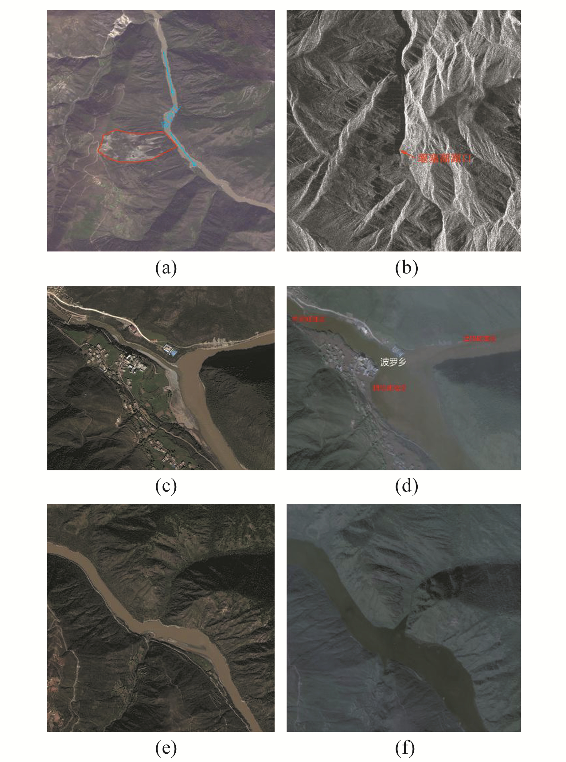
本文收集了灾害发生前后当地的高分二号和高分三号卫星影像,从遥感影像上分析滑坡对上游村镇造成的影响。其中,高分二号是我国高分辨率对地观测系统重大专项中分辨率最高的民用遥感卫星,最高空间分辨率可达0.8 m;高分三号是我国首颗C波段的高分辨率合成孔径雷达卫星,可为我国防灾减灾提供重要的遥感数据支撑。基于2017-10-18高分二号卫星0.8 m分辨率的SAR影像(图 2(a)),可以清楚看到滑坡的灰白色滑动面,表明在滑坡灾害发生前白格滑坡已经有明显的滑动迹象;基于2018-10-12高分三号卫星5 m分辨率的SAR影像(图 2(b)),可以清晰地看到金沙江已经被完全堵塞住,上游水位上升,下游水位下降甚至干涸。从滑坡发生前拍摄日期2017-10-18和滑坡发生后拍摄日期2018-10-12的高分二号卫星影像的对比图可以看到,由于金沙江堵塞的影响,波罗乡耕地、桥梁、道路以及房屋被上升的水位淹没(图 2(c)、2(d)),河面宽度明显上升,河边耕地和河中岛被淹没(图 2(e)、2(f))。

|
图 2 滑坡发生前后的遥感影像对比 Fig. 2 Remote sensing image contrast before and after landslide |
由于研究区地形起伏严重,降轨SAR影像上白格滑坡被叠掩或阴影覆盖,无法获取有效的相位和强度信息,故收集2017-05-17~2018-10-03期间40景TOPS模式的升轨Sentinel-1数据以及2015-07-27~2018-07-23期间4景地面分辨率6 m、stripmap模式的升轨ALOS-2 PALSAR-2数据用于监测白格滑坡滑移前的运动特征。
Sentinel-1和PALSAR-2数据的覆盖范围如图 1所示,其中Sentinel-1数据仅展示了覆盖白格滑坡的burst的覆盖范围,使用的2种SAR数据的具体参数如表 1所示,其中Sentinel-1(序号1~40)各期数据的空间垂直基线和时间基线均以2017-11-13获取的影像为参考影像计算得出,PALSAR-2(序号41~44)各期数据的基线信息均以2017-11-27获取的影像为参考影像计算得出。本文使用的DEM数据为TanDEM-X 90 m数据,由TanDEM-X 12 m高程数据采样而来,其高程精度优于10 m[13]。
|
|
表 1 本文使用的Sentinel-1和PALSAR-2数据的主要参数 Tab. 1 Parameters of Sentinel-1 and PALSAR-2 used in this paper |
PS-InSAR技术仅针对在时间上散射特性相对稳定、回波信号较强的PS进行相位建模与形变解算,从而分离出地表形变、大气延迟相位信息与高程残余相位信息[14]。PS在时间基线或空间基线很长的情况下,仍然保持很好的相干性和稳定性,通常包括人工基础设施和自然环境中的裸露岩石等地物。PS-InSAR技术主要包括3个步骤:1)对覆盖同一研究区的多幅SAR影像,选择合适的1幅作为主影像,其余影像分别与主影像配准,采用依据时间序列上的幅度和(或)相位信息的稳定性的振幅离差阈值法、相干系数法或相位分析法等方法选取PS目标;2)经过干涉和去除地形相位,得到永久散射体目标的差分干涉相位,并对相邻的永久散射体目标的差分干涉相位进行再次差分;3)根据2次差分后的干涉相位中各个相位成分的不同特性,采用构建形变相位模型和时空滤波的方式估计形变和地形残余信息。
offset tracking技术基于归一化互相关算法来获取影像在距离向和方位向的偏移量,该偏移量包含地物、地形、电离层及轨道相关的偏移量。其中地形和轨道相关的偏移量可应用外部DEM辅助的配准方法进行计算[15],电离层的影响在低纬度地区通常可以忽略[16],从而地物的偏移量可以计算出来。offset tracking技术的精度一般为SAR影像分辨率的1/10~1/20,以6 m分辨率的PALSAR-2影像为例,测量精度一般优于0.6 m。offset tracking技术在SAR影像之间相干性较低的情况下,仍可以直接得到目标地物距离向和方位向的偏移量,适用于形变量较大的冰川、滑坡等的运动监测。
3 结果与分析 3.1 基于PS-InSAR技术的滑坡形变分析基于获取的40景覆盖白格滑坡的升轨Sentinel-1数据,应用PS-InSAR技术进行处理,使用空间分辨率为90 m的TanDEM-X高程数据去除大部分的地形相关相位,获得白格滑坡周边的平均形变速率图(图 3)。

|
图 3 白格滑坡及周边区域平均形变图 Fig. 3 Average deformation of Baige landslide and surrounding area |
由图 3可见,研究区大部分区域的平均形变速率低于6 mm/a,表明监测区域总体稳定性较好。白格滑坡除滑坡体前缘处保留了少量形变信息,其余部位由于失相干的影响无法获得形变量的分布情况。根据PS-InSAR结果,白格滑坡前缘的形变速率存在超过2.5 cm/a的PS目标;监测范围内,存在2处活动性滑坡,分别位于白格滑坡西北方向约3 km处和正北方向约4 km处,其中,西北方向活动性滑坡监测点的最大年平均形变量超过3.5 cm,正北方向活动性滑坡监测点的最大年平均形变量超过4.5 cm。将2处活动性滑坡显示在谷歌地球上,如图 4所示,白色线条为疑似滑坡的可能边界。以上结果表明,基于PS-InSAR技术的监测结果可以有效识别出活动性滑坡。

|
图 4 基于PS-InSAR技术探测出的疑似滑坡的三维图 Fig. 4 3D map of the suspected landslide detected by the PS-InSAR technique |
由于白格滑坡滑动量过大,基于SAR影像相位信息的InSAR技术无法获得滑坡体主体的形变分布,故对收集到的时间分布在2015-07~2018-07的4景ALOS-2 PALSAR-2应用offset tracking技术,得到3个时间段的白格滑坡在雷达斜距向和方位向的形变分布,进而得到滑坡真实滑动量在斜距向和方位向平面投影的二维形变量分布图(图 5)。

|
图 5 基于谷歌地球显示的白格滑坡3个时间段的形变监测结果 Fig. 5 The monitoring results of the deformation of Baige landslide in three periods that displayed in Google Earth |
本文无滑坡形变实地测量数据,但理论上稳定地表区域的形变量应当为0,故将滑坡区域掩膜掉,统计其他区域形变量的均方根误差,来评价本文offset tracking滑坡形变测量的精度[17-18]。经统计,2015-07-27 ~ 2016-07-25、2016-07-25~2017-11-27及2017-11-27~ 2018-07-23这3个时间段内非滑坡区域形变量的均方根误差分别为0.64 m、0.72 m、0.66 m,约为使用的PALSAR-2数据的1/10像元左右,且远小于白格滑坡各个时间段的形变量,证明了本文offset tracking结果的可靠性。
根据offset tracking这3个时间段的形变结果可知(图 5),空间上3个时间段内白格滑坡的形变分布范围具有相似性,时间上3个时间段内白格滑坡的累计形变量最大依次可达6.6 m、17.8 m、23.2 m。为定量分析滑坡的速度变化情况,将滑坡每个时间段的最大累计形变量转为年平均滑动量(1 a按365 d计),年平均滑动速度分别为6.62 m/a、13.26 m/a、35.58 m/a,表明从2015-07~2018-07白格滑坡的平均滑动速度不断增加,呈明显加速现象。
4 结语本文基于滑坡事件发生前后的高分二号和高分三号卫星遥感数据分析白格滑坡灾害造成的影响,并利用收集的Sentinel-1和PALSAR-2数据,分别应用PS-InSAR和offset tracking技术对白格滑坡发生前的形变特征进行识别。根据PS-InSAR结果获得了白格滑坡前缘2017-05~2018-10的平均形变速率,在滑坡西南约3 km处及滑坡北面4 km处各发现1处疑似滑坡;基于offset tracking结果获得白格滑坡2015-07~2018-07间3个时间段的形变特征,发现白格滑坡在3个时间段滑动不断加速。基于PS-InSAR和offset tracking技术可以对活动性滑坡进行早期识别,并对活动性滑坡的形变特征进行定期观测,可以为滑坡灾害的预警提供重要参考。
致谢: 本文Sentinel-1卫星数据由ESA提供,ALOS-2卫星数据由PASCO和博宇智图共同提供,ALOS卫星数据版权归JAXA所有,在此一并表示感谢。
| [1] |
许强, 郑光, 李为乐, 等. 2018年10月和11月金沙江白格两次滑坡-堰塞堵江事件分析研究[J]. 工程地质学报, 2018, 26(6): 1 534-1 551 (Xu Qiang, Zheng Guang, Li Weile, et al. Study on Successive Landslide Damming Events of Jinsha River in Baige Village on Octorber 11 and November 3, 2018[J]. Journal of Engineering Geology, 2018, 26(6): 1 534-1 551)
(  0) 0) |
| [2] |
Ferretti A, Prati C, Rocca F. Nonlinear Subsidence Rate Estimation Using Permanent Scatterers in Differential SAR Interferometry[J]. IEEE Transactions on Geoscience and Remote Sensing, 2000, 38(5): 2 202-2 212 DOI:10.1109/36.868878
(  0) 0) |
| [3] |
Berardino P, Fornaro G, Lanari R, et al. A New Algorithm for Surface Deformation Monitoring Based on Small Baseline Differential SAR Interferograms[J]. IEEE Transactions on Geoscience and Remote Sensing, 2002, 40(11): 2 375-2 383 DOI:10.1109/TGRS.2002.803792
(  0) 0) |
| [4] |
Fan H D, Gao X X, Yang J K, et al. Monitoring Mining Subsidence Using a Combination of Phase-Stacking and Offset-Tracking Methods[J]. Remote Sensing, 2015, 7(7): 9 166-9 183 DOI:10.3390/rs70709166
(  0) 0) |
| [5] |
Strozzi T, Luckman A, Murray T, et al. Glacier Motion Estimation Using SAR Offset-Tracking Procedures[J]. IEEE Transactions on Geoscience and Remote Sensing, 2002, 40(11): 2 384-2 391 DOI:10.1109/TGRS.2002.805079
(  0) 0) |
| [6] |
Sun L Y, Muller J P. Evaluation of the Use of Sub-Pixel Offset Tracking Techniques to Monitor Landslides in Densely Vegetated Steeply Sloped Areas[J]. Remote Sensing, 2016, 8(8): 659 DOI:10.3390/rs8080659
(  0) 0) |
| [7] |
Colesanti C, Wasowski J. Investigating Landslides with Space-Borne Synthetic Aperture Radar (SAR) Interferometry[J]. Engineering Geology, 2006, 88(3-4): 173-199 DOI:10.1016/j.enggeo.2006.09.013
(  0) 0) |
| [8] |
Kiseleva E, Mikhailov V, Smolyaninova E, et al. PS-InSAR Monitoring of Landslide Activity in the Black Sea Coast of the Caucasus[J]. Procedia Technology, 2014, 16: 404-413 DOI:10.1016/j.protcy.2014.10.106
(  0) 0) |
| [9] |
Necula N, Niculiǎ M, Tessari G, et al. InSAR Analysis of Sentinel-1 Data for Monitoring Landslide Displacement of the North-Eastern Copou Hillslope, Iași City, Romania[C]. Romanian Geomorphology Symposium, Iași, 2017
(  0) 0) |
| [10] |
Ferretti A, Savio G, Barzaghi R, et al. Submillimeter Accuracy of InSAR Time Series: Experimental Validation[J]. IEEE Transactions on Geoscience and Remote Sensing, 2007, 45(5): 1 142-1 153 DOI:10.1109/TGRS.2007.894440
(  0) 0) |
| [11] |
汪宝存, 远顺立, 王继华, 等. InSAR地面沉降监测精度分析与评价[J]. 遥感信息, 2015, 30(4): 8-13 (Wang Baocun, Yuan Shunli, Wang Jihua, et al. Accuracy Analysis and Evaluation of InSAR Land Subsidence Monitoring[J]. Remote Sensing Information, 2015, 30(4): 8-13 DOI:10.3969/j.issn.1000-3177.2015.04.002)
(  0) 0) |
| [12] |
范景辉, 邱阔天, 夏耶, 等. 三峡库区范家坪滑坡地表形变InSAR监测与综合分析[J]. 地质通报, 2017, 36(9): 1 665-1 673 (Fan Jinghui, Qiu Kuotian, Xia Ye, et al. InSAR Monitoring and Synthetic Analysis of the Surface Deformation of Fanjiaping Landslide in the Three Gorges Reservoir Area[J]. Geological Bulletin of China, 2017, 36(9): 1 665-1 673)
(  0) 0) |
| [13] |
Wessel B, Huber M, Wohlfart C, et al. Accuracy Assessment of the Global TanDEM-X Digital Elevation Model with GPS Data[J]. ISPRS Journal of Photogrammetry and Remote Sensing, 2018, 139: 171-182 DOI:10.1016/j.isprsjprs.2018.02.017
(  0) 0) |
| [14] |
朱建军, 李志伟, 胡俊. InSAR变形监测方法与研究进展[J]. 测绘学报, 2017, 46(10): 1 717-1 733 (Zhu Jianjun, Li Zhiwei, Hu Jun. Research Progress and Methods of InSAR for Deformation Monitoring[J]. Acta Geodaetica et Cartographica Sinica, 2017, 46(10): 1 717-1 733)
(  0) 0) |
| [15] |
王群, 范景辉, 周伟, 等. DEM辅助偏移量跟踪技术的山地冰川运动监测研究[J]. 国土资源遥感, 2018, 30(3): 167-173 (Wang Qun, Fan Jinghui, Zhou Wei, et al. Research on the DEM-Assisted Offset Tracking Technique Applied to Glaciers Movement Monitoring[J]. Remote Sensing for Land and Resources, 2018, 30(3): 167-173)
(  0) 0) |
| [16] |
Wegmueller U, Werner C, Strozzi T, et al. Ionospheric Electron Concentration Effects on SAR and INSAR[C].IEEE International Symposium on Geoscience and Remote Sensing, Denver, 2006 https://www.researchgate.net/publication/224713923_Ionospheric_electron_concentration_effects_on_SAR_and_INSAR
(  0) 0) |
| [17] |
Yan S Y, Guo H D, Liu G, et al. Mountain Glacier Displacement Estimation Using a DEM-Assisted Offset Tracking Method with ALOS/PALSAR Data[J]. Remote Sensing Letters, 2013, 4(5): 494-503 DOI:10.1080/2150704X.2012.754561
(  0) 0) |
| [18] |
Hu J, Li Z W, Li J, et al. 3-D Movement Mapping of the Alpine Glacier in Qinghai-Tibetan Plateau by Integrating D-InSAR, MAI and Offset-Tracking: Case Study of the Dongkemadi Glacier[J]. Global and Planetary Change, 2014, 118(4): 62-68
(  0) 0) |
2. Research and Development Center of Transport Industry of Spatial Information Application and Disaster Prevention and Mitigation Technology, 116 Zizhuyuan Road, Beijing 100097, China;
3. Checc Data Co Ltd, 116 Zizhuyuan Road, Beijing 100097, China;
4. Department of Environmental Remote Sensing, China Aero Geophysical Survey and Remote Sensing Center for Land and Resources, 31 Xueyuan Road, Beijing 100083, China
 2020, Vol. 40


