2. 福建省地震局, 福州市华鸿路7号,350003
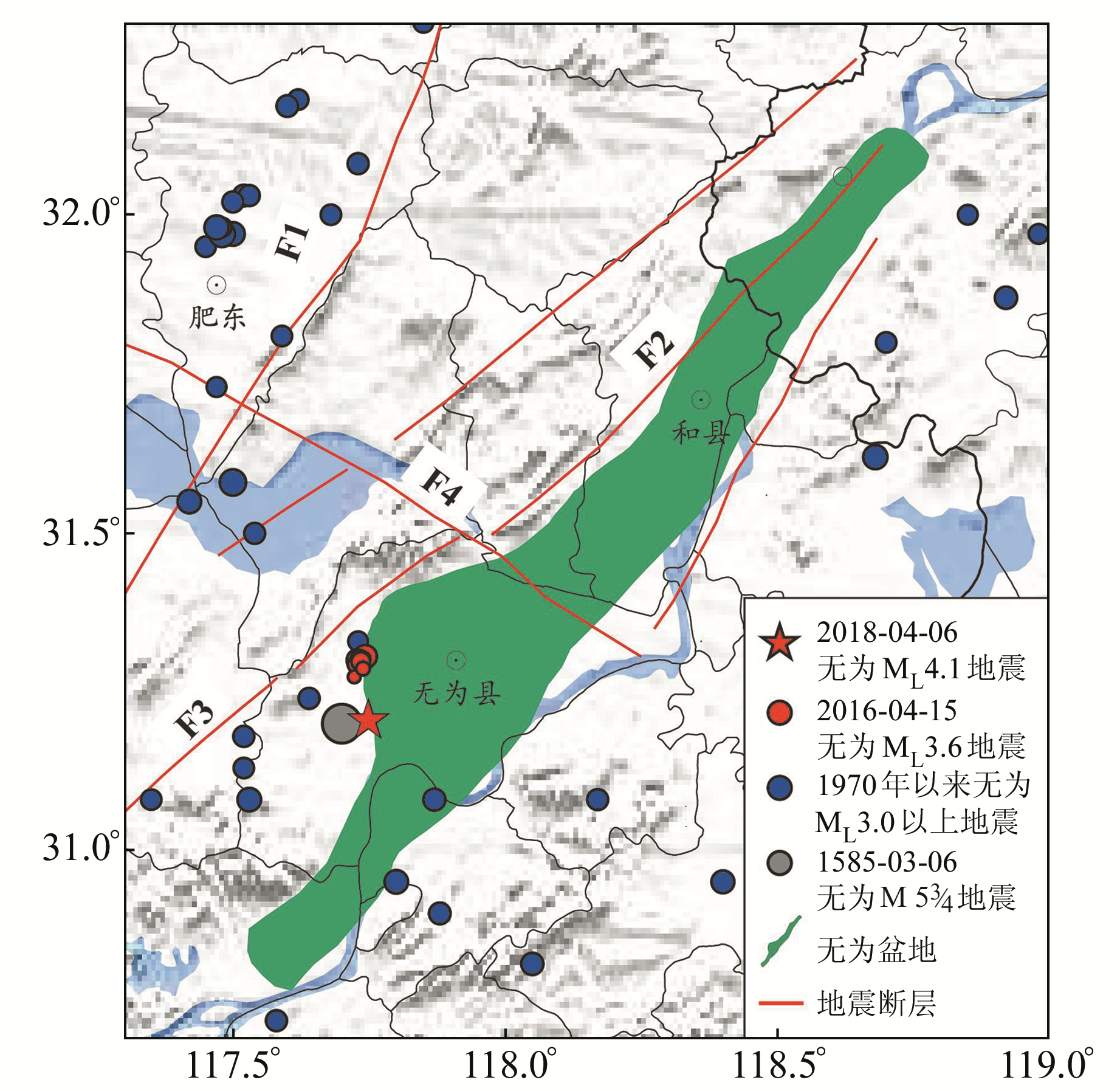
2018-04-06安徽无为发生的ML4.1地震位于无为盆地西南边界(图 1),盆地内部及其边界断裂以NE、NW向为主[1-2]。2016年盆地西南侧有震群活动,倪红玉等[3]认为其可能是由严家桥-枫沙湖断裂活动引起。无为ML4.1地震位于严家桥-枫沙湖断裂东侧,距离2016年无为ML3.6震群约9 km,判断此次地震的发生是否与严家桥-枫沙湖断裂活动有关,在区域地震形势判定中尤为重要。

|
F1:郯庐断裂;F2:江浦-六合断裂;F3:严家桥-枫沙湖断裂;F4:桥头集-东关断裂;图中阴影部分为无为盆地[2] 图 1 研究区域内地质构造分布及1970年以来的地震分布(ML≥3.0) Fig. 1 Tectonic setting and the distribution of earthquakes(ML≥3.0) from 1970 in the study area |
本文采用CAP方法[4]对无为ML4.1地震的震源机制解和震源深度进行反演,采用双差定位方法[5]对2016年以来无为地区发生的地震进行重新定位,并结合区域地质构造信息,综合分析无为ML4.1地震的发震构造。
1 震源深度和震源机制解CAP方法将地震记录分为体波和面波2个部分,并允许震相到时在给定的时间窗内滑动,较好地改善了波形拟合中因速度模型差异引起的到时误差[4]。
1.1 数据根据地震波形信噪比高、P波初动明显、台站对地震事件包围相对完整的原则,挑选震中距在74~266 km之间的台站数据。对选取的数据去除仪器响应,坐标转换至大圆路径,并采用4阶Butterworth带通滤波器对波形进行滤波,体波部分带宽0.15~0.2 Hz,面波部分带宽0.05~0.1 Hz。将滤波后的波形与理论波形进行拟合,在合成理论地震图时,采用频率-波数方法[6],参考无为地震震中附近的CRUST2.0速度模型,分别对频率和波数进行积分,利用传播矩阵方法计算各种频率下的全部波形。
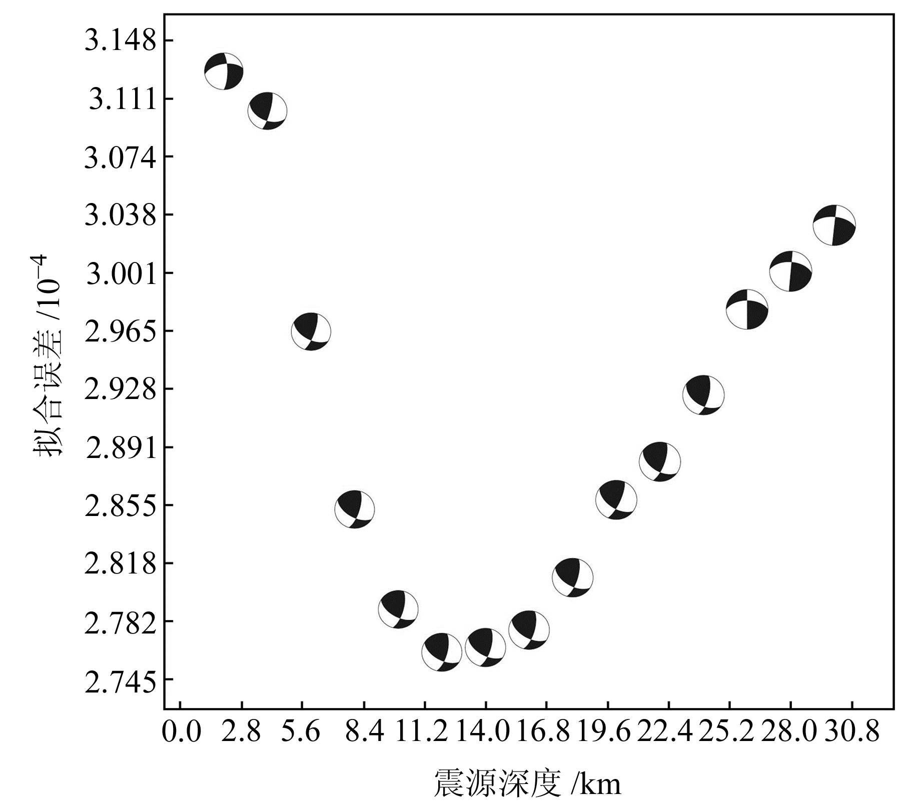
1.2 震源深度和震源机制反演地震观测波形与理论波形拟合误差随深度的分布如图 2所示,在深度12 km左右拟合误差函数值为极小值(2.762×10⁻⁴),该深度对应的震源机制解即为此次无为地震的最优震源机制解。如表 1所示,无为ML4.1地震震源机制解为:节面Ⅰ,走向120°,倾角57°,倾向SW,滑动角27°,运动方式为左旋走滑,有一定的逆断分量;节面Ⅱ,走向15°,倾角68°,倾向SE,滑动角144°,运动方式为右旋走滑,有一定的逆断分量。P轴方位角为NE向,倾角近水平,T轴方位角为NW向,倾角为41°。

|
图 2 无为ML4.1地震震源机制反演中波形拟合误差随深度的变化 Fig. 2 Misfit variation with focal depth of the Wuwei ML4.1 earthquake |
|
|
表 1 无为ML4.1震源机制参数 Tab. 1 Focal mechanisms of the Wuwei ML4.1 earthquake |
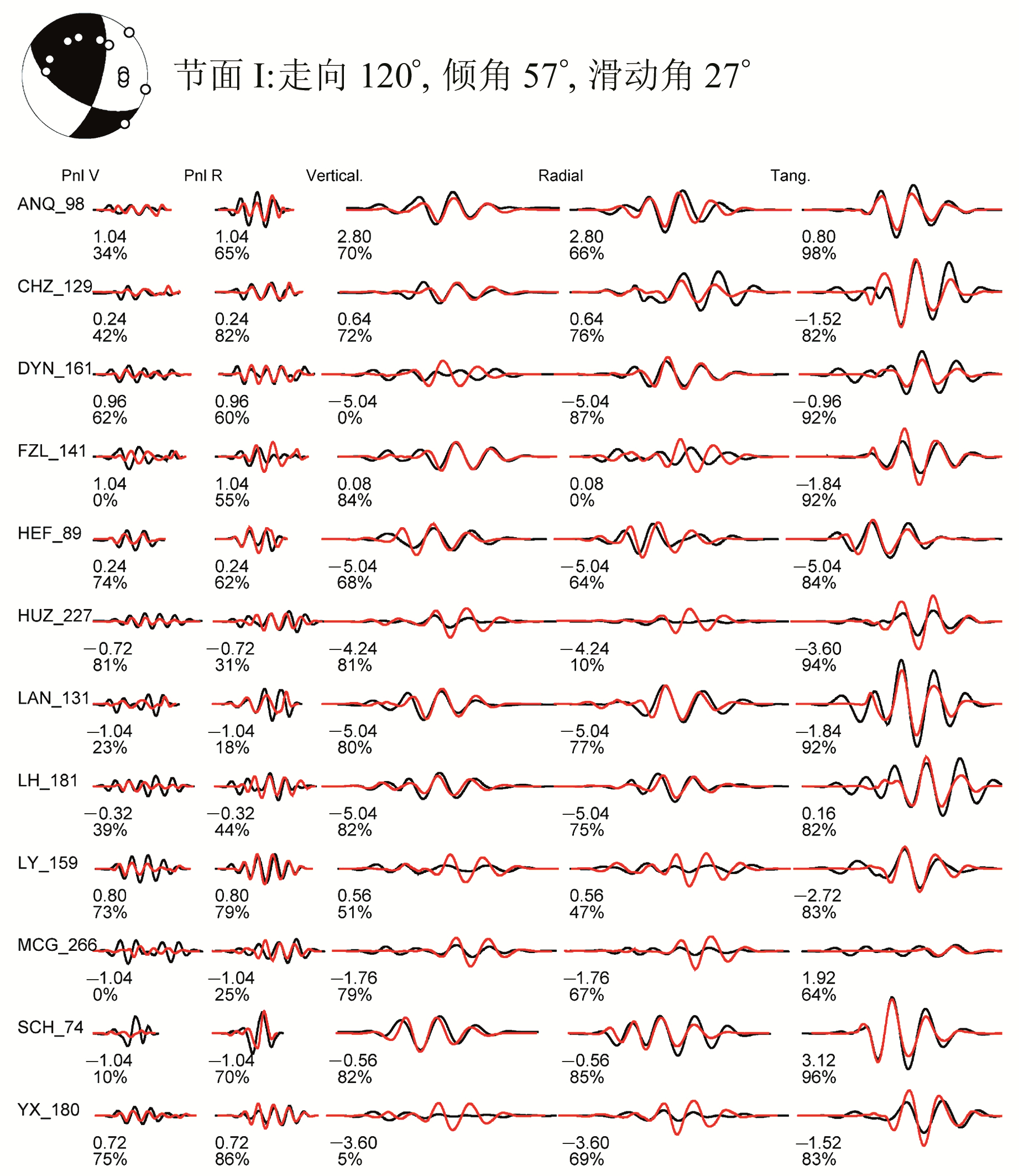
如图 3所示,在参与波形拟合的60个震相中,拟合相关系数大于60%的占70%,反演结果相对可靠。

|
波形左侧为地震观测台站和震中距(单位km),波形下面依次为计算波形和观测波形的到时差(单位s)及计算波形和观测波形的相关系数 图 3 无为ML4.1地震计算的地震波形(红色)与实际观测波形(黑色)的对比图 Fig. 3 Comparision between calculated seismograms (red) and observed ones (black) of the Wuwei ML4.1 earthquake |
刘建达等[7]认为,定位精度较高的地震空间分布与区域构造的几何特征有密切的关系,可以较好地确定地震的发震构造。双差定位[5]通过反演得到丛集地震中每个地震事件的相对位置,减小了地壳速度结构差异对定位精度的影响,在地震定位研究中应用广泛[8-10]。
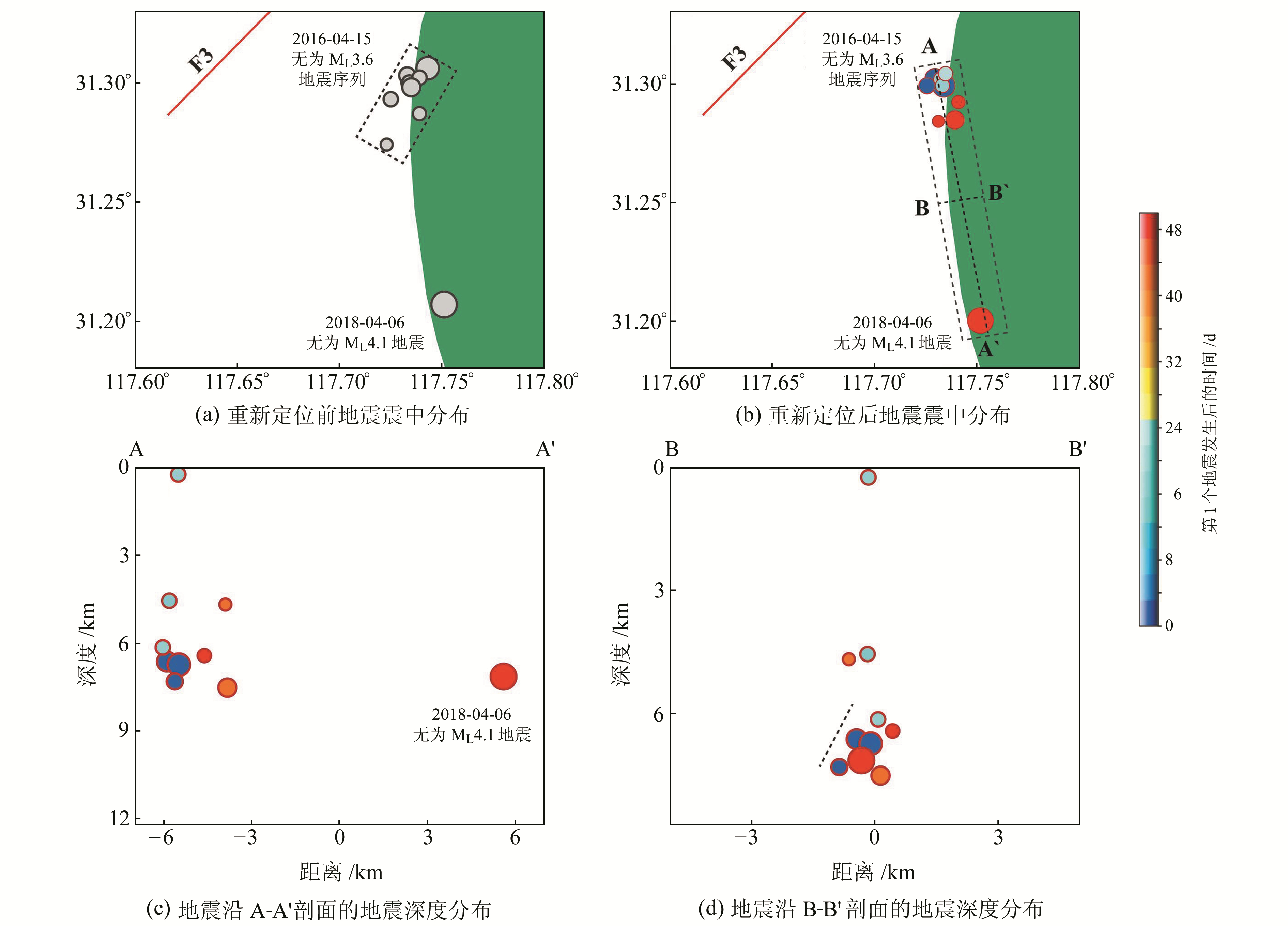
为进一步确定无为地震的发震构造,对2016年无为震群和无为ML4.1地震进行重新定位。在定位过程中,最小连接数和最小观测数设置为8,震源间距小于10 km,地震到台站的距离小于200 km,P波到时的权重为1.0,S波到时的权重为0.7。双差定位后的地震水平空间分布如图 4所示,可以看出,重定位后地震位于无为盆地西南边界,呈NW向分布,与无为盆地西南边界的走向一致。相对于重定位前(图 4(a)),重定位后无为ML3.6震群的相对位置变化较为显著,重定位前震群分布的优势方向为30°NE,重定位后的优势方向为30°NW,震中分布更为集中。由图 4(b)还可以看出,2016年无为震群存在有序破裂的现象,震中由NW向SE迁移。无为ML4.1地震位于震群的东南,距离2016年无为ML3.6震群的中心约9 km。

|
阴影部分为无为盆地[2] 图 4 2010年以来无为地区地震重新定位前、后震中分布图 Fig. 4 Distributions of earthquake epicenters before and after precise relocation |
由震源深度剖面(图 4(c))可以看出,沿震中分布的优势长轴走向(A-A′)地震序列的深度主要集中在3~8 km。垂直于震中优势长轴走向的剖面(B-B′)(图 4(d))反映了沿地震破裂方向震源分布的几何特征,在0~6 km的深度,地震分布近乎直立;在6~8 km的深度,地震优势分布的倾向为SW,倾角较陡,与反演得到的无为ML4.1地震震源机制解节面Ⅰ的倾向和倾角一致性较好。
本文反演得到的无为ML4.1地震的应力轴参数与该地区构造应力场相关的研究结果一致[11],说明该地震是在区域应力场作用下发生的构造性地震事件。双差定位结果显示, 2016年无为震群和2018-04-06无为ML4.1地震沿无为盆地的西南边界随时间由NW向SE迁移。地震水平空间分布的优势方向为NW向,与盆地边界的走向和反演得到的地震震源机制解节面Ⅰ的走向较为一致,推测此次地震的断层面为震源机制解的节面Ⅰ,破裂方向为SE向。
3 结语严家桥-枫沙湖断裂的走向为NE向[12],与本文反演的无为ML4.1地震震源机制解节面的走向和重新定位后无为地区地震水平空间分布的优势方向并不一致,无法确定无为ML4.1地震的发生是否与该断裂活动有关。反演得到地震的震源深度为12 km,为早三叠世以前的地层[1-2],层内发育由NW向SE滑移的台阶状逆冲断层。无为ML4.1地震震源机制解节面Ⅰ的运动方式以走滑为主,有一定的逆冲分量,与该深度内断层的运动类型符合较好。综上所述,认为2018-04-06无为ML4.1地震是在区域构造应力场作用下,由无为盆地西南边界底部的NW向断裂运动引起的地震事件。
| [1] |
徐曦, 高顺莉. 下扬子区新生代断陷盆地的构造与形成[J]. 地学前缘, 2015, 22(6): 148-166 (Xu Xi, Gao Shunli. The Structure and Formation of the Genozoic Fault Basin in the Lower Yangze Region[J]. Earth Science Frontiers, 2015, 22(6): 148-166)
(  0) 0) |
| [2] |
徐曦, 朱晓颖, 单希鹏, 等. 下扬子区中生代沿江盆地群的盆地结构与沉积特征[J]. 石油实验地质, 2018, 40(3): 303-314 (Xu Xi, Zhu Xiaoying, Shan Xipeng, et al. Structure and Sedimentary Characteristics of the Meso-Cenozoic Basin Group along the Yangtze River in the Lower Yangtze Region[J]. Petroleum Geology and Experiment, 2018, 40(3): 303-314)
(  0) 0) |
| [3] |
倪红玉, 刘泽民, 洪德全, 等. 2016年安徽无为MS3.0震群序列发震构造与震后趋势研究[J]. 中国地震, 2017, 33(3): 365-373 (Ni Hongyu, Liu Zemin, Hong Dequan, et al. Research on Seismogenic Structure and Aftershock Tendency of the Wuwei MS3.0 Earthquake Swarm Sequence, Anhui in 2016[J]. Earthquake Research in China, 2017, 33(3): 365-373 DOI:10.3969/j.issn.1001-4683.2017.03.002)
(  0) 0) |
| [4] |
Zhao L S, Helmberger D V. Source Estimation from Broadband Regional Seismograms[J]. Bulletin of the Seismological Society of America, 1994, 84(1): 91-104
(  0) 0) |
| [5] |
Waldhauser F, Ellsworth W L. A Double-Difference Earthquake Location Algorithm: Method and Application to the Northern Hayward Fault, California[J]. Bulletin of the Seismological Society of America, 2000, 90(6): 1 353-1 368 DOI:10.1785/0120000006
(  0) 0) |
| [6] |
Zhu L P, Helmberger D V. Advancement in Source Estimation Techniques Using Broadband Regional Seismograms[J]. Bulletin of the Seismological Society of America, 1996, 86(5): 1 634-1 641
(  0) 0) |
| [7] |
刘建达, 李清河, 张元生, 等. 江苏中、南部及邻区地震重新定位及在断层研究中的应用[J]. 地球物理学进展, 2009, 24(1): 58-66 (Liu Jianda, Li Qinghe, Zhang Yuansheng, et al. Hypocenter Relocation in Central and Southern Jiangsu Province and Adjacent Areas, China and Its Application to Fault Research[J]. Progress in Geophysics, 2009, 24(1): 58-66)
(  0) 0) |
| [8] |
房立华, 吴建平, 王未来, 等. 四川芦山MS7.0级地震及其余震序列重定位[J]. 科学通报, 2013, 58(20): 3 451-3 459 (Fang Lihua, Wu Jianping, Wang Weilai, et al. Relocation of Mainshock and Aftershock Sequences of MS7.0 Sichuan Lushan Earthquake[J]. Chinese Science Bulletin, 2013, 58(20): 3 451-3 459)
(  0) 0) |
| [9] |
王未来, 吴建平, 房立华, 等. 2014年云南鲁甸MS6.5地震序列的双差定位[J]. 地球物理学报, 2014, 57(9): 3 042-3 051 (Wang Weilai, Wu Jianping, Fang Lihua, et al. Double Difference Location of the Ludian MS6.5 Earthquake Sequences in Yunnan Province in 2014[J]. Chinese Journal of Geophysics, 2014, 57(9): 3 042-3 051)
(  0) 0) |
| [10] |
王亮, 黄金水, 焦明若, 等. 盖州震群的重新定位[J]. 中国地震, 2015, 31(2): 439-446 (Wang Liang, Huang Jinshui, Jiao Mingruo, et al. Accurate Relocation of Earthquake Swarm in Gaizhou, Liaoning, China[J]. Earthquake Research in China, 2015, 31(2): 439-446 DOI:10.3969/j.issn.1001-4683.2015.02.030)
(  0) 0) |
| [11] |
汪素云, 许忠淮. 中国东部大陆的地震构造应力场[J]. 地震学报, 1985, 7(1): 17-32 (Wang Suyun, Xu Zhonghuai. Seismo-Tectonic Stress Field in East China[J]. Acta Seismologica Sinica, 1985, 7(1): 17-32)
(  0) 0) |
| [12] |
翟洪涛, 邓志辉, 周本刚, 等. 1585年安徽巢县南地震核查与发震构造探讨[J]. 地震地质, 2009, 31(2): 295-304 (Zhai Hongtao, Deng Zhihui, Zhou Bengang, et al. Research on the Historical Data of the 1985 AD Chaoxian Earthquake and Its Seismogenic Structure[J]. Seismology and Geology, 2009, 31(2): 295-304 DOI:10.3969/j.issn.0253-4967.2009.02.010)
(  0) 0) |
2. Fujian Earthquake Agency, 7 Huahong Road, Fuzhou 350003, China
 2019, Vol. 39


