 2017, Vol. 37


Sentinel-1(S-1)是欧空局(ESA)合成孔径雷达(SAR)数据服务专用星座,用于中等分辨率大面积重复轨道干涉测量,重访周期6 d,其中宽幅模式(IW)和超宽幅模式(EW)可进行干涉测量。S-1采用TOPS成像技术,其优点是影像一致性好、噪声小,但在方位向存在多普勒频率变化,使得干涉数据处理特别是配准要求更高。
TOPS成像最早在TerraSAR-X上[1-3]测试,在Radarsat-2上进行成像实验[4-5]。基于这两个平台获取的TOPS SAR数据,Zan等[6-8]对TOPS成像模式及干涉条件进行分析,研究TOPS影像burst的配准、拼接。Holzner等[9]阐述了burst的干涉处理方法。Prats-Iraola等[10-11]证明了TOPS SAR用于重轨干涉的可行性,并对谱分解法(SD)和增强谱分解法(ESD)的配准精度进行评估。Prats-Iraola等[12]对卫星轨道及其对干涉的影响进行分析,指出顺轨向轨道误差能导致burst同步误差,必须予以校正。Yague-Martinez等[13]分析IW模式TOPS SAR影像方位向多普勒频移差异,获取玻利维亚Salar de Uyuni地区干涉图。González等[14]通过burst干涉处理,最早将S-l TOPS影像用于Fogo火山监测。Crosetto等[15]通过2014-10~2015-01的S-1影像进行PS法时间序列分析,获取Mexico DF主城区变形时间序列及变形累积图,指出配准误差会在方位向引起线性干涉条纹,并就burst级别干涉处理、PS选点以及相位解缠等进行讨论。Wen等[16]利用GAMMA软件处理升降轨S-1A TOPS数据,获取2015年中国Pishan地震同震形变场,展示了其地震变形探测和断层识别的能力。本文将S-1 SAR影像干涉处理应用于门源地震同震变形监测。
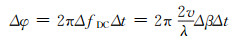
1 S-1A影像干涉处理 1.1 影像配准S-1A TOPS SAR干涉处理过程与其他SAR系统相同,但TOPS成像造成雷达波束存在视角差异,SAR影像多普勒频移差异较大,配准误差会导致线性相位梯度,这种线性相位在方位向尤为明显。设在方位向主从burst影像的配准误差为Δt,则burst方位向相位差异为:
|
(1) |
式中,ΔfDC为burst方位向多普勒中心频率变化值,Δβ为对应的方位向视角变化值。对S-1A,ΔfDC最大为5.2 kHz,Δβ为±0.6°,为使得相位坡度小于1/100(3.6°),方位向的配准精度需优于0.000 9像元,约合1.9 μs或1.3 cm。
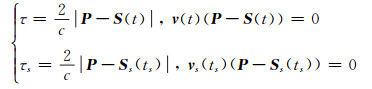
针对上述要求,本文采用基于SRTM DEM和S-1A精密轨道的成像几何配准法[17],如图 1所示。在地心直角坐标系下,主从影像的卫星位置向量为S (t)和S s(ts),速度向量为


|
图 1 S-1A成像几何图 Fig. 1 Geometric of S-1A imaging |
|
(2) |
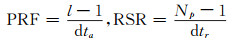
式(2)构建了地面像元与其成像时间的相互关系。像元位置与脉冲重复频率PRF及距离向采样率RSR的关系可表示为:
|
(3) |
式中,l为方位向总行数,dta为总成像时间,Np为距离向像元数,dtr为往返零多普勒时间。
1.2 bursts拼接为获取整景S-1A影像的干涉图,需克服burst拼接时因配准误差导致的干涉相位差。目前有两种方法:一种是先进行burst级别的干涉处理,然后计算burst重叠区域的干涉图之差,并将差分相位分配到burst上,消除相位跳变,完成有效行/列的拼接;另一种方法是将重叠区域的差分相位转化成配准偏移量,实现整景影像的配准和拼接,最后获取影像级别的干涉图。如图 2所示,图中用不同框线表示对重叠区域干涉图之差的两种不同处理方法。

|
图 2 S-1A TOPS SAR干涉处理流程 Fig. 2 Flow chart of S-1A TOPS SAR interferometry |
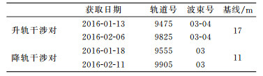
2016-01-21青海门源发生6.4级地震,震源深度10 km,地震中心(37.68°N,101.62°E)位于平均海拔4 000 m以上的祁连山。S-1A获取了地震前后的4幅TOPS影像,组成升降轨干涉对(表 1),降轨的第3个burst完全覆盖地震变形区域,而升轨则需要第3、4个burst拼接,如图 3所示。在读取主从影像后,利用SRTM DEM(90 m分辨率)根据主影像参数模拟SAR影像,并利用移动窗口技术获取其与从影像的粗略偏差,然后利用成像几何法进行精密配准。为减小计算量,在方位向每10个像元、距离向每100个像元选取1个控制点,计算主从影像控制点偏差,剔除粗差[18]并利用最小二乘法计算方位向和距离向整体偏差,见表 2。
|
|
表 1 S-1A干涉对影像参数 Tab. 1 Parameters of S-1A interferometric pairs |

|
图 3 门源地震升降轨干涉对及覆盖区域 Fig. 3 Coverage of descending and ascending interferometric pairs at Menyuan earthquake |
|
|
表 2 门源地震TOPS影像配准 Tab. 2 Coregistration of TOPS images covering Menyuan earthquake |
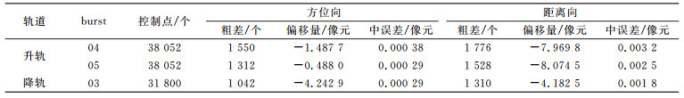
图 4展示了升降轨道获取的地震区干涉图(多视数1×5,像元大小约20 m×20 m),其中图 4(a)由升轨burst04和burst05拼接而成,拼接时并未作滤波或羽化处理。可以看出:1)虽然变形区域位于冰雪覆盖、高差变化大的山区,但由于干涉基线短,干涉条纹清晰;2)干涉图在方位向没有出现明显的线性条纹,达到了TOPS影像对配准精度要求;3)升轨burst04和burst05拼接处无明显相位跳跃,拼接效果良好;4)升降轨获取的同震干涉条纹数相同。图 5为经过相位解缠后的变形图和地震中心距离向和方位向剖面图,负值表示沿雷达视线向的抬升量(1 rad=4.4 mm)。可以看出,地震变形区域为椭圆形,方位向(近南北向)约22 km,距离向约20 km(近东西向),雷达视线向最大抬升约70 mm。值得一提的是,干涉条纹图中出现了多处因冰川滑动和山体滑坡引起的干涉条纹,图 6展示了红色矩形区域Google Earth影像及差分干涉图叠加到DEM上的效果。

|
图 4 门源地震TOPS干涉图 Fig. 4 Interferograms of TOPS images at Menyuan earthquake area |

|
图 5 门源地震相位解缠图与剖面图(多视数1×5) Fig. 5 Unwrapped phase and deformation profile of the Menyuan earthquake |

|
图 6 地震引起的冰川移动 Fig. 6 Glaciers movement caused by the earthquake |
论文研究了TOPS影像的特点及干涉处理方法,获取了门源地震变形图。
1) TOPS成像方式造成影像方位向较大的多普勒频率差异,为使得干涉图方位向线性相位小于3.6°,方位向配准精度要控制在0.000 9像元内;
2) 基于DEM和卫星精密轨道的配准方法不会因影像失相干而无法确定控制点,且配准精度高,满足TOPS影像的配准要求;
3) 实现了谱分解法(ESD)TOPS影像burst之间的拼接,干涉相位无明显相位跳跃,拼接效果良好;
4) 利用升降轨数据获取青海门源地震一致的同震变形场,雷达视线向最大抬升约70 mm。
S-1A开放、免费、连续固定的数据服务政策,可为地震过程、火山活动、滑坡和地表沉降监测提供连续的SAR数据源。下一步将重点研究利用TOPS影像进行时序干涉变形监测。
致谢: S-1A TOPS影像数据由欧空局提供,感谢CTTC遥感部Monserrat等对数据处理方法的讨论与支持,感谢武汉大学李陶对论文写作的建议。
| [1] |
Meta A, Mittermayer J, Prats P, et al. TOPS Imaging with TerraSAR-X:Mode Design and Performance Analysis[J]. IEEE Transactions on Geoscience & Remote Sensing, 2010, 48(2): 759-769
(  0) 0) |
| [2] |
Scheiber R, Wollstadt S, Sauer S, et al.Sentinel-1 Imaging Performance Verification with TerraSAR-X[C].8th European Conference on Synthetic Aperture Radar (EUSAR), VDE, 2010
( 0) |
| [3] |
Mittermayer J, Prats P, Aria D, et al.TOPS Sentinel-1 and TerraSAR-X Processor Comparison Based on Simulated Data[C].8th European Conference on Synthetic Aperture Radar (EUSAR), VDE, 2010
( 0) |
| [4] |
Davidson G, Mantle V, Bernhard R, et al.Implementation of TOPS Mode on Radarsat-2 in Support of the Sentinel-1 Mission[C].Living Planet Symp, Edinburgh, 2013
( 0) |
| [5] |
Davidson G, Mantle V, Bernhard R, et al.Implementation of TOPS Mode on Radarsat-2 in Support of the Sentinel-1 Mission: Radarsat-2 TOPS SAR Interferometry (InSAR) Scene Pair Data Acquisitions[C].European Space Agency, Paris, 2014
( 0) |
| [6] |
Zan F D, Guarnieri A M M. TOPSAR:Terrain Observation by Progressive Scans[J]. IEEE Transactions on Geoscience & Remote Sensing, 2006, 44(9): 2352-2360
( 0) |
| [7] |
Zan F D, Guarnieri A M, Rocca F, et al.Sentinel-1 Radar Interferometry Applications[C].7th European Conference on Synthetic Aperture Radar (EUSAR), VDE, 2008
( 0) |
| [8] |
Zan F D, Prats-Iraola P, Scheiber R, et al.Interferometry with TOPS: Coregistration and Azimuth Shifts[C].10th European Conference on Synthetic Aperture Radar (EUSAR), VDE, 2014
( 0) |
| [9] |
Holzner J, Bamler R. Burst-Mode and ScanSAR Interferometry[J]. IEEE Transactions on Geoscience & Remote Sensing, 2002, 40(9): 1917-1934
( 0) |
| [10] |
Prats-Iraola P, Scheiber R, Marotti L, et al. TOPS Interferometry with TerraSAR-X[J]. IEEE Transactions on Geoscience & Remote Sensing, 2012, 50(8): 3179-3188
( 0) |
| [11] |
Scheiber R, Jäger M, Prats-Iraola P, et al. Speckle Tracking and Interferometric Processing of TerraSAR-X TOPS Data for Mapping Nonstationary Scenarios[J]. IEEE Journal of Selected Topics in Applied Earth Observations and Remote Sensing, 2015, 8(4): 1709-1720 DOI:10.1109/JSTARS.2014.2360237
( 0) |
| [12] |
Prats-Iraola P, Rodriguez-Cassola M, Zan F D, et al. Role of the Orbital Tube in Interferometric Spaceborne SAR Missions[J]. IEEE Geoscience & Remote Sensing Letters, 2015, 12(7): 1486-1490
( 0) |
| [13] |
Yagüe-Martínez N, Prats-Iraola P, González F R, et al. Interferometric Processing of Sentinel-1 TOPS Data[J]. IEEE Transactions on Geoscience & Remote Sensing, 2016, 54(4): 2220-2234
( 0) |
| [14] |
González P J, Bagnardi M, Hooper A J, et al. The 2014-2015 Eruption of Fogo Volcano:Geodetic Modeling of Sentinel-1 TOPS Interferometry[J]. Geophysical Research Letters, 2015, 42(21): 9239-9246 DOI:10.1002/2015GL066003
( 0) |
| [15] |
Crosetto M, Devanthéry N, Cuevasgonzález M, et al.Exploitation of the Full Potential of PSI Data for Subsidence Monitoring[C].The International Association of Hydrological Sciences, 2015
( 0) |
| [16] |
Wen Y M, Xu C J, Liu Y, et al. Deformation and Source Parameters of the 2015 MW6.5 Earthquake in Pishan, Western China, from Sentinel-1A and ALOS-2 Data[J]. Remote Sensing, 2016, 8(2): 134 DOI:10.3390/rs8020134
( 0) |
| [17] |
Sansosti E, Berardino P, Manunta M, et al. Geometrical SAR Image Registration[J]. IEEE Transactions on Geoscience & Remote Sensing, 2006, 44(10): 2861-2870
( 0) |
| [18] |
黄其欢, 何秀凤. SAR影像配准中控制点粗差剔除方法研究[J]. 遥感技术与应用, 2007, 22(1): 75-78 (Huang Qi-huan, He Xiufeng. The Gross Error Removing Methods for Control-Point Selection in SAR Registration[J]. Remote Sensing Technology and Application, 2007, 22(1): 75-78 DOI:10.3969/j.issn.1004-0323.2007.01.015)
( 0) |
| [19] |
吴文豪, 李陶, 陈志国, 等. Sentinel-1A卫星TOPS模式数据干涉处理[J]. 测绘通报, 2016(2): 42-45 (Wu Wenhao, Li Tao, Chen Zhiguo, et al. Interferometric Processing of TOPS Mode for Sentinel-1A[J]. Bulletin of Surveying and Mapping, 2016(2): 42-45)
( 0) |