2. 中国地震局地球物理研究所,北京市民族大学南路5号,100081
2015-04-25尼泊尔首都加德满都西北约80 km处发生MW7.8地震,05-12在主震东南方向发生MW7.3强余震。MW7.8地震发生在印度板块与欧亚板块交界的喜马拉雅碰撞造山带中段[1]。由陆态网络基准站和尼泊尔境内GPS观测资料解算获得的静态同震形变场表明,尼泊尔MW7.8地震在近场产生显著的地表同震位移[2]。然而这主要给出地震造成的静态同震变形,无法反映震时地表动态变形过程。随着GPS接收机技术和存储能力不断提高,GPS的观测精度和对形变谱的敏感性逐渐朝着测量地壳动态瞬时变化的方向发展[3]。目前,高频(1 Hz)GPS被广泛应用于大地震震时地表动态位移观测[4-6]和震源破裂过程反演[7],为地震学研究提供了一条新的途径。本文利用陆态网络和尼泊尔境内高频(1 Hz)GPS观测数据,研究2015年尼泊尔MW7.8和MW7.3地震震时近场地表动态变形过程,并与邻近强震仪观测资料进行对比,为研究地震动态破裂过程提供基础资料。
1 1 Hz GPS数据与处理方法数据来源于陆态网络和尼泊尔境内GPS基准站(图 1)。数据处理采用GAMIT/GLOBK[8]的TRACK运动学分析模块(1.29版本)。采用IGS精密星历,以L1和L2的线性组合LC为观测量消除电离层一阶项的折射影响,对流层天顶延迟改正采用GPT模型[9],映射函数采用GMF模型[10],模糊度解算采用MW-WL组合模型[11-12]。分析各GPS站的稳定性后,选取陆态网络基准站西藏班戈(XZBG)作为参考站进行长距离动态GPS数据处理,其中参考站与各流动站的基线长度约为290~940 km,计算得到尼泊尔MW7.8和MW7.3地震期间各1 Hz GPS站的动态位移时间序列。为削弱多路径误差影响,采用改进的恒星日滤波法[13]对该时序进行滤波处理。

|
图 1 尼泊尔地震构造背景及1 Hz GPS点位分布 Fig. 1 Tectonic setting of the Nepal earthquake and location of 1 Hz GPS stations |
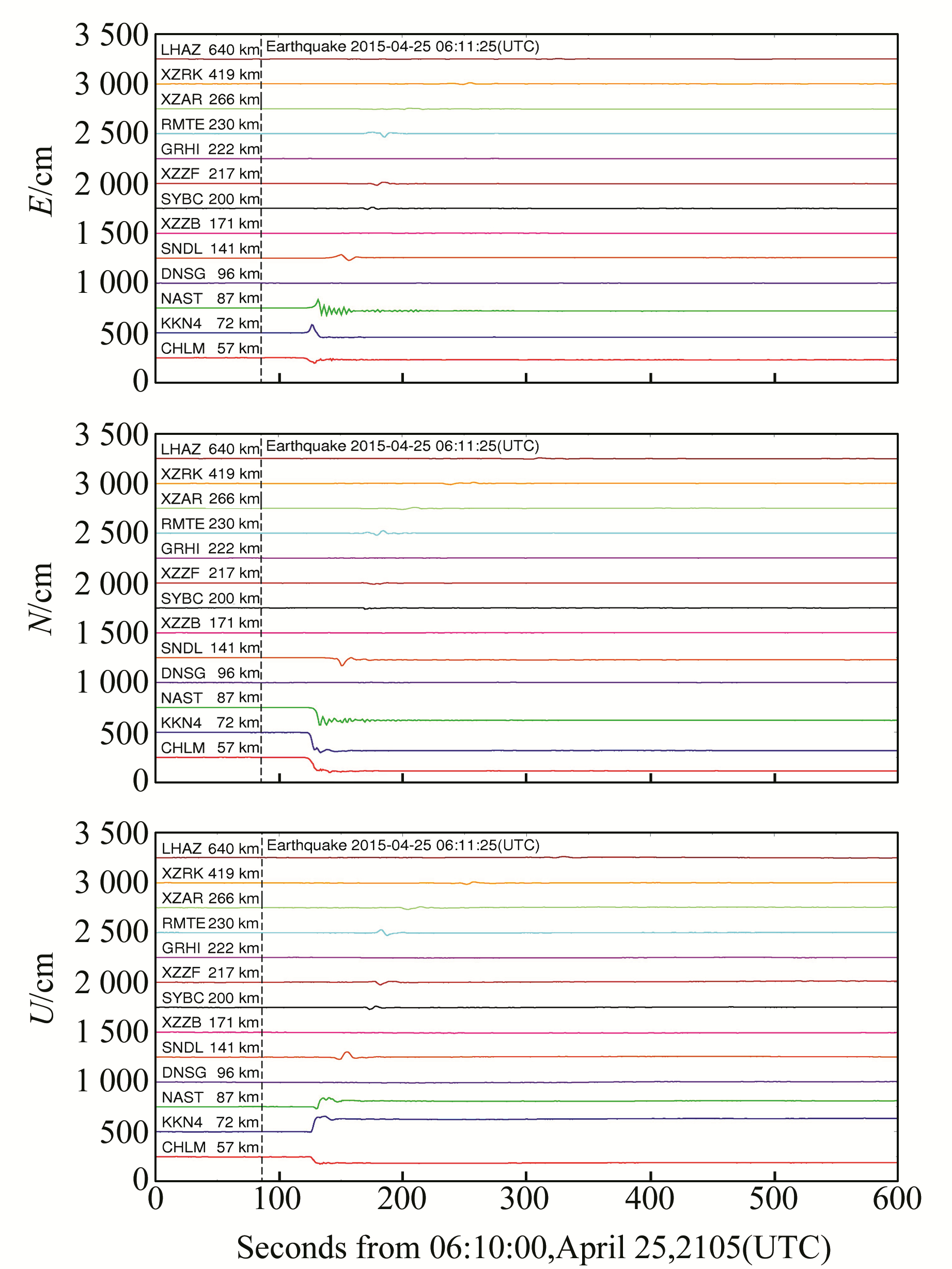
图 2为尼泊尔MW7.8地震期间各1 Hz GPS站东西向、南北向和垂直向动态位移时间序列。可以看出,震中东侧的CHLM、KKN4、NAST站动态位移最为显著,其中CHLM站向西最大位移为55.55 cm,向南最大位移为153.58 cm,向下最大位移为75.76 cm。KKN4站向东最大位移为80.93 cm,向南最大位移为203.70 cm,向上最大位移为154.69 cm。NAST站向东最大位移为83.51 cm,向南最大位移为174.96 cm,向上最大位移为90.42 cm。上述测站位移幅度远大于GPS动态形变中误差1.5 cm,说明计算结果可靠。震中西侧的DNSG站向东最大位移为0.98 cm,向南最大位移为2.05 cm,向上最大位移为4.39 cm,远小于震中东侧与之基本对称的NAST站。地震引起的地表变形主要发生在震中东侧,而地震破裂传播的方向性可能是震中东西两侧高频GPS站动态位移差异的主要原因。

|
图 2 尼泊尔MW7.8地震期间各1 Hz GPS站东西向、南北向和垂直向动态位移时序 Fig. 2 Time series of site displacements in east-west, north-south and up-down components detected from 1 Hz GPS stations during the Nepal MW7.8 earthquake |
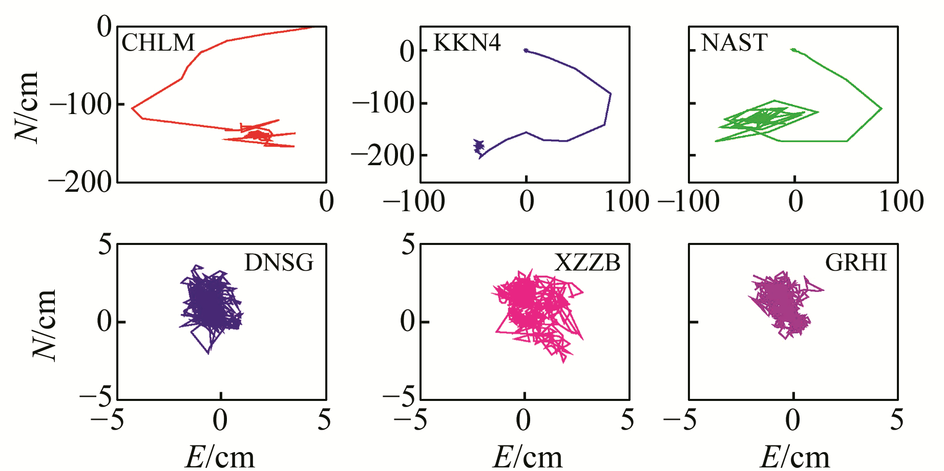
图 3为震中附近1 Hz GPS站水平运动轨迹,其中坐标原点(0,0)为各测站震前初始位置。可以看出,处于震中东侧的CHLM、KKN4、NAST站均向西南方向运动,但运动方式有所差异:CHLM先朝西南,然后再转折向东南运动;KKN4和NAST先朝东南,然后再转折向西运动。处于震中西侧的DNSG、XZZB、GRHI围绕原点作随机运动,其运动幅度与误差相当,表明各测站在尼泊尔MW7.8地震期间未发生明显位移。

|
图 3 尼泊尔MW7.8地震期间震中附近1 Hz GPS站点的水平运动轨迹 Fig. 3 Horizontal trajectory of near-field 1 Hz GPS stations during the Nepal MW7.8 earthquake |
图 4为尼泊尔MW7.3地震期间各1 Hz GPS站东西向、南北向动态位移时间序列。可以看出,地震发生前各1 Hz GPS站未发生明显的异常变形,地震发生后,各GPS站均记录到不同幅度的地表运动,地表运动幅度随震中距增加而衰减。距震中最近的SYBC站最先感知地震波,地震期间SYBC站向西最大位移为4.55 cm,向南最大位移为13.15 cm。值得注意的是,位于加德满都附近的NAST站和KKN4站虽然震中距基本相同,但震时动态位移幅度差异显著,主要原因可能是NAST站位于加德满都沉积盆地,该测站震时动态位移由于盆地效应被放大,而KKN4站位于基岩上[14]。

|
图 4 尼泊尔MW7.3地震期间各1 Hz GPS站东西向、南北向的动态位移时序 Fig. 4 Time series of site displacements in east-west, north-south components detected from 1 Hz GPS measurements during the Nepal MW7.3 earthquake |
尼泊尔MW7.8地震发生后,距震中约640 km的高频GPS站LHAZ记录到此次地震引起的动态地表变形过程。LHAZ站与邻近强震仪LSA相距约6 km,强震仪数据处理采用零线校正方法[15],将LSA记录的加速度波形进行二次积分获得地表动态位移,LHAZ站与LSA站观测到的震时地表动态位移如图 5所示。可以看出,在地震波到达后,LHAZ站与LSA站震时动态位移在振幅和相位上具有很好的一致性,虽然高频GPS噪声水平高于强震仪,但是高频GPS可以完整捕获地震期间地表动态变形过程。因此,在特大地震发生且地震仪限幅的情况下,高频GPS可以为地震仪提供重要补充。

|
图 5 高频GPS(LHAZ)与强震仪(LSA)观测到的地表位移对比 Fig. 5 Comparison of the displacements from strong motion seismograph and 1 Hz GPS measurements during the Nepal MW7.8 earthquake |
通过对陆态网络和尼泊尔境内高频GPS观测数据进行处理分析,获得尼泊尔MW7.8和MW7.3地震震时近场地表动态变形过程。结果表明,MW7.8地震震中东侧高频GPS站地表动态位移显著,西侧动态位移幅度较小,地震破裂传播的方向性可能是震中东西两侧高频GPS站动态位移差异的主要原因。MW7.3地震在震中周围产生一定程度的地表运动,但幅度较小。将高频GPS(LHAZ站)与邻近强震仪(LSA站)震时动态位移时序进行对比发现,二者具有较好的一致性。虽然高频GPS噪声水平高于强震仪,但是高频GPS可以完整捕获地震期间地表动态变形过程,可为尼泊尔MW7.8和MW7.3地震动态破裂过程研究提供基础资料。
致谢: “中国大陆构造环境监测网络”提供GPS观测数据,UNAVCO提供尼泊尔境内GPS观测数据,武汉大学GNSS中心耿江辉教授提供强震仪数据,特此感谢。
| [1] |
Avouac J P, Meng L, Wei S, et al. Lower Edge of Locked Main Himalayan Thrust Unzipped by the 2015 Gorkha Earthquake[J]. Nature Geoscience, 2015, 8(9): 708-711 DOI:10.1038/ngeo2518
(  0) 0) |
| [2] |
苏小宁, 王振, 孟国杰, 等. GPS观测的2015年尼泊尔MS 8.1地震震前应变积累及同震变形特征[J]. 科学通报, 2015(22): 2115-2123 (Su Xiaoning, Wang Zhen, Meng Guojie, et al. Pre-Seismic Strain Accumulation and Co-Seismic Deformation of the 2005 Nepal MS8.1 Earthquake Observed by GPS[J]. Chin Sci Bull, 2015(22): 2115-2123)
(  0) 0) |
| [3] |
Bock Y, Prawirodirdjo L. Detection of Arbitrarily Large Dynamic Ground Motions with a Dense High-Rate GPS Network[J]. Geophys Res Lett, 2004, 31: 1-4
(  0) 0) |
| [4] |
Larson K M, Bodin P, Gomberg J. Using 1 Hz GPS Data to Measure Deformations Caused by the Denali Fault Earthquake[J]. Science, 2003, 300: 1421-1424 DOI:10.1126/science.1084531
(  0) 0) |
| [5] |
Gang L, Bin Z, Rui Z, et al. Near-Field Surface Deformation During the April 20, 2013, Ms7.0 Lushan Earthquake Measured by 1-Hz GNSS[J]. Geodesy and Geodynamics, 2013, 4(2): 1-5
(  0) 0) |
| [6] |
Grapenthin R, Freymueller J T. The Dynamics of a Seismic Wave Field:Animation and Analysis of Kinematic GPS Data Recorded During the 2011 Tohoku-Oki Earthquake, Japan[J]. Geophysical Research Letters, 2011, 38(18): 113-120
(  0) 0) |
| [7] |
Miyazaki S, Larson K M, Choi K, et al. Modeling the Rupture Process of the 2003 September 25 Tokachi-Oki (Hokkaido) Earthquake using 1 Hz GPS Data[J]. Geophysical Research Letters, 2004, 31(21): 177-178
(  0) 0) |
| [8] |
Herring T A, King R W, McClusky S C.Introduction to GAMIT/GLOBK[R].Mass Inst of Technol, 2010
(  0) 0) |
| [9] |
Boehm J, Heinkelmann R, Schuh H. A Global Model of Pressure and Temperature for Geodetic Applications[J]. J Geodesy, 2007, 81(10): 679-683 DOI:10.1007/s00190-007-0135-3
(  0) 0) |
| [10] |
Boehm J, Niell A, Tregoning P, et al. Global Mapping Function (GMF):A New Empirical Mapping Function Based on Numerical Weather Model Data[J]. Geophys Res Lett, 2006, 33: 1-4
(  0) 0) |
| [11] |
Melbourne W G.The Case for Ranging in GPS-Based Geodetic Systems[C].First International Symposium on Precise Positioning with the Global Positioning System, 1985
(  0) 0) |
| [12] |
Wübbena G.Software Developments for Geodetic Positioning with GPS Using TI-4100 Code and Carrier Measurements[C].First International Symposium on Precise Positioning with the Global Positioning System, 1985
(  0) 0) |
| [13] |
Choi K, Bilich A, Larson K M, et al. Modified Sidereal Filtering:Implications for High-Rate GPS Positioning[J]. Geophysical Research Letters, 2004, 31(22): 178-198
(  0) 0) |
| [14] |
Galetzka J, Melgar D, Genrich J F, et al. Slip Pulse and Resonance of the Kathmandu Basin during the 2015 Gorkha Earthquake, Nepal[J]. Science, 2015, 349(6252): 1091-1095 DOI:10.1126/science.aac6383
(  0) 0) |
| [15] |
Iwan W D, Moser M A, Peng C Y. Some Observations on Strong-Motion Earthquake Measurement Using a Digital Accelerograph[J]. Bulletin of the Seismological Society of America, 1985, 75(5): 1225-1246
(  0) 0) |
2. Institute of Geophysics, CEA, 5 South-Minzudaxue Road, Beijing 100081, China
 2017, Vol. 37


